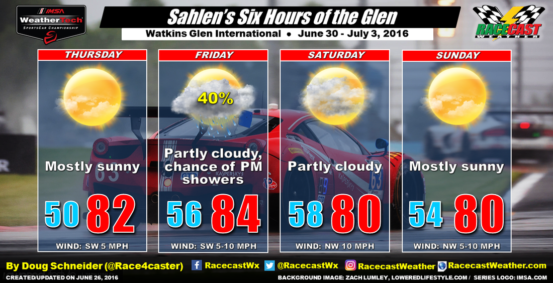
By Doug Schneider The weather continues to look terrific this weekend at Watkins Glen. The latest data continues to point toward a chance of showers and thunderstorms on Friday when a cold front an upper level trough will move across the region, but you couldn't ask for better weather on Saturday and Sunday, with plenty of sunshine and pleasant temperatures.
By Doug Schneider I'm happy to report that the weather for this year's Six Hours of the Glen looks much better than last year. The conditions last year were really difficult for teams to deal with, as there were on and off showers through most of the race. While there is a chance of rain that may affect some of the support races on Friday afternoon, I'm confident that the Six Hours on Sunday will be held in dry conditions.
By Scott Martin. Saturday is going to be a great day weather-wise out at Road America. Skies will be mostly sunny throughout the daytime hours, with a few clouds moving in during the late afternoon and early evening hours. Afternoon highs will be in the mid 80s. Winds will be out of the south at 10-15 MPH. Chance of rain during the day time hours is 0%.
By Scott Martin. Forecast has changed ever so slightly for the overnight hours on Saturday and into the day on Sunday. Looks like the main timeframe for showers and storms to be in the Road America area will be from 3AM - 11AM Sunday morning. With an approaching cold front and instability already in place, the SPC had defined the Elkhart Lake and Plymouth areas under a Marginal Risk for severe storms until 7AM Sunday morning. The progs on this system is not really all that impressive for severe storms in this part of the state, but the 0-6km bulk shear will increase to 25 to 35 knots, and CAPE values will be in the 1,000 to 2,000 j/kg range, so an isolated severe storm could be possible. Main threat will be from dangerous cloud-to-ground lightning, damaging winds, and some hail.
By Scott Martin. Drier air will work into the area for Friday, as a high pressure area will move in during the overnight hours tonight and into the early morning hours on Friday. Some fog may form during the early morning hours, but otherwise skies will be sunny and temperatures will be warm. Afternoon highs will top out in the upper 70s. Winds will start off out of the northeast at 5-10 MPH during the morning, but will shift out of the southeast at 5-10 MPH during the afternoon. Chance of rain is 0%.
By Scott Martin. Good morning. Let's start off with the potential for severe weather today at Road America, since teams and officials are arriving and paddock setup begins. The Storm Prediction Center has defined the southern half of Wisconsin under a risk for severe storms during the day today. The Elkhart Lake and Plymouth areas have been placed under a "Slight Risk" throughout the day today. A surface low will move across or just south of the area during the afternoon and evening hours. Latest models have the low south of the state, and that will keep most of the more unstable air south of the area. Where that surface low moves this afternoon will determine where the best chance for severe weather to form today. Looking at the latest run of the HRRR Simulated Radar, showers and thunderstorms will start to move through the area. These will be below severe limits. With this model run, a derecho forms around the 5PM hour across southern Wisconsin and moves quickly off to the southeast. Good news with this run is that the strongest part of the storm will be south of the track. Instability values will be well below numbers to support severe storm formation, and Significant Tornado Parameters will be at 0. It looks like Road America will be dodging a bullet for today, but there could be a "fly in the ointment." If the low is 25 to 50 miles more northward when it moves across this afternoon, the severe threat will be greatly increased as the more unstable air would be in the area. I'll have radar up and running today so you can keep up to date with approaching storms and warnings. Main threat today will be damaging winds, large hail, and a few tornadoes. Please stay weather aware as this could be a serious situation if it moves north of the forecast. Now for the event forecast. Thursday will start off cloudy with a slight chance of showers and storms lingering from today's action. Otherwise, with a high starting to build in the southern part of the state and with winds out of the northeast, this will dry out the airmass and conditions will improve during the day. Afternoon highs will only be in the mid 70s.
On Friday, mid-level ridging will be in control of the weather, and great weather will be expected. Sunny skies and warm, with daytime highs near 80. Winds will shift during the morning starting off out of the west then out of the south before noon. On Saturday, the ridging starts to shift to the east and moisture levels will start to rise. This will be an increase in instability to the area during the peak of daytime heating, and there is a slight chance for an afternoon or evening isolated shower or storm to develop. Otherwise, mostly sunny skies and warm, with afternoon highs in the low to mid 80s. A surface low will drag a prefontal trough across the area for Sunday, and this will bring in a decent chance for showers and storms. There is some agreement in the models that has the precipitation diminishing during the afternoon hours. Otherwise, skies will me mostly sunny and afternoon highs will be in the mid 80s. By Scott Martin. As you can see by the image above, over half of the state has been placed in some risk for severe storms for Wednesday. Road America, along with Plymouth and Elkhart Lake has been placed under a "slight risk" for severe weather throughout the day.
There may be a few storms that will move through the area during the morning hours, and these have the possibility to be severe, with large hail being the main threat. The main risk for severe weather will come later in the day during the late afternoon and evening hours. With a surface low and warm front being close by, developing storms should quickly become severe. All modes of severe weather will be possible: tornadoes, large hail, damaging winds and heavy rainfall. There is still some uncertainty on the placement of these storms tomorrow evening. If there is a 25 mile jog to the north with these storms, the severe threat could increase. If they are 25 miles farther to the south, the severe threat will be less. I'll have an update later tonight on the conditions expected tomorrow. I'll have radar on the site running that will have lightning data and storm warnings active. Have your source of weather information handy, as tomorrow will be a busy day in Wisconsin. By Scott Martin. Well I am back from my long break from posting forecasts on the blog, and what a way to come back with the awesome weekend of racing at Road America! Warm temperatures ahead during the daytime activities, and you will definitely need the hats, shades, and the sunscreen.
Just a heads up for the track crew, race teams and series officials, Wednesday looks like there may be a chance of strong to severe weather that could move over the track. A surface low will be setting up over or just to the south of the Wisconsin/Illinois border, and this will bring in plenty of instability. According to where the exact placement happens, strong to severe storms could happen over the area, or most of the energy will stay to the south and just have a chance for storms below severe limits. Will update on this situation tomorrow. As far as the rest of the event, there may be a few showers or storms left over early on Thursday, but the day looks mainly dry. Temperatures will start to warm up for the weekend, under mostly sunny skies for Friday through Sunday. An impulse could move across the area on Saturday bringing a chance of showers and storms, but models are not in agreement with placement or amounts of rain at this moment. Rain chances for Saturday and Sunday may be tweaked as we get closer to those days. Highs will be in the low to mid 80s for Friday through Sunday. |
Social Feeds
Authors
Doug Schneider Categories
All
Archives
January 2025
|