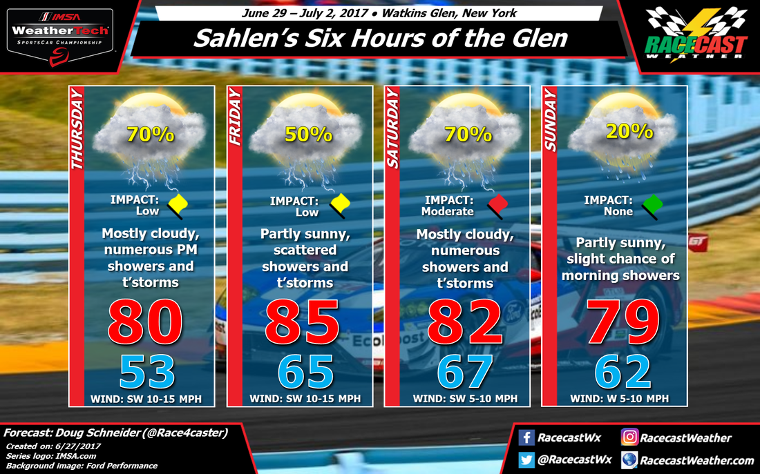
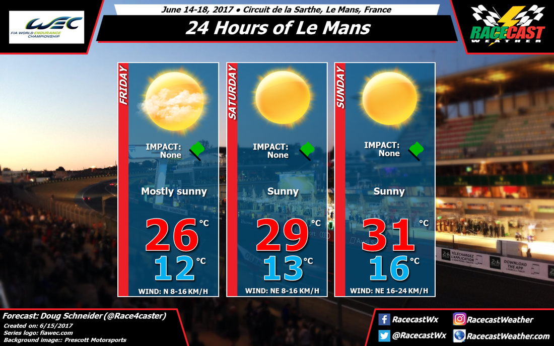
By Doug Schneider - @Race4caster
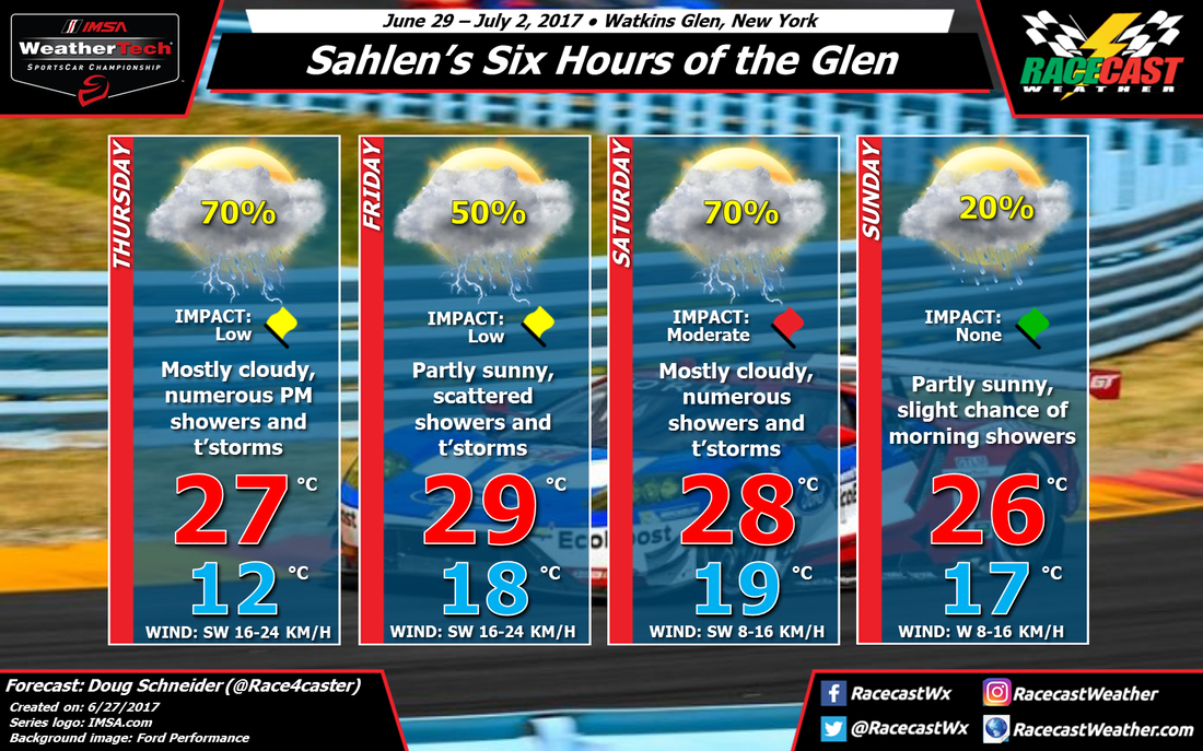
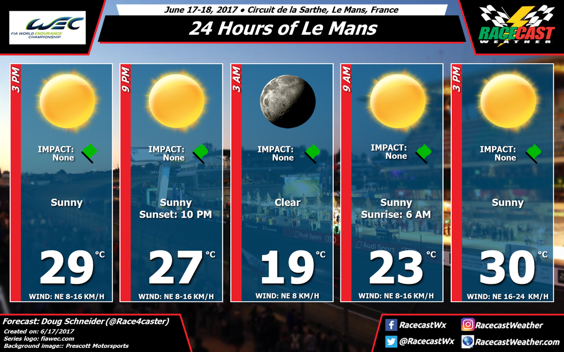
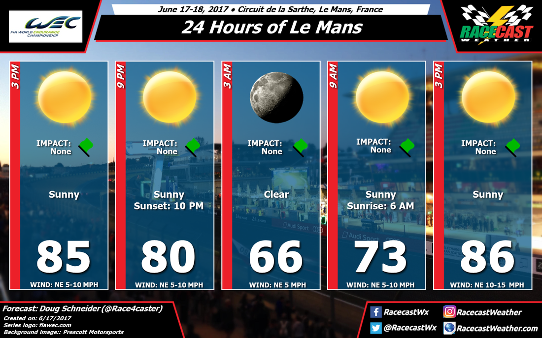
 |  Forecast in Celsius and km/h. Click to enlarge |
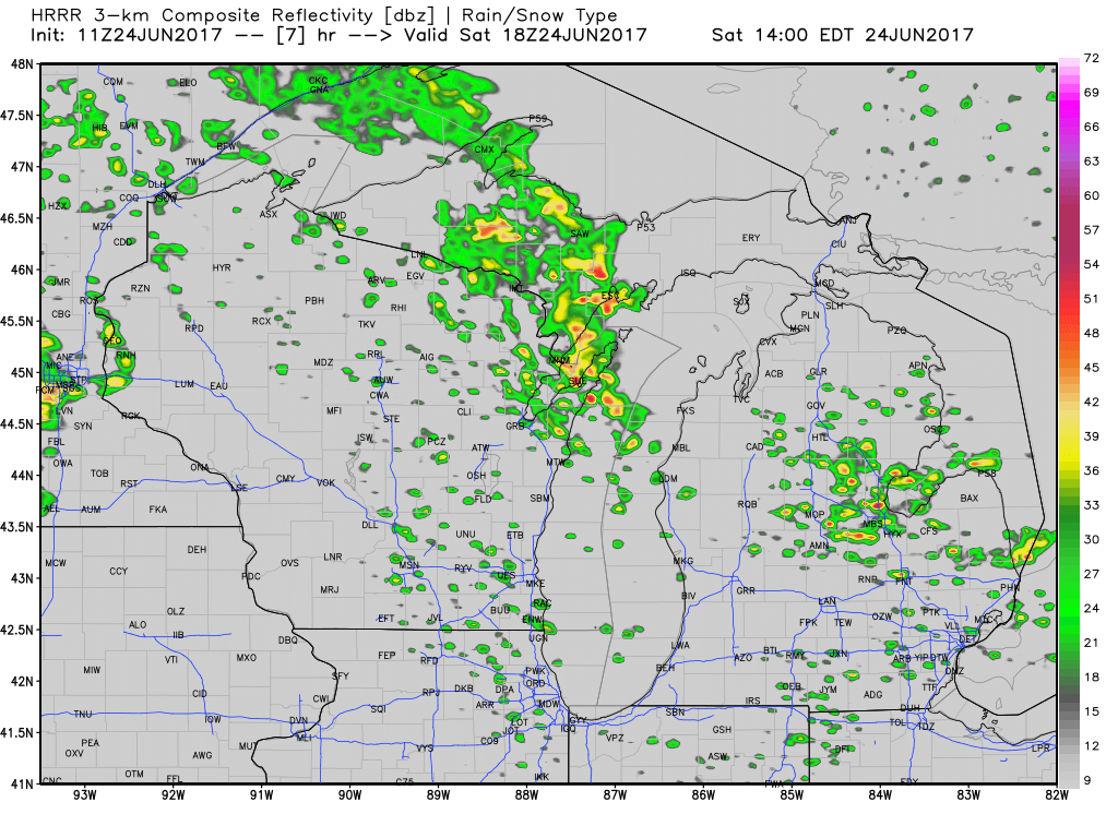
The rain managed to avoid Watkins Glen yesterday, passing to the north and to the south. That won't repeat today. Here's a look at the big picture radar this morning:
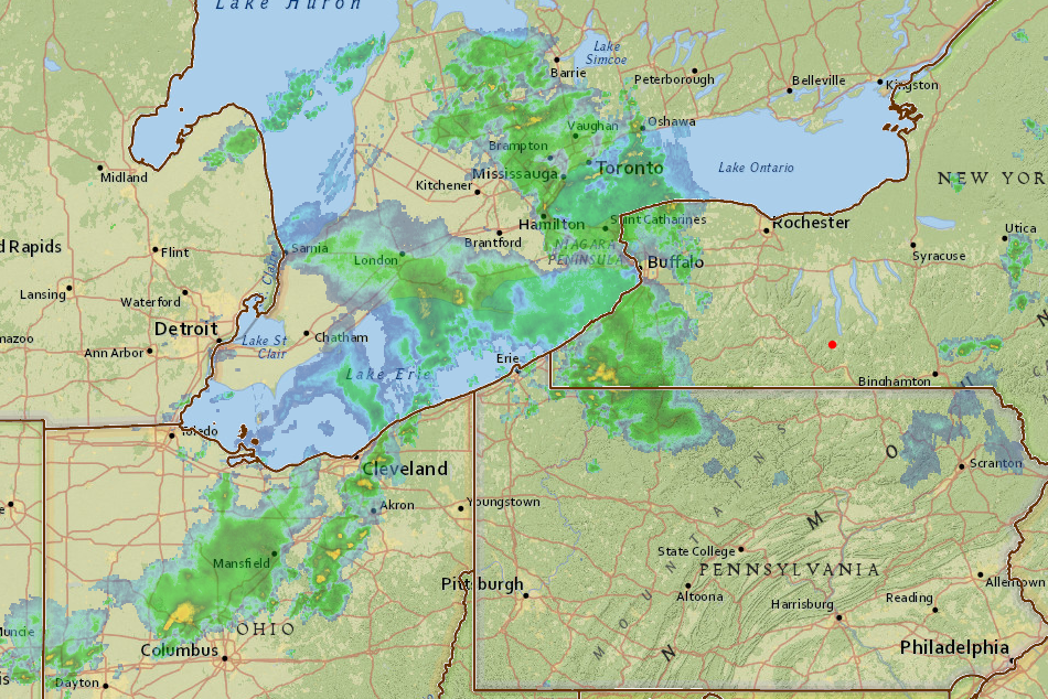
Movement of the rain in the image is toward the northeast (Watkins Glen is at the red dot). The first area of rain that is over western New York and northern Pennsylvania will produce some light rain at the track this morning, mainly between 8 and 10 am. Only a few hundredths of an inch can be expected from this initial round, and a period of dry conditions and partial sunshine can be expected behind it late in the morning and early in the afternoon.
A second area of rain is located over Ohio, associated with a disturbance in the mid and upper levels of the atmosphere. It is this disturbance that will bring numerous showers and storms to the track this afternoon, and it will be aided by increasing instability as temperatures warm up. The most likely time period for storms will be between noon and 5 pm, so the Prototype Challenge and Lamborghini Super Trofeo races may be impacted, with wet conditions or possibly delays. There is a slight risk of severe storms, capable of producing damaging winds and hail. While the chance of a severe storm is low, lightning and heavy rain will be the greater risks at the track today, and fans at the track need to stay aware of the weather and be prepared to seek shelter once thunder is heard. If you can hear thunder, you are close enough to be struck by lightning.
Storms this afternoon will move east by sunset, and the overnight hours should mostly be dry. But the chance of rain will increase again on Saturday. I expect that there will be a greater impact on the racing, due to a better chance of heavier rain and strong or severe storms than today. A cold front will move across the area, and storms ahead of it are expected from the late morning into the early afternoon. Gusty winds, heavy rain, and lightning can be expected. Again, there is a slight risk that storms in the area will be severe, capable of producing damaging winds and large hail. All storms will produce lightning and heavy rainfall. If a storm passes directly over the track, a quick half inch of rain may fall.
It's a little hard to be specific on timing, but right now I think the window for the best chance of rain Saturday will be between 10 am and 4 pm. I would not be surprised if IMSA WeatherTech qualifying was cancelled. The start of the CTSC race will likely be impacted by wet conditions, or possibly delayed.
The timing of this system is looking a little faster than before, and I'm confident that the front will be through the area Saturday evening. The storms associated with the front will be long gone by Sunday morning, however there will still be an upper level trough over the area, so I can't completely rule out the chance of an isolated shower on Sunday. It is most likely that the entire 6-hour race will stay dry. If there are showers in the area, they are most likely to occur in the mid to late afternoon when a little instability can develop, near the end or after the end of the race.
Our radar link at the top of the page is up and running for Watkins Glen to help you stay aware of approaching storms.
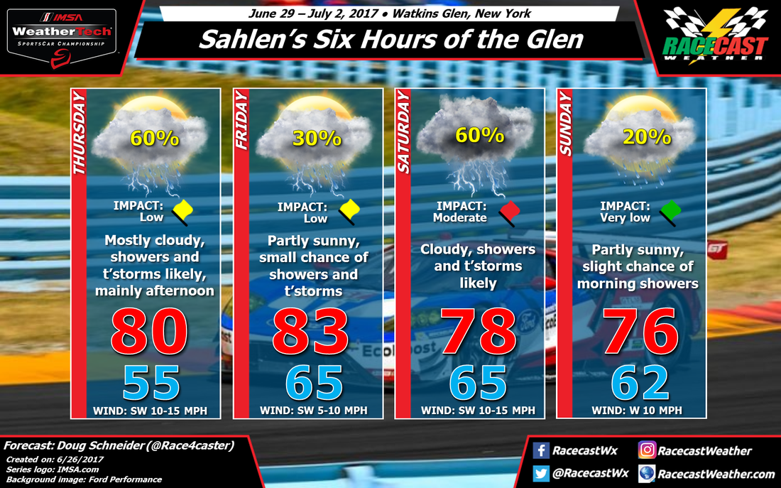