On Thursday, a front will be pushing southward across Oklahoma and northern Texas. This will bring a good chance of showers and thunderstorms at the track as teams load in and start to practice. Storms will be possible at any time of the day, but it looks like the afternoon will have the best chances. Indications are that this front will push through on Thursday night, and high pressure will build in behind it. A northeasterly flow of dry air around the high should provide dry and mostly sunny conditions on Friday and Saturday, with comfortable temperatures and humidity levels both days.
|
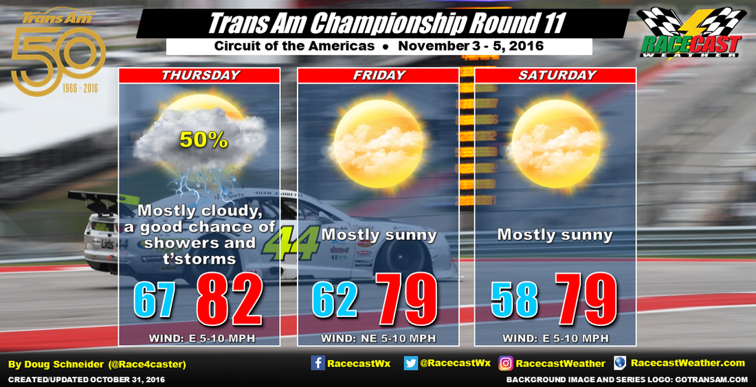
By Doug Schneider The penultimate round of the Trans Am Series will be at COTA this weekend, and after a front moves through on Thursday, the weather looks like it will be nice in time for race day.
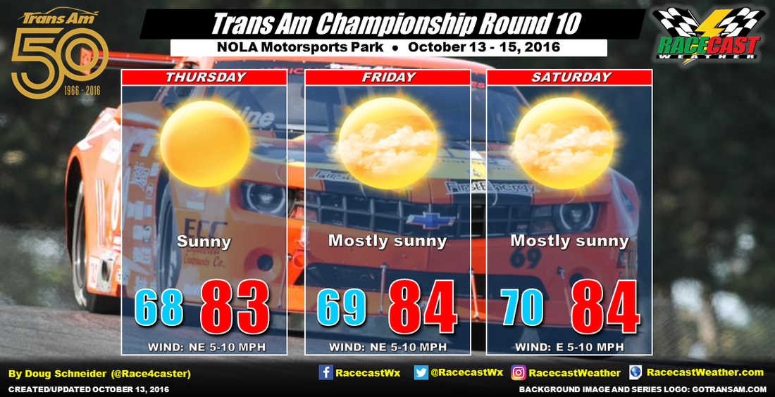
On Thursday, a front will be pushing southward across Oklahoma and northern Texas. This will bring a good chance of showers and thunderstorms at the track as teams load in and start to practice. Storms will be possible at any time of the day, but it looks like the afternoon will have the best chances. Indications are that this front will push through on Thursday night, and high pressure will build in behind it. A northeasterly flow of dry air around the high should provide dry and mostly sunny conditions on Friday and Saturday, with comfortable temperatures and humidity levels both days. By Doug Schneider Not much change to the forecast for Trans Am's weekend at NOLA Motorsports Park. High pressure will be firmly in control through Saturday. The chance of any rain on Saturday has dropped to virtually zero, and plenty of sunshine is expected through the whole event. Temperatures should be pretty comfortable too, reaching to the mid 80s.
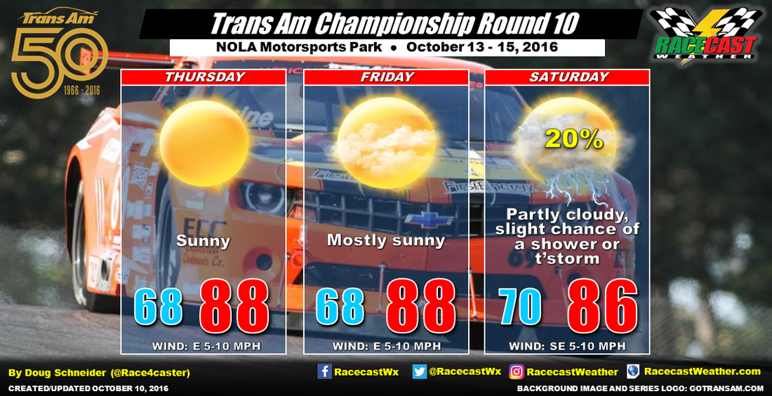
By Doug Schneider Trans Am has a quick turn around, going from Homestead to NOLA in back-to-back weekends. The good weather that the series enjoyed in Homestead will likely continue in NOLA this weekend.
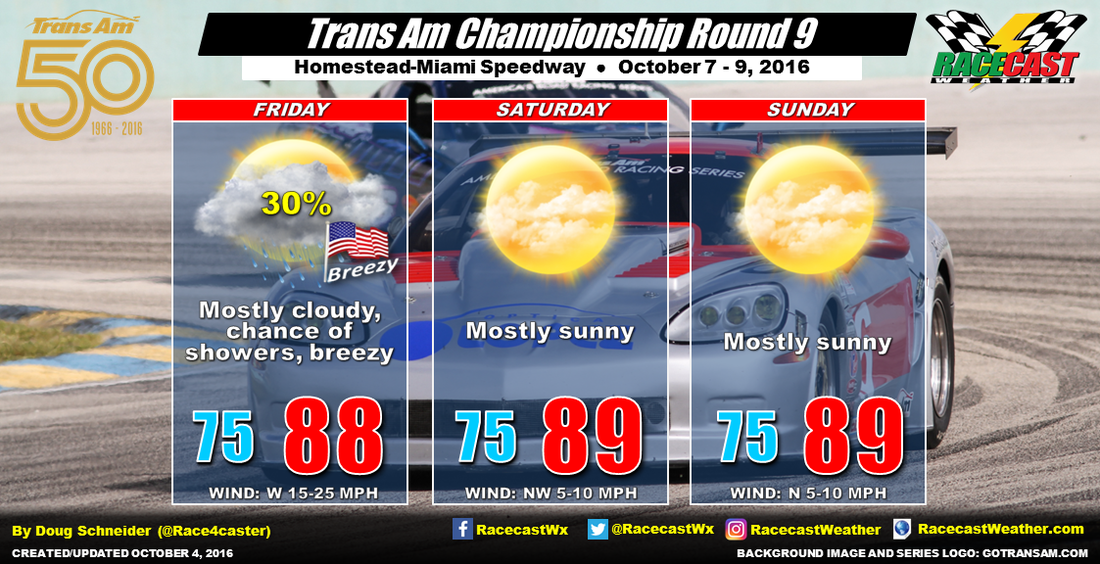
The weather pattern through mid-week will feature a large high pressure ridge over the Mississippi and Tennessee Valley region, which will supply dry and stable air from the north into Louisiana. This will provide sunny to mostly sunny skies at the track on Thursday and Friday, and the humidity levels will be relatively comfortable for New Orleans. The high pressure area will be shifting east, becoming positioned near the Atlantic coast. This will result in a more southeasterly flow off the Gulf of Mexico into Louisiana, and higher humidity levels. The added moisture will bring more clouds, and possibly an isolated shower or thunderstorm on Saturday. At this point, it doesn't look like a big deal, and I only have the chance of rain at 20%. Most likely, the race will be run in dry conditions. By Doug Schneider Homestead-Miami Speedway was spared the brunt of Hurricane Matthew on Thursday. The maximum wind speed recorded at the airport, which is very close to the speedway, was a gust of 38 mph. The total rainfall from Matthew was 0.95 inches.
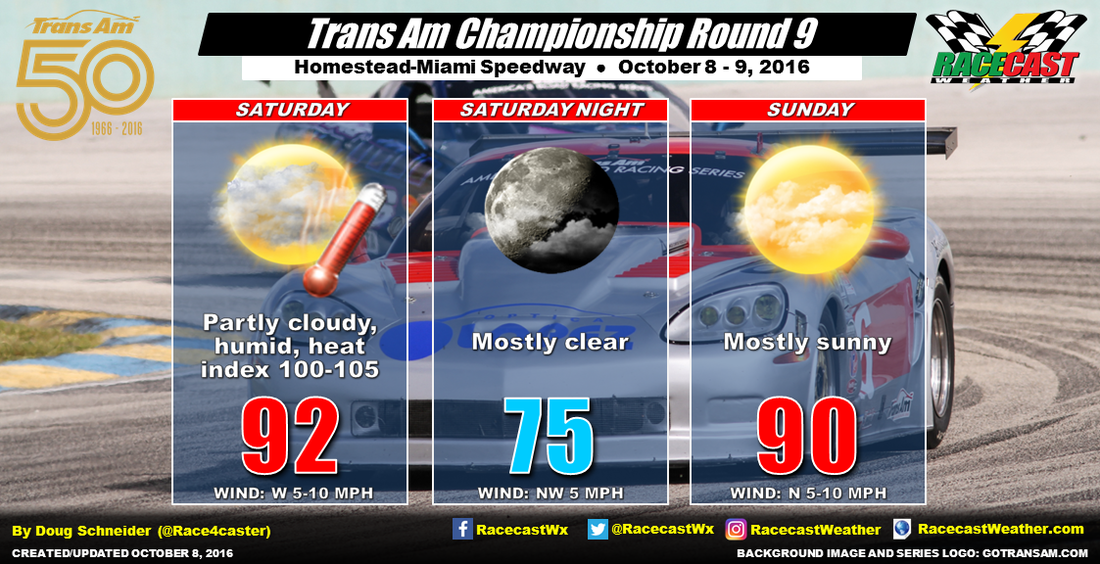
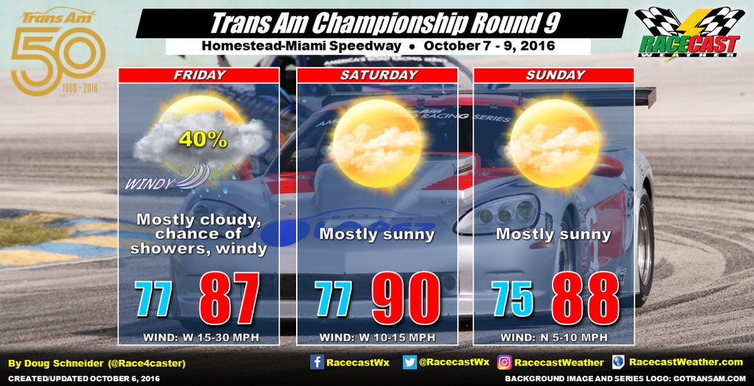
Today will be hot and humid, as highs will be in the lower 90s, and dewpoint temperatures will be in the mid to upper 70s. The humidity will make it feel like it is over 100 degrees. If you're at the speedway, stay hydrated and take frequent breaks in a shaded area. Tomorrow should have slightly lower dewpoints, in the lower 70s, so it won't feel quite as muggy as today. Highs will be around 90, and winds will shift to the north at 5 to 10 mph. By Scott Martin Today is a very special day at Racecast Weather. Doug and his family welcomed a new bundle of joy this morning. Emma Louise is a beautiful and healthy baby girl. Mom, and dad, are doing well. I'm sure he'll post a bunch of pictures up on his Twitter feed and Facebook sometime within the next few days. Not only is there a birthday in his family, there is one in mine as well. My son, Shelton, turned 13 today. So as you can see, October 7th is a special day for Racecast Weather.
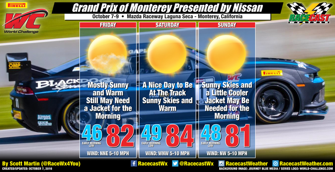
Now, on to the forecast update for the Pirelli World Challenge at Mazda Raceway Laguna Seca. Pretty much the same forecast that I gave earlier this week. High pressure is building over the area, and this will temperatures to warm nicely for today and tomorrow. An onshore flow will start on Sunday and will bring temperatures down a little, but overall, the weekend is a great one. Mostly sunny to sunny skies with highs in the low to mid 80s throughout the weekend. Rain is not expected, and all you will need is sunscreen and shades. Radar is up on the Pirelli World Challenge website, click here to go to the site, then click on link beneath our logo. By Doug Schneider Trans Am has made a good call and delayed today's official load in at Homestead-Miami Speedway to tomorrow due to Hurricane Matthew., which is now a Category 3 hurricane with maximum sustained winds near the center of 125 mph. However, Matthew's path will stay east of Homestead, so winds are expected to stay below 50 mph there later today. Here's the latest forecast track:
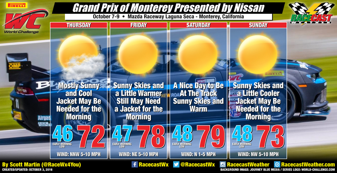
By Scott Martin As the Pirelli World Challenge visits Mazda Raceway Laguna Seca for the series' final event of the year, the weather will not be an issue. Sunny skies and nice temperatures will greet everyone when they arrive at the track.
High pressure will begin to build in near the area starting on Thursday and will persist throughout the weekend. There will probably be a few clouds hanging around during the day on Thursday, but as the high continues to build, skies will clear out for the rest of the weekend and temperatures will be warmer each day, except for Sunday. Highs will be in the low 70s for Thursday, with upper 70s for Friday and Saturday, then back into the low 70s for Sunday. Early morning lows for each day will be in the 40s, so you might want to pack a jacket for those AM sessions. No rain is expected throughout the event weekend, so overall you probably couldn't ask for better weather to end the 2016 season. I'll have forecast updates on our social media feeds and on our website throughout the week and weekend. I'll have radar set up and running on the Pirelli World Challenge website on the event page, just click on link beneath our logo. Have a great week! By Doug Schneider (Updated Tuesday 10/4 for the latest Matthew forecast)
It's going to be an interesting weather week across southeast Florida as Hurricane Matthew will be tracking near the area. The good news is that Matthew is expected to be gone by the time the on-track activity starts for Trans Am at Homestead-Miami Speedway. Here's the latest forecast track from the National Hurricane Center for Hurricane Matthew (as of Tuesday morning, 10/4), which is now a strong Category 4 hurricane with winds around 145 mph: |
Social Feeds
Authors
Doug Schneider Partners
Categories
All
Archives
December 2023
|

