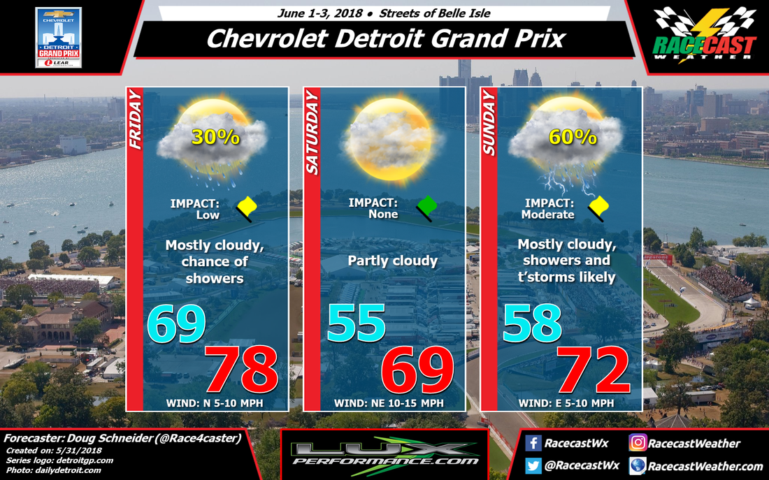
There are some differences in timing of the storms, but it appears that the afternoon will be the most likely time for storms on Sunday. That's about as precise as I can be at this time. It could be enough heavy rain and lightning in the area for some delays that will affect the day's schedule. I may have to raise the Impact level to a Red Flag, but I'm not yet confident enough on the strength and speed of the storms to do that yet.
|
By Doug Schneider The forecast confidence for Sunday as been low all week, but I had been optimistic that the chance of rain would hold off until after the race ends. That no longer looks like it will happen, as the models today have come into better agreement that a line of showers and thunderstorms will cross Belle Isle on Sunday.
There are some differences in timing of the storms, but it appears that the afternoon will be the most likely time for storms on Sunday. That's about as precise as I can be at this time. It could be enough heavy rain and lightning in the area for some delays that will affect the day's schedule. I may have to raise the Impact level to a Red Flag, but I'm not yet confident enough on the strength and speed of the storms to do that yet. By: Stephen McCoy The threat for rain looks to have cleared out for the moment for the Le Mans test day at Circuit de la Sarthe. Recent runs of the GFS and GFS ensemble models are indicating that the upper low pressure system mentioned in the previous discussion will be centered more to the east than earlier runs suggested. The resulting wind motion at the upper levels will be more from the south, bringing drier air into the region.
Winds at the lower levels and at the surface will be primarily from the east to northeast, indicating some slightly cooler temperatures, but an overall nice day for testing. By Doug Schneider The remnants of the tropical system formerly known as Alberto will be dumping quite a bit of rain across the Detroit area through tonight. The abundant moisture associated with it will exit on Thursday, so it won't interfere with the on-track activity, which begins on Friday.
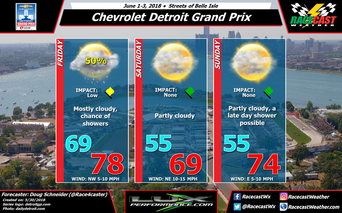
There will be a cold front passing across the area on Friday, probably around noon, followed by an upper level trough passage in the evening. With the front and upper trough in the area, the forecast continues to have a 50% chance of showers through the day, with mostly cloudy skies. I think the coverage of showers will be scattered, with a 50/50 chance of a shower hitting the track. The wind will start from the southwest in the morning, then shift to northwest once the front moves through, and increase to around 10 mph. Behind the front, high pressure will build in from the north, and provide cooler and drier air for Saturday. It looks like it will be a great day to be at the track and enjoy some racing action, with partly cloudy skies and a high temperature around 70. There will be a northeasterly breeze at 10 to 15 mph. As I mentioned in my last post, Sunday is a little more uncertain. The models are showing the high pressure system exiting and another upper level trough approaching the area, which brings some rain late in the day. At this time I think it will hold off until the evening or overnight hours, and not have an impact on the race. This may change with my next forecast update, so stay tuned. By: Stephen McCoy The 24 Hours of Le Mans is not far away now and festivities begin this weekend with the Le Mans Test Day at Circuit de la Sarthe. There are two scheduled test sessions for Sunday, one from 9:00am-1:00pm and another from 2:00pm-6:00pm local time.
An upper level low pressure system will move off the western coast of Europe, between the North Atlantic Ocean and the Celtic Sea, Saturday night into Sunday. To start test day, winds at the upper levels will be relatively calm and dry from the south, resulting in some clear skies aloft. Winds from the west to southwest will bring some moisture off the Mediterranean Sea, resulting in some partly cloudy skies. With the addition of winds from the west and southwest at the surface, expect some warmer than average temperatures during the first test session in the low-to-mid 60’s F, or in the mid-to-upper teen’s C. As the day progresses and the second test session is underway, winds in the upper levels will strengthen slightly and shift direction towards the southwest, bringing moisture off the Bay of Biscay into the area. With the addition of moisture already present in the low levels, there is a threat of scattered showers in the area and has the possibility to interfere with the second session. Overall southerly flow in the atmosphere will result in a high temperature for the day in the low-to-mid 80’s F, or upper 20’s to low 30’s C. By Doug Schneider The Chevrolet Detroit Grand Prix forecast is brought to you by Lux Performance, provider of full-service race services and custom components to both club level and professional series drivers.
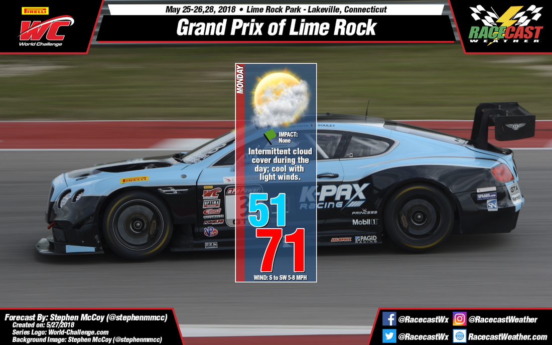
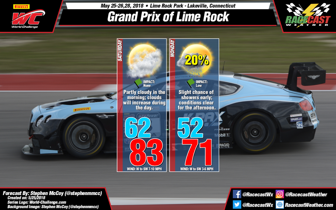
A big weekend of racing action is coming up this weekend on the streets of Belle Isle near Detroit, with IndyCar, IMSA, Trans Am, and Stadium Super Trucks all in action. After a chance of rain moves through on Friday, the weather pattern looks favorable for good conditions for racing over the rest of the weekend. The models show a cold front moving through the Detroit area sometime on Thursday night or Friday morning. There is an upper level trough that lags behind the front, which moves through later in the day. While the majority of rain will come along the front, there will still be a chance of rain in the area until the upper trough moves through. High pressure to the north over Canada will start to settle southward over the Great Lakes on Saturday, with an upper level ridge building as well. This will usher some cooler temperatures into the area, and create a pressure gradient that will produce some breezy conditions. A north wind at 10 to 20 mph and partly sunny skies will keep temperatures in the 60s for most of the day. Some differences develop in the models for Sunday regarding the strength of the ridge and whether it gives way to a weak trough. For now I'm going with a forecast that maintains the ridge, as that seems to be the way most models are pointing. With a little more sunshine expected, high temperatures should rise into the 70s. By: Stephen McCoy After a full day of racing, we’ll end Memorial Day weekend with a pair of GT and GTS SprintX races in the Pirelli World Challenge series. A low pressure system currently causing heavy rain to the upper Mid-Atlantic region will move eastward into the Atlantic Ocean overnight into Monday. As it moves off the east coast, winds in New England will shift to the northeast, bringing cooler air into the region. Wind from this direction will undercut the warm air in the region from Sunday, causing some low cloud cover and cooler temperatures in the low 50’s to start the day. With winds in the upper levels from the northwest and winds in the lower levels from the west, expect partly cloudy conditions mid-day into the afternoon. As the low pressure system continues to move further into the Atlantic, look for winds to change direction, coming from the south and southwest in the afternoon. With the winds being light, don’t expect them to help warm up the region too much, as the high temperature will be in the low 70’s.
By: Stephen McCoy Nothing much to report for Saturday; should be a good day for racing with warm conditions to start the day and a high temperature in the low 80’s. As I’ve discussed before, expect some heavier cloud cover than Friday, especially into the afternoon.
A slight chance of rain is expected during Sunday night into the early morning on Monday. Other than some possible track drying before on-track activities, I don’t see any impact to the scheduled races for Monday. Expect some cooler temperatures for the morning with light winds from the northeast off the North Atlantic; surface winds will turn to the west and southwest after midday. Winds from the northwest in both the lower and upper levels of the atmosphere will clear conditions into the afternoon and evening. The low level winds will contribute to the cooler surface temperatures for the day. |
Social Feeds
Authors
Doug Schneider Partners
Categories
All
Archives
December 2023
|

