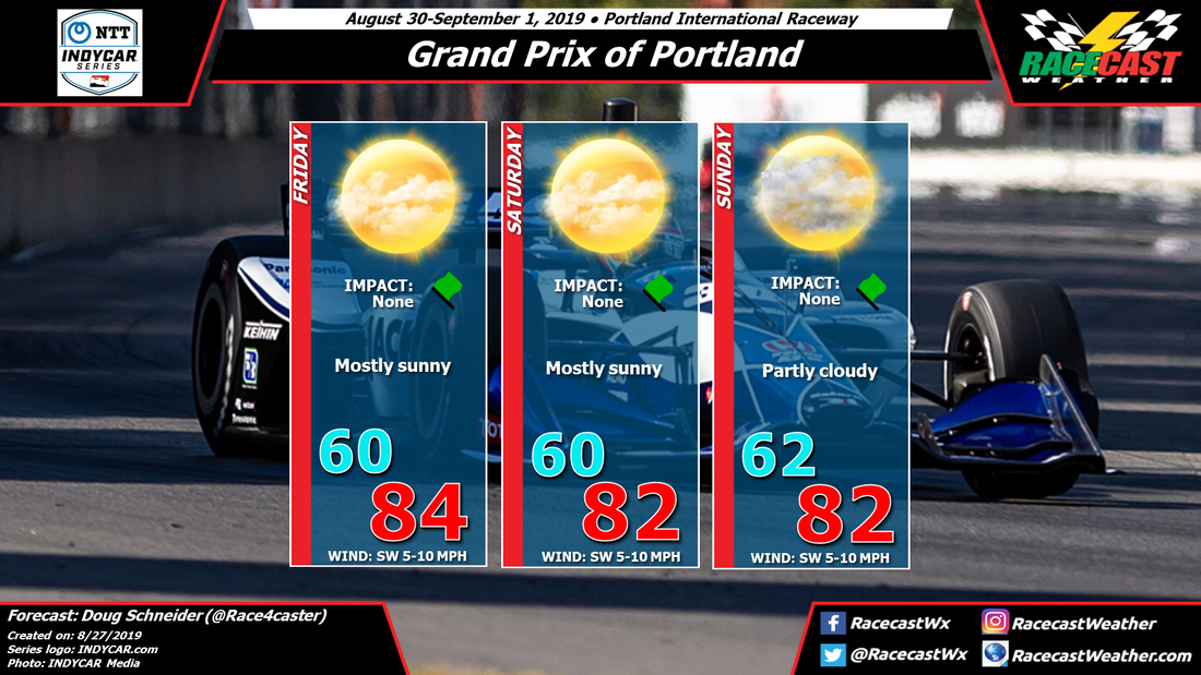
The main weather feature to affect Portland will be a low pressure system moving slowly across the Pacific toward the Northwest coastline. This will push a front through the Portland area on Saturday night. Most of the rain with this front will stay offshore or just near the coast, and rain will decrease as it moves inland. Still, there may be some sprinkles that reach Portland on Saturday night and Sunday. I don't think there would be enough rain to even measure a hundredth of an inch, if it happens at all. The front will also cause a wind shift from south of Friday and Saturday to west on Sunday.
By Doug Schneider 
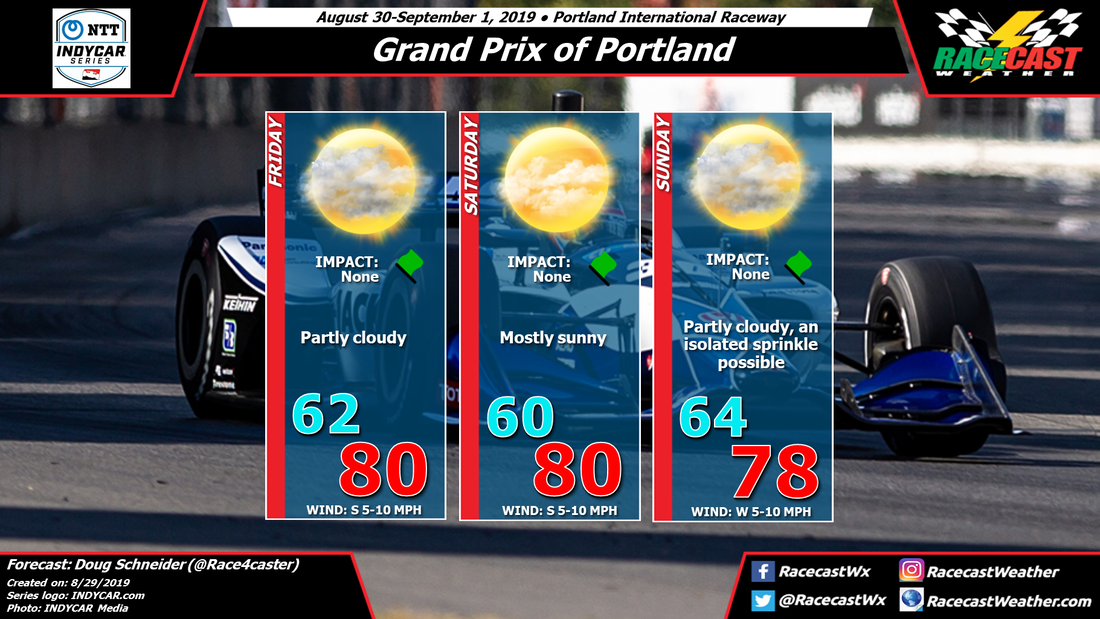
There are no major changes to the forecast for Portland this weekend, as it still looks like the weather will be nice for racing each day. There is a small chance of seeing some light sprinkles in the area on Sunday, but it should not have an impact.
The main weather feature to affect Portland will be a low pressure system moving slowly across the Pacific toward the Northwest coastline. This will push a front through the Portland area on Saturday night. Most of the rain with this front will stay offshore or just near the coast, and rain will decrease as it moves inland. Still, there may be some sprinkles that reach Portland on Saturday night and Sunday. I don't think there would be enough rain to even measure a hundredth of an inch, if it happens at all. The front will also cause a wind shift from south of Friday and Saturday to west on Sunday. By: Stephen McCoy Some minor changes in this update for Blancpain GT World Challenge America at Watkins Glen, though the general setup remains similar to the initial forecast.
A cold front from a surface low pressure system over Hudson Bay is expected to pass through the region on Friday, bringing a slight chance for isolated showers and/or light rain. West to southwesterly winds ahead of the front will cause near-average temperatures for the day. After the frontal passage, northwesterly winds will cool temperatures to the low-to-mid 50's overnight. With dew point temperatures similar to the air temperatures, there is a possibility of fog in the area Saturday morning; temperatures will rebound to the mid-to-upper 60's. High relative humidity values in the upper and lower levels will result in partly to mostly cloudy conditions through the day. A surface high pressure system will build into the region on Saturday behind the front, then move off-shore on Sunday. As it leaves the area, a stationary front is expected to setup to the north of the track, causing surface winds to shift to the south to southeast. Westerly winds in the rest of the atmosphere will bring moisture over the region, with much of the air aloft fully saturated. As a result, precipitation chances are higher than in the initial forecast; model guidance suggests the highest chance for showers near or after mid-day. By: Stephen McCoy Cool temperatures welcome the Blancpain GT World Challenge America paddock at Watkins Glen this weekend after a cold front moves through the region on Friday. The front will bring a slight chance for isolated showers, while a slim increase in chances is present on Sunday.
A surface low pressure system currently centered over western Ontario is expected to track northward through the remainder of the week. A cold front from the system will move through the mid-Atlantic region Wednesday into Thursday, resulting in a chance for rain and bringing cooler temperatures to the region. As the low moves over Hudson Bay, it is anticipated to stall, with a second cold front forming to the southwest of the center. Approaching Friday, the latter cold front will move through the northeast US, with a slight chance for isolated showers occurring along the frontal boundary. However, precipitation amounts are unlikely to be as much as the initial front due to the former utilizing most of the available moisture in the region. Southwesterly winds ahead of the front will allow temperatures to rebound into the mid-70's during the day before falling near 50 °F overnight behind the front. On Saturday, winds will shift to the northwest behind the front, causing high temperatures for the day in the mid to upper 60's. Moisture in the low levels will cause some partly to mostly cloudy conditions during the day, however high pressure and dry air at the surface will ensure no precipitation will occur. On Sunday, the high pressure system will move off the Atlantic coast, causing winds from the south to southeast. Moisture from the ocean will move in throughout the atmosphere, bringing a slight chance for showers during the day. By Doug Schneider Nice weather is expected in Portland throughout the IndyCar Grand Prix weekend.
Hot temperatures can be expected in Portland today and Wednesday, then a cold front will move across the area on Thursday, bringing a chance of showers and thunderstorms. Cooler temperatures will follow the front on Friday, and continue through the weekend. There will be a low pressure system moving across the Pacific and approaching Portland late Saturday and Sunday, but with limited moisture for this system to work with, only an increase in clouds is expected on Sunday. Each day is expected to have high temperatures in the lower to mid 80s, with a southwest wind at 5 to 10 mph. It should be a great weekend to be at the track. By Doug Schneider Good morning from VIR! I awoke to this view from my room at the Lodge - There are some isolated showers around this morning, but they likely won't have an impact. Most of the day will be partly to mostly cloudy, with temperatures reaching the mid to upper 80s.
A cold front will be moving across the area from north to south today. Showers and thunderstorms are expected to develop this afternoon, affecting the track starting around 4 pm (+/- 1 hour). The time period with the highest chance of storms is between 4 and 8 pm. Lightning and gusty winds will be the main threats from these storms, and rainfall may be heavy. Rain amounts are likely to be between a quarter and a half inch. For Saturday, with the front located across central North Carolina and continuing to push south, there will be just a 20% chance of light showers in the morning. It will be mostly cloudy and cool through the day, with a high in the lower 70s. Winds will be from the northeast at 5-10 mph. Mostly cloudy and cool conditions will continue on Sunday as high pressure to the north extends over the area. Highs will be in the upper 70s, with a northeast wind at 5-10 mph. |
Social Feeds
Instagram
Partners
Authors
Doug Schneider, Scott Martin, and Stephen McCoy are race fans and meteorologists dedicated to providing accurate forecasts and timely weather updates at racing venues around the world. We forecast for IndyCar, Indy Lights, Pro Mazda, USF2000, IMSA, Blancpain World Challenge America, and World Endurance Championship, as well as major SCCA and NASA events. Categories
All
Archives
March 2021
|