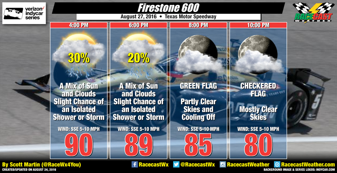
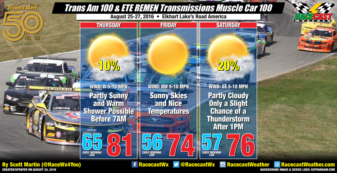
By Doug Schneider 
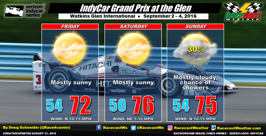
The forecast for Watkins Glen this weekend has taken a turn for the worse today due to Tropical Storm Hermine becoming a player in the weather. Hermine is currently over the Gulf of Mexico, and will track northeast across the Florida Panhandle Thursday night. What track it takes after that is highly uncertain. Over the past few days, the models have all kept Hermine well out in the Atlantic, but the latest model runs today have show a track that is much farther west, inland across the Carolinas to southern New Jersey. Here's the forecast track from the National Hurricane Center as of Wednesday afternoon:
By Doug Schneider The weather looks absolutely spectacular this weekend for IndyCar's visit to Watkins Glen. There will be a chance of rain Wednesday night and early Thursday as a cold front moves through, then high pressure will build in behind it to provide perfect racing weather. The models are all in agreement with this pattern, so I have high confidence that there will be no rain. Temperatures will reach into the 70s Friday and Saturday, and into the lower 80s for Sunday. Friday may be a little breezy, with a northwest wind at 10 to 15 mph.
For forecast updates through the week, follow me on Twitter - @Race4caster . By Scott Martin I know this will sound like a broken record, but I'm still holding to the forecast that I posted on Monday for tonight's conclusion of the Verizon Indycar Series Firestone 600 at Texas Motor Speedway. It will be a hot and humid day at the track with afternoon highs at or just over 90 degrees with a mix of sun and clouds. Still do believe that there is a slight chance for an afternoon convective shower or thunderstorm that could pop up at or near the track, but all rain chances will be zero by the time the race gets the green flag around 8:20 PM. It will be a warm and muggy night, and temperatures are expected to be near 80 degrees at 10:00 PM. Remember, if you're going to be at the track, be sure to drink plenty of water as the heat index values will be in the mid 90s to start off with a 4:00 PM.
By Scott Martin Unfortunately, the forecast has not changed from Friday's update, and Saturday looks to be a pretty wet day for the Trans Am Series at Road America.As the shortwave approaches the area between midnight on Friday night and into early Saturday morning, rain will start falling, with heavy rain and thunder at some point. The latest run of the NAM 4k model has rain and thunderstorms staying in the area throughout the morning, with the shower activity becoming more scattered in nature for the afternoon hours. Afternoon highs will be in the mid 70s, but you will definitely need umbrellas and rain parkas to stay dry. Please seek shelter in a building if you see lightning or hear thunder. We've already lost too many people in the country to lightning strikes in 2016. Let's not add to that number. Radar will be running bu the time the morning rises.
By Doug Schneider The forecast for VIR this weekend continues to look dry, but with hot temperatures. Today, highs are expected to reach into the mid 90s. Tonight, a front will push south across the area, but it will have little effect on the weather. No rain is expected as it moves through, and by Saturday, it will be south of the track across central North Carolina. Showers will develop along the front Saturday afternoon, but they should stay well south of the track. There will be a little more wind behind the front on Saturday, from the northeast at 5 to 10 mph. Race day will be mostly sunny with highs in the lower 90s, with no rain expected.
With the hot temperatures, be sure to drink plenty of water, and take frequent breaks from walking around. VIR is a beautiful track that is best experience from many locations, but there isn't much shade. Don't forget the sunscreen. This will likely be my last post and forecast graphic for VIR, as I will be at the track Saturday and Sunday. I'll be posting pictures on my Twitter account, @Race4caster. Also, we're having a NASportsCar meet up and go kart race Saturday at 5 pm at the VIR go kart track. Look for me in a NASportsCar t-shirt. |
Social Feeds
Instagram
Partners
Authors
Doug Schneider, Scott Martin, and Stephen McCoy are race fans and meteorologists dedicated to providing accurate forecasts and timely weather updates at racing venues around the world. We forecast for IndyCar, Indy Lights, Pro Mazda, USF2000, IMSA, Blancpain World Challenge America, and World Endurance Championship, as well as major SCCA and NASA events. Categories
All
Archives
December 2020
|