By Scott Martin 
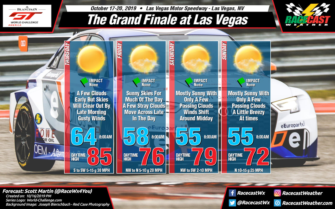
There is really not much change in the forecast for the season finale for the Blancpain GT World Challenge America series at Las Vegas. Skies will be sunny to mostly sunny throughout the entire event weekend with temperatures starting off rather warm on Thursday and becoming more mild by Sunday. Winds will be the only weather issue we'll have to deal with as we could see gusts up to 30 MPH on Thursday, 20 MPH on Friday, and 25 MPH on Sunday. With the wind, you may need a light jacked throughout the day on Friday and Sunday.
By Scott Martin You probably couldn't ask for a better forecast to end off the racing season than what looks to happen this week at Las Vegas Motor Speedway. While Friday and Saturday look nearly picture perfect with mild temperatures and plenty of sunshine, we'll have to contend with some gusty winds on the first day of practice on Thursday.
Winds will be increasing through the morning hours and will be averaging around 5-15 MPH out of the south, but gusts up to 25-30 MPH will be possible during the late morning and into the afternoon hours. Other than the wind, no weather problems should occur as skies will be sunny with no rain expected. Temperatures start off in the lower 60s at 8:00 am and warm into the mid-80s for the afternoon high. Friday and Saturday will nearly be identical in the weather department... There will be plenty of sunshine on both days with only a few passing clouds. Once again no rain in the forecast and afternoon highs will be mild. While both days will top out in the upper 70s, Friday will start off a little warmer near 60 degrees at 8:00 am with Saturday starting off in the mid-50s. Sunday looks to be a great day at the track as well as skies will be sunny with maybe a cloud or two, but we'll stay dry and mild. Temperatures start off in the mid-50s at 8:00 am and top out in the mid-70s. Winds will be out of the north at 6-12 MPH. By Doug Schneider There has been a pretty big shift in the forecast for Sunday at VIR, and it now appears that there will be a good chance of seeing rain during the day.
A cold front is expected to move into the area Saturday night, which is in line with the previous forecast thinking. However, the models are now showing this front slowing down and stalling as it moves into the Piedmont of NC and VA. It is expected to be located just southeast of VIR on Sunday. Meanwhile, an upper level disturbance will be approaching, and its interaction with this front will produce some showers in the area. Rain is possible any time of the day on Sunday, but it appears that the best chance of rain will come in the afternoon. Rain amounts in the neighborhood of a tenth of an inch can be expected. Since this isn't expected to be a heavy rainfall, and no lightning is expected, I kept the impact as low. By: Stephen McCoy A cold front moving through the region on Saturday will bring more cloudy conditions than the rest of the weekend, with slightly cooler temperatures. Surface winds are expected from the west to southwest during the morning, but will shift to the west to northwest behind the front. Temperatures will be about the same as the previous few days, but will cool behind the front; temps by the end of the race will be in the low to mid 60's. There is a slight chance for isolated showers ahead of the front near the early to mid afternoon; model output suggests maximum totals during the race around a few hundredths of an inch should precipitation occur.
By Doug Schneider The forecast that I posted on Sunday appears to be holding up pretty well as we get closer to the weekend, as there has been little change to that forecast with today's update. Nice weather is expected each day as high pressure extends across Virginia and North Carolina Piedmont region. Temperatures will be trending warmer each day through Saturday, then a cold front is expected to move across the area Saturday night.
The majority of rain with this front should pass to the north, and I'm keeping my forecast dry. However, there is a model (GFS) that shows some rain occurring Saturday night. So if there is any rain, I expect it won't affect the racing on Saturday or Sunday. With the passage of the front, temperatures will get cooler again on Sunday, with highs in the lower 70s. By: Stephen McCoy The forecast for Petit Le Mans remains mostly unchanged since the initial forecast on Sunday. East to northeasterly winds will be present during much of the weekend, bringing cooler temperatures to the region, with high temperatures in the mid to upper 70's. Winds come as a direct result of an area of high pressure at the surface extending from New England into the Mid-Atlantic and Southeast. Partly to mostly cloudy conditions are expected for much of the weekend due to low level winds bringing moisture to the region off the Atlantic. Low level and surface winds will be generally from the same direction, resulting in some slightly stronger gusts each day.
A cold front is still looking likely to pass through the region on Saturday afternoon. Precipitation chances have diminished, however moderate winds will be present ahead of the front from the south to southwest with stronger gusts possible. After the front passes, temperatures will begin to drop as winds shift to the west to northwest. By the end of the race, temperatures are expected to be in the mid-to-upper 50's. By: Stephen McCoy Warm and pleasant conditions will welcome the WeatherTech SportsCar Championship series for its season finale at Road Atlanta this weekend. The main thing of note in this forecast is the possibility of a cold front moving into the region on Saturday that could bring a slight chance for isolated showers, though at this point the models are subjective as to the location of the front.
Conditions for Wednesday, Thursday, and Friday are very similar in terms of the overall atmospheric set-up. A surface high pressure system will move into the Midwest region behind a cold front on Tuesday. The anticyclonic rotation around the system will cause winds over the Southeast to be largely from the east to northeast, slightly amplified by a possible tropical cyclone in the Atlantic. An upper level ridge will keep the surface system fairly stationary over the following days, finally relegating its influence over the region Friday into Saturday. Cloud cover on Friday may be slightly higher than earlier in the week as low level winds bring moisture from the Atlantic to the area as they are directed more from the east. Meanwhile, an upper level trough is expected to move eastwards across the US and allow a surface low pressure system to develop on the eastern side of the Rockies around mid-week. The deepening of the trough will force the system towards the Midwest Thursday into Friday with a cold front extending southwards into the Gulf of Mexico. The trough is anticipated to move over the surface low, causing it to stall over the Midwest Friday night into Saturday. However, the cold front from the system will continue to move eastward, approaching Georgia sometime during the day. The models at this point are split on when a frontal passage may occur. An earlier passage will bring a slight chance for showers during the morning and a cooler afternoon high temperature while a later passage would allow temperatures closer to those seen earlier in the week and precipitation further towards the evening. The front would also change wind direction, coming mainly from the south ahead of the front and shifting to the west to northwest behind the front. With the amount of subjectivity to the forecast this far out, it will likely change in the coming updates during the week. The SCCA Runoffs will be held at beautiful VIR this year, and the weather looks great for most of the event. Only Tuesday's qualifying sessions will have a threat of rain, and temperatures throughout the event will be very pleasant.
A cold front will pass through the VIR area on Monday, and surface high pressure will build in behind it. However, there will be an upper level disturbance that will follow the front on Monday night and Tuesday morning. This disturbance in the upper levels could bring a few scattered showers to the VIR area as qualifying begins on Tuesday, mainly during the morning hours. Any rain that falls will likely be light, maybe around a tenth of an inch all day. Through the rest of the week, high pressure will be centered over New England and southeastern Canada, extending southwest along the east side of the Appalachian Mountains. This will keep a northeast wind across Virginia and North Carolina, providing comfortable temperatures and low humidity. There will be a gradual warming trend as the weekend approaches, with highs peaking in the upper 70s on Saturday as the high loses its grip and a southwest wind develops. Another cold front is expected to cross the area on Saturday night, which will drop temperatures again for Sunday. Right now, it looks like this frontal passage will be dry, and highs on Sunday will be in the lower 70s. That is still far out in the forecast, and this front does look like it will be quite strong, so temperatures on Sunday may end up being cooler than that. Check back through the week for updates. |
Social Feeds
Authors
Doug Schneider Categories
All
Archives
February 2025
|