Racecast Weather - Your Source for Race Weather Information
  • Home
  • Racecasts
  • 2025 Schedule
  • Services
  • Contact
  • Bios
  • Links

Saturday forecast update: Honda Indy 200

7/30/2016

Comments

 
By Doug Schneider
As expected, showers and thunderstorms came through Mid-Ohio yesterday afternoon, and PWC had to cancel their GT practice and GTS Race 1. I think we'll see a similar situation today. The atmosphere over Ohio remains very moist, and there is an area of low pressure at the surface that is sitting over western Ohio, with a boundary extending east across northern Ohio. 
Picture
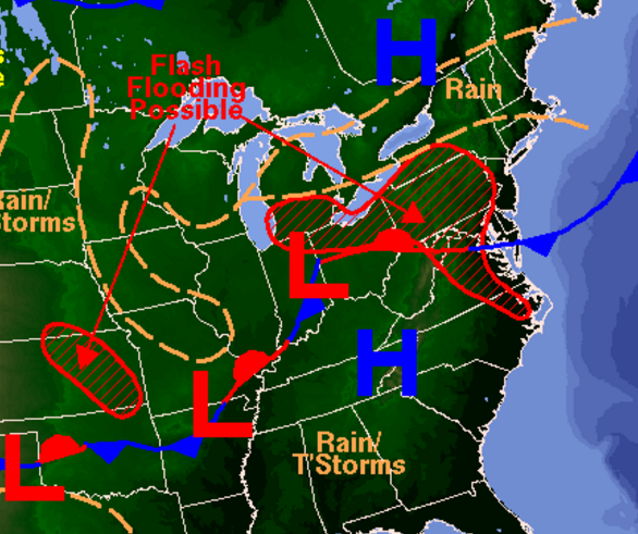
There is some sunshine at the track this morning, which will help create some instability for showers and thunderstorms to tap into this afternoon. The most likely time for storms at the track will be between 2 and 6 pm, so I think the sessions that could be affected are IndyCar qualifying, Indy Lights Race 1, PWC GT Race 1, and Pro Mazda Race 2. 

The low pressure area will be drifting east through the day, and should be over Pennsylvania tonight.  However, there will still be an upper level disturbance that will be moving through on Sunday, which will keep a slight chance of showers and thunderstorms in the forecast. It looks like areas north of the track will have the better chances of rain on Sunday, but I can't rule out an isolated shower getting near the track in the afternoon. Most of Sunday will be dry with partly cloudy skies, so I'm not too concerned about rain affecting Sunday's races. 
Comments

Thursday forecast update: Honda Indy 200

7/28/2016

Comments

 
By Doug Schneider
The forecast is coming into better focus today, Unfortunately, the chances of rain are looking higher for both Friday and Saturday. I've raised the chance of rain at the track to 60% both days. On Friday, a front will be sitting across central Ohio, while a low pressure area begins to develop along the boundary over Indiana. It looks like the best chance of rain on Friday will be late in the afternoon and evening, so the majority of on-track activity may get by without being affected by rain. Pirelli World Challenge GTS has Race 1 at 5 pm, which could potentially have wet conditions. 

On Saturday, the front and the low pressure area don't move much at all, which will keep a good chance of showers and thunderstorms at the track. Rain may be possible at any time of the day, but it looks like the best chances and the most rain will come in the afternoon. This could potentially impact IndyCar qualifying, Indy Lights Race 1, PWC GT/GTA/GT Cup Race 1, and Pro Mazda Race 2.  

The low pressure system finally starts to track east on Sunday. I think the majority of racing on Sunday will be dry, but I can't rule out at least a small chance of showers and thunderstorms as the low will continue to be close to Ohio. There should be more sunshine on Sunday than the other days. However, this sunshine could create some instability that could result in afternoon showers and thunderstorms developing.

The total amount of rainfall expected at Mid-Ohio from Friday through Sunday is between an half inch and one inch. 

If you're going to be at the track this weekend, stay aware of the weather and have a plan for finding shelter when you hear thunder. You can use the radar link at the top of our website for the latest radar image and lightning strikes.
Comments

Wednesday forecast update: Honda Indy 200

7/27/2016

Comments

 
By Doug Schneider
​I mentioned in my last post that I had low confidence in the forecast. Usually, my confidence increases as we get closer to the race weekend. But this week, that is not the case. I still don't feel very confident about this forecast. The difficulty is that there is expected to be a boundary that lingers across Ohio for nearly the entire weekend, and where this boundary sets up will determine how much rain may or may not fall at Mid-Ohio. If the boundary ends up across southern Ohio or Kentucky, then there may not be much rain at all at the track. If it is farther north, near or north of Columbus, then there could be quite a bit of rain. It is not clear exactly where this boundary will be, but since it is expected to be somewhere nearby, I have to carry at least a chance of rain every day in the latest forecast. On the bright side, the rain chances are still fairly low - a 30% chance of rain also means a 70% chance of no rain. The weekend won't be a complete washout. 

On Thursday, there will likely be a lot of rain across eastern Kentcuky, southwest Ohio, and West Virginia as a low pressure system develops in that area. Mid-Ohio is on the northern fringes of that rain area, so it will be right on the line of rain or no rain. There is some model agreement that there will be least some chance of rain, so I did bump up the probability of precipitation that day from my previous forecast.

That low pressure system will be well to the east by Friday, but there will be a boundary or weak front that is stalled across Ohio. This boundary, along with an upper level disturbance, will bring a good chance of showers and thunderstorms on Friday. Again, the amount of rain that falls will depend on where that boundary is located. I think rain amounts between a tenth and a quarter inch are the most likely scenario right now for Friday.

Saturday continues to be a big question mark. One model shows a low pressure system developing over Illinois, and tracking east across Ohio on Saturday. This scenario dumps a lot of rain over Mid-Ohio. However, no other model shows this happening, so I'm skeptical. I am going to keep the rain chance at 30% for now, given this uncertainty. 

With that pesky boundary still across Ohio, and a broad trough in the mid and upper levels of the atmosphere, I have to keep a chance of rain into Sunday. I just can't rule out that there could be some scattered afternoon showers and thunderstorms around in this unsettled pattern.

I'm sure this forecast will change again, so stay tuned for updates.
Comments

Forecast for the Honda Indy 200 at Mid-Ohio

7/25/2016

Comments

 
By Doug Schneider
IndyCar, Pirelli World Challenge, and all three of the Mazda Road To Indy series will be in action this weekend at the beautiful Mid-Ohio Sports Car Course near Lexington, Ohio. While my forecast has a chance of rain on three of the four days, note that the chance of rain is very low on Thursday and Saturday, and Sunday looks dry right now. There is a lot of uncertainty in this forecast, because the models are not in good agreement on the weather pattern. I expect that there will be some changes to this forecast over the next few days as the weather pattern comes into better focus. 

Read More
Comments

Race Day at Lime Rock Park!

7/23/2016

Comments

 
By Scott Martin
Picture
I believe that most meteorologists would get frustrated, or just downright mad, at blowing a forecast. Especially when there was a setup for the possibility for severe weather. I am so glad that my forecast was blown. Areas near the track had thunderstorms, some of which did reach severe criteria, but thank goodness they all missed Lime Rock Park.

Since that has now passed the area, Saturday's forecast for the IMSA WeatherTech SportsCar Championship and the Continental Tire SportsCar Championship events will be just simply awesome. Mostly sunny to sunny skies with afternoon highs reaching the low 90s. As the dew points are expected to be in the low 60s, the heat index will top out just above the high. Winds will be breezy out of the northwest at 10-15 MPH. Chance of rain will be zero.

It will still be a pretty warm day out there at the track. Utilize the available shade that is out there, sunscreen up, and stay hydrated. Have a great race day!
Comments

Northeast Grand Prix: Severe Storms Possible Today

7/22/2016

Comments

 
By Scott Martin.
Picture
As you can see by the image below, the Storm Prediction Center has just about the whole state of Connecticut defined in a "Slight Risk" for severe storms throughout the day today (Friday). Details are below. Saturday will be an excellent day, but very warm.
Picture
A hot and humid air mass will be over the area today, and with a frontal boundary moving through, scattered convective showers and thunderstorms will fire today into tonight. Some of the storms that develop today may become strong to severe. It is looking like the main threats of severe weather will be from damaging winds from wet microbursts, large hail, and dangerous cloud-to-ground lightning.

Good news is that the risk for Lime Rock Park to receive rain today is only 40%, so I'm crossing my fingers that the 60% chance of it remaining dry today comes to fruition. Skies will be mostly sunny to begin with, then cumulus clouds will build with the daytime heating, but will only make it partly cloudy. Highs will warm into the upper 80s, and with the dew point levels in the upper 60s to 70, heat index will reach the low to mid 90s. Stay hydrated and use common sense outside in the heat. Also, if you hear thunder, please seek shelter indoors or in your vehicle. If a storm advisory or warning is given by the track announcer, please follow their directions. Radar will be up and running today on the site. Have a great day, and stay weather aware.
Comments

Forecast Update for the IMSA Northeast Grand Prix

7/20/2016

Comments

 
By Scott Martin
Picture
Not really that much change to this weekend's forecast for the IMSA action at Lime Rock Park. I did raise the rain chance a little on Friday, as I believe a little more convective thunderstorms will fire off during the afternoon hours with the short wave that will be moving through the area. I have also backed off of the highs just a little bit as the ridging doesn't look to be as strong as first thought, and this will also keep the heat indices just below 90 (even with the high in the upper 80s, the dew points will only be at or just above 60).

Radar will be up and running on our website, and I'll have updates on both my Twitter feed and the site's feed, and on our Facebook page. Just remember to sunscreen up, wear shades and hats. Cloud cover will be limited, especially Tomorrow. Have a great day.
Comments

Forecast for the IMSA Northeast Grand Prix

7/19/2016

Comments

 
By Scott Martin.
Picture
An upper level ridge will be in control of the weather pattern throughout the weekend, which means we'll have mostly sunny to sunny skies. A short wave will add a little instability to the mix as it moves across the northeast during the day on Friday, and this will bring a chance of some isolated to scattered showers or thunderstorms during the afternoon and evening hours due to convection. After the short wave moves off the coast during the overnight hours on Friday, you can expect a very warm but beautiful Saturday.

Remember to stay hydrated and use common sense out there in the heat. With highs in the upper 80s and high humidity levels, it will be muggy and the heat index will be in the low 90s. Also remember to sunscreen up, wear the shades and hats. Cloud cover will be limited, especially on Thursday. Don't want you to get out there and get "burnt to a crisp."

Radar will be up and running on our website, and I'll have updates on both my Twitter feed and the site's feed, and on our Facebook page. Have a great day.
Comments
<<Previous

    Social Feeds


    Instagram


    Authors

    Doug Schneider
    Stephen McCoy

    Harris Cooley 


    Categories

    All
    F1
    IGTC
    IMSA
    Indycar
    Le Mans
    MRTI
    NASA
    Outlooks
    Photos
    PWC
    Racecasts
    SCCA
    SRO
    Trans Am
    TUSC
    Verification
    Weather Education
    WEC


    Archives

    June 2025
    May 2025
    April 2025
    March 2025
    February 2025
    January 2025
    December 2024
    November 2024
    October 2024
    September 2024
    August 2024
    July 2024
    June 2024
    May 2024
    April 2024
    March 2024
    February 2024
    January 2024
    December 2023
    November 2023
    October 2023
    September 2023
    August 2023
    July 2023
    June 2023
    May 2023
    April 2023
    March 2023
    February 2023
    January 2023
    December 2022
    November 2022
    October 2022
    September 2022
    August 2022
    July 2022
    June 2022
    May 2022
    April 2022
    March 2022
    February 2022
    January 2022
    December 2021
    November 2021
    October 2021
    September 2021
    August 2021
    July 2021
    June 2021
    May 2021
    April 2021
    March 2021
    January 2021
    December 2020
    November 2020
    October 2020
    September 2020
    August 2020
    July 2020
    June 2020
    March 2020
    January 2020
    December 2019
    November 2019
    October 2019
    September 2019
    August 2019
    July 2019
    June 2019
    May 2019
    April 2019
    March 2019
    February 2019
    January 2019
    December 2018
    November 2018
    October 2018
    September 2018
    August 2018
    July 2018
    June 2018
    May 2018
    April 2018
    March 2018
    February 2018
    January 2018
    December 2017
    November 2017
    October 2017
    September 2017
    August 2017
    July 2017
    June 2017
    May 2017
    April 2017
    March 2017
    February 2017
    January 2017
    December 2016
    November 2016
    October 2016
    September 2016
    August 2016
    July 2016
    June 2016
    May 2016
    April 2016
    March 2016
    February 2016
    January 2016
    December 2015
    November 2015
    October 2015
    September 2015
    August 2015
    July 2015
    June 2015
    May 2015
    April 2015
    March 2015
    February 2015
    January 2015
    December 2014
    November 2014
    October 2014
    September 2014


Powered by Create your own unique website with customizable templates.