On Sunday, dry air is expected to move in at the lower levels, in addition to the rest of the atmosphere. The result should be mostly sunny conditions, with a few light clouds. The lack of cloud cover will allow for daytime heating to warm the air at the surface, raising the temperature to the mid 70's. Surface winds are expected to be similar to the rest of the weekend, however some wind gusts around 15 mph are possible into the afternoon.
|
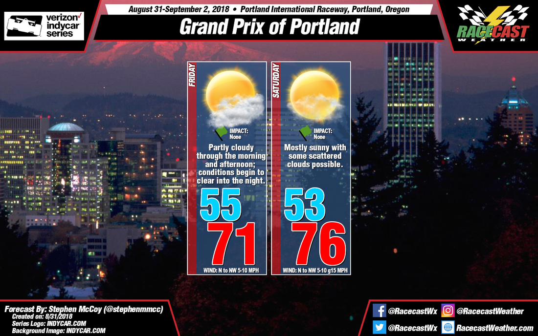
By: Stephen McCoy - @stephenmmcc Expect more sunshine and cool temperatures for the rest of the weekend at Portland International Raceway. Winds from the north to northwest will continue in much of the atmosphere, bringing dry air from Alaska and western Canada to the region. Moisture in the lower levels from the Pacific ocean will cause some partly cloudy conditions in the morning and early afternoon, but are expected to lessen as the day progresses. In recent runs, the models have trended towards cooler temperatures on Saturday, with the afternoon high only reaching the low 70's. As I've stated in the previous forecasts, the air at the surface will be dry enough to not have an effect on the heat index, with values nearly identical to the air temperature.
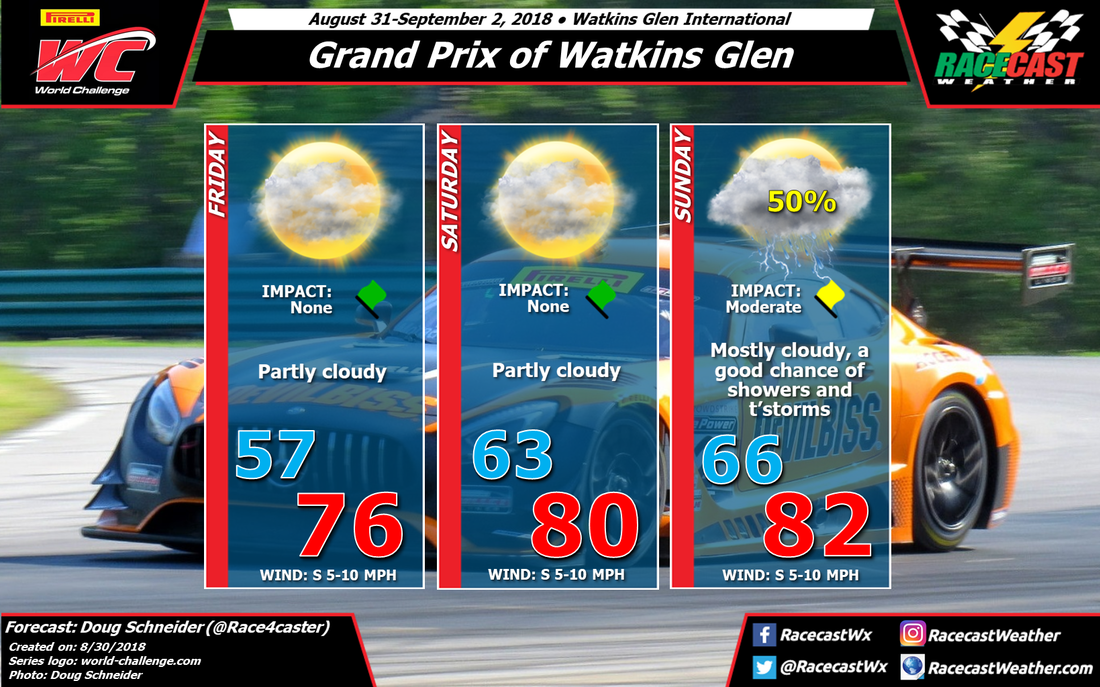
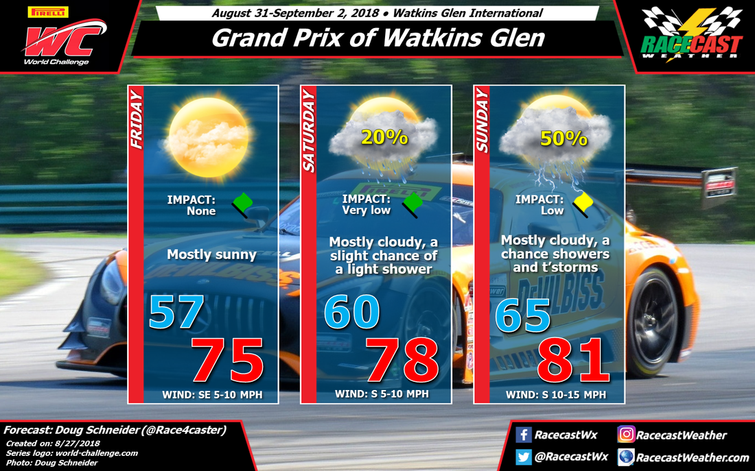
On Sunday, dry air is expected to move in at the lower levels, in addition to the rest of the atmosphere. The result should be mostly sunny conditions, with a few light clouds. The lack of cloud cover will allow for daytime heating to warm the air at the surface, raising the temperature to the mid 70's. Surface winds are expected to be similar to the rest of the weekend, however some wind gusts around 15 mph are possible into the afternoon. Not a whole lot has changed in the forecast for PWC weekend at Watkins Glen, as the models have been holding fairly steady over the past few days. However, there are still some disagreements among the models regarding the timing of rain on Saturday night and Sunday, as well as potential rain amounts. High pressure will be located over Quebec on Friday morning, and extend southward across New York. The air mass associated with this high will be quite pleasant, with high temperatures in the mid 70s and comfortable humidity levels. Some models are showing afternoon showers developing across Pennsylvania and moving north into New York, but I strongly doubt that they will make it far enough north to pose any problems for the day's practice sessions. The high pressure area continues to move east on Saturday, while a low pressure system starts to track into the upper Great Lakes region. This will bring a southerly flow that will increase the temperature a little, as well as the humidity. Despite the increase in moisture, I don't think that lift or instability will be enough to produce much shower activity in the area. I can't say the chance of rain is zero on Saturday, but I think it is low enough that I can remove it from the forecast with this update. Maybe a 5-10% chance. Rain chances start to rise on Saturday night. The models show an upper level trough tracking into far western New York Saturday evening. This should provide enough lift to bring showers into Watkins Glen on Saturday night. It is possible that some showers could linger into Sunday morning, and the morning Radical race may have to deal with a wet track. After that moves through, there should be a break in the rain chances until the afternoon when an approaching cold front will bring another round of showers. This is where the timing is still uncertain. One models shows showers and storms moving into WGI in the early afternoon, while others indicate that it will be dry until the late afternoon. I don't have enough confidence to specify the timing at this point, so showers and storms are possible at any time of the day. Rain amounts are hard to pin down at this point, as it will depend on whether a storm crosses directly over the track. Amounts between a tenth and a quarter inch are likely around the Finger Lakes region on Sunday, although a localized storm could potentially drop up to a half inch. Our radar will be running to cover WGI through the weekend - check the Radar link at the top of the page. By: Stephen McCoy - @stephenmmcc Plenty of sunshine and comfortable temperatures remain in the forecast for Indycar's return to Portland International Raceway for the Grand Prix of Portland.
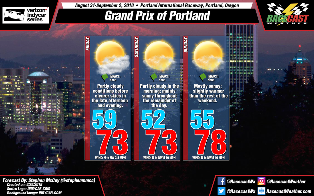
On Friday, the backside of an upper level longwave trough will be over the Pacific northwest, causing winds to carry dry air to the region from the northwest from western Canada and Alaska. Winds in the low to mid levels of the atmosphere are expected out of the west to northwest, bringing slightly more moist air from the Pacific ocean to northwestern Oregon. With dry air aloft and slightly moist air in the mid to low levels, partly cloudy conditions are likely for Friday, with cloud cover decreasing into the evening hours. Surface winds from the north to northwest will keep conditions relatively cool and dry with high temperatures reaching the low to mid 70's. With dew point temperatures around 50 degrees, the apparent temperature will be about equal to the actual temperature. Similar conditions are expected for Saturday, though with drier air moving into the region in the low levels, mostly sunny conditions are expected with some light cloud cover possible, mostly concentrated in the lower levels. Winds at the surface will remain from the north to northwest around 5-10mph, but with the addition of low level winds also from the north to northwest, there is a potential for gusts around 12-15mph. On Sunday, the jet stream in the mid and upper levels will be located over Washington and southern Canada and will continue to bring dry air to the region. Mostly sunny conditions will be likely as, in addition to the upper and mid levels, dry air is likely to move into the region at the low levels from the north to northwest. With little cloud cover, daytime heating will warm the surface, with temperatures likely reaching the mid to upper 70's. Again, with low dew point temperatures, apparent temperatures will likely be equal to the air temperatures. By: Stephen McCoy - @stephenmmcc Indycar returns to Portland International Raceway with some very pleasant weather for Labor Day weekend.
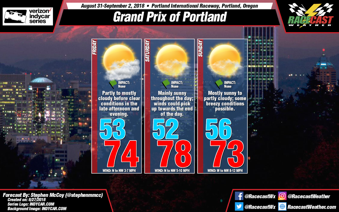
On Friday, upper level winds are expected out of the northwest as the back side of a longwave trough will be over the region; this will bring dry air and, as a result, clear conditions aloft. In the lower levels and at the surface, a high pressure system over the Pacific Ocean will direct winds from the northwest to northwestern Oregon. The air at the surface will remain dry, however moist air at the lower levels will cause some partly to mostly cloudy conditions around mid-day. With northerly to northwesterly winds at the surface, temperatures will likely reach the low to mid 70's. Conditions look similar for Saturday, except for upper level winds shifting to the west and southwest as the longwave trough continues eastward. Dry air will also move into the lower levels, causing mostly clear conditions for much of the day. Sunday shows a divergence in the models, with the GFS indicating temperatures in the mid 60's with a slight chance for showers throughout the afternoon and light, variable winds. Meanwhile, the ECMWF shows similar conditions to the rest of the weekend, with the addition of some stronger winds from the west to northwest. At this point it's difficult to forecast definitively one way or the other, but I am leaning more towards conditions remaining dry with temperatures remaining similar to the rest of the weekend. Should conditions change, they will be mentioned in the next update. By Doug Schneider The start of PWC's weekend at Watkins Glen will have really nice weather, but as a low pressure system approaches, the chance of rain will rise through Sunday.
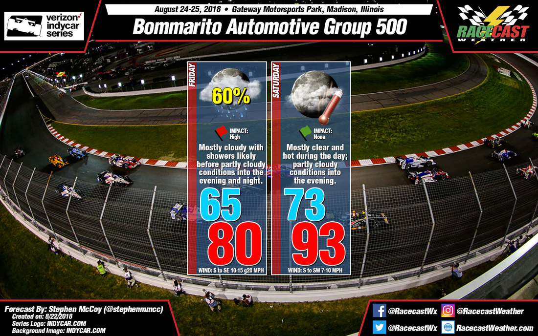
A large area of high pressure will be over Quebec on Friday, extending south into New York. It will supply dry and stable air into the Finger Lakes region, as well as pleasant afternoon temperatures in the mid 70s and low humidity. As the high continues its eastward track, winds will turn to a more southerly direction, which will start to increase the amount of moisture in the low levels of the atmosphere on Saturday. With more moisture comes more instability, and there could be a few isolated showers around on Saturday, mainly in the afternoon. If showers do form they will likely be light and brief, so the chance of rain impacting the racing is very low on Saturday. A low pressure system will be tracking across the Great Lakes region on Saturday night and Sunday, which will strengthen the southerly flow of moisture into upstate New York. Showers will be more numerous ahead of a cold front that will be trailing south of the low, and a few thunderstorms could be possible. The big question is timing, and at this point we are too far out to pinpoint that with any confidence. That should come into better focus with later forecast updates. By: Stephen McCoy - @stephenmmcc With the warm front passing on Friday, expect clear to mostly clear conditions for Saturday at Gateway Motorsports Park. Warm air at the surface is still expected to move in to the area behind the front, with moisture being brought to the region from the south to southwest off the Gulf Coast. The combination of air temperatures in the low 90's and dew point temperatures in the low 70's will raise the heat index to around 100 degrees. Winds speeds are likely to be higher as the pressure gradient at the surface looks to be stronger than in the previous forecast. In addition, some gusts could approach 20mph as the low level winds are expected from the same direction as at the surface. Race time conditions will be slightly cooler with temperatures in the mid 80's and falling as the evening progresses. However, dew point temperatures are likely to remain steadily in the low 70's, so as a result relative humidity will slowly increase; surface winds also are expected to decrease into the night.
By: Stephen McCoy - @stephenmmcc On Friday, a warm front extending from a surface low pressure system over the northern Great Plains is expected to track eastward through Missouri; the front will bring a likely chance for showers through much of the day. Breezy conditions with some stronger gusts are possible just ahead of the front as it forces winds to the north towards the center of the low pressure system. Drier air will move into the area behind the front, causing partly cloudy conditions into the evening and night. As was mentioned in the previous forecast, the timing of the frontal passage will largely determine the high temperature for the day, with an early passing creating warmer temperatures, but cooler temperatures with a later passage; for the moment, the model average indicates around 80 degrees.
On Saturday, warm air at the surface will move in behind the front, with winds from the south to southwest bringing moisture to the region from the Gulf Coast. In the upper levels, a slight high pressure ridge is expected to build in after the passage of the shortwave trough. This will trap heat at the lower levels and surface, resulting in much warmer temperatures than Friday, with highs in the low to mid 90's. With the moisture from the Gulf, dew point temperatures are expected to be in the low 70's, causing the heat index to reach or even exceed 100 degrees. Again, with the Indycar series race starting in the evening, temperatures will cool as the night progresses. Drier air in the low levels will keep conditions partly cloudy through much of the day. One thing to note for Saturday is there is a slight chance for scattered showers in the mid morning to early afternoon, but there should be no impact to the day's races. However, if there is a trend towards showers occurring later in the day, it will be noted in the next forecast update. By Scott Martin Friday continues to look to be rather wet at Road America as showers and thunderstorms look to be likely throughout the day. Skies will be mainly cloudy with afternoon highs topping out in the upper 60s. Winds will be gusty at times out of the south averaging 10-15 MPH with gusts up to 25 MPH at times. Rainfall amounts through the day could total up to 1/4 to 1/2 inch. Rain chances are up to 70%.
Some stray showers may linger around on Saturday morning, but all rain chances should have diminished before the noon hour. Clouds will be decreasing and skies will be mostly clear by the mid-afternoon hours. It will still be a little breezy with winds out of the west at 10-15 MPH. Afternoon highs will top out around 80 degrees. The chance of rain during the morning hours will be around 20%. Unfortunately, rain chances seem to be returning into the forecast for Sunday, but the good news is that it looks to be scattered in nature. The morning should remain dry with a small chance of scattered showers and storms after the noon hour. Clouds will be on the increase and afternoon highs will be in the mid-80s. Chance of rain starts off a 0% during the morning, but increases to 30% after 12:00 PM. |
Social Feeds
Authors
Doug Schneider Partners
Categories
All
Archives
December 2023
|

