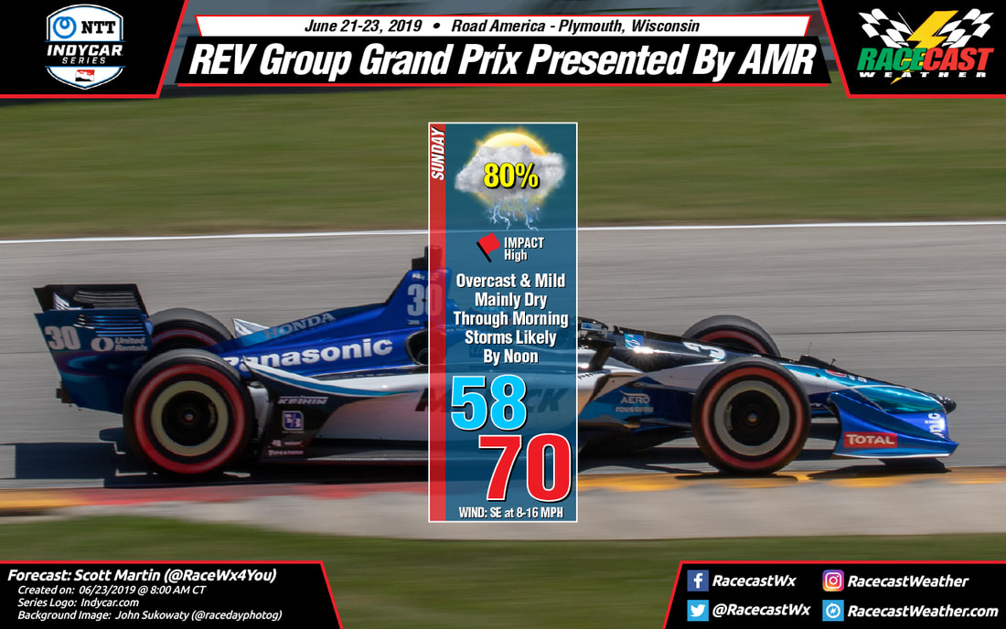
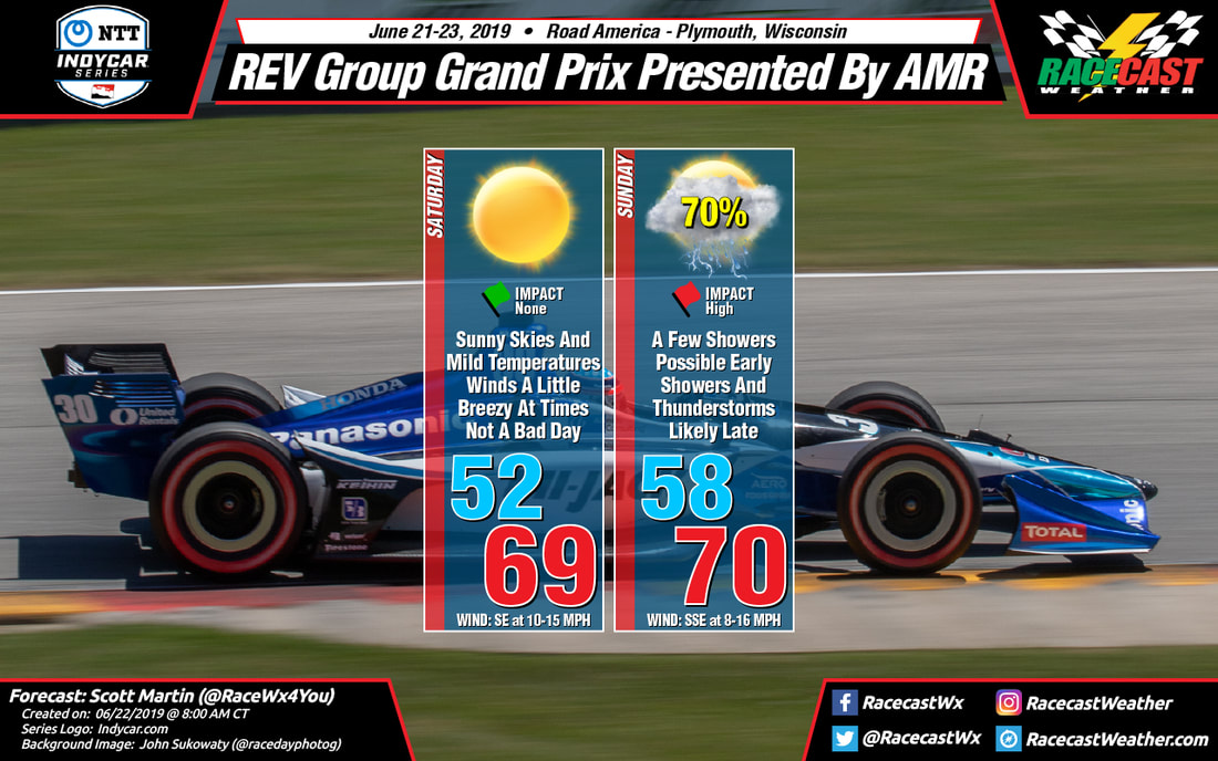
Racecast Weather - Your Source for Race Weather Information
  • Home
  • Racecasts
  • 2023 Schedule
  • Services
  • Contact
  • Bios
  • Links

Friday forecast update for Sahlen's Six Hours of the Glen

6/28/2019

Comments

 
By Doug Schneider
Picture
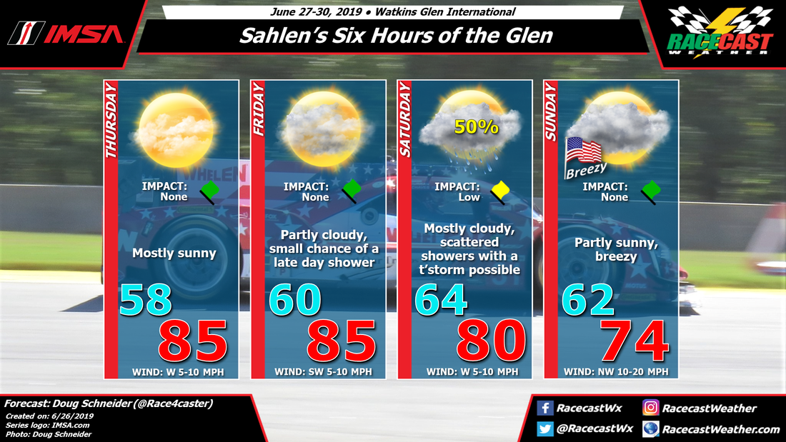
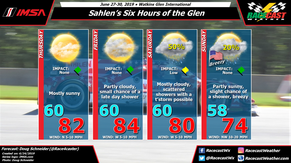
So far the weather is playing out as expected at Watkins Glen. Today has been a sunny day with warm temperatures. There is some rain currently moving across southern Ontario, but it is not expected to arrive at the track until after sunset. This area of rain is associated with an upper level trough that will cross Watkins Glen tonight, and it will probably only produce a tenth of an inch of rain or less. I expect that it will be gone before on-track activities start on Saturday morning. 

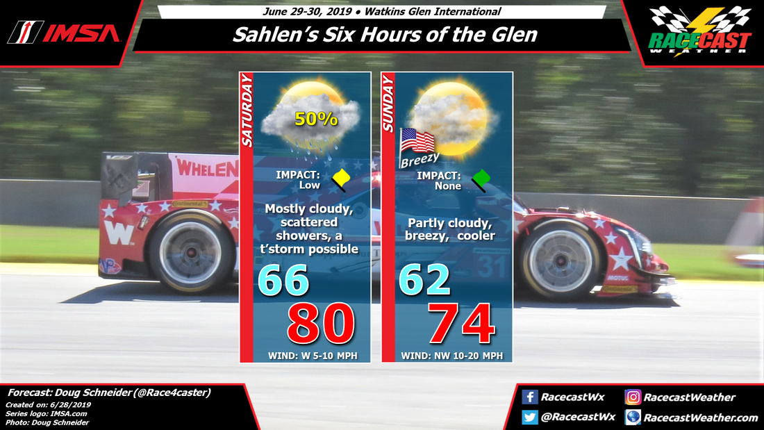
However, there will be a cold front approaching the area later on Saturday, which could bring another chance of rain in the afternoon. There is still some uncertainty about this round, as the models disagree on the location of where storms will develop in the afternoon and the speed of the front. One models that is faster with the front (NAM) keeps showers south of the area, mostly in Pennsylvania, while another is slower (GFS) and develops showers right over the Finger Lakes area. I am going to keep my forecast of scattered showers going unchanged. It's probably a 50/50 shot at seeing rain at the track on Saturday. If a shower does pass over the track, between a tenth and a quarter inch of rain can be expected, and there may be lightning in the area which could cause a brief delay. 

By sunset Saturday, the front should be through the area, and winds will shift to the northwest, Cooler temperatures will follow on Sunday, with partly cloudy skies and highs in the mid 70s. It should be a nice day to enjoy the Six Hours. There will be a good breeze from the northwest at 10 to 15 mph most of the time, with gusts to around 20 mph at times.
Picture
Comments

Forecast update for Pikes Peak International Hill Climb

6/27/2019

Comments

 
By: Stephen McCoy
Picture
Conditions haven't changed much since the initial forecast for Sunday with minor changes in temperatures and no changes to the winds in this update. However, chances for showers are increasing for mid-day Sunday into the afternoon. Recent model runs have been in agreement with each other; all global models indicate some amount of precipitation occurring during the day. The NAM 3km model, which is a higher resolution model and can model the terrain better, doesn't help the case for dry conditions: CAPE values are approaching 1000 J/kg which will help to create unstable conditions for the region.

The atmospheric set-up hasn't varied much from the initial forecast as upper level winds will be from the southwest ahead of an upper level trough. Moisture in the upper levels is expected to cause some partly to mostly cloudy conditions on Sunday morning to mid-day. An area of low pressure is anticipated to form to the eastern side of the Rockies during the day. Cyclonic rotation around the low will result in winds from the east to southeast which will transport air from the Great Plains to the region. Orographic lifting will cause the air to condense as it moves up the mountainous terrain, allowing scattered showers to occur through the region, with some thunderstorms possible. As I mentioned in the initial forecast, the conditions discussed here are for the start line of the hill climb, so conditions could vary at the top of the mountain, namely temperature, cloud cover, and precipitation.
Comments

Wednesday forecast update for Sahlen's Six Hours of the Glen

6/26/2019

Comments

 
By Doug Schneider
Picture
The forecast that I posted on Monday for the Sahlen's Six Hours of the Glen still looks on track today, with only a few small changes needed with today's forecast update. I have been watching the models the past few days regarding the possibility of rain arriving on Friday, and I'm glad to report that I can keep a dry forecast that day. Sunday is also looking drier, as I have removed the slight chance of showers from the previous forecast.

On-track sessions begin on Thursday, and the weather looks great, although on the warm side, with plenty of sunshine and high temperatures in the mid 80s. Friday will have a little more clouds cover but with a southwest wind, temperatures will rise into the mid 80s again in the afternoon. There could be a very light and brief shower at the track before sunset Friday, but I think the chances of this occurring are less than 20%, and even that small chance would come after the day's on-track sessions are done. 

A low pressure system will be over eastern Canada, tracking south-southeast through the weekend. This will push a cold front toward Watkins Glen, probably sometime on Saturday. Showers ahead of this front may arrive as early as Friday night. There is still some disagreement among the models regarding the timing of the best rain chances, so I don't feel confident enough yet to be more specific on timing. Scattered showers are possible at any time on Saturday, with a small chance of a thunderstorm.

The cold front is expected to be through the area by the end of the day Saturday, shifting winds to the northwest and bringing an end to any showers. The upper level low pressure system will be to the east, over New England, and the northwesterly flow will bring drier and cooler air on Sunday. Temperatures will be cooler with a northwest wind between 10 and 20 mph and a good amount of clouds around, but with some partial sunshine, highs will reach the mid 70s. 

Here's the forecast graphic in Celsius, if you're into that sort of thing.
Picture
Comments

Initial forecast for Pikes Peak International Hill Climb

6/24/2019

Comments

 
By: Stephen McCoy
Picture
Much like Doug mentioned in his initial forecast for this event last year, this area can prove tricky to forecast for since conditions can vary greatly in a relatively small area. This forecast in the graphic is for the start line at the bottom of the hill climb. Conditions (namely temperatures) will likely be much cooler at the peak than shown in the graphic.

Overall conditions for the weekend will be partly to mostly cloudy with most clouds concentrated in the upper levels on Saturday and in the (relative) low and upper levels on Sunday. The cloud cover will come as a result of moisture from the southwest as a longwave upper level trough slowly approaches from the west. A stationary area of low pressure at the surface is expected to the east of Colorado Springs, in the leeward side of the Rocky Mountains on Sunday This low will cause winds from the east to northeast over the region. Orographic lifting will allow air at the surface to rise and condense as it moves vertically up the mountain range. The addition of daytime heating will result in a chance of showers with thunderstorms possible Sunday afternoon.
Comments

First Forecast for the Sahlen's Six Hours of the Glen

6/24/2019

Comments

 
By Doug Schneider
Picture
High pressure over the Pennsylvania and upstate New York areas will provide nice weather as practice sessions begin on Thursday at Watkins Glen International. That should continue for most of Friday as well, but there are some models that are developing some pop-up showers late in the day. I'm not very confident that this will happen or have any impact on the racing, so I'm keeping the rain icon out of the graphic for now. The chance of rain during the day on Friday is less than 20%. 

On Saturday a cold front will be approaching the area from the north, which will bring a better chance of showers. The timing is too uncertain to pinpoint this far out, but the coverage of showers appears to be scattered at this time, so I do not expect it to be a persistent all-day rain - passing on/off showers are more likely. The impact on the racing should be low, which means that all scheduled events should be able to be completed. 

The front should be through the area by Sunday morning, but there will still be an upper level trough over the region. Under this trough, there could be some light showers in the Watkins Glen area, but most of the activity should stay to the east, near Albany. I'm uncertain enough about the location of the showers that I am putting in a 20% chance of rain, but I don't think it will have an impact. Temperatures will be cooler and winds will be stronger on Sunday. 

​Check back through the week for updates to the forecast.
Comments

Sunday Morning Forecast Update For Road America

6/23/2019

Comments

 
By Scott Martin
Picture
Looking at the latest high-resolution models and radar trends this morning, I do believe that we stay mainly dry through the morning hours at Road America, but those thunderstorm chances really begin to ramp up around 12:00 pm. I wouldn't be surprised if there is a passing light shower during the morning hours, but chances will be rather small. If there is a delay today due to storms, it may only be for a couple of hours as we may have a mainly dry slot around 3:00 PM-4:00 PM. A passing shower or two is possible but they should be light in nature. Afternoon high tops out around 70 degrees. Winds will be out of the southeast at 8-16 MPH. Rain chances during morning: 20%-30%. Rain Chances from 12:00 PM-3:00 PM: 80%. Rain chances after 4:00 PM: 30%-40%.
Comments

Saturday Forecast Update For Indycar At Road America

6/22/2019

Comments

 
By Scott Martin
Picture
So sorry for the lack of forecast updates for the past couple of days. Severe storms have kept me busy in my hometown.

No problem at all with the weather at Road America as skies will be sunny. Temperatures will be mild topping out in the upper 60s just below 70 degrees. Winds will be out of the southeast at 10-15 MPH.

Sunday may be a different story... we'll have a few showers possible during the morning hours but rain chances greatly increase as we move into the late morning and afternoon hours. Showers and thunderstorms will be likely after 12:00 pm. I'm crossing my fingers that the heavier showers and storms hold off until well later in the afternoon. The afternoon high will top out right around 70 degrees. Chance of rain is at 70%.

I'll have radar up and running within the next hour or so. Have a great day!
Comments

Race day forecast for the ADAC TOTAL 24 Hours of Nürburgring

6/21/2019

Comments

 
By: Stephen McCoy
Picture
Picture
Race day conditions remain as forecast in previous updates for the ADAC TOTAL 24 Hours of Nürburgring. One thing to note is that the high temperature for Saturday will be in the low 20's C, or upper 60's F. The high temperature is expected around 4-5 PM local time and is not featured in the graphic. According to timeanddate.com moon-rise will be at 1:07 AM, being visible for a few hours before sunrise on Sunday.
Comments
<<Previous

    Social Feeds


    Instagram


    Authors

    Doug Schneider
    Scott Martin
    Stephen McCoy

    Harris Cooley 


    Partners

    Picture
    Picture
    Picture
    Picture
    Picture

    Categories

    All
    F1
    IGTC
    IMSA
    Indycar
    Le Mans
    MRTI
    NASA
    Outlooks
    Photos
    PWC
    Racecasts
    SCCA
    SRO
    Trans Am
    TUSC
    Verification
    Weather Education
    WEC


    Archives

    March 2023
    February 2023
    January 2023
    December 2022
    November 2022
    October 2022
    September 2022
    August 2022
    July 2022
    June 2022
    May 2022
    April 2022
    March 2022
    February 2022
    January 2022
    December 2021
    November 2021
    October 2021
    September 2021
    August 2021
    July 2021
    June 2021
    May 2021
    April 2021
    March 2021
    January 2021
    December 2020
    November 2020
    October 2020
    September 2020
    August 2020
    July 2020
    June 2020
    March 2020
    January 2020
    December 2019
    November 2019
    October 2019
    September 2019
    August 2019
    July 2019
    June 2019
    May 2019
    April 2019
    March 2019
    February 2019
    January 2019
    December 2018
    November 2018
    October 2018
    September 2018
    August 2018
    July 2018
    June 2018
    May 2018
    April 2018
    March 2018
    February 2018
    January 2018
    December 2017
    November 2017
    October 2017
    September 2017
    August 2017
    July 2017
    June 2017
    May 2017
    April 2017
    March 2017
    February 2017
    January 2017
    December 2016
    November 2016
    October 2016
    September 2016
    August 2016
    July 2016
    June 2016
    May 2016
    April 2016
    March 2016
    February 2016
    January 2016
    December 2015
    November 2015
    October 2015
    September 2015
    August 2015
    July 2015
    June 2015
    May 2015
    April 2015
    March 2015
    February 2015
    January 2015
    December 2014
    November 2014
    October 2014
    September 2014


Powered by Create your own unique website with customizable templates.