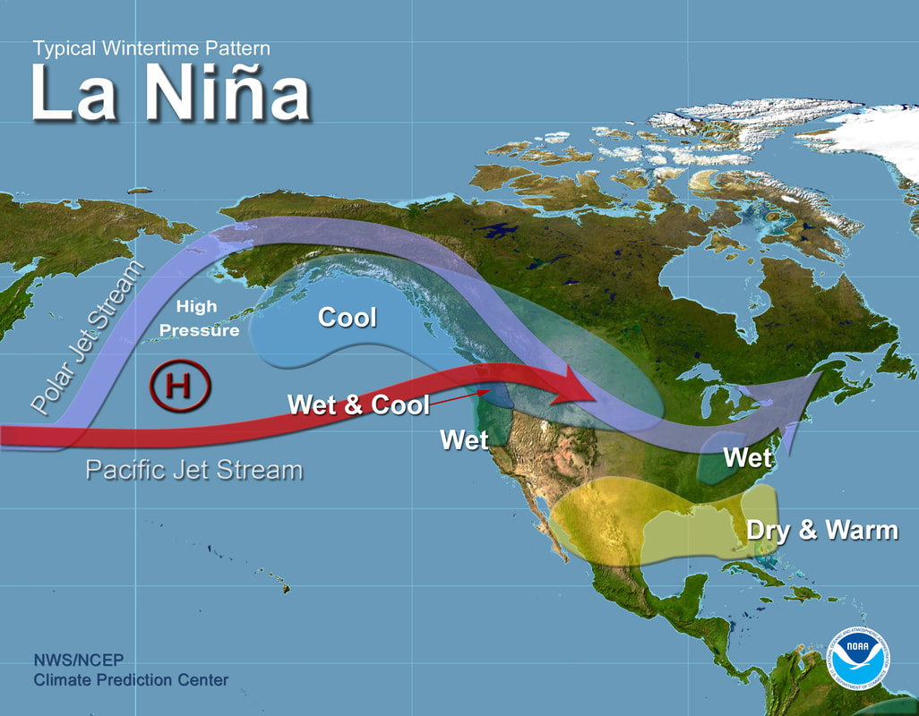
Racecast Weather - Your Source for Race Weather Information
  • Racecasts
  • Radar
  • 2018 Schedule
  • Links
  • Bios
  • Contact

Long term weather outlook for Florida through March

12/29/2017

3 Comments

 
By Doug Schneider - @Race4caster

​
The start of the 2018 racing season is almost here! The seasons for IMSA, NASCAR, Trans Am, Pirelli World Challenge, and IndyCar all open in the state of Florida during January, February, and March. So I decided to take a look at what the long term weather outlook is for those months. 

A couple years ago, I wrote a post about long term weather forecasting, and I encourage you to take a look at that to get a better idea of what goes into making a long term forecast, and what the limitations are. It's foolhardy to try and pinpoint specific details about the weather more than 10 days in advance, but it is possible to predict the general weather pattern and the likelihood of temperature and precipitation being above or below normal. The Climate Prediction Center has forecasters that make monthly and seasonal forecasts, and I will be using their forecasts here. 

One important factor in making a long term forecast is to know what the ENSO cycle will do. What's ENSO, you ask? It stands for El Niño-Southern Oscillation (for more information about it, see this post). Whether there is an El Niño or a La Niña in the Pacific will have an impact on the dominant position of the jet stream, which impacts the weather pattern across North America. Currently, La Niña conditions are observed in the Pacific, which is expected to persist through the winter. 

What does that mean for Florida? Typically, La Niña conditions produce warmer-than-normal temperatures and drier-than-normal conditions across Florida during the winter:
Picture
As a result of the La Niña conditions likely continuing through March, the forecasters at the Climate Prediction Center are expecting temperatures above normal (left image) and precipitation below normal (right image) for Florida in the Jan-Feb-Mar time frame (click it to big it):
Picture
Picture
The color scales at the bottom of the images are essentially confidence levels. So for example, the more confident the forecaster is that below normal precipitation will occur for those three months, the higher the probability on the color scale (darker brown). Daytona is the the 40-50% probability area for above normal temperatures, and in the 50-60% probability area for below normal precipitation.

Here's another way to think of it. There are three equal possibilities - conditions near normal, above normal, or below normal. So this is what the forecast above looks like visualized as a pie chart for Daytona:
Picture
 - Visually, that makes more sense to me. Of the three possible outcomes, the most likely is that temperatures will be above normal (42% chance), and precipitation will be below normal (59% chance). 

While this forecast is no guarantee of warm and dry race weekends, I'd say it is good news for race fans who plan to attend these events in Florida. Keep in mind that this forecast covers a period of three months, and the five race weekends (Rolex 24, Daytona 500, TA at Sebring, 12 Hours of Sebring, GP of St. Pete) are only 10 days out of 90. So those 10 days could all be cold and rainy, while the other 80 days could be warm and dry, and the long term forecast for Jan-Feb-Mar would still be accurate. But there would be a lot of unhappy race fans.

We'll have the detailed forecasts for these races (except the Daytona 500 - we leave that to @NASCAR_WXMAN) posted here at RacecastWeather.com a week before the race is run. You can see our entire schedule of race forecasts at the 2018 Schedule link at the top of the website, and be sure to follow all of our social media feeds - we're on Twitter, Facebook, and Instagram. 
3 Comments

Weather Safety 101: Tornadoes

2/27/2017

0 Comments

 
By Scott Martin.
Picture
Living in Central Alabama, I am no stranger to tornadoes. Within the last six years, a tornado has touched down and moved within 1 mile of my house. One of those tornadoes was the April 27, 2011 event. The tornado moved through the city of Tuscaloosa and made a b-line towards downtown Birmingham. As I was watching the tornado ripping people's property to shreds, I noticed that its current path would bring it to my neighborhood. The tornado made it to within 1 mile of my house before it changed direction and moved just south of us. We were very fortunate that we only had to clean up debris that fell out of the sky, but you know the rest of the story.

I have always been a weather fanatic, or nerd, since I was a small child. This single event is what got me fired up to become a meteorologist, so I can help make a difference in keeping people safe during severe weather. Now let's get to the topic at hand.

A tornado is a violently rotating column of air usually descending from thunderstorms that makes contact with the ground. Wind speeds with a tornado can be as week as 65 MPH, but can reach upwards of 200 MPH and beyond. The fastest wind speed ever recorded in a tornado was 318 MPH, one that hit Moore Oklahoma back in 1999.

Tornadoes come in all shapes and sizes... In the Plains, most tornadoes are easy to see with low precipitation being involved and plenty of open spaces with hardly any obstructions. In the southeast, they are usually hard to see because they are rain-wrapped or hidden by the terrain. Either way, your safety depends on being constantly aware during severe weather events.

Understanding Tornado Alerts
What is the difference between a Tornado Watch and a Tornado Warning issued by the National Weather Service?
  • A Tornado Watch means that tornadoes are possible in and near the watch area. Be ready to act quickly if a warning is issued or if you believe a tornado is approaching.
  • A Tornado Warning means a tornado has been sighted or indicated by radar. Take action! There is imminent danger to life and property.
Tornado watches are issued by the Storm Prediction Center. The area of a watch is typically large, covering numerous counties or even states. Warnings are issued by your local forecast office. Warnings encompass a much smaller area, usually including parts of parts of a few counties at most. Warnings are issued when a tornado is observed by a person on there are definite signs on radar.

What To Do During A Tornado
Be prepared! Acting quickly is key to minimizing impacts and staying safe.
  • Stay Weather Aware: During a severe weather threat, pay close attention to your reliable sources of watches and warnings and be ready to act in case a warning is issued.
  • In Your Home: If a tornado warning is issued for your location, go to your basement, safe room, or an interior room on the lowest floor, away from windows. Get under something sturdy. Put on a helmet if possible.
  • At Work or School: Proceed to the designated shelter area. Stay away from windows and do not go to large open rooms such as auditoriums, cafeterias, or gymnasiums.
  • Outdoors: Seek shelter inside a sturdy building immediately. Sheds and storage facilities are not safe.
  • In A Vehicle: You are not safe at all inside a vehicle during a tornado. Drive to the substantial structure and go inside. If one is not available, stay in the car, buckle up and get down OR seek shelter in a low lying area such as a ditch or ravine.
Picture
​What To Do After A Tornado
  • Stay Informed: Continue to listen to local television or radio coverage or NOAA Weather Radio to stay updated about tornado watches and warnings. Multiple rounds of thunderstorms capable of producing tornadoes are possible during severe weather outbreaks.
  • Contact Family and Loved Ones: Let your family and close friends know that you’re okay so they can help spread the word. Text messages or social media are more reliable forms of communication than phone calls.
  • Assess The Damage: After the threat for tornadoes has ended, check to see if your property has been damaged. When walking through storm damage, wear long pants, a long-sleeved shirt, and sturdy shoes. Contact local authorities if you see power lines down. Stay out of damaged buildings. Be aware of insurance scammers if your property has been damaged.
  • Help your Neighbor: If you come across people that are injured and you are properly trained, provide first aid to victims if needed until emergency responders arrive.
Don’t disregard severe thunderstorm warnings because severe thunderstorms can produce tornadoes with little or no advance notice.
0 Comments

Weather Safety 101: Severe Thunderstorms

2/22/2017

0 Comments

 
By Scott Martin.
Picture
This week is Severe Weather Awareness Week in the state of Alabama, and since you haven't seen a post by me on this blog in quite a while, I thought I would share some Weather Safety 101 with you.

Many find storms to be interesting and even thrilling, but they are dangerous creatures that deserve our respect. By definition, thunderstorms contain lightning, the underrated killer. Thunderstorms also produce damaging winds, hail, flooding and tornadoes. For a storm to be considered “severe”, it must contain at least one of the following criteria:
  • Wind gusts of 58 MPH or greater
  • Hail of 1 inch in diameter or greater
  • A tornado

Although lightning can be deadly, the National Weather Service doesn’t use it to define a severe thunderstorm. If it did, every thunderstorm would be severe, by definition. Also, excessive rainfall may lead to deadly flash flooding, but heavy rain is not considered severe. Flood threats are handled through a separate set of watches and warnings from the NWS Birmingham. And there are tornadoes... yes these do make a thunderstorm severe, but they will be upgraded to a tornado warning by the NWS if that happens.

One event that can cause damage and injuries during severe thunderstorms are straight line winds. Damaging winds occur much more frequently than tornadoes and can be just as damaging. They can exceed 100 mph. Trees and power lines can be knocked down, mobile homes can be overturned, and well built homes and buildings damaged.

Another event that can cause damage and injuries during severe thunderstorms is hail. Hail is most common in the spring in Alabama, when atmospheric conditions make it most likely that the ice can reach the ground. Hail can cause severe damage to automobile and even to buildings, damaging roofs and windows. Hail injuries are rare, but do happen. Hail can also cause deaths, as happened on March 28, 2000 when a man in Fort Worth, Texas was struck by a baseball sized hailstone. There have been five recorded hail fatalities in U.S. history. So while it is not a frequent killer, it can still be deadly. To be safe, just don’t get caught outside in a thunderstorm.

Tornadoes are another event that can happen during severe thunderstorms. We’ll cover in another Weather Safety 101 post.

The primary safety rule for dealing with thunderstorms is to be in a well built structure, away from windows. This will protect you from the hail and non-tornadic winds. Also avoid any electrical equipment. If you are caught outside, find shelter immediately.

Stay tuned for another Weather Safety 101 post soon.
0 Comments

Return of the polar vortex

12/14/2016

0 Comments

 
By Doug Schneider

Over the next few days, you're probably going to hear the term "polar vortex" quite a bit, especially if you live in the northeast sections of the United States. I've seen a few scary-sounding headlines (much like we see with El Nino) that make it sound like Polar Vortex will come rolling into town and wipe out everything in its path.
Picture

Read More
0 Comments

What to do if you are caught outdoors when lightning approaches

4/12/2016

0 Comments

 
By Doug Schneider

I ran across this graphic today that shows what you should do if you are caught outside when lightning is nearby. Of course, the best option is to find shelter. But at race tracks, that is often not an option for everyone. If you have no other choice, this is the position that will give you the best chances of surviving a lightning strike. (H/T - Mike Smith Enterprises Blog)
Picture
0 Comments
<<Previous

    Social Feeds


    Instagram

    Instagram

    Partners

    Picture
    Picture
    Picture
    Picture
    Picture

    Authors

    Doug Schneider and Scott Martin are race fans and meteorologists dedicated to providing accurate forecasts and timely weather updates at racing venues around the world. We forecast for IndyCar, Indy Lights, Pro Mazda, USF2000, IMSA, Pirelli World Challenge, World Endurance Championship, and Trans Am Series races, as well as major SCCA and NASA events.


    Categories

    All
    F1
    IMSA
    Indycar
    Le Mans
    MRTI
    NASA
    Outlooks
    Photos
    PWC
    Racecasts
    SCCA
    Trans Am
    TUSC
    Verification
    Weather Education
    WEC


    Archives

    April 2018
    March 2018
    February 2018
    January 2018
    December 2017
    November 2017
    October 2017
    September 2017
    August 2017
    July 2017
    June 2017
    May 2017
    April 2017
    March 2017
    February 2017
    January 2017
    December 2016
    November 2016
    October 2016
    September 2016
    August 2016
    July 2016
    June 2016
    May 2016
    April 2016
    March 2016
    February 2016
    January 2016
    December 2015
    November 2015
    October 2015
    September 2015
    August 2015
    July 2015
    June 2015
    May 2015
    April 2015
    March 2015
    February 2015
    January 2015
    December 2014
    November 2014
    October 2014
    September 2014


Powered by
✕