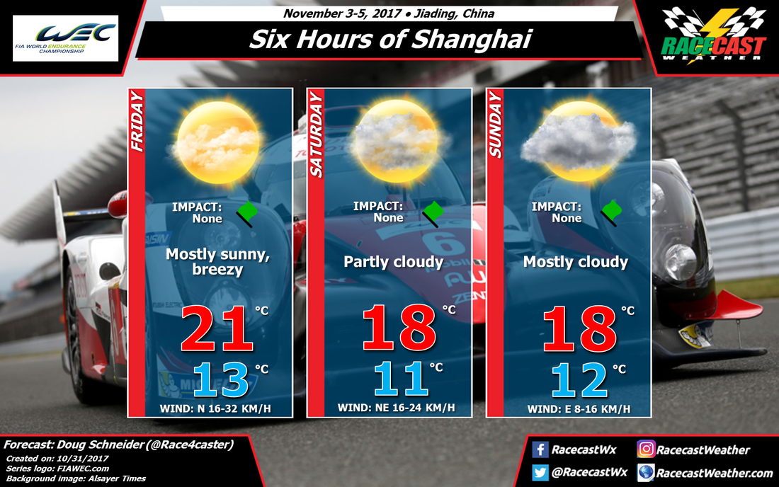
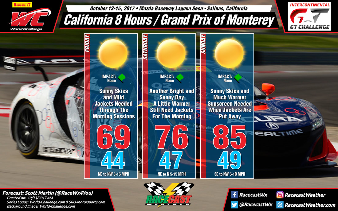
Racecast Weather - Your Source for Race Weather Information
  • Racecasts
  • Radar
  • 2021 Schedule
  • Links
  • Bios
  • Contact

Forecast For Round 12 Of The Trans Am Series At COTA

10/30/2017

 
By Scott Martin - ​@RaceWx4You
Picture
Not a bad looking weekend out in Austin, Texas for this weekend's Trans Am Championship presented by Pirelli action at Circuit of the Americas. Warm temperatures can be expected throughout the event weekend, along with mild mornings, and dry conditions. A high pressure center will develop over northern Mexico, and this will allow for a southwesterly flow bringing in warmer air from south of the border. No rain is expected throughout the event weekend, but be sure to bring your hats, shades, and plenty of sunscreen. Highs will be in the 80s with early morning lows in the 60s. This would be nearly perfect weather for the summer, but pretty warm as highs will be nearly 10 degrees warmer than average for early November. Be sure to stay hydrated.

Forecast for the WEC 6 Hours of Shanghai

10/30/2017

Comments

 
By Doug Schneider
Picture
Picture
A large high pressure system is expected to be the main weather feature throughout the 6 Hours of Shanghai weekend, which should provide nice weather conditions each day. The high pressure center starts out to the northwest of Shanghai on Friday, and as it builds in behind an exiting front, it will be breezy, with a north wind at 10 to 20 mph. The high shifts east through the weekend, and as it moves toward the Korean Peninsula and Japan, it will turn winds to the east. This will bring some moisture off the ocean - enough to increase cloud cover on Saturday and Sunday, but likely not enough to produce rain as the moisture should be shallow and confined to the low levels of the atmosphere. However, I'll be keeping an eye on this to see if it changes as we get closer to the weekend. 
Comments

Race cars and weather - the best photos of 2017

10/25/2017

Comments

 
By Doug Schneider - @Race4caster

It has become an annual tradition at Racecast Weather to share with you the best photos that combine our two favorite things - weather and race cars. Nothing compliments the beauty of race cars like a breath-taking weather scene in the background. So here's the collection for 2017 - click to enlarge. Hope you enjoy them.
Mount Panorama sunrise. Credit: Andrew Hall, dailysportscar.com
Crepuscular rays at Mount Panorama. Credit: @Bathurst12Hour via Twitter
Rain shower at Mount Panorama. Credit: Matthew Everingham, Speedhunters
Sunset at Sebring. Credit: Martin Spetz, Dailysportscar.com
Rainbow over Ford GT test. Credit: Pipo Derani via Twitter (@PipoDerani)
Crepuscular rays at CTMP. Credit: Pirelli World Challenge via Twitter (@WCRacing)
Thunderstorms during DTM race at Nurburgring. Credit: Audi Sport via Twitter (@audisport)
Real Time Racing at the top of Pikes Peak. Credit: Real Time Racing via Twitter (@realtimeacura)
Sunset and rainbow at Watkins Glen. Credit: Carlin Sanderson (@carlinsanderson)
24 Hours of Spa. Credit: Porsche Motorsport via Twitter (@PorscheRaces)
Thunderstorms near Utah Motorsports Park. Credit: Brian Cleary, Sportscar365
Rainbow over Watkins Glen. Credit: Watkins Glen Twitter (@WGI)
6 Hours of Mexico. Credit: Porsche Motorsport via Twitter (@PorscheRaces)
6 Hours of Mexico. Credit: Chip Ganassi Racing
Fog at Virginia International Raceway. Credit: VIR via Twiter (@VIRnow)
24H Series at COTA. Credit: @24HSeries Twitter
Comments

Friday Forecast Update for F1 USGP at COTA

10/20/2017

Comments

 
By Scott Martin - ​@RaceWx4You
Picture
Forecast is still pretty similar from what I first put up earlier this week. Just made adjustments to the rain chances for each day. Stay weather aware as lightning may be an issue with storms. When thunder roars, go indoors. Good news is that rain will come to an end before noon on Sunday. If that happens, track may dry out and the slicks can be put to use. Radar is up and running.
Comments

Forecast For USGP At COTA Involves Rain Tires

10/18/2017

Comments

 
By Scott Martin - ​@RaceWx4You
Picture
Picture
Cold Front Position Valid Sunday 7AM
Picture
Forecast Precipitation Amounts Through Weekend

Looking at the latest forecast models for the Austin area throughout the weekend show that an approaching trough with an associated cold front will be making its way toward the area on Friday and Saturday. With that, along with high pressure and ridging to the east, this is allowing warm and moist gulf air to flow in from the southeast. Skies will be mostly cloudy, and as the trough gets closer, we will have a chance of isolated showers and thunderstorms on Friday and during the day on Saturday. Highs on both of these days will be in the lower 80s (27-28ºC). Winds will be out of the east-southeast around 5 MPH (8 KPH) on Friday, and out of the south at  5-10 MPH (8-16 KPH) on Saturday.

The trough arrives with the cold front on Saturday evening and will work its way through during the first half of Sunday. This will bring a decent chance of showers and thunderstorms for Saturday night through a good part of the daytime hours on Sunday. Unfortunately, rain chances at this time doesn’t appear to drop off until after 5:00 PM (2200 UTC). Winds will be quite breezy and cool as they will shift from the west to out of the north by the afternoon hours, averaging between 5-15 MPH (8-24 KPH) with gusts up to 20 MPH (32 KPH) possible. Rainfall amounts of 1/2 inch to 3/4 inch (12.7mm-19mm) are possible, and rain tires are almost a sure bet. Afternoon highs will be much cooler only reaching the upper 70s (24-25ºC).

Lightning may be an issue with any rain throughout the weekend, so please seek shelter if you hear thunder. The saying is “if you hear thunder, you are close enough to be struck by lightning.” So when thunder roars, go indoors. Radar will be up and running on our website starting on Friday and will be up throughout the weekend. Please feel free to share any of this information with friends or relatives that are headed out to COTA for the event.
Comments
<<Previous

    Social Feeds


    Instagram

    Instagram

    Partners

    Picture
    Picture
    Picture
    Picture
    Picture
    Picture

    Authors

    Doug Schneider, Scott Martin, and Stephen McCoy are race fans and meteorologists dedicated to providing accurate forecasts and timely weather updates at racing venues around the world. We forecast for IndyCar, Indy Lights, Pro Mazda, USF2000, IMSA, Blancpain World Challenge America, and World Endurance Championship, as well as major SCCA and NASA events.


    Categories

    All
    F1
    IGTC
    IMSA
    Indycar
    Le Mans
    MRTI
    NASA
    Outlooks
    Photos
    PWC
    Racecasts
    SCCA
    Trans Am
    TUSC
    Verification
    Weather Education
    WEC


    Archives

    March 2021
    January 2021
    December 2020
    November 2020
    October 2020
    September 2020
    August 2020
    July 2020
    June 2020
    March 2020
    January 2020
    December 2019
    November 2019
    October 2019
    September 2019
    August 2019
    July 2019
    June 2019
    May 2019
    April 2019
    March 2019
    February 2019
    January 2019
    December 2018
    November 2018
    October 2018
    September 2018
    August 2018
    July 2018
    June 2018
    May 2018
    April 2018
    March 2018
    February 2018
    January 2018
    December 2017
    November 2017
    October 2017
    September 2017
    August 2017
    July 2017
    June 2017
    May 2017
    April 2017
    March 2017
    February 2017
    January 2017
    December 2016
    November 2016
    October 2016
    September 2016
    August 2016
    July 2016
    June 2016
    May 2016
    April 2016
    March 2016
    February 2016
    January 2016
    December 2015
    November 2015
    October 2015
    September 2015
    August 2015
    July 2015
    June 2015
    May 2015
    April 2015
    March 2015
    February 2015
    January 2015
    December 2014
    November 2014
    October 2014
    September 2014


Powered by Create your own unique website with customizable templates.