Racecast Weather - Your Source for Race Weather Information
  • Home
  • Racecasts
  • 2023 Schedule
  • Services
  • Contact
  • Bios
  • Links

Initial forecast for the Roar Before the Rolex 24

12/30/2018

Comments

 
By: Stephen McCoy
Picture
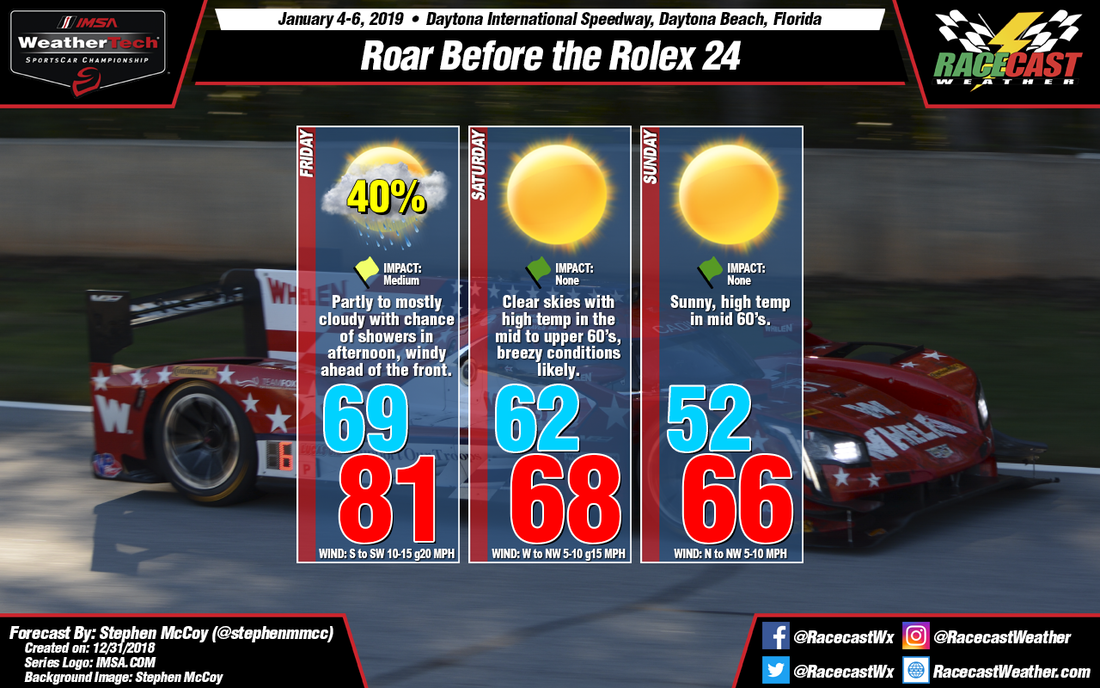
The 2019 IMSA season kicks off later this week with the Roar Before the Rolex 24 at Daytona International Speedway. Conditions look to start with some clouds and rain, but will end with lots of sunshine and temperatures in the mid to upper 60's.

An upper level shortwave trough is expected to develop over the southwestern US Tuesday into Wednesday as it closes off and splits from an upper level longwave trough. On Thursday, a surface low pressure system will form over the Gulf of Mexico, ahead of the trough and track northeastward through the rest of the week. A cold front will extend from the system as it approaches the Midwest Thursday night.

On Friday, winds in the low levels will be from the southwest, bringing moisture from the Gulf of Mexico over the area, resulting in partly to mostly cloudy conditions through the day. Surface winds will also be mainly from the southwest, with the strongest winds occurring before the frontal passage; winds gusts could exceed 20 mph. There is a chance for precipitation towards that late afternoon or evening on Friday as the front approaches, though the models are split on timing of the approach; the ECMWF shows the front passing in the afternoon, the GFS shows it passing in the evening. Regardless, the precipitation has the possibility of occurring during the later on-track sessions on Friday.

After the front passes through on Friday, conditions will begin to clear as winds in the low levels bring drier air into the region from the west and northwest, though upper level winds from the southwest could cause some light cloud cover in the upper levels. An area of high pressure will build in behind the front and move towards the east on Saturday and Sunday, resulting in surface winds starting from the north to northwest then shifting to the northeast. With winds from the same direction in the low levels and at the surface on Saturday, wind speeds should be slightly higher than Sunday with gusts over 15 mph possible. Surface winds will also bring in cooler air to the region, with high temperatures on Saturday and Sunday reaching the mid to upper 60's.
Comments

Long term weather outlook for Florida for January through March 2019

12/26/2018

Comments

 
By Doug Schneider

The 2019 racing season is almost upon us, and we're excited to bring you another year of weather forecasts! You can check out the full schedule of race forecasts that we have planned for the year in the 2019 Schedule link at the top of the page. There may be some additional races to be added later, depending on whether we can find sponsorship (and if you're interested in sponsoring our forecasts, click on the Contact link at the top of the page). 

During January, February, and March, the season openers for all the major North American racing series take place in Florida. Around this time each year, I take a look at the long term outlook for Florida as forecast by the Climate Prediction Center. These guys are the experts at long term forecasting on time scales from a week to several months, so the graphics you see below are taken directly from them. If you'd like to learn more about what goes into making a long term forecast, see this post I wrote a few years ago.

Water temperature at the ocean surface is a big factor in predicting the long term weather patterns. Perhaps the most significant and well known ocean temperature anomaly is the El Niño-Southern Oscillation (ENSO) cycle (for more info about El Niño, click here). It affects the location of the jet stream across the Pacific Ocean, which in turn affects the track of low pressure systems across the United States. The change in the typical tracks of storms can cause increased precipitation across California and the southern U.S. While long term forecasters cannot say exactly how much rain will fall or how warm/cold temperatures will be, knowing if there will be an El Niño can help forecasters determine whether precipitation and temperature is likely to be above or below normal over a period of several months in a certain area. 

The CPC is expecting a weak El Niño through the rest of the winter and into the spring. When there is an El Niño, the southeastern United States tends to have a higher likelihood of above normal precipitation. The image below shows that Daytona Beach is located in the area that has a 50% chance of seeing above normal precipitation during January, February, and March.
Picture
The three-month temperature forecast below shows Daytona Beach in an area where there are equal chances of above or below normal temperatures. This means that the the predicted atmospheric pattern does not give a clear signal of whether temperatures or precipitation will be above or below normal. However, it is interesting to note that the southern half of Florida (including Sebring) has a low chance (about a 36% chance) of above normal temperatures. 
Picture
Another way to visualize these outlooks is by using a pie chart. There are three categories of what could happen with temperature and precipitation - above normal, below normal, or near normal. Splitting the pie equally would give about a 33.3% chance of each. Below is the three category outlook for Daytona Beach.  
Picture
The top pie chart tells us that there's a nearly equal chance of above, below, or near normal temperatures at Daytona in January, February, and March. Honestly, that doesn't tell us very much. However, the bottom pie chart of precipitation tells us that there is a 50% chance of above normal precipitation. The "above normal" slice of the pie is the largest slice, so it is the most likely outcome of the three. 

The normal amount of rainfall at Daytona Beach during January, February, and March is 10.05 inches. The outlook is telling us that the amount of rainfall during the same period in 2019 is likely to be more than that. It does not tell us how much more, or when the rain is going to occur. It is possible that every day of racing in Florida could be dry, and yet this outlook would still be accurate. 

That's the extent of what meteorologists can tell about the weather this far out in advance. You will probably see forecasts out there that show the exact temperature and rain chance for a specific day weeks in advance, but don't take those forecasts too seriously. Those type of forecasts are going beyond the limits of what science can tell us with reasonable confidence. 
Comments

2018 Racing and Weather Photo Gallery

12/11/2018

Comments

 
By Doug Schneider

It's time again for our annual Racing and Weather photo galley, a collection of photos through 2018 that combine our two favorite things at Racecast Weather. It's always a pleasure for me to create this collection of eye candy for you. Click on a photo to enlarge.

​You can see our previous Racing and Weather galleries here, here, and here.

I'd like to recognize and thank a couple of photographers who have been especially helpful to us through the year by providing their outstanding work for use in our forecast graphics on a regular basis - Joseph Bierschbach (Red Case Photography) and Adam Prescott (Prescott Motorsport). You'll see some of their photos below, and be sure to visit their websites to see more of their work. 
David Baltazar, VIR
Intercontinental GT Challenge, Bathurst
Ginetta
Joseph Bierschbach
Joseph Bierschbach, COTA
Kevin Ehrlich, Bathurst
Kevin Ehrlich, Nurburgring
BMW Motorsport, Nurburgring
Toby Whealdon, Martinsville Speedway
Automotiveblogz, Pikes Peak Hill Climb
Drew Philips, Pikes Peak Hill Climb
Porsche Motorsport, Laguna Seca
Adam Prescott, Bahrain
Stephen McCoy, VIR
Wright Motorsport, Daytona
Wayne Taylor Racing, Sebring
Joseph Bierschbach, COTA
Brian Cleary, Daytona
Matt Boyce/Prescott Motorsport, Mid-Ohio
Comments

    Social Feeds


    Instagram


    Authors

    Doug Schneider
    Scott Martin
    Stephen McCoy

    Harris Cooley 


    Partners

    Picture
    Picture
    Picture
    Picture
    Picture

    Categories

    All
    F1
    IGTC
    IMSA
    Indycar
    Le Mans
    MRTI
    NASA
    Outlooks
    Photos
    PWC
    Racecasts
    SCCA
    SRO
    Trans Am
    TUSC
    Verification
    Weather Education
    WEC


    Archives

    March 2023
    February 2023
    January 2023
    December 2022
    November 2022
    October 2022
    September 2022
    August 2022
    July 2022
    June 2022
    May 2022
    April 2022
    March 2022
    February 2022
    January 2022
    December 2021
    November 2021
    October 2021
    September 2021
    August 2021
    July 2021
    June 2021
    May 2021
    April 2021
    March 2021
    January 2021
    December 2020
    November 2020
    October 2020
    September 2020
    August 2020
    July 2020
    June 2020
    March 2020
    January 2020
    December 2019
    November 2019
    October 2019
    September 2019
    August 2019
    July 2019
    June 2019
    May 2019
    April 2019
    March 2019
    February 2019
    January 2019
    December 2018
    November 2018
    October 2018
    September 2018
    August 2018
    July 2018
    June 2018
    May 2018
    April 2018
    March 2018
    February 2018
    January 2018
    December 2017
    November 2017
    October 2017
    September 2017
    August 2017
    July 2017
    June 2017
    May 2017
    April 2017
    March 2017
    February 2017
    January 2017
    December 2016
    November 2016
    October 2016
    September 2016
    August 2016
    July 2016
    June 2016
    May 2016
    April 2016
    March 2016
    February 2016
    January 2016
    December 2015
    November 2015
    October 2015
    September 2015
    August 2015
    July 2015
    June 2015
    May 2015
    April 2015
    March 2015
    February 2015
    January 2015
    December 2014
    November 2014
    October 2014
    September 2014


Powered by Create your own unique website with customizable templates.