Racecast Weather - Your Source for Race Weather Information
  • Home
  • Racecasts
  • 2023 Schedule
  • Services
  • Contact
  • Bios
  • Links

Forecast update for the United States Grand Prix

10/21/2021

Comments

 
By Harris Cooley
Picture
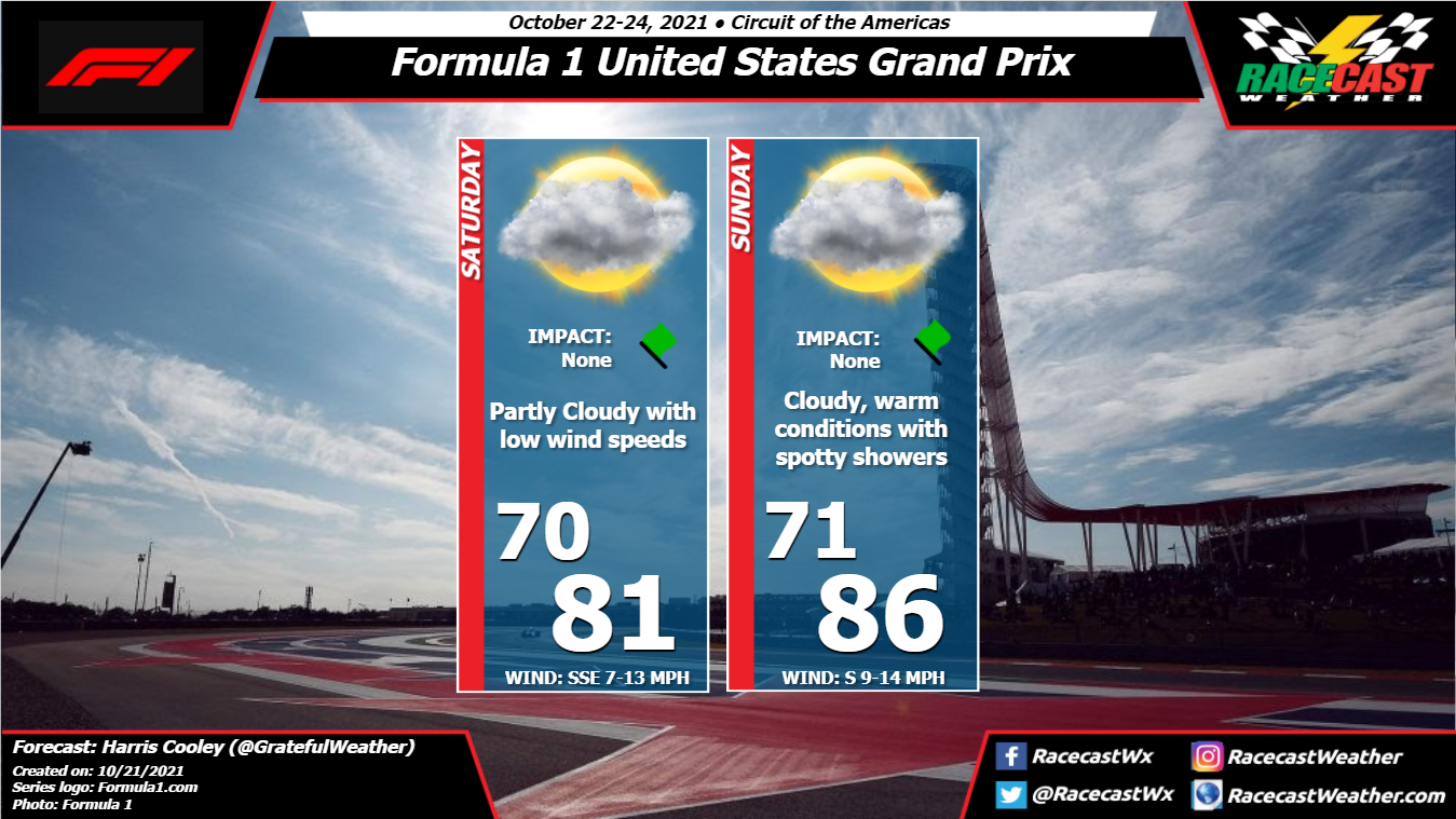
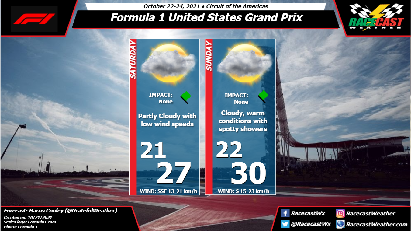
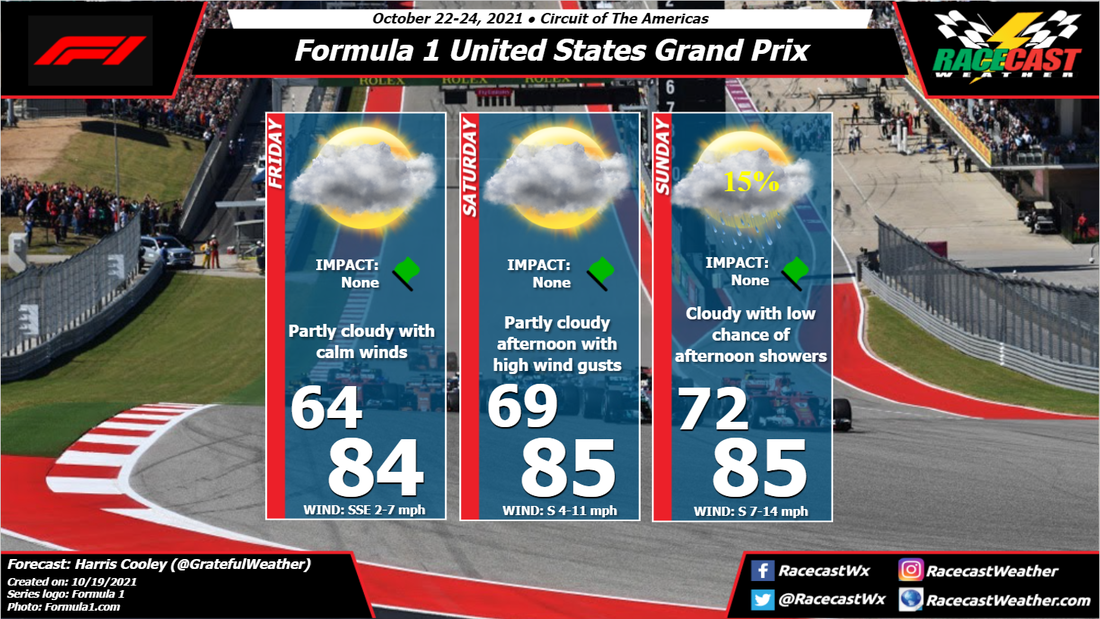
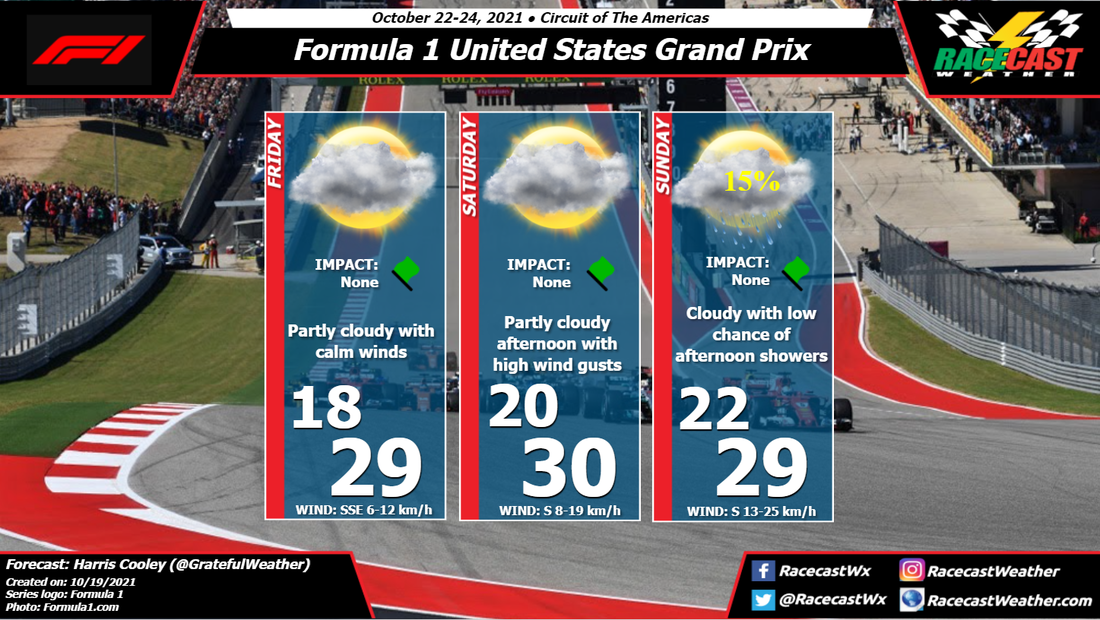
​The forecast remains consistent as of now with light to moderate southerly winds over the area for the whole weekend. This will keep a high moisture content over the area as well which could lead to some spotty showers around the track. Rain chances are low as a Low pressure system in Kansas will be deepening and keeping the storms north of the area. Warm and muggy weather will be expected for race day Sunday; typical Fall weather for Southern Texas. I will continue to track the likelihood of these storms over the track and keep you all updated. A metric graphic is attached below...
Picture
Comments

Initial forecast for the United States Grand Prix

10/19/2021

Comments

 
by Harris Cooley
Picture
As the circuit comes to the Lone Star State, some good weather will be present to greet the teams as well. Generally mild temperatures for this region are expected with low southerly winds and low chances of rain. Humidity will increase as the weekend goes on with the southerly winds, so we could see some spotty showers for the race Sunday. Chances are low as of now, but the lower pressures to the north of the area could expedite this process. I will continue to monitor this and keep you all updated. A metric graphic is displayed below...
Picture
Comments

Indianapolis 8 Hour: Wednesday Evening Update

10/13/2021

Comments

 
by Scott Martin
Picture
A surface low will be moving directly over the Indianapolis area on Friday that will bring showers and thunderstorms to the area throughout the day, with much of the activity occurring during the afternoon to early evening hours. Chances will be likely through the morning, but more scattered in nature. While it will not be a complete washout, some showers may be heavy at times. Rainfall amounts up to 1 inch are possible. Skies will be mainly cloudy when it's not raining. Temperatures will start off in the mid 60s around 7 am and warm into the lower 70s for the daytime high. Winds will be out of the southeast to southwest at 5-10 mph. Chance of rain is 60% during the morning and increasing to 90% by midday. Rain chances will stay elevated throughout the remainder of the day.

Saturday will be a much brighter, drier, and cooler day at the Brickyard as the system has moved well off to the east of the state. However, it will be breezy at times with winds averaging 5-15 mph out of the northwest with gusts potentially reaching as high as 25 mph. Skies will be mostly sunny, with temperatures starting off in the upper 40s around 7 am and climbing into the upper 50s for the daytime high.

While Sunday will start off rather cool, those temperatures will climb nicely underneath near-maximum sunshine. Winds will be averaging 5-10 mph out of the west throughout the morning, but a few gusts may reach as high as 20 mph during the afternoon hours. The 7 am temperature will be in the mid 40s with the daytime high reaching the lower 60s.
Comments

First Look at the Indianapolis 8 Hour Forecast

10/11/2021

Comments

 
by Scott Martin
Picture
A cold front will be working through the area on Friday that will bring a moderate chance of showers during the morning hours, and with the heating of the day, more showers and a few thunderstorms are expected to develop. Unfortunately, those higher rain chances look to come during the Downtown Speedway Parade. Skies will be mostly cloudy to overcast where there is no rain. Temperatures will start off in the lower 60s at the start of the day and will warm to just shy of 70 degrees for the daytime high. Winds will be out of the southeast to southwest at 5-10 mph. Chance of rain increases from 40% to 60%.

The cold front with the associated surface low will be slightly just to the east of Indiana on Saturday morning that will keep clouds and a small chance of a passing shower in the forecast during the morning hours. Once we get into the afternoon, skies will become mostly clear as clouds will be diminishing and rain chances dissipate. However, winds will be breezy out of the northwest, averaging 5-15 mph with gusts up to 25 mph at times. Temperatures will be cool throughout the day, starting off in the mid-50s and only rising into the upper 50s for the high. Chance of rain is around 30% to start, with chances decreasing throughout the morning.

Sunday will be a much brighter day at IMS as skies will be mainly sunny, but temperatures will remain on the cool side. A little breeze will make those temperatures feel even cooler at times as winds will be averaging 5-10 mph out of the west with the potential for gusts up to 20 mph. Temperatures will start off in the upper 40s when the gates open and will only climb into the lower 60s for the daytime high.
Comments

Saturday forecast update for the Turkish Grand Prix

10/9/2021

Comments

 
By Harris Cooley
Picture
​The forecast has remained consistent throughout the week with moderate to gusty northeasterly winds and overcast skies. The pressure gradient is tightened over the region with moisture blowing in off of the Black Sea. This will keep overcast skies in the area for most of the race day with a slight chance for showers in the morning. This will be keeping the teams on their toes as the showers will be scattered and unpredictable. It will be imperative for them to watch the radar and strategize around the track conditions. These conditions will make for an exciting race! A metric graphic is displayed below...
Picture
Comments

Friday forecast update for the Michelin GT Challenge at VIR

10/7/2021

Comments

 
By Doug Schneider
Picture
I'm feeling more optimistic about the weather conditions at VIR this weekend. While showers are likely on Saturday, the bulk of the rainfall is expected Friday night, with low impacts on the racing.

The chance of rain continues to drop for today. I expect a mix of sun and clouds through the day, with the possibility of a shower late in the day. A thunderstorm can't be ruled out, but the chance of lightning appears low. The WeatherTech qualifying session could be affected. Rain will be increasing Friday evening and continue overnight, which won't be great for campers but at least i won't affect any racing. Rain amounts through Friday night could be between a half inch and one inch.

Showers are likely to continue into early Saturday morning. I expect shower coverage to decrease during the late morning to early afternoon hours. It is possible that some showers in the area during the WeatherTech race, but the chance will be decreasing, from 70% in the morning to maybe 30-40% in the afternoon. Around a tenth to a quarter inch of rain is possible on Saturday. 

Sunday continues to look dry. With a mix of sun and clouds, highs will reach the mid 70s. Should be a very nice day for the Michelin Pilot Challenge race. 
Comments

First forecast for the Turkish Grand Prix

10/6/2021

Comments

 
By Harris Cooley
Picture
​The forecast looks quite consistent for this weekend beginning with gusty northeasterly winds for Friday. This is due to a tightened pressure gradient over the area, though this is supposed to relax by Saturday and Sunday bringing in calmer wind speeds. Though, this relaxing of the gradient will likely induce instability especially being so close to the sea, so we could very well see some light showers and overcast skies for the mornings. The afternoons should be a bit clearer, but there is still a definite chance of showers.

We saw how intermittent showers can affect a team/driver and their strategies... (Poor Lando) so it will be imperative to keep an eye on the radar. The conditions should not be as poor as they got at the end of the Russian GP, but any moisture is enough to cause some slipping around. I will continue to monitor this and keep you all updated with changing conditions. A metric graphic is displayed below...
Picture
Comments

Wednesday forecast update for the Michelin GT Challenge at VIR

10/6/2021

Comments

 
By Doug Schneider
Picture
While the forecast graphic hasn't changed much from my initial forecast, the timing and amount of rain is coming into better focus today. There are likely to be showers in the area of VIR starting Friday afternoon, and continuing through Saturday. However, this does not look like a wash-out, and I expect that the overall impacts will be low. There could be some practice sessions that are cut short by rain, but I don't think that the rain will be heavy enough to cause cancellations.

An upper level low pressure trough will be near the Appalachian Mountains on Friday, which will create a southeast flow of moisture off the Atlantic into the Piedmont of NC/VA. This system, along with some partial sunshine providing instability, will generate numerous showers and a few thunderstorms in the afternoon. The rain chances will be highest late in the afternoon as the day's activities are winding down. 

The good news in this forecast is that I expect the heaviest rain to fall on Friday night. It won't be great for campers, but at least it won't affect any racing action.

The upper trough will move east of VIR on Saturday, but there will still be some showers in the area as moisture remains high. I think these showers will mainly be light, and the risk of thunderstorms appears very low. Showers will be possible at any time of the day, but I think they will be most numerous in the morning, with lower chances in the afternoon. 

Rain amounts for Friday through Saturday are expected to be in the range of a half to one inch, but again, I expect most of that to accumulate on Friday night.

​Drier air is likely to build in on Sunday. I should mention that a couple models are showing some light showers lingering into Sunday, but other models keep Sunday dry and partly sunny. I'm leaning toward the more optimistic forecast being correct. 
Comments
<<Previous

    Social Feeds


    Instagram


    Authors

    Doug Schneider
    Scott Martin
    Stephen McCoy

    Harris Cooley 


    Partners

    Picture
    Picture
    Picture
    Picture
    Picture

    Categories

    All
    F1
    IGTC
    IMSA
    Indycar
    Le Mans
    MRTI
    NASA
    Outlooks
    Photos
    PWC
    Racecasts
    SCCA
    SRO
    Trans Am
    TUSC
    Verification
    Weather Education
    WEC


    Archives

    March 2023
    February 2023
    January 2023
    December 2022
    November 2022
    October 2022
    September 2022
    August 2022
    July 2022
    June 2022
    May 2022
    April 2022
    March 2022
    February 2022
    January 2022
    December 2021
    November 2021
    October 2021
    September 2021
    August 2021
    July 2021
    June 2021
    May 2021
    April 2021
    March 2021
    January 2021
    December 2020
    November 2020
    October 2020
    September 2020
    August 2020
    July 2020
    June 2020
    March 2020
    January 2020
    December 2019
    November 2019
    October 2019
    September 2019
    August 2019
    July 2019
    June 2019
    May 2019
    April 2019
    March 2019
    February 2019
    January 2019
    December 2018
    November 2018
    October 2018
    September 2018
    August 2018
    July 2018
    June 2018
    May 2018
    April 2018
    March 2018
    February 2018
    January 2018
    December 2017
    November 2017
    October 2017
    September 2017
    August 2017
    July 2017
    June 2017
    May 2017
    April 2017
    March 2017
    February 2017
    January 2017
    December 2016
    November 2016
    October 2016
    September 2016
    August 2016
    July 2016
    June 2016
    May 2016
    April 2016
    March 2016
    February 2016
    January 2016
    December 2015
    November 2015
    October 2015
    September 2015
    August 2015
    July 2015
    June 2015
    May 2015
    April 2015
    March 2015
    February 2015
    January 2015
    December 2014
    November 2014
    October 2014
    September 2014


Powered by Create your own unique website with customizable templates.