Racecast Weather - Your Source for Race Weather Information
  • Home
  • Racecasts
  • 2023 Schedule
  • Services
  • Contact
  • Bios
  • Links

Rain Looking To Be A Possible Player at Road America

7/31/2020

Comments

 
Picture
By Scott Martin

The activities taking place at and on the track on Saturday will stay dry as we'll have plenty of sunshine bathing the straights and twisty turns of Road America. Temperatures will start off around 62 degrees at 8:00 am underneath mainly sunny skies. There will be a few clouds to help shade you from the sun for a few minutes at a time once we get to the afternoon, but you will still need the shades, the hats, and the sunscreen. Afternoon highs look to top out at a very comfortable 78 degrees. Winds will be shifty throughout the day out of the north with some fluctuations out of the east and northeast at 5-10 MPH. Chance of any measurable rain is at 0%.

An impulse will be moving across Wisconsin throughout the day on Sunday that will bring a little lift and moisture to the area, especially during the afternoon hours. If any rain occurs, it doesn't look like it will be heavy and shouldn't cause a red flag. So, there is a 50/50 chance you may see the best racers in the world struggling for grip on a wet track. Temperatures start off around 69 degrees at 8:00 am and will warm up to around 76 degrees for the daytime high. Skies will start off partly cloudy, but more clouds will build throughout the morning and will be mostly cloudy by afternoon. Rain looks to become possible right around 12:00 pm and will be possible the afternoon and into the early evening. Winds will be out of the north to northeast at 5-10 MPH. Once again, rain chances will be around 50% for now.
Comments

Thursday forecast update for the Cadillac Grand Prix of Sebring

7/16/2020

Comments

 
By Doug Schneider
Picture
Not much has changed in the forecast for Friday and Saturday at Sebring since my initial forecast on Tuesday. A tropical upper level low pressure system is expected to move slowly west across southern Florida, which will enhance the chance of afternoon showers and thunderstorms both day.

The main impact of any showers and thunderstorms will be lightning and very heavy rainfall. Because of the potential for heavy rain to cause ponding of water on the track, and relatively high confidence of storms occurring, I have rated the Impact as Moderate. Some sessions or races may need to be stopped for a period. The good news is that any showers or storms should be short-lived, lasting maybe 20-40 minutes on average. For both Friday and Saturday, the most likely time period for showers and storms will be between 2 pm and 6 pm. 
Comments

Forecast update for IOWA INDYCAR 250s

7/16/2020

Comments

 
By: Stephen McCoy
Picture
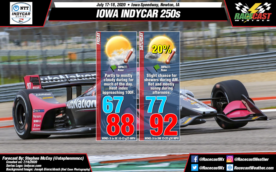
Precipitation chances for this weekend have shifted more towards overnight Friday into Saturday morning, posing little to no threat to on track sessions. Hot conditions are still expected to be present, with daily high temperatures in the upper 80's to low 90's anticipated. Dew point temperatures in the mid 70's will result in heat index values or "feels like" temperatures around 100 degrees. Though air temperatures may cool a bit in time for the races, dew point temperatures are expected to increase into the evening, causing heat index values to remain mostly consistent through the latter half of each day. Strong southerly winds in the low levels of the atmosphere will increase wind speeds at the surface, resulting in breezy conditions for Saturday afternoon.
Comments

Initial forecast for IOWA INDYCAR 250s

7/14/2020

Comments

 
By: Stephen McCoy
Picture
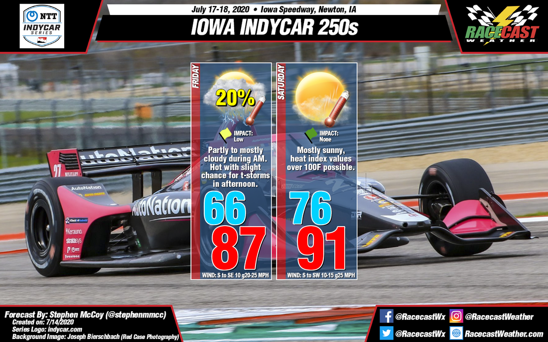
For Friday, a high pressure upper level ridge will be stretched through much of the southern US, with its edge approaching the Midwest; an accompanying surface high pressure system will be present underneath the ridge. A surface low pressure system will also be present to the west/northwest of the region in the northern plains. The combination of the cyclonic rotation around the low and the anti-cyclonic rotation around the high will result in surface winds over central Iowa from the south/southeast. The winds will help transport high levels of moisture to the region overnight Thursday into Friday morning. With similar air and dew point temperatures in the morning under a temperature inversion, fog may be possible near sunrise. Both air and dew point temperatures will increase through the day, with air temperatures reaching the upper 80's F and dew point temperatures reaching the mid 70's F. As a result of the warmer dew point temperatures, heat index values or "feels like" temperatures are expected to reach the upper 90's F. Race-time temperatures will be closer to the low 80's, though with consistent dew point temperatures, heat index values will still be in the low to mid 90's; temperatures will decrease throughout the evening. Partly to mostly cloudy skies will be present through much of the day.

A slight chance for isolated to scattered showers is also present for Friday afternoon due to the large influx of moisture over the region. Current forecast model output suggests thunderstorms in the region during the afternoon time period, though there is uncertainty on the specifics of when/where individual storms will be. Current impacts for track activities is low, however a passing storm would likely delay or possibly cancel qualifying.

During Saturday, the aforementioned surface low pressure system is expected to move eastward across the Great Lakes region, with a cold front trailing to the southwest of the center. Throughout Saturday, the front will remain to the northwest of Iowa, resulting in surface winds continuing from the south. Warmer temperatures are then expected for Saturday, with a low in the mid 70's and a high in the low 90's. Dew point temperatures in the mid to upper 70's will cause heat index values to approach triple digits in the afternoon, and could last into the evening, including the start of Saturday's race. Adding insult to injury, little cloud cover is anticipated during the day, meaning that health risks such as sunstroke, heat cramps, and heat exhaustion are a possibility.
Comments

First forecast for the Cadillac Grand Prix of Sebring

7/14/2020

Comments

 
By Doug Schneider
Picture
A wet weather pattern is expected to develop over Florida late this week, which could potentially have some impacts on the Cadillac Grand Prix events on Friday and Saturday.

There will be some dry air over Florida on Thursday, which will keep the chance of showers and thunderstorms low. Afternoon showers are pretty common this time of year at Sebring, so just a 20% chance is lower than normal. Still, if one of these showers moves over the track, it could produce brief heavy downpours. Sunshine in the morning hours will raise temperatures well into the 90s, with very humid conditions. The heat index could rise to the 100-105 range in the afternoon. 

An upper level tropical low pressure trough will be moving from east to west across the Atlantic and across Florida on Friday and Saturday. This system will bring deep moisture and instability to the area, making afternoon showers and thunderstorms likely both days. The main impact from any showers ans storms will be lightning and heavy downpours that could produce a very high amount of rain in a short period. With the high probability of rain and the potential for it to be heavy, I have the expected impact as Moderate, as ponding of water on the track could result in some delays. The increased cloud cover will help hold temperatures back to around 90 degrees.but that won't be much consolation with the high humidity.
Comments

Thursday forecast update for GT World Challenge at VIR

7/9/2020

Comments

 
By Doug Schneider
Picture
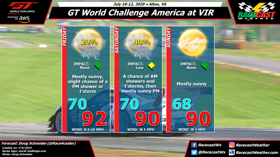
The main change to the forecast since Tuesday is a shift in the timing of the best chance of showers and thunderstorms on Saturday. Fortunately, this change is for the better, as the majority of rain is expected to pass through south-central Virginia on Friday night and early Saturday morning, with a low chance of impacts on the racing action. 

Some pop-up afternoon showers and thunderstorms will be possible on Friday, mainly near the higher terrain to the west of Danville. They will be moving east, but the chance of one of them reaching VIR before the end of the day's sessions is unlikely.

A passing trough and cold front are likely to bring showers and thunderstorms overnight and into early Saturday morning. There is a chance that some of the morning sessions could be impacted by these showers, possibly the GT qualifying from 8:30 to 9 am, and possibly the GT4 Sprint race at 9:25 am. Through the rest of the day, clouds will clear out and it will be mostly sunny, with high temperatures around 90 degrees. 

Drier air behind the departing trough will keep Sunday dry and sunny, with a high temperature around 90 again. 
Comments

First forecast for GT World Challenge at VIR

7/7/2020

Comments

 
By Doug Schneider
Picture
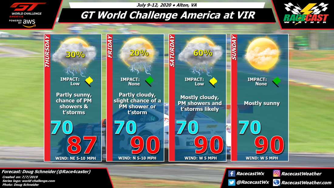
The season opener for GT World Challenge at VIR may be affected by some showers and thunderstorms, particularly on Saturday, but the vast majority of the racing action should be completed in dry conditions. 

A low pressure system is expected to be moving northeast across South Carolina and eastern North Carolina on Thursday. Even though it's just a couple days away, there are some big differences between the models in their placement of this low, and how much rain it brings to VIR. I'm going to be optimistic with my forecast, and only have a 30% chance of afternoon showers and thunderstorms. This is how most of the models are leaning, but the NAM shows much greater shower coverage. Hopefully it's an outlier. 

On Friday the low pressure system will be moving up the East Coast, and will no longer affect southern Virginia. With a lack of any significant high or low pressure systems in the area, I expect that Friday will be a typical summer day, with a few isolated showers or a thunderstorm possible in the afternoon, and a high around 90 degrees. 

Saturday appears to have the best chance of rain as an upper level trough and a surface cold front approach from the west. This system will provide lift and instability that will favor the development of showers and thunderstorms, mainly in the afternoon. There is a little uncertainty about the timing of the trough passage, and if it comes earlier there could be some morning showers as well. But the afternoon will be the more likely timing. 

Drier air aloft will build across the area behind this system, and which should result in a dry and mostly sunny day on Sunday. It will still be rather hot, with a high around 90.
Comments

1st Forecast for the REV Group GP at Road America

7/6/2020

Comments

 
Picture
By Scott Martin.

The NTT Indycar Series along with the USF2000 and IndyPro 2000 makes a trip to Road America for the REV Group Grand Prix weekend.

USF2000 & Indy Pro 2000 (Thursday & Friday)
An active pattern looks to bring a good chance of rain and thunderstorms mainly during the afternoon and early evening hours on Thursday for testing and practice sessions for both series. Temperatures will start off around 80 degrees and warm to around 89 degrees for the daytime high. Winds will be out of the southwest to south at 5-10 MPH. Rain chances will start off around 40% early but will max out at 70% by the early afternoon and persist through the end of the racing day.

Rain may hold off for most of the day on Friday until the late afternoon hours before the end of the racing day. I'm still going to include a very small chance of rain early but those odds will max out around 30% during the afternoon hours. Winds will be out of the west at 5-10 MPH. Temperatures will start of around 75 degrees and will warm up to around 85 degrees by the afternoon.

NTT Indycar Series (Saturday & Sunday)
Whether you would like to see the fastest racers in the world drive in the dry or in the wet, it looks like the dry-weather fans may win out this weekend. Saturday and Sunday will feature a great deal of sunshine early on, but convective clouds will slowly build during the late morning and early afternoon hours. There will be a very small chance of a passing shower or thunderstorms, but those will not be very likely. Saturday's temperatures will start off around 82 degrees for the first session and top out around 83 degrees during the afternoon. Sunday's temperatures will be around 76 degrees for qualifying and topping out around 80 degrees by the afternoon. Chance of rain on both days is barely at 20%.
Comments
<<Previous

    Social Feeds


    Instagram


    Authors

    Doug Schneider
    Scott Martin
    Stephen McCoy

    Harris Cooley 


    Partners

    Picture
    Picture
    Picture
    Picture
    Picture

    Categories

    All
    F1
    IGTC
    IMSA
    Indycar
    Le Mans
    MRTI
    NASA
    Outlooks
    Photos
    PWC
    Racecasts
    SCCA
    SRO
    Trans Am
    TUSC
    Verification
    Weather Education
    WEC


    Archives

    March 2023
    February 2023
    January 2023
    December 2022
    November 2022
    October 2022
    September 2022
    August 2022
    July 2022
    June 2022
    May 2022
    April 2022
    March 2022
    February 2022
    January 2022
    December 2021
    November 2021
    October 2021
    September 2021
    August 2021
    July 2021
    June 2021
    May 2021
    April 2021
    March 2021
    January 2021
    December 2020
    November 2020
    October 2020
    September 2020
    August 2020
    July 2020
    June 2020
    March 2020
    January 2020
    December 2019
    November 2019
    October 2019
    September 2019
    August 2019
    July 2019
    June 2019
    May 2019
    April 2019
    March 2019
    February 2019
    January 2019
    December 2018
    November 2018
    October 2018
    September 2018
    August 2018
    July 2018
    June 2018
    May 2018
    April 2018
    March 2018
    February 2018
    January 2018
    December 2017
    November 2017
    October 2017
    September 2017
    August 2017
    July 2017
    June 2017
    May 2017
    April 2017
    March 2017
    February 2017
    January 2017
    December 2016
    November 2016
    October 2016
    September 2016
    August 2016
    July 2016
    June 2016
    May 2016
    April 2016
    March 2016
    February 2016
    January 2016
    December 2015
    November 2015
    October 2015
    September 2015
    August 2015
    July 2015
    June 2015
    May 2015
    April 2015
    March 2015
    February 2015
    January 2015
    December 2014
    November 2014
    October 2014
    September 2014


Powered by Create your own unique website with customizable templates.