|
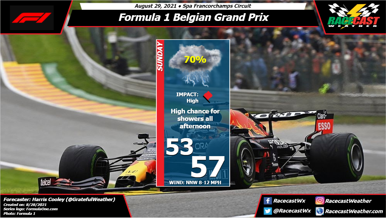
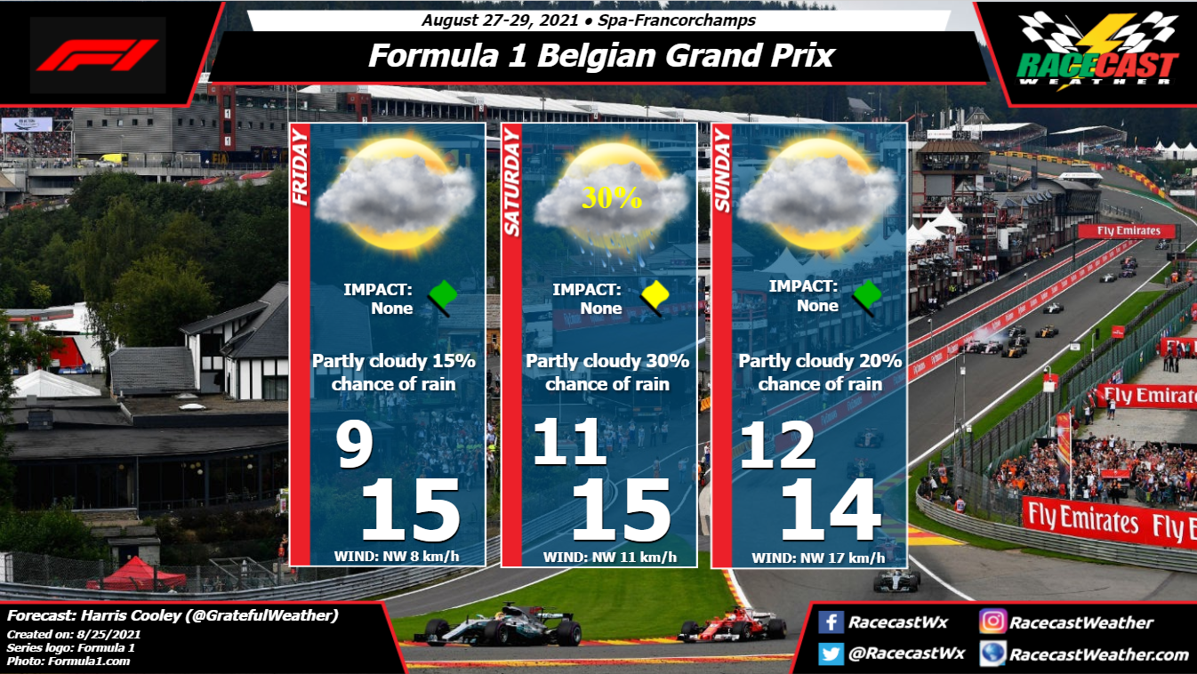
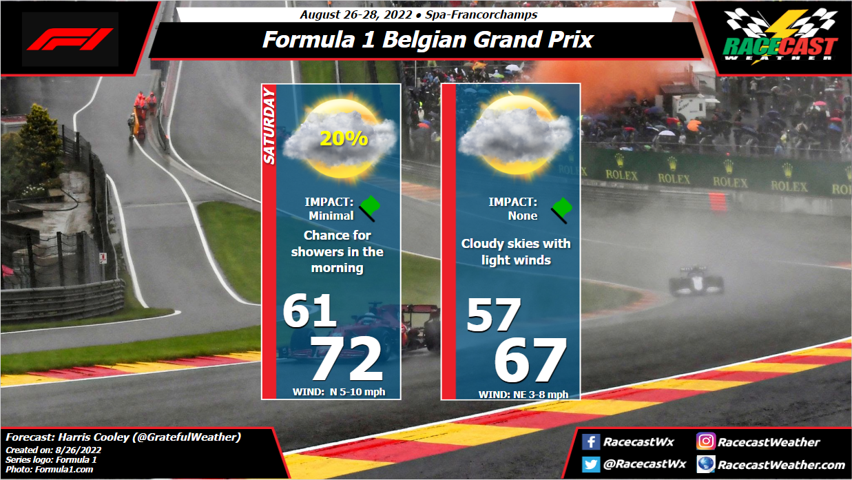
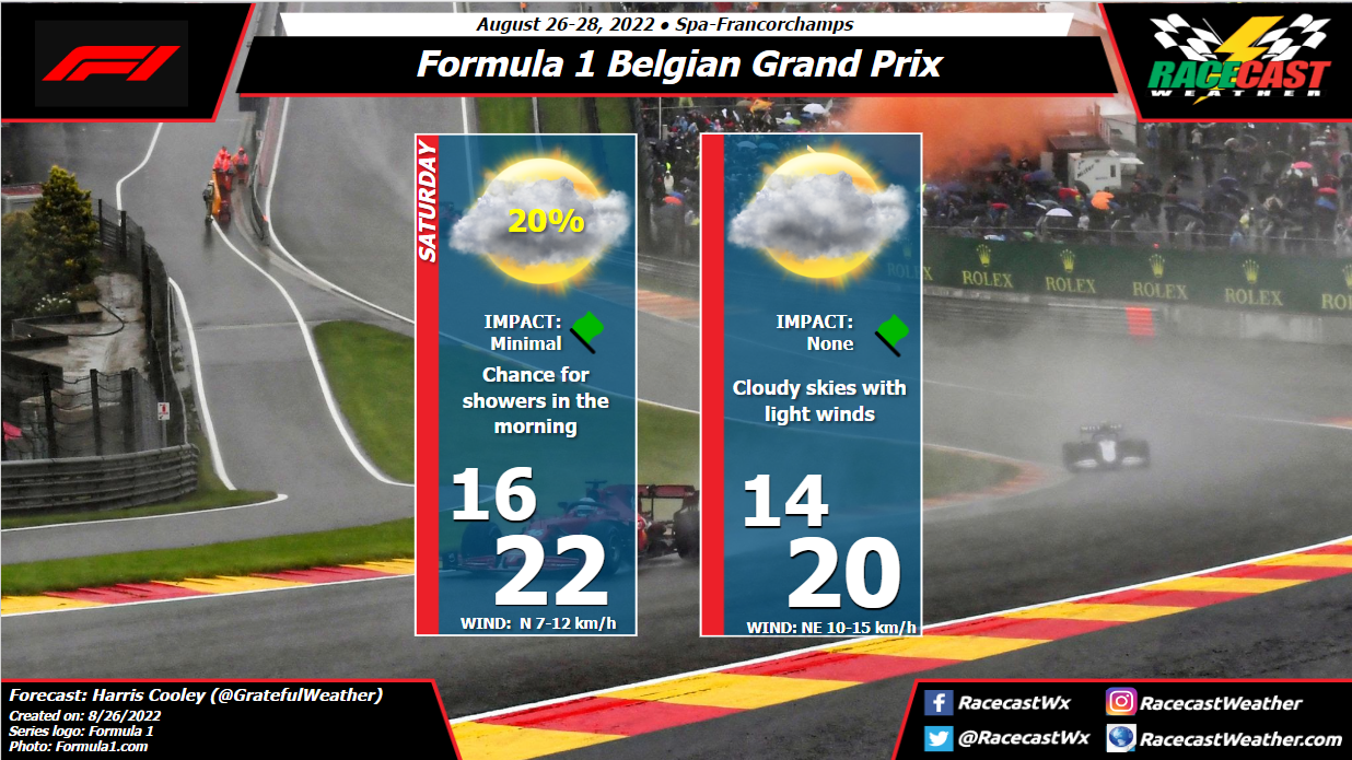
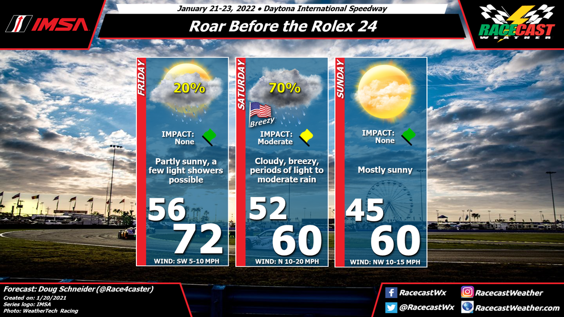
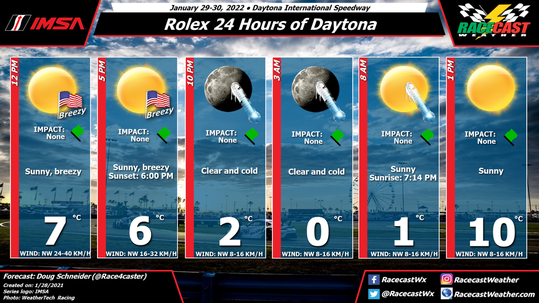
By: Harris Cooley The storms caused quite an issue out on the track today with very limited visibility. Storms are expected to be rolling through the area tomorrow as well with the northwesterly winds. It will be interesting to see how these drivers deal with the conditions as it does not appear to be letting up. Metric graphic below...
by Scott Martin It's very busy for me in the Southeast as we will have a very powerful hurricane making landfall on the Gulf Coast, so my main attention will be focused there. Here is a brief forecast update for Road America and the SRO World Challenge Weekend.
Plenty of sunshine and plenty of heat with only a very small chance of a passing shower, High will be around 89 degrees with heat index values approaching 98 degrees. Winds will be out of the southwest at 5-15 mph and the chance of rain is only 30%. Sunday will be a partly cloudy day and only a little cooler, but there will be a decent chance of a few showers and storms during the afternoon hours. I wanted to increase the rain chances to 50%, but decided to hold back because of the scattered nature. It will be breezy at times, with winds out of the southwest to west at 10-20 mph. Highs will be in the mid 80s. By: Harris Cooley The forecast remains quite consistent from the last one with cool temps and good chances of rain for this weekend. A large Low pressure system to the northeast of the area is bringing in moisture from the north that will keep overcast skies and occasional gusts of wind over the site. Storms are expected to be moving through the area throughout the whole weekend, so we are expecting a wet track out there as of now. It is hard to say where exactly these storms will be and how long they will last, but team's can expect moisture out on the track either way. I will keep watching this closely and update you all with developing information. As always, the metric graphic is below...
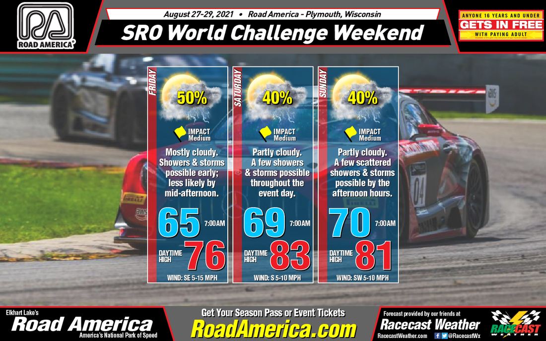
by Scott Martin After a very busy past two weeks for me covering severe weather, flooding, and the passage of Tropical Storm Fred through the southeastern US, I finally can post a forecast discussion for the races that I am covering this weekend. I apologize to the Indycar fans who stop by our site for the forecasts, as those were limited to Facebook and Twitter posts due to the amount of coverage I was taking part in with my day job. Here is what I have for you for this weekend's World Challenge action at Road America.
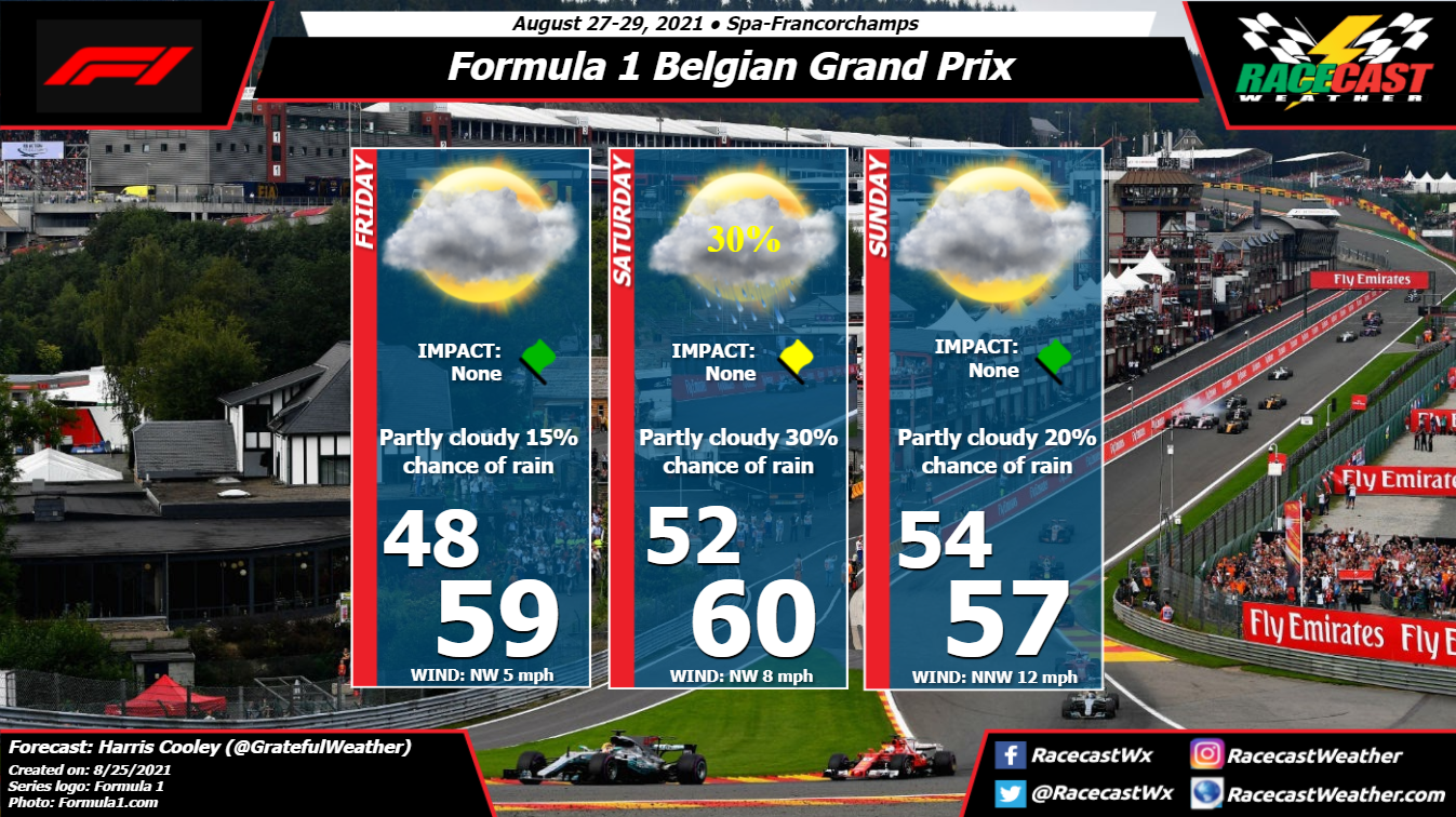
On Friday, a warm front will be working its way northward to the southern part of Wisconsin that will keep an already unstable atmosphere active as there will be plenty of heavy showers and storms that will already be moving through the northern half of Wisconsin. For the track, scattered to numerous showers and storms will be possible during the morning and into the start of the afternoon hours, but rain chances will drop to a small chance by the mid-afternoon hours. Skies will be mostly cloudy throughout the day, with the afternoon high maxing out in the mid-70s. Rain chances will be around 50% to start the day, but will eventually fall to around 30% by the mid-afternoon hours. Winds will be out of the southeast at 5-15 mph. The good news is the coverage in the scattered shower and thunderstorm activity will be less on Saturday, even though we'll be in-between a warm front to the north and a cold front to the west. The overall rain chance will be maxed out around 40% mainly during the morning hours, but becoming a little less likely during the afternoon to early evening hours. Skies will be partly cloudy, with afternoon highs topping out in the lower 80s. Winds will be out of the south at 5-10 mph. The cold front will get closer to the area on Sunday, and it will keep the overall shower and thunderstorm chances around 40%, mainly during the afternoon hours, but we can't rule out a passing shower before that. Skies will be partly cloudy and afternoon highs will max out in the lower 80s. Winds will be out of the southwest at 5-10 mph. By: Harris Cooley After the Summer break in the season, we kick off the rest of the season starting at the Spa in Belgium. As of now there is a slight chance of rain, mostly for Saturday, with cool temperatures and occasional gusts of wind throughout the weekend. Because of these conditions, grip around the track will be spotty especially if we see rain throughout the weekend. Northwesterly winds will be bringing moisture to the area, so cloud coverage will be likely throughout the weekend.
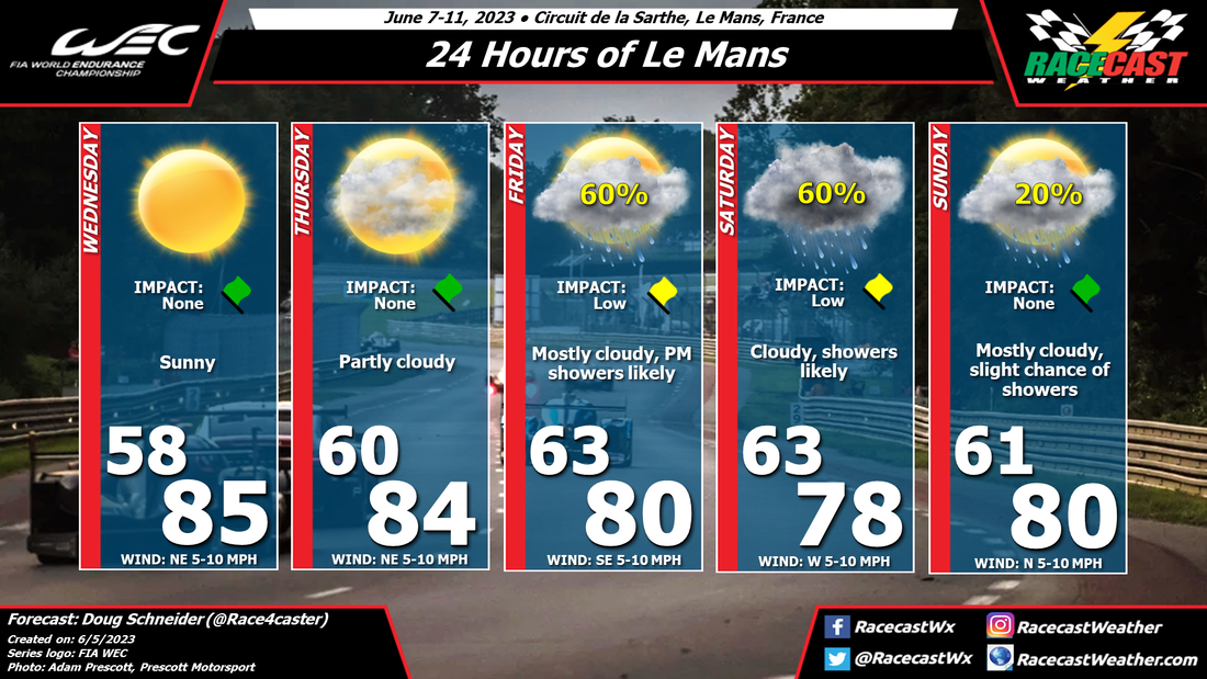
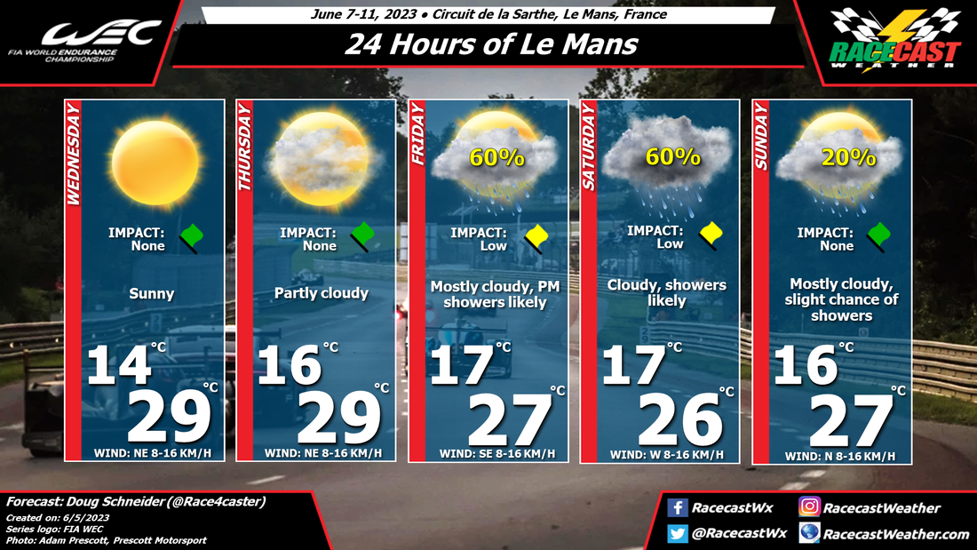
I will continue to watch the models and pinpoint when these storms are most likely to come to the area. A metric graphic is displayed below... By Doug Schneider Click images to enlarge The forecast for Le Mans has been really tough this year, as the models have been flip-flopping regarding the timing of a low pressure system that will cross northern France and England. The good news is that they seem to be coming into better agreement, and showing better consistency. The most likely time period for showers at the track appears to be from late afternoon on Saturday into the evening. There could still be some light showers or sprinkles that continue overnight and into Sunday morning, but those should be light. Bottom line, I think the biggest potential impacts from rain could be around the start of the race. Temperatures will be on the cool side due to the extensive cloud cover from this system and behind it on Saturday and Sunday.
by Doug Schneider Click images to enlarge The models have taken a pretty big shift over the past few days, and are now showing a good chance of rain during the race.
The days leading up to the race should have good weather for practice, qualifying, and support races. Temperatures will be comfortable for Wednesday through Friday, gradually climbing from the lower to mid 70s F to lower 80s F, under partly cloudy skies each day. There is agreement among the models that a low pressure system will track from the northern Atlantic to the English Channel over the weekend. This should bring a chance of rain to Le Mans starting late Saturday afternoon. The system will be slow-moving, so the chance of rain will continue Saturday night and Sunday. At this time, it is nearly impossible to pin down the timing more precisely than that. Timing should become more clear later in the week. Temperatures should be warm at the start of the race Saturday afternoon, then become cooler on Sunday behind a cold front. By Doug Schneider Click on forecast graphics to enlarge The weather for Le Mans looks great this year. A few showers are possible on Thursday, and while the race day is still a week away, it appears that the weather pattern will favor a dry race.
Temperatures are very hot right now across France as a large high pressure system is in control of the weather. But that will change in a few days as a cold front is expected to cross northern France on Monday, followed by cooler temperatures. Behind the front on Wednesday, expect mostly cloudy skies and highs in the mid 70s F, or mid 20s C. Models differ on the chance of rain for Thursday. Some show a completely dry day, while other show a disturbance in the mid and upper levels crossing northern France. I think there is enough of a chance of the later scenario that I needed to include a small chance of showers on Thursday. But the impact looks small if showers do occur, as it is a weak and fast-moving trough. A ridge of high pressure is expected to build over the western Atlantic on Friday, and continue to build east into Spain and France over the weekend. It will provide dry conditions and warming temperatures, with highs peaking on Sunday in the upper 80s F, or lower 30s C. I'll be away for a few days, so my next planned update will be on Tuesday. |
Social Feeds
Authors
Doug Schneider Partners
Categories
All
Archives
December 2023
|

