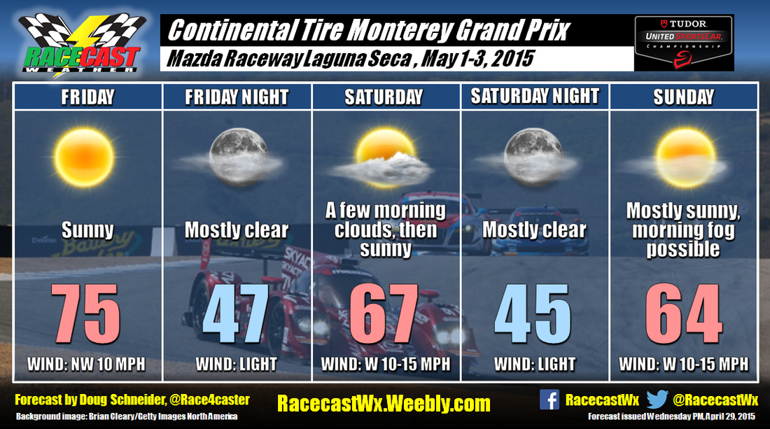
By Doug Schneider
If you are at a race track, and hazardous weather is approaching, do you know what action to take? If you are caught outside in a thunderstorm and no adequate shelter is readily available, what would you do?
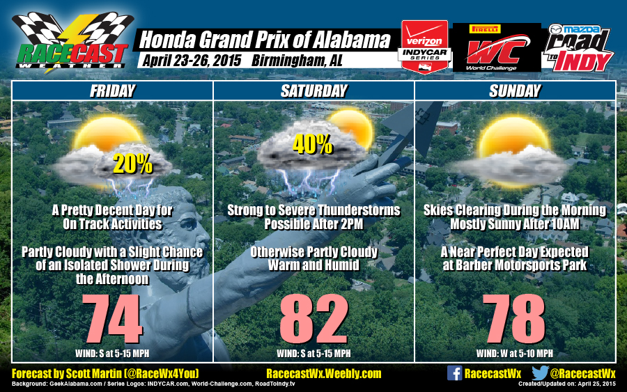
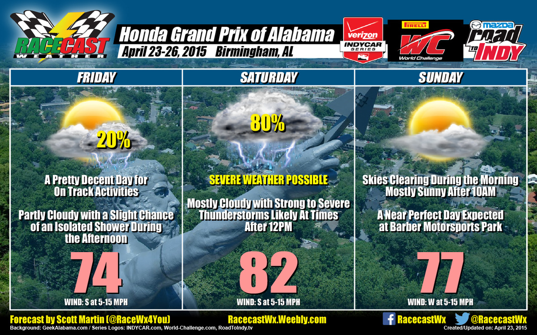
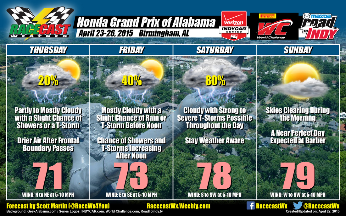
I've been thinking about these questions for the past few days since attending the Honda Indy Grand Prix of Alabama at Barber Motorsports Park. On Saturday afternoon, thunderstorms were approaching the track, and the notice to seek shelter was announced and displayed on the screens around the track.
A couple weeks ago, I wrote a post to point out the inaccurate use of the term "severe" weather in IndyCar's notice for fans to seek shelter at NOLA Motorsports Park. At both NOLA and Barber, the approaching storms were in no way "severe" by the NWS definition - the hazard with the thunderstorms in both events was lightning, and lightning does not make a thunderstorm severe. The notifications to seek shelter in both events were headlined with "severe weather advisory", which is misleading, and in my opinion, irresponsible. But I did notice an improvement with the statement below the headline at the Barber event (left) compared the the one used at NOLA (right):
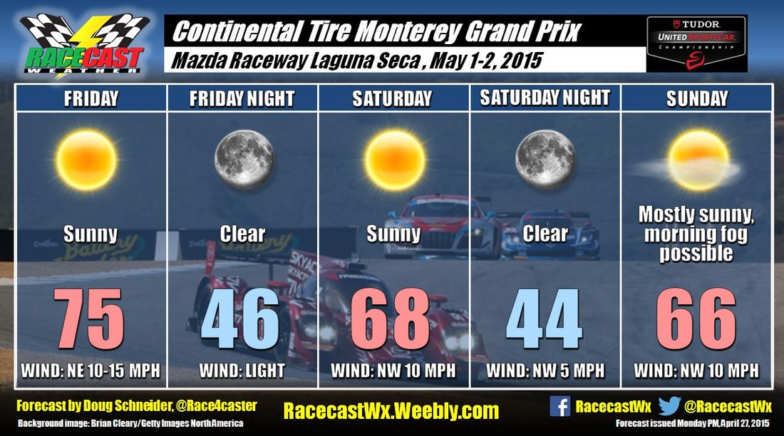
If you are at a race track, and hazardous weather is approaching, do you know what action to take? If you are caught outside in a thunderstorm and no adequate shelter is readily available, what would you do?
I've been thinking about these questions for the past few days since attending the Honda Indy Grand Prix of Alabama at Barber Motorsports Park. On Saturday afternoon, thunderstorms were approaching the track, and the notice to seek shelter was announced and displayed on the screens around the track.
A couple weeks ago, I wrote a post to point out the inaccurate use of the term "severe" weather in IndyCar's notice for fans to seek shelter at NOLA Motorsports Park. At both NOLA and Barber, the approaching storms were in no way "severe" by the NWS definition - the hazard with the thunderstorms in both events was lightning, and lightning does not make a thunderstorm severe. The notifications to seek shelter in both events were headlined with "severe weather advisory", which is misleading, and in my opinion, irresponsible. But I did notice an improvement with the statement below the headline at the Barber event (left) compared the the one used at NOLA (right):
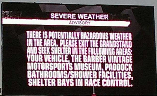 |  |
It may seem like a small difference, but the use of "potentially hazardous weather" was more appropriate to the situation than "severe weather". It's an improvement that is good to see, but the "severe weather" headline is still misleading. What happens with a real, genuine severe thunderstorm is approaching the track? Will it say, "Severe weather is approaching, and this time, we really mean it!"? By using exaggerated and inaccurate wording, the "severe" headline is conditioning people to not take real severe weather seriously. Please don't misunderstand what I'm saying - while lightning does not make a thunderstorm severe by definition, lightning is certainly very dangerous and should be taken seriously, and any calls to seek shelter from lightning should be heeded immediately. A more appropriate headline in both events would have been "Dangerous lightning advisory", or "Hazardous weather advisory".
At Barber, when the "severe weather advisory" was announced, I was in a hospitality tent in the Fan Zone area. We were told to head for the nearby tram stop to get to our car, as there was no sturdy shelter nearby. Of course, all the other fans in the Fan Zone headed to the same tram stop, and this was the result:
At Barber, when the "severe weather advisory" was announced, I was in a hospitality tent in the Fan Zone area. We were told to head for the nearby tram stop to get to our car, as there was no sturdy shelter nearby. Of course, all the other fans in the Fan Zone headed to the same tram stop, and this was the result:
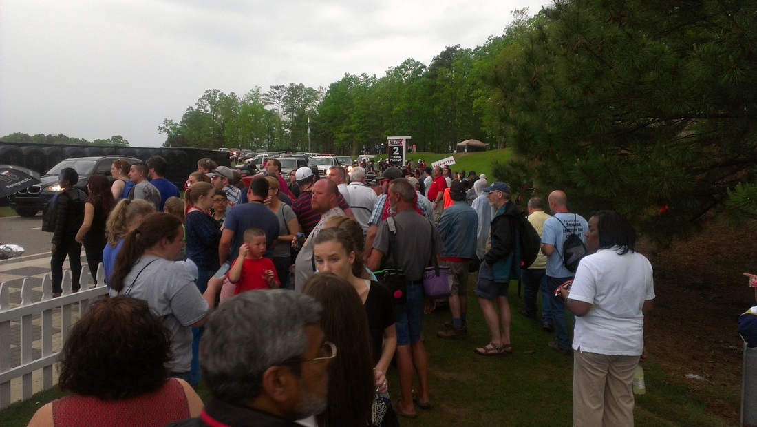
As you can see, the tram stop created a large crowd of people huddled closely together near an area of trees along a small ridge. There was also a pond nearby. This is a terrible place to be when lightning is approaching. There was a flash of lightning in the distance moments after I took this picture, but thankfully, it was still pretty far away. I did hear the thunder, and when thunder can be heard, lightning may be getting close enough to strike you. While being in a car is a safe place to be during lightning, getting to our car required at least 20 to 30 minutes of being exposed, whether we took the tram or walked. I counted four lightning strikes before we were able to reach our car, one of which was less than a mile away. The advice that was given in the announcement to seek shelter was inadequate for those of us who were in the Fan Zone on the backstretch, as all of the suggested shelter locations were at least a 15 minute walk away and the main parking lot was on the other side of the track. I felt like the call to evacuate put us into a more dangerous situation than if we had stayed where we were at the hospitality tent.
Barber is not alone in lacking adequate shelter for fans. In fact, it is probably better than most tracks since the museum can accommodate a large crowd. Of the other tracks I've been to, I can't think of a sturdy shelter that would provide protection for a large number of fans from lightning, much less from a severe thunderstorm or a tornado. It is amazing that there hasn't been a major weather-related disaster at a track with a large number of race fans being injured or killed. It is only a matter of time before that happens.
So what is the solution to this problem? How can this looming disaster be averted? Aside from race tracks spending a ton of money to build shelters big enough to contain hundreds or thousands of fans, the only solution is that fans stay aware of the weather while at the track, and know what actions to take when hazardous weather threatens. Taking the right action still won't guarantee safety, but it will significantly increase the odds of staying safe.
The best option when a thunderstorm is approaching is to find the nearest substantial building, or in an enclosed, metal-topped vehicle with the windows up. As soon as thunder is heard, lightning is seen, or the call to seek shelter is announced, you should immediately move to shelter. You may not have much time before the storm is on top of you. You should stay in the shelter for 30 minutes after the last sound of thunder is heard.
If lightning is occurring nearby and you don't have time to get to a building, you are NEVER safe. But here's what you should do (or avoid doing) to reduce your risk:
Herding people together into a group at a tram stop near trees and water is certainly not a good lightning safety practice. Neither is sending them to walk across an open field where their cars are parked.
Is there a better alternative? Honestly, I don't know what could have been done differently. Ultimately, it is not the track's responsibility to keep people safe - it is the responsibility of each individual to make the right choices and take appropriate action when threatening weather approaches. Hopefully the next time you're at the track when lightning is imminent and you find yourself without shelter, you will remember the proper actions to take listed above.
For more information about lightning and lightning safety tips, visit lightningsafety.noaa.gov.
Barber is not alone in lacking adequate shelter for fans. In fact, it is probably better than most tracks since the museum can accommodate a large crowd. Of the other tracks I've been to, I can't think of a sturdy shelter that would provide protection for a large number of fans from lightning, much less from a severe thunderstorm or a tornado. It is amazing that there hasn't been a major weather-related disaster at a track with a large number of race fans being injured or killed. It is only a matter of time before that happens.
So what is the solution to this problem? How can this looming disaster be averted? Aside from race tracks spending a ton of money to build shelters big enough to contain hundreds or thousands of fans, the only solution is that fans stay aware of the weather while at the track, and know what actions to take when hazardous weather threatens. Taking the right action still won't guarantee safety, but it will significantly increase the odds of staying safe.
The best option when a thunderstorm is approaching is to find the nearest substantial building, or in an enclosed, metal-topped vehicle with the windows up. As soon as thunder is heard, lightning is seen, or the call to seek shelter is announced, you should immediately move to shelter. You may not have much time before the storm is on top of you. You should stay in the shelter for 30 minutes after the last sound of thunder is heard.
If lightning is occurring nearby and you don't have time to get to a building, you are NEVER safe. But here's what you should do (or avoid doing) to reduce your risk:
- Immediately get off elevated areas such as hills, mountain ridges or peaks
- Avoid open fields
- Never lie flat on the ground
- Never shelter under an isolated tree
- Immediately get out and away from ponds, lakes and other bodies of water
- Stay away from objects that conduct electricity (barbed wire fences, power lines, windmills, etc.)
- If you are in a group, spread out to avoid the current traveling between group members.
- If you are camping in an open area, set up camp in a valley, ravine or other low area. Remember, a tent offers NO protection from lighting.
Herding people together into a group at a tram stop near trees and water is certainly not a good lightning safety practice. Neither is sending them to walk across an open field where their cars are parked.
Is there a better alternative? Honestly, I don't know what could have been done differently. Ultimately, it is not the track's responsibility to keep people safe - it is the responsibility of each individual to make the right choices and take appropriate action when threatening weather approaches. Hopefully the next time you're at the track when lightning is imminent and you find yourself without shelter, you will remember the proper actions to take listed above.
For more information about lightning and lightning safety tips, visit lightningsafety.noaa.gov.