Racecast Weather - Your Source for Race Weather Information
  • Racecasts
  • Radar
  • 2021 Schedule
  • Links
  • Bios
  • Contact

Wednesday forecast update: Petit Le Mans

9/30/2015

Comments

 
By Doug Schneider
Picture
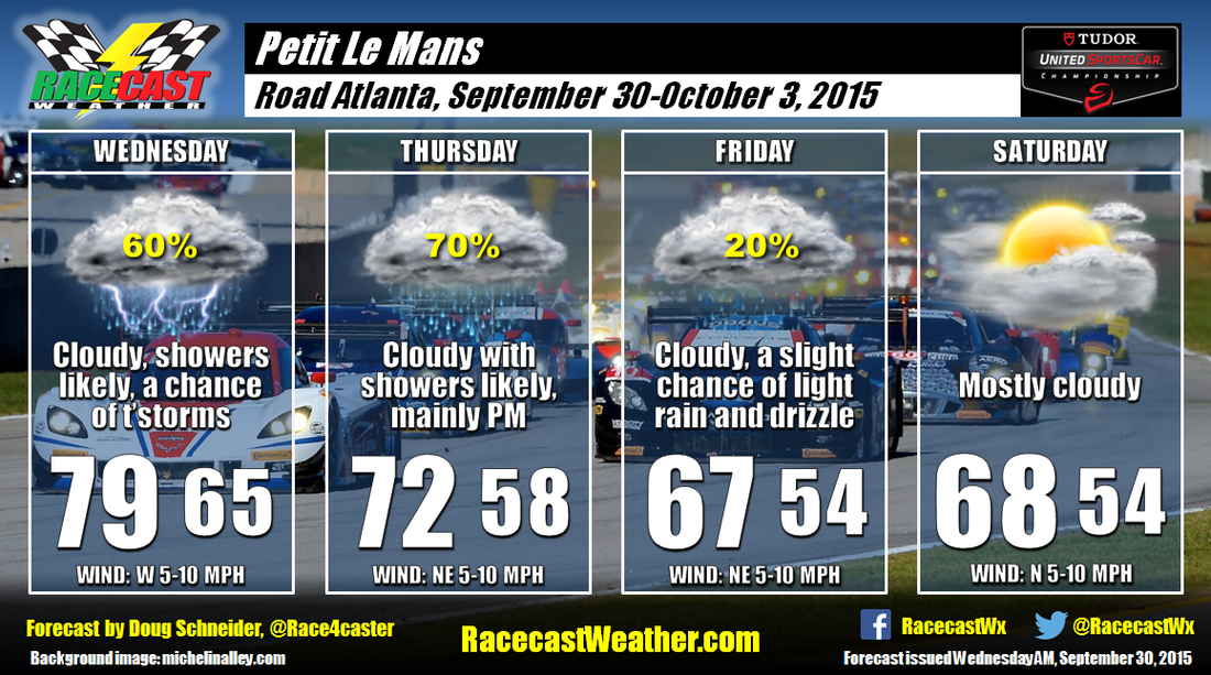
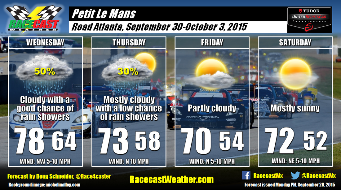
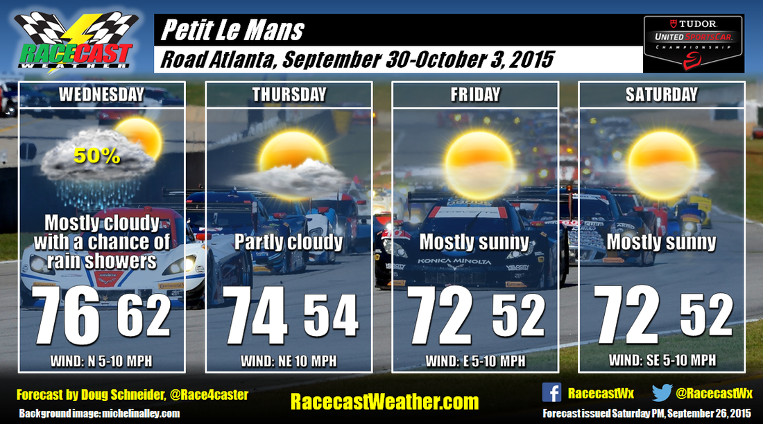
There Today's weather at Road Atlanta is expected to be cloudy and foggy through the morning, with showers likely to affect the track this afternoon. It is possible that there could be a thunderstorm as well. Around a quarter inch of rain is expected. Highs will be in the upper 70s. 

A cold front will be near the area tonight, and push south of the track on Thursday. The proximity of this front to the track and the presence of an upper level low pressure system will mean that showers are likely again on Thursday. Most of the rainfall is expected to come in the afternoon and evening. For Thursday, another quarter inch of rain will be possible. 

Friday continues to be the day that is most questionable as the weather pattern will be transitioning. The upper level low pressure system will be slow to exit the area, and there will still be quite a bit of low level moisture. This is not a pattern that tends to produce heavy rain. In fact, there may only be a trace of rain or around a hundredth of an inch of rain. This is why I only have a 20% chance of measurable rain. I want to emphasize that the majority of Friday is likely to be dry, and I don't expect that what little rain there is will have much impact. It will be cloudy and fairly cool all day, with high in the upper 60s.

Clouds will be around for most of the day on Saturday, but I do expect that there will be some sunshine to break through the clouds, mainly in the afternoon. The upper level low pressure system should take all the rain east of the area, across the Carolinas. I expect that the race will be dry from start to finish. I do have to mention that the GFS model continues to show a high chance of rain on Saturday. Other models show a low chance. In my experience, the GFS tends to produce too much rain in this type of weather pattern, so I'm leaning toward the drier models. I think there will be too much dry air moving in and not enough lift in the atmosphere to produce measurable rainfall. Temperatures will continue to be a little cool, with highs in the upper 60s, and temperatures by the end of the race around 60.

We'll have our radar link ready to go at the top of the website later today.
Comments

Racecast verification: Lone Star Le Mans and Trans Am at VIR

9/29/2015

Comments

 
By Doug Schneider

COTA and VIR are two really good tracks to verify forecasts because there is an airport with a reliable weather sensor within ten miles of both tracks. So here's a look back at how I did with my forecasts for Lone Star Le Mans and Trans Am at VIR.
Picture
Lone Star Le Mans was not a difficult forecast as I was confident that most of the event would stay dry, with the exception of Wednesday. Temperatures were clearly the main concern, with highs each day reaching into the lower to mid 90s. There was a shower that grazed the track on Wednesday, and 0.01 inches of rain was recorded at the airport that day, verifying my 20% rain chance. My forecast high temperatures were never off by more than two degrees. 
Picture
Trans Am had a very wet weekend at VIR. I'm pretty sure every session was affected by rain or at least a wet track. My initial forecast called for a chance of rain on Thursday, Friday, and Saturday, but I did not have it lasting into Sunday. My next forecast update corrected that, with rain chances rising to 70% Thursday night through Saturday, then up to 100% on my next update. This was the period when the greatest amount of rain fell. Light rain continued into Sunday, and a light mist or drizzle was over the track for the race start on Sunday afternoon. My forecast temperatures verified pretty well each day and night. What I didn't forecast well (and it doesn't show up in the chart) is rainfall amounts. In my posts, I had mentioned 0.5 to 1.5 inches with my 9/23 forecast, then 1 to 2 inches with my 9/24 forecast. Both of these forecasts were actually on the higher side of what the models were predicting. It turned out that 4.74 inches of rain was recorded through the event at the Danville airport!
Comments

Monday forecast update: Petit Le Mans

9/28/2015

Comments

 
By Doug Schneider
Picture
The main change to the forecast today has been for a slower low pressure system through midweek, which will extend the change of rain into Thursday. 

Wednesday will have a good chance of rain showers all day, but it will be the warmest day of the event, with highs in the upper 70s. On Thursday the cold front at the surface will have moved through, bringing cooler temperatures. However the upper level trough is slow to exit, and will be over Georgia through the day. This will result in some scattered showers around the track all day. The trough is expected to slowly move away, taking most of the deep moisture with it, so I don't expect that the showers will last into Friday at this time. If the models continue to show a slower system, I may need to add a chance of rain into Friday. 

Race day continues to look really nice as high pressure builds over the area. Mostly sunny skies and highs in the lower 70s can be expected. Temperatures by the end of the race will drop to around 60, so bring a jacket. 
Comments

Forecast for Petit Le Mans

9/26/2015

Comments

 
By Doug Schneider
Picture
I'm happy to report that (so far!) the weather looks great for Petit Le Mans next weekend at Road Atlanta.

A cold front and upper level trough of low pressure will be crossing the southeast on Wednesday. The bulk of the rain associated with this system will likely come on Tuesday and Tuesday night, but there is a chance of some showers lingering into Wednesday. The system will exit Wednesday night, and as high pressure builds in, cooler and drier air will be sliding into northeast Georgia from the northeast. This should make for comfortable daytime temperatures and low humidity Thursday through Saturday. Highs will be in the lower to 70s, and morning lows may be a little on the cool side, dropping into the lower to mid 50s each morning. 

The latest run of the GFS model develops a low pressure system over the Plains and moves it into Tennessee by Sunday morning. If this occurs, there could be some rain on Sunday as teams and campers leave the track. But it does not appear likely to have an impact on the racing, unless later model runs show it moving faster. 

Stay tuned for updates through the week by following our Twitter feeds and Facebook page. 
Comments

Saturday forecast update: Trans Am at VIR

9/26/2015

Comments

 
By Doug Schneider
Picture
It's been a soggy event for Trans Am and SVRA at VIR so far. On Friday, the Danville airport recorded 2.44 inches of rain. Adding in Thursday's rainfall, and the total amount of rain for the event has been 3.38 inches. More is expected today through tomorrow, however the rain amounts should not be nearly as high.

A southeasterly flow of moisture through the atmosphere continues to transport moisture off the Atlantic into the Carolinas and Virginia as low pressure slowly tracks northward on the west side of the Appalachian Mountains. The band of heaviest rainfall will be north of VIR today, but there will still be periods of on/off rain showers all day today. I have a 100% chance of rain mentioned in the graphic, but there will be some breaks to the rain now and then. This will continue through tonight. On Sunday, a front will be pushing toward VIR from the east, which will keep numerous showers around the area all day. I think the majority of the rain on Sunday will be in the morning, with less coverage in the afternoon, but there could still be showers at any time of the day. With the front moving closer, temperatures should be warmer, with highs Sunday in the lower 70s. It will be a little breezy today and tomorrow, with northeast winds at 10 to 15 mph. Gusts to around 20 mph will be possible at times.

Live radar centered over VIR is available at the link at the top of the page.
Comments
<<Previous

    Social Feeds


    Instagram

    Instagram

    Partners

    Picture
    Picture
    Picture
    Picture
    Picture
    Picture

    Authors

    Doug Schneider, Scott Martin, and Stephen McCoy are race fans and meteorologists dedicated to providing accurate forecasts and timely weather updates at racing venues around the world. We forecast for IndyCar, Indy Lights, Pro Mazda, USF2000, IMSA, Blancpain World Challenge America, and World Endurance Championship, as well as major SCCA and NASA events.


    Categories

    All
    F1
    IGTC
    IMSA
    Indycar
    Le Mans
    MRTI
    NASA
    Outlooks
    Photos
    PWC
    Racecasts
    SCCA
    Trans Am
    TUSC
    Verification
    Weather Education
    WEC


    Archives

    March 2021
    January 2021
    December 2020
    November 2020
    October 2020
    September 2020
    August 2020
    July 2020
    June 2020
    March 2020
    January 2020
    December 2019
    November 2019
    October 2019
    September 2019
    August 2019
    July 2019
    June 2019
    May 2019
    April 2019
    March 2019
    February 2019
    January 2019
    December 2018
    November 2018
    October 2018
    September 2018
    August 2018
    July 2018
    June 2018
    May 2018
    April 2018
    March 2018
    February 2018
    January 2018
    December 2017
    November 2017
    October 2017
    September 2017
    August 2017
    July 2017
    June 2017
    May 2017
    April 2017
    March 2017
    February 2017
    January 2017
    December 2016
    November 2016
    October 2016
    September 2016
    August 2016
    July 2016
    June 2016
    May 2016
    April 2016
    March 2016
    February 2016
    January 2016
    December 2015
    November 2015
    October 2015
    September 2015
    August 2015
    July 2015
    June 2015
    May 2015
    April 2015
    March 2015
    February 2015
    January 2015
    December 2014
    November 2014
    October 2014
    September 2014


Powered by Create your own unique website with customizable templates.