Racecast Weather - Your Source for Race Weather Information
  • Home
  • Racecasts
  • 2023 Schedule
  • Services
  • Contact
  • Bios
  • Links

Thursday forecast update for Motul Petit Le Mans

9/29/2022

Comments

 
By Doug Schneider

​Click images to enlarge
Picture
Picture
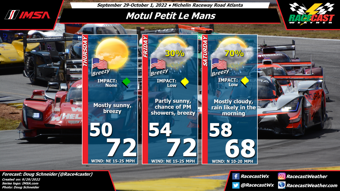
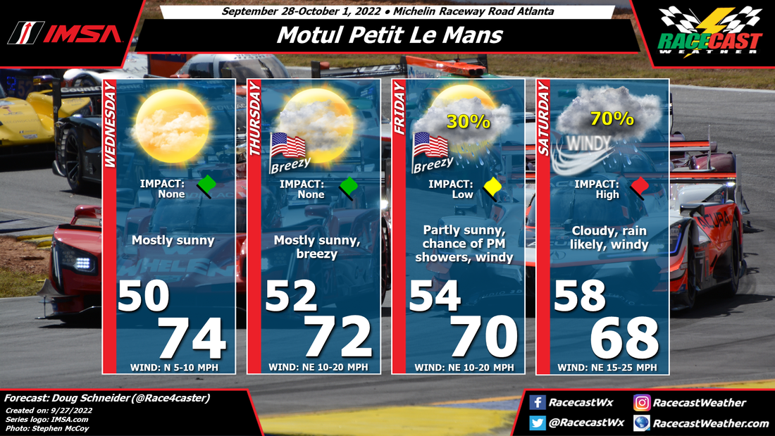
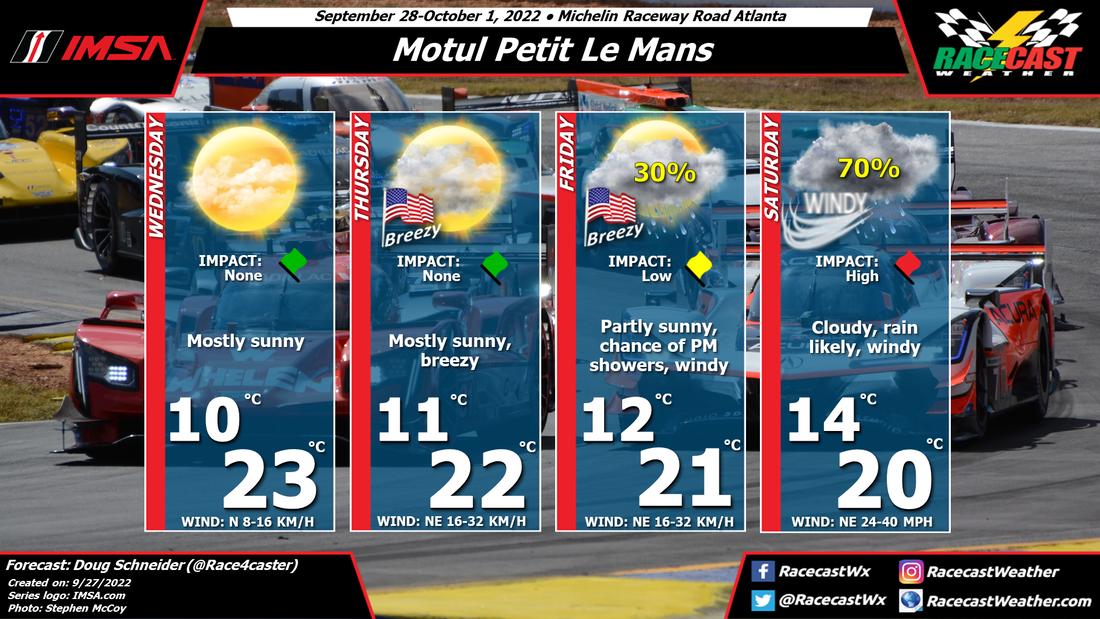
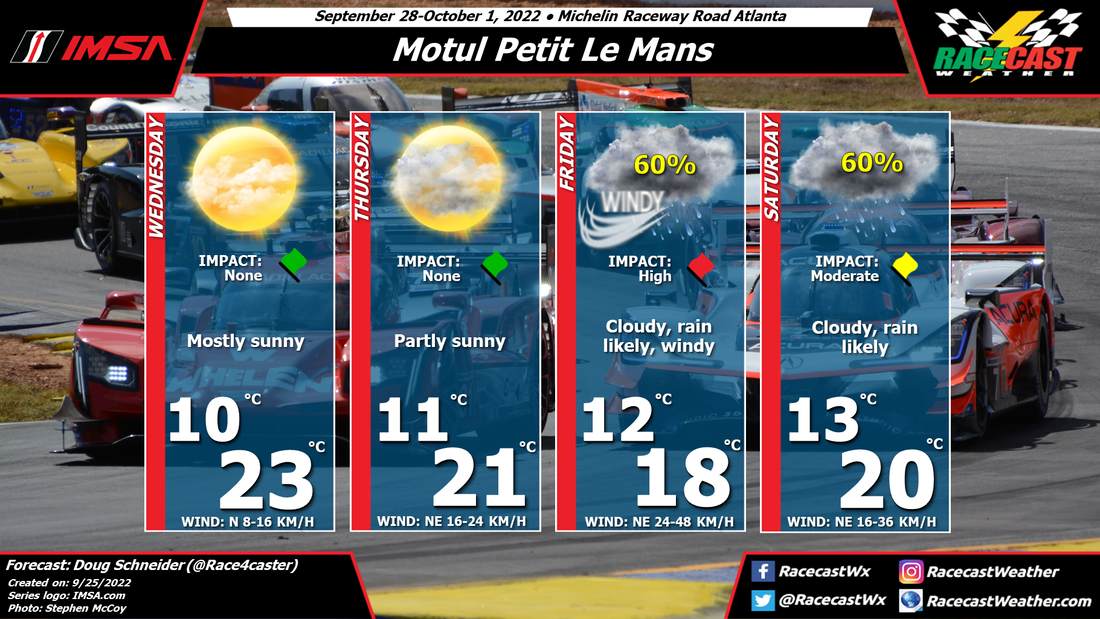
The forecast looks much better for Petit Le Mans today. The forecast track of Ian has shifted to the east, which will mean less of an impact on Road Atlanta. Another positive aspect of this forecast update is that most of the rain will fall on Friday night, with less impacts during the scheduled on-track times.

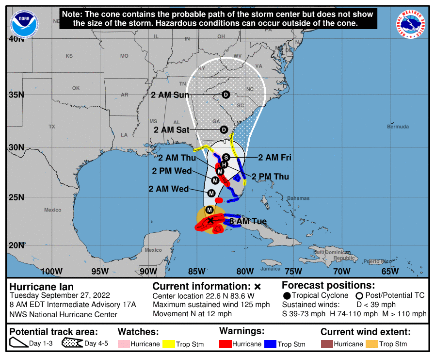
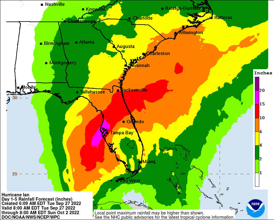
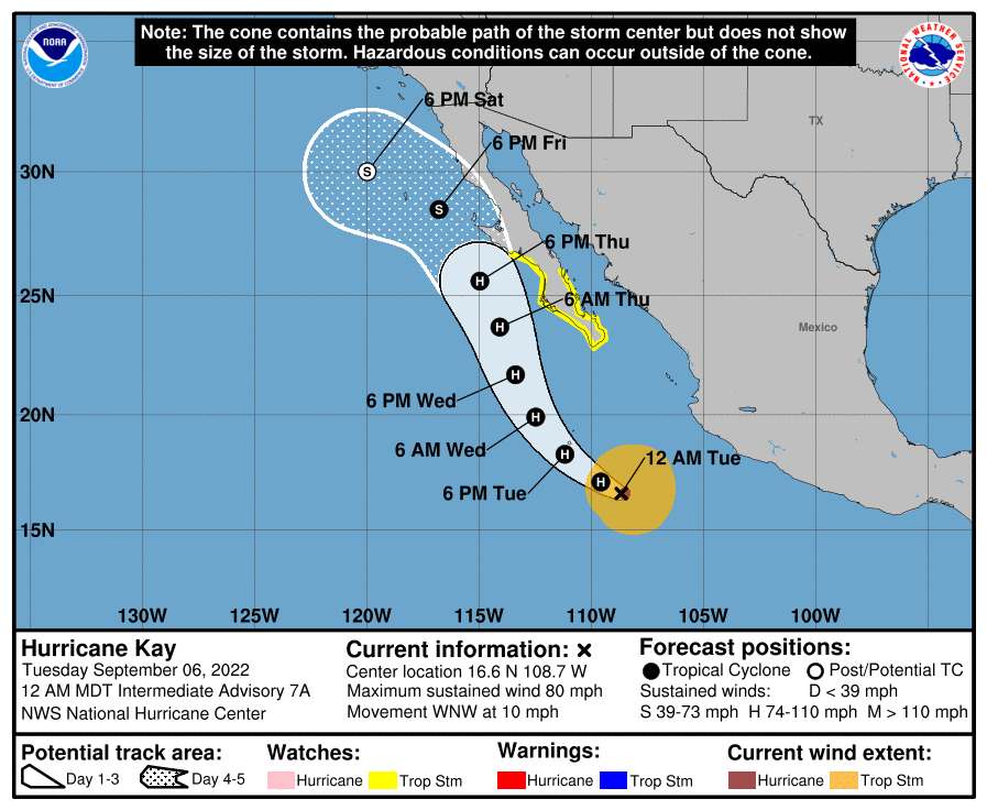
Here's the NWS forecast rainfall along the path of Ian through Sunday morning:
Picture
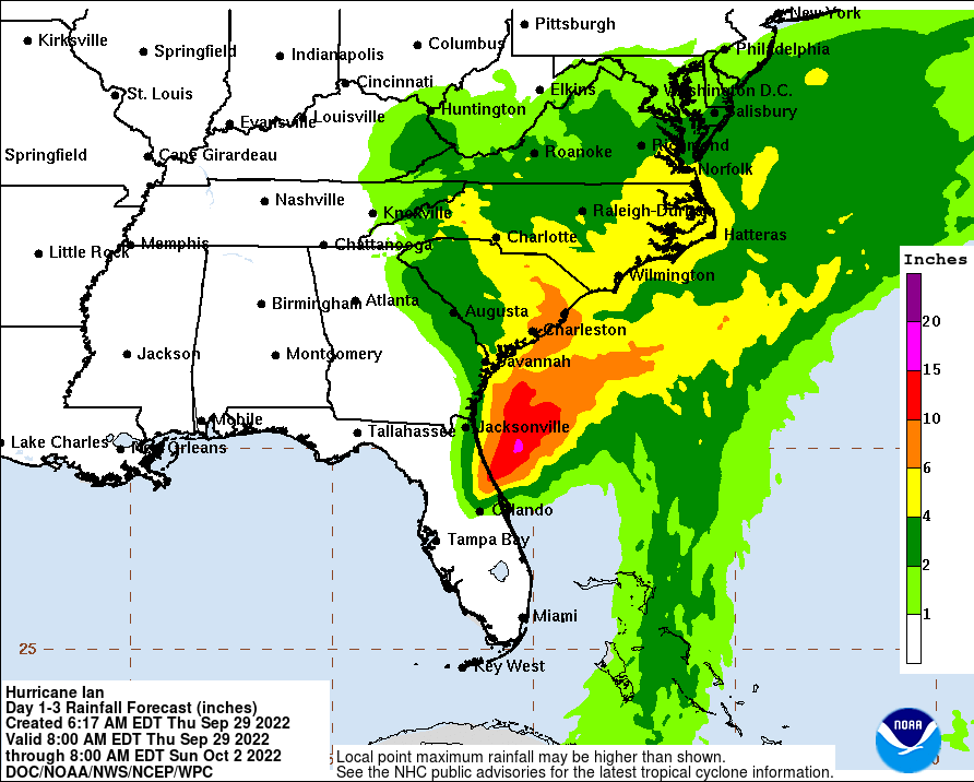
Road Atlanta is on the edge of the white and light green area. I expect that 1 inch of rain could be a high end amount, but the most likely rain amount will be around a half inch. This is much less than expected a few days ago when Ian was forecast to track directly across Georgia. 

Rain showers are expected to move into the area Friday afternoon, and increase in frequency through the evening. The WeatherTech qualifying session has the potential to have a shower, but I expect it to be light enough to allow the session to be held. Friday night won't be great for campers as rain picks up. Showers will continue to be on and off through Saturday morning, which could impact the morning warm up session. But the frequency and intensity of showers will be falling through the day, and I think all 10 hours of the race can be held without major disruption.

With the track of Ian being farther to the east, wind will not be as much of an impact. It will be breezy every day, with sustained winds of 15 to 25 mph, gusting between 30 and 35 mph at times. Objects will need to be secured to keep them from blowing around, but I don't think this should be a safety issue for campers. 
Comments

Initial Forecast for the Singapore Grand Prix

9/29/2022

Comments

 
By: Harris Cooley
Picture
It's looking like a rainy weekend for the Grand Prix as lower pressures lay over the area. Wind speeds will stay low as well as temperatures so these will not be a factor affecting the race too heavily. Storms in the area will be scattered and sporadic flowing in off the coast. The afternoons should be clearer with the highest chances of rain being in the morning. Overall, the tire selection will be the biggest strategy component for this weekend. A metric graphic is posted below... 
Picture
Comments

Tuesday forecast update for Motul Petit Le Mans

9/27/2022

Comments

 
By Doug Schneider

Key Messages and Impacts:

1) The remnants of Hurricane Ian will track across eastern Georgia on Saturday. Windy conditions will develop on Friday night and continue through Saturday. Sustained winds during this time are expected to be between 15 and 30 mph, with gusts of 40 to 45 mph. Possible impacts from the winds may be tree branches and/or weak trees blown down. This is a potential hazard for campers to be aware of and prepare for. Being in a tent on Friday night under trees may be hazardous; campers should consider finding sturdy shelter.
​
2) Rain is expected to spread into the area on Friday evening, with heavy rain at times from Friday night through Saturday. Between 2 and 4 inches is expected during that period, which may lead to flooding of low lying areas and small creeks and streams. There is a creek that runs behind the outer paddock area, past turn 1, and near the corner marshals' camping area. Camping near this creek should be avoided. 

​Forecast Discussion:

The main change to the forecast today is to push the timing of rain from the remnants of Ian later into Friday night and Saturday, to account for the slower forecast speed of Ian (click images to enlarge). 
Picture
Picture
The National Hurricane Center forecast as of 8 AM this morning is below. For the latest forecast from the NHC, click here.
Picture
The forecast has shifted to the east, which is somewhat good news for impacts at Road Atlanta. This track takes the storm inland sooner than if it made landfall father west along the Florida Panhandle. This extra time over land will cause the storm to weaker more before its effects are felt in northern Georgia. Still, it will be getting quite windy starting Friday night and continuing through Saturday. Gusts of 40 to 45 mph are expected, which may be strong enough to blow down some weak trees or tree branches.

​Below is the forecast rainfall graphic from the NWS Weather Prediction Center:
Picture
At Road Atlanta, between 2 and 4 inches of rain is forecast. Most of this is expected to fall from Friday night through Saturday afternoon. Avoid camping in low lying areas and near creeks, which will have a better chance of flooding. 

In terms of how the racing will be affected, it will be a question of when a heavy shower passes over the track, and whether the rain can run off the racing surface quickly enough to avoid ponding. I think it is likely that there will be some red flag periods during Saturday's race. It is possible that the rain could ease up enough late in the day on Saturday to allow for improving conditions for racing. But it's still early to pin that down with any confidence. 

Check back for updates, and be sure to follow @RacecastWx on Twitter, and RacecastWeather on Facebook and Instagram.
Comments

First forecast for Motul Petit Le Mans

9/25/2022

Comments

 
By Doug Schneider

Click on images below to enlarge
Picture
Picture
It's going to be a challenging week to forecast for Petit Le Mans. What is now Tropical Storm Ian in the Caribbean Sea is expected to track north and become a major hurricane as it moves into the Gulf of Mexico. Below is the forecast from the National Hurricane Center as of 5 pm EDT Sunday.
Picture
To better understand what the forecast cone means, here's a good graphic. 
Picture
The current NHC forecast track has the potential to produce significant impacts at Road Atlanta on Friday, Friday night, and Saturday. There are a couple scenarios that will affect how much impact Ian will have on the racing.

Scenario 1 - Ian takes a track toward the eastern edge of the forecast cone, and makes landfall in the Florida Peninsula, somewhere near Tampa, and tracks northeast, staying offshore of the Georgia coast. In this scenario, I expect minimal impacts to Road Atlanta. If this happens, there may be some showers and breezy conditions on Friday, but I think the racing would be able to be held on schedule.

Scenario 2 - Ian takes a track that is in the middle or on the western side of the forecast cone, making landfall along the Florida Panhandle, and into Georgia. If this happens, there may be significant wind and rainfall at Road Atlanta on Friday into Saturday. This could cause major disruptions to the racing schedule, as well as pose a possible threat of downed trees and flooding. This could be a safety hazard to people who are camping. 

As of today, I think Scenario 2 is the most likely one to happen. I don't know what IMSA can do to delay the event or reschedule, but the current forecast track and timing of Ian does not look good for holding a race with a track full of people in tents and campers. 

I've seen some comparisons on Twitter between this year and to the 2015 race. This weather pattern is nothing like what happened in 2015. That year, Hurricane Joaquin was well off the Atlantic coast, near the Bahamas, and a low pressure trough over the central U.S. was drawing moisture from Joaquin to the northwest. There was a band of tropical moisture that produced heavy rain over Road Atlanta, but it was not directly associated with Joaquin. There was also no impact from wind.
​
This situation is very different. This is expected to be a major hurricane that makes landfall on the Florida coast, and tracks directly into Georgia. The impacts from this system could be much more significant than 2015, especially in regard to wind. 

It is still early to say that any of this will happen with a high level of confidence, but the potential exists. I will have another post up here on Tuesday at the latest, but I will be posting on the @RacecastWx Twitter account every day with the latest forecast track and possible impacts on the event. 
Comments

First Look Forecast - SRO at Sebring

9/22/2022

Comments

 
By Scott Martin
Picture
Nothing out of the ordinary for Florida's weather this weekend, as the forecast will be pretty straight forward. Friday will be hot and muggy, with mostly clear skies. Temperatures will start off around 78 at 8 am and will rise to around 92 for the afternoon high. There is a small chance of an afternoon shower or storm, but that is only at 30%. It is the same story for Saturday and Sunday, with the only exceptions being the temperatures winding up a few degrees cooler. Highs on both days will be around 86 degrees. Only a small chance of an afternoon shower or storm on each day.
Comments

Forecast update for the Firestone Grand Prix of Monterey

9/8/2022

Comments

 
By Doug Schneider
Picture
All eyes on are what will happen with Hurricane Kay and how it might impact the INDYCAR season finale at WeatherTech Raceway Laguna Seca. 

Hurricane Kay is forecast to track up the northwest coast of Mexico today and Friday, and weaken to a tropical storm. By Saturday night, it will be off the coast of San Diego, and start to curve toward the west. While the remnants of Kay won't have a direct impact on Monterey, it will have the effect of spreading moisture into the area. Whether there will be enough moisture to produce some rain at the track is uncertain, but it is at least a possibility, so I've added a small chance of rain to Sunday's forecast. I am confident that moisture from Kay will increase cloud cover on Saturday and Sunday, which will make for pleasant temperatures with highs in the mid 70s. 
Comments

Initial Forecast for the Italian Grand Prix

9/6/2022

Comments

 
By: Harris Cooley
Picture
We're in for a mixture of weather conditions for this weekend at the historic Monza. A Low pressure system will be moving though the area early Friday morning likely bringing consistent rain storms into the afternoon. The rain chances go down by Saturday as this Low moves south giving way to clearer skies and light winds for race day. Nice calm conditions will be present for Sunday with mostly sunny skies and moderate temps. A metric graphic is posted below...
Picture
Comments

Initial forecast for the Firestone Grand Prix of Monterey

9/6/2022

Comments

 
By Doug Schneider
Picture
Hard to believe the INDYCAR season finale is already here. It's been a great season, and the finale should be very exciting with multiple drivers in contention for the championship. The weather should cooperate and not impact the race, but there are some uncertainties to the forecast that aren't shown in the graphic.

A large high pressure system will cover the western U.S. on Friday, and provide a sunny and warm day at the track. Meanwhile, Hurricane Kay will be tracking northward off the west coast of the Baja Peninsula. Below is the National Hurricane Center's forecast for Kay through Saturday. 
Picture
As you can see in the graphic, Kay is expected to take a northwesterly turn on Saturday, and it will likely stay well south and west of Monterey through Sunday. The main effect of Kay will be to increase clouds on Saturday and Sunday. I have seen some forecasts that have a chance of showers in the Monterey area on Sunday, based on Kay taking a track that stays closer to the California coast and spreading some moisture into the area. But I think it is more likely that the large high pressure ridge over the western U.S. will steer Kay away from the coast. So I can't completely rule out a shower on Sunday, but I think the chance is very low at this time. I'll have another update posted later this week before the event begins. 
Comments
<<Previous

    Social Feeds


    Instagram


    Authors

    Doug Schneider
    Scott Martin
    Stephen McCoy

    Harris Cooley 


    Partners

    Picture
    Picture
    Picture
    Picture
    Picture

    Categories

    All
    F1
    IGTC
    IMSA
    Indycar
    Le Mans
    MRTI
    NASA
    Outlooks
    Photos
    PWC
    Racecasts
    SCCA
    SRO
    Trans Am
    TUSC
    Verification
    Weather Education
    WEC


    Archives

    March 2023
    February 2023
    January 2023
    December 2022
    November 2022
    October 2022
    September 2022
    August 2022
    July 2022
    June 2022
    May 2022
    April 2022
    March 2022
    February 2022
    January 2022
    December 2021
    November 2021
    October 2021
    September 2021
    August 2021
    July 2021
    June 2021
    May 2021
    April 2021
    March 2021
    January 2021
    December 2020
    November 2020
    October 2020
    September 2020
    August 2020
    July 2020
    June 2020
    March 2020
    January 2020
    December 2019
    November 2019
    October 2019
    September 2019
    August 2019
    July 2019
    June 2019
    May 2019
    April 2019
    March 2019
    February 2019
    January 2019
    December 2018
    November 2018
    October 2018
    September 2018
    August 2018
    July 2018
    June 2018
    May 2018
    April 2018
    March 2018
    February 2018
    January 2018
    December 2017
    November 2017
    October 2017
    September 2017
    August 2017
    July 2017
    June 2017
    May 2017
    April 2017
    March 2017
    February 2017
    January 2017
    December 2016
    November 2016
    October 2016
    September 2016
    August 2016
    July 2016
    June 2016
    May 2016
    April 2016
    March 2016
    February 2016
    January 2016
    December 2015
    November 2015
    October 2015
    September 2015
    August 2015
    July 2015
    June 2015
    May 2015
    April 2015
    March 2015
    February 2015
    January 2015
    December 2014
    November 2014
    October 2014
    September 2014


Powered by Create your own unique website with customizable templates.