Racecast Weather - Your Source for Race Weather Information
  • Home
  • Racecasts
  • 2023 Schedule
  • Services
  • Contact
  • Bios
  • Links

Initial Forecast for the Acura Sports Car Challenge at Mid-Ohio

4/29/2019

Comments

 
By: Stephen McCoy
Picture
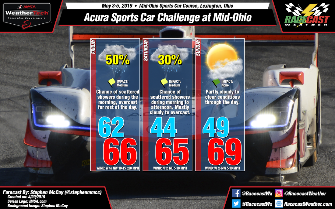
Cool and cloudy seems to be the mantra of this weekend for the Acura Sports Car Challenge at Mid-Ohio with some precipitation in the mix for Friday and Saturday.

During the week an upper level longwave trough will move eastward through the northern region of the U.S. contiguous 48. On Wednesday, a surface low pressure system is expected to form on the eastern side of the Rockies, tracking northeastward into eastern Canada by Saturday. The system will reach central Ohio on Thursday, with a warm front causing precipitation during the afternoon and into the night and a cold front passing through which will cool temperatures for Friday. Depending on the timing of the cold front passage, rain could be possible during the morning. One thing to note is this system is the second low that will move through the region this week, with the first moving through on Wednesday.

While this low is moving through between Thursday and Friday, a shortwave trough in the mid-to-upper levels will move through the southern Plains, spawning another low pressure system at the surface which is expected to move eastward towards the Atlantic. Recent models runs indicate the low will remain to the south of central Ohio on Saturday, which will continue to bring cool air to the region albeit from the northeast. Moisture in the much of the atmosphere could be transported to the region by southwesterly winds and bring a chance for scattered showers during the morning to mid-afternoon.

For Sunday, an upper level ridge is expected to move in behind the trough, bringing drier air to the region which will break up most of the cloud cover.

There is a lot of model disparity in this forecast, especially concerning the timing and location of fronts associated with these systems, so I'm expecting changes for the next update on Wednesday.
Comments

First forecast for the WEC Six Hours of Spa-Francorchamps

4/29/2019

Comments

 
By Doug Schneider
Picture
Picture
I have to say that in the five years that I've been making forecasts for races around the world, this forecast for the Six Hours of Spa ranks near the top for the worst expected weather conditions. Cold and wet weather is expected every day, and there will even be a chance of snow on Saturday morning.

The beginning portions of the week actually look quite nice across Belgium, but that will chance significantly in the later half of the week. A large and deep low pressure trough is expected to drop southward into Scandinavia on Thursday, which will push a cold front through northern Europe, approximately in the Thursday night to Friday morning time frame. Rain is likely across Belgium on Thursday ahead of this front, mainly in the afternoon. Rain amounts on Thursday are expected to be around 4 mm or 0.15 inches. This probably won't be enough to cause a big impact on the practice sessions, but there could be some delays. 

The cold front is expected to be passing through on Friday morning, shifting winds to a more northerly direction that will bring a colder air mass to the area. Temperatures will remain in the 40s on Friday. Periods of rain will continue as the upper level low pressure trough sits over the Baltic Sea. Rain amounts will likely be in the range of 2 to 5 mm (0.1 to 0.2 inches) on Friday.

A second cold front is expected to move into the area Friday night, which will drop temperatures even further, with lows in the 30s Saturday morning. It may be cold enough for precipitation to fall as snow. At this time, I don't think there will be any snow accumulation, as temperatures should remain just above freezing at the surface, and any snow should change to rain by midday. Wet and cold conditions for the race will be a challenge for teams and fans to deal with on Saturday. I expect that tire temperatures will be the story of the day. Forecasting rain amounts this far out is difficult, but amounts in the range of 3 to 6 mm (a tenth to a quarter inch) appear most likely at this time on Saturday.

Hopefully I can bring better news with the next forecast update, which I expect to have posted on Wednesday morning.
Comments

Saturday update for Blancpain GT World Challenge America at VIR

4/27/2019

Comments

 
By: Stephen McCoy
Picture
The cold front mentioned in previous forecasts will bring a slight chance for scattered showers to the region overnight. Recent model output suggests totals only around a few hundredth's of an inch, so the largest impact for Sunday's on track sessions might be some damp areas early. The cold front is not expected to pass through the region until the late afternoon or evening, allowing plenty of time for temperatures to warm to the upper 70's. Mostly cloudy conditions are expected overnight, with partly cloudy skies expected during the day; clouds will be mostly in the mid-to-upper levels. Windy conditions are likely with some stronger gusts possible, maximum winds will occur on the edge of the front; until the front passes, winds will be from the west to southwest.
Comments

Friday update for Blancpain GT World Challenge America at VIR

4/26/2019

Comments

 
By: Stephen McCoy
Picture
No major changes to the forecast for Blancpain GT World Challenge at VIRginia International Raceway. Temperatures will dip into the upper 40's tonight and tomorrow morning as northwesterly winds bring cooler air to the region. With plenty of sunshine on Saturday, temperatures are expected to rebound nicely with an afternoon high in the lower 70's. Some winds with stronger gusts are possible during the day as both surface and low level winds will be out of the west to northwest.

There is a slight chance for scattered showers overnight and into Sunday ahead of a cold front approaching from the northwest, but otherwise no precipitation is expected. The cold front, in addition to a high pressure system off the east coast, will cause some stronger winds again through the day. Air temperatures will be warmer in the upper 70's due to southwesterly winds, but with relative humidity around 40% temperatures may feel a degree or two cooler. Mostly cloudy conditions will move in overnight, decreasing during the day; for the most part cloud cover will be in the mid-to-upper levels.
Comments

Wednesday update for Blancpain GT World Challenge America at VIR

4/24/2019

Comments

 
By: Stephen McCoy
Picture
In general terms, this update for Blancpain GT World Challenge America at VIR is similar to the initial forecast, with Friday looking the worst of the weekend before much more favorable conditions on Saturday and Sunday.

An upper level shortwave trough is still expected to develop over the northern plains region of the U.S., deepening as it tracks eastwards across the country. At the surface, a low pressure system will form in the eastern side of the Rockies, over the Wyoming/Nebraska border and will move towards the Northeast through Saturday. A cold front from the system will affect southern Virginia on Friday as the low approaches New England. Model output suggests precipitation may begin overnight Thursday ahead of the front, with rain persisting for much of the day. An upward trend in the models has shown an increase in CAPE (atmospheric instability) and, as a result, thunderstorm potential for Friday afternoon, with values reaching above 1000 J/kg. Periods of heavy rain and/or lightning could halt track activities during the afternoon sessions. As referenced in the picture below, the National Weather Service's Storm Prediction Center currently has much of Southeast Virginia in a Marginal risk for severe weather on Friday. Look for updates on the Racecast Weather Twitter if the categorical outlook increases in the next day or two. The front will bring strong winds from the southwest; some gusts could reach upwards of 25 mph.
Picture
After the front moves through the region Friday evening, winds will shift to the west/northwest at the surface which will result in much drier conditions for Saturday and Sunday; relative humidity is expected to be less than 40% both days. In the upper levels, winds will also bring in drier air from the west/northwest, causing plenty of sunshine throughout the day on Saturday.

Another shortwave trough is expected to track through the Midwest overnight Saturday, which will shift upper level winds to the west/southwest, bringing some moisture back to the region. The increased moisture will cause some heavy upper level cloud cover overnight, and may persist into the morning, though the cloud cover should decrease into the afternoon. Ahead of the trough, another surface low pressure system is likely to develop in the lee-side of the Rockies, tracking in a similar direction to the system on Friday. A cold front is expected to approach southern Virginia on Sunday from the north, however no precipitation is expected with this system.
Comments

Initial Forecast for Blancpain GT World Challenge America at VIR

4/22/2019

Comments

 
By: Stephen McCoy
Picture
Wednesday evening, an upper level shortwave trough is expected to develop over northern Montana, along the U.S./Canadian border, and will deepen as it propagates eastward through Friday. A surface low pressure system will form over the Midwest ahead of the trough, tracking to the northeast in the same time frame. Precipitation ahead of a cold front extending to the southwest from the surface low will likely affect on track activities to some extent on Friday. Surface winds ahead of the front are expected out of the southwest at 10-15 mph; low level winds from the same direction will cause some stronger gusts upwards of 20 mph. After the front passes, winds will shift to the northwest as temperatures cool to the mid 50's for Saturday morning.

Behind the surface low, an area of high pressure will build in over the Midwest, bringing calmer winds from the northeast. Dry air will move in through the atmosphere behind the front, with clear conditions expected for much of Saturday. Late Friday into Saturday, another surface low pressure system will form off the eastern side of the Rockies and will track eastward across the U.S towards New England. A cold front will approach southern Virginia from the north on Sunday, however at the moment no precipitation is expected to reach the track. Southwesterly surface winds will warm temperatures to the mid-70's while west/southwesterly winds in the mid-to-upper levels result in partly cloudy conditions through the day.
Comments

Friday forecast update for the Acura Grand Prix of Long Beach

4/12/2019

Comments

 
By Doug Schneider
Picture
Another day of beautiful southern California weather is expected on Saturday, with lots of sunshine and warm temperatures. Winds will be shifting to the southwest through the day. This will have an impact on Sunday's weather. With the winds shifting to an onshore direction, moisture will increase and allow for fog and low clouds to develop Saturday night. Fog and clouds will linger into Sunday morning, but I don't think it will be dense enough to deter any of the on-track activities. Any fog should lift by mid-morning, and the clouds should dissipate by early afternoon. With the onshore winds and partial cloud cover, temperatures will be cooler compared to Saturday, with highs near 70,
Comments

Wednesday forecast update for the Acura Grand Prix of Long Beach

4/10/2019

Comments

 
By Doug Schneider
Picture
Not much has changed from my initial forecast for Long Beach, as beautiful weather is still expected each day of the event. 

The weather pattern shown by the models continues to feature a mid and upper level low pressure trough that will be taking shape over Arizona and northern Mexico on Friday. Long Beach will be on the western side of this trough, under the influence of a dry and cool northwesterly flow. The only impact from this system will be breezy conditions on Friday, with a northwest wind between 10 and 20 mph, gusting to 25 mph at times.

As the low pressure system departs and high pressure builds in, winds will become lighter on Saturday, and temperatures will get a little bit warmer, with highs reaching the lower 70s. 

Another weak upper level trough approaches the area on Sunday, and it may bring a little more cloud cover, but not enough to produce any rain. Winds will be light on Sunday, and high temperatures will reach close to 70. 
Comments
<<Previous

    Social Feeds


    Instagram


    Authors

    Doug Schneider
    Scott Martin
    Stephen McCoy

    Harris Cooley 


    Partners

    Picture
    Picture
    Picture
    Picture
    Picture

    Categories

    All
    F1
    IGTC
    IMSA
    Indycar
    Le Mans
    MRTI
    NASA
    Outlooks
    Photos
    PWC
    Racecasts
    SCCA
    SRO
    Trans Am
    TUSC
    Verification
    Weather Education
    WEC


    Archives

    March 2023
    February 2023
    January 2023
    December 2022
    November 2022
    October 2022
    September 2022
    August 2022
    July 2022
    June 2022
    May 2022
    April 2022
    March 2022
    February 2022
    January 2022
    December 2021
    November 2021
    October 2021
    September 2021
    August 2021
    July 2021
    June 2021
    May 2021
    April 2021
    March 2021
    January 2021
    December 2020
    November 2020
    October 2020
    September 2020
    August 2020
    July 2020
    June 2020
    March 2020
    January 2020
    December 2019
    November 2019
    October 2019
    September 2019
    August 2019
    July 2019
    June 2019
    May 2019
    April 2019
    March 2019
    February 2019
    January 2019
    December 2018
    November 2018
    October 2018
    September 2018
    August 2018
    July 2018
    June 2018
    May 2018
    April 2018
    March 2018
    February 2018
    January 2018
    December 2017
    November 2017
    October 2017
    September 2017
    August 2017
    July 2017
    June 2017
    May 2017
    April 2017
    March 2017
    February 2017
    January 2017
    December 2016
    November 2016
    October 2016
    September 2016
    August 2016
    July 2016
    June 2016
    May 2016
    April 2016
    March 2016
    February 2016
    January 2016
    December 2015
    November 2015
    October 2015
    September 2015
    August 2015
    July 2015
    June 2015
    May 2015
    April 2015
    March 2015
    February 2015
    January 2015
    December 2014
    November 2014
    October 2014
    September 2014


Powered by Create your own unique website with customizable templates.