Racecast Weather - Your Source for Race Weather Information
  • Home
  • Racecasts
  • 2023 Schedule
  • Services
  • Contact
  • Bios
  • Links

First forecast for Trans Am at the Keystone Speedfest presented by Lux Performance

7/30/2018

Comments

 
By Doug Schneider
Picture
The Pittsburgh International Race Complex is a new location for our forecasts. Trans Am will be part of a big race weekend that will also feature the F3, F4, F1600, F2000, and Formula Atlantic championships. So if you're in the western PA area, be sure to get out and enjoy some great racing. The weather looks like it will cooperate over the weekend. 

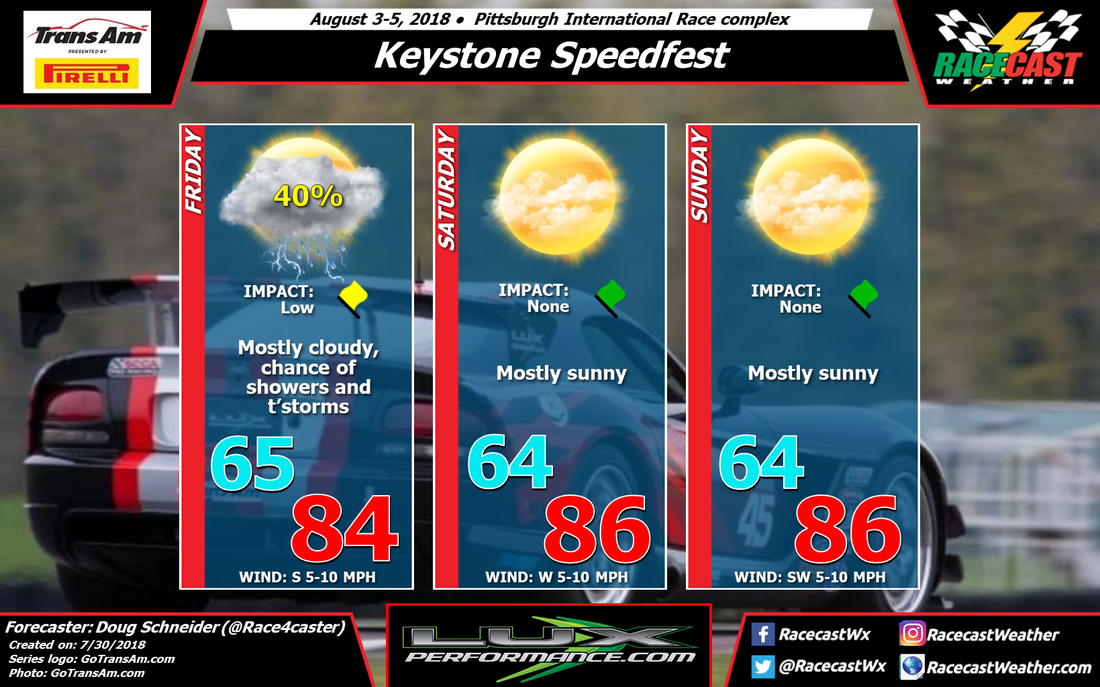
On Friday, there will be a low pressure trough that will be moving across the Great Lakes region, which will pick up moisture from the south and spread it across Pennsylvania through the day. The majority of this moisture will be in central and eastern PA, with the Pittsburgh area in the western edge of it. This keeps some uncertainty in the forecast regarding how much rain (if any) will be at the track on Friday, but for now I have a 40% chance in the forecast. With only a slight shift one way or the other, that rain chance could rise or lower in the next few days, so stay tuned. 

The models are in pretty good agreement that the rest of the weekend will stay dry. Behind the departing trough, a large high pressure ridge off the east coast will build across the Southeast and Mid Atlantic region. This should steer any disturbances in the flow well north of the Pittsburgh area, and provide mostly sunny skies and warm temperatures in the mid 80s. 
Comments

First Look Forecast For IMSA At Road America

7/30/2018

Comments

 
​By Scott Martin.
Picture
​A wave of energy will be sweeping through the area on Thursday that may allow for a few isolated to scattered showers throughout the daylight hours. The good news is that rain chances appear to be very small at this point, around 20%. We'll have more clouds than sun and the high will top out in the upper 70s. Winds will be out of the west-southwest at 5-10 MPH.

High pressure will dominate the weather for Friday and Saturday, and with that happening, you will notice a rise to those afternoon highs. We'll have mostly clear skies on both days with Friday's high topping out around 80 degrees, and Saturday's high in the upper 80s. An approaching low will cause a tightening in the pressure gradient on Saturday, so winds will be a little breezy out of the southwest averaging 10-15 MPH.

That approaching low over the Dakotas may allow for a few isolated showers to form nearby during the late afternoon and into the early evening hours, and one may pass over the track before the end of the race day on Saturday, but the chances of that occurring will be around 20%.

Sunday will be another very warm day with breezy winds as that low pressure center weakens and moves across the southern parts of Minnesota. This will continue to be the catalyst for a few isolated showers to develop during the afternoon hours. Rain chances at this point are still very small, around 20%. Afternoon highs will be back up into the mid-80s with winds out of the southwest at 10-15 MPH.
Comments

Race day forecast for the Honda Indy 200

7/28/2018

Comments

 
By: Stephen McCoy
Picture
Low level cloud cover will likely dominate the day, with conditions starting clear to partly cloudy in the morning, then transitioning to more heavier cloud cover into the afternoon and evening. Moisture in the lower levels will remain over much of central Ohio through the day as light winds will be present, resulting in the cloudy conditions. Surface winds will be variable, starting from the south to southwest before moving to the north to northeast towards the end of the day; the shift in winds is primarily caused by an area of high pressure at the surface slowly tracking northeastward from the Midwest into New England.
Comments

Race day forecast for the 24 Hours of Spa

7/28/2018

Comments

 
By Doug Schneider

A look at the radar this morning across France and Belgium shows a line of showers and thunderstorms moving east. This will affect Spa-Francorchamps through the morning. It will likely produce between a tenth and a quarter inch of rain, or between 3 and 6 mm. The chance of rain is expected to taper off in the late morning and early afternoon, and I expect all the rain to be out of the area by around 2 pm. This should give dry conditions for the start of the race at 4:30 pm. 

There will be quite a bit of cloud cover remaining overhead through the overnight hours. There will be a full moon, but it likely won't be seen very much. The cloud cover should start to diminish late Sunday morning and Sunday afternoon, with partly cloudy skies by the end of the race. 
Picture
Picture
Comments

Friday update for the Honda Indy 200

7/27/2018

Comments

 
By: Stephen McCoy
Picture
As a longwave upper level trough track eastward over the northeast and Mid-Atlantic states, upper level winds over the Midwest will continue from the west to northwest on Saturday, bringing dry air into the region and keeping upper level conditions clear. Moist air in the low levels of the atmosphere will likely result in partly cloudy conditions for much of the day, with cloud cover increasing as the day progresses. High pressure at the surface will continue to slowly move into the region, keeping temperatures below normal through light winds from the west and northwest.

The area of high pressure is expected to build in over central Ohio on Sunday, causing variable shifts in the wind direction at the surface. Low level winds will continue to bring moisture and cloud cover into the region; however at the upper levels, winds will shift to the southwest. This will also bring moisture into central Ohio and increase cloud cover for the day.
Comments

Thursday forecast update for the 24 Hours of Spa

7/26/2018

Comments

 
By Doug Schneider
Picture
Click to enlarge
Picture
Click to enlarge
There will be quite a big swing in weather conditions for the Total 24 Hours of Spa. The first forecast I made on Monday still looks generally on track, with the highest chance of rain continuing to be on Saturday. Some of the finer details of timing and rain amounts are coming into better focus today.

This afternoon at Spa-Francorchamps, temperatures will be quite warm, reaching well into the lower 90s F/lower 30s C. With this heating will come some instability that will allow for scattered showers and thunderstorms to develop in the area. Whether one of them will hit the circuit remains to be seen, but I'd put the chances of that at 30%. If it does, there may be lightning and heavy rain for a brief period. 

Friday looks more stable with a little more dry air through the lower and midlevels of the atmosphere. This should prevent afternoon storms from developing. Temperatures will still be quite warm, with highs near 90 F/32 C.

Rain will start to spread into the area from the west on Saturday morning as a cold front and a deep upper level trough swing through the area. I expect that the onset of rain will occur around 7 am CEST, give or take a couple hours either way. Periods of rain showers will continue through the morning and the early afternoon, with rain diminishing in the afternoon as the upper trough moves east. The most likely time frame for the majority of the rain will be between 8 am and 2 pm, with a few light showers possible after 2 pm until 8 pm. The total amount of rain to expect on Saturday will be between 0.15 and 0.3 inches, or between 4 and 8 mm. Temperatures will be much cooler behind the front with cloudy skies all day, only reaching the mid 70s F/ mid 20s C. 

Sunday should be a much nicer day for the finish of the race. It will be cool overnight, with a low in the upper 50s F/mid teens C, then partly cloudy skies and temperatures in the upper 70s F/mid 20s C during the day. 
Comments

Wednesday update for the Honda Indy 200

7/25/2018

Comments

 
By: Stephen McCoy
Picture
The most notable change to the forecast in this update is the addition of a slight chance for showers on Friday afternoon. A cold front is still expected to move eastward through the Midwest Thursday night into Friday morning, bringing a chance for rain in the early morning and is the cause for the below normal temperatures for the weekend. Where the forecast differs from Monday's forecast is in the low to mid levels in the atmosphere, where more moist air is expected during the day. The result is a slight chance of scattered showers in central Ohio around the time of the second practice session.

However, something to mention is the models are in slight disagreement with the potential for precipitation during the day on Friday, with the GFS and ECMWF both indicating a slight chance while the NAM shows drier air in the mid levels and at the surface and no precipitation. My confidence for Friday's chances for precipitation is around 50/50, due primarily to the dispute among the models. The next update should provide a clearer picture for precipitation chances.

Conditions remain mostly consistent for Saturday and Sunday, though in contrast to the previous forecast, the GFS and ECMWF show drier air over the region on Sunday. Because of this, precipitation chances drop off with temperatures slightly lower than the previous forecast.
Comments

Initial forecast for the Honda Indy 200

7/23/2018

Comments

 
By: Stephen McCoy
Picture
Below normal temperatures are expected for this weekend's Honda Indy 200 at Mid-Ohio Sports Car Course with some slight chances of scattered showers that shouldn't affect the on-track action as of now.

A cold front associated with a low pressure system over eastern Canada will move eastward through the Midwest Thursday night into early Friday morning, bringing a slight chance of scattered showers into the area. Westerly wind behind the front at the surface and northwesterly winds in the low to mid levels of the atmosphere will bring cooler air into the region relative to average temperatures for this time of year. Partly cloudy conditions are likely during the day on Friday, with most cloud cover located in the lower levels.

Behind the cold front, an area of high pressure will build into the Midwest late Friday and into Saturday. With the center of the system to the west of the track, winds will be primarily from the north and northwest during the day on Saturday, bringing cool air into the region from southern Canada. Moist air in the lower and upper levels of the atmosphere means some heavier cloud cover will persist for much of the day, but with the high pressure system, any chance of precipitation is unlikely.

I'm not very confident about Sunday's forecast and I expect it to change during the week. At the moment, the GFS and ECMWF models disagree about the conditions on Sunday, as the GFS indicates a chance for scattered showers while the ECMWF keeps conditions dry. The GFS shows a warm front extending from a low pressure system in the southern plains, with winds from the south bringing warm, moist air to the region. The ECMWF doesn't include the same system in its latest run and shows easterly winds for Sunday. Again, I expect things to change once more model data is available so look later in the week for a more definitive forecast.
Comments
<<Previous

    Social Feeds


    Instagram


    Authors

    Doug Schneider
    Scott Martin
    Stephen McCoy

    Harris Cooley 


    Partners

    Picture
    Picture
    Picture
    Picture
    Picture

    Categories

    All
    F1
    IGTC
    IMSA
    Indycar
    Le Mans
    MRTI
    NASA
    Outlooks
    Photos
    PWC
    Racecasts
    SCCA
    SRO
    Trans Am
    TUSC
    Verification
    Weather Education
    WEC


    Archives

    March 2023
    February 2023
    January 2023
    December 2022
    November 2022
    October 2022
    September 2022
    August 2022
    July 2022
    June 2022
    May 2022
    April 2022
    March 2022
    February 2022
    January 2022
    December 2021
    November 2021
    October 2021
    September 2021
    August 2021
    July 2021
    June 2021
    May 2021
    April 2021
    March 2021
    January 2021
    December 2020
    November 2020
    October 2020
    September 2020
    August 2020
    July 2020
    June 2020
    March 2020
    January 2020
    December 2019
    November 2019
    October 2019
    September 2019
    August 2019
    July 2019
    June 2019
    May 2019
    April 2019
    March 2019
    February 2019
    January 2019
    December 2018
    November 2018
    October 2018
    September 2018
    August 2018
    July 2018
    June 2018
    May 2018
    April 2018
    March 2018
    February 2018
    January 2018
    December 2017
    November 2017
    October 2017
    September 2017
    August 2017
    July 2017
    June 2017
    May 2017
    April 2017
    March 2017
    February 2017
    January 2017
    December 2016
    November 2016
    October 2016
    September 2016
    August 2016
    July 2016
    June 2016
    May 2016
    April 2016
    March 2016
    February 2016
    January 2016
    December 2015
    November 2015
    October 2015
    September 2015
    August 2015
    July 2015
    June 2015
    May 2015
    April 2015
    March 2015
    February 2015
    January 2015
    December 2014
    November 2014
    October 2014
    September 2014


Powered by Create your own unique website with customizable templates.