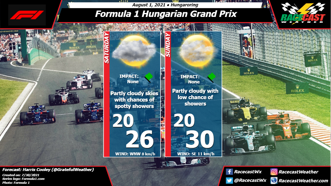
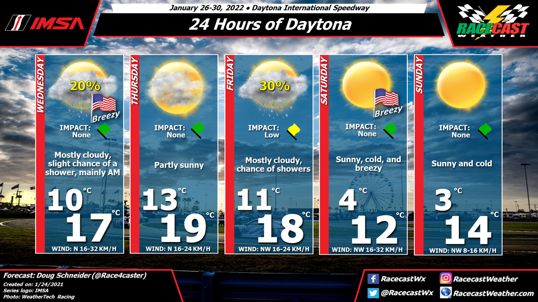
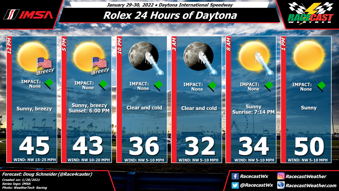
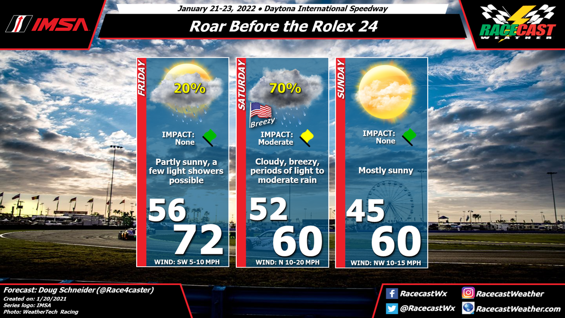
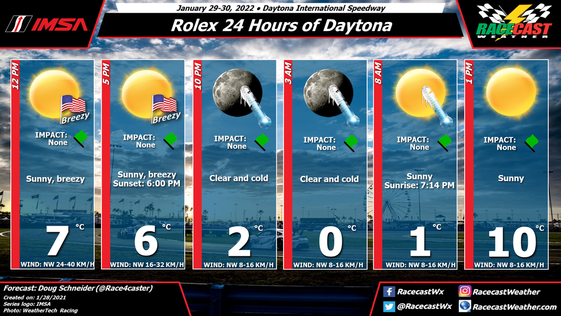
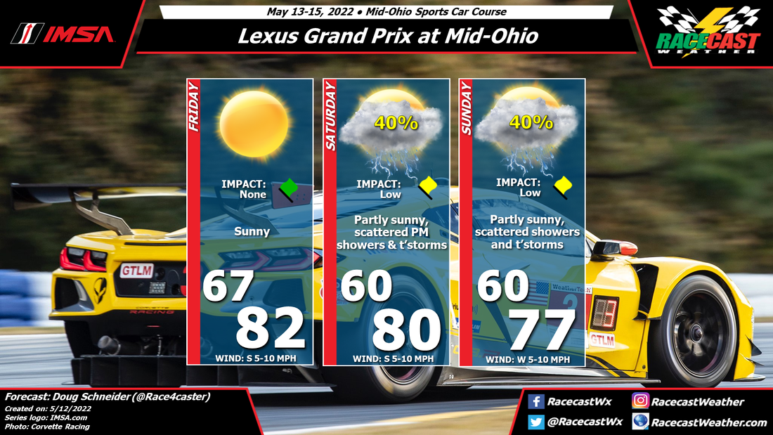
The hot temperatures and atmospheric instability will fuel these storms through the afternoons with rapid genesis and dissipation, so it will be imperative to watch the radar throughout the race. Rain or shine, it will be a fantastic race with tensions running high at this point in the season! A metric graphic is displayed below...
|
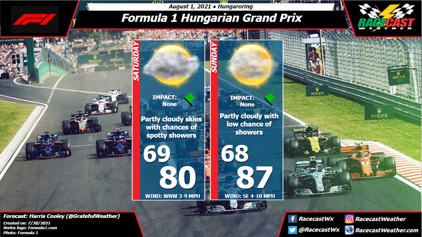
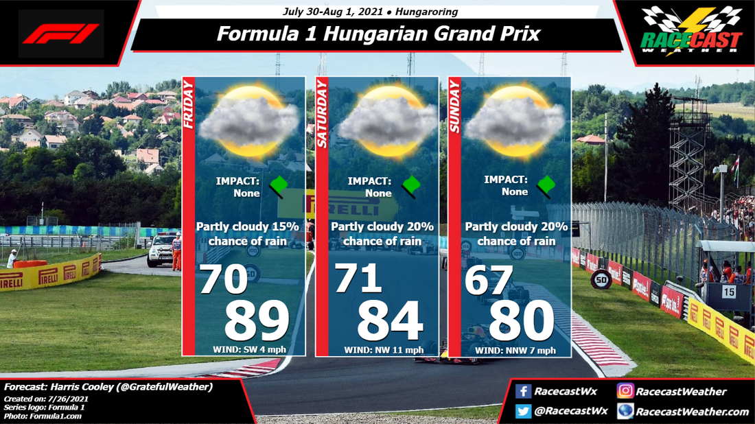
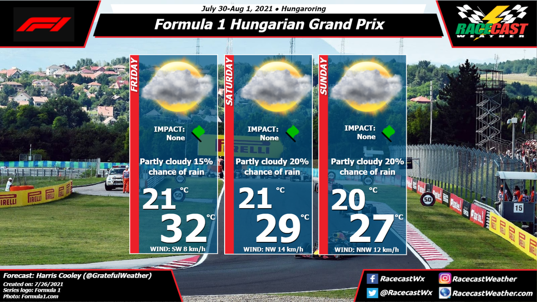
By: Harris Cooley The forecast has remained mostly the same with warm temperatures and spotty showers around the area. Saturday presents the biggest risk of an afternoon shower with chances going down by Sunday. We saw a pop-up shower make the track wet around this time last year for the GP and it is looking like this could be a plausible scenario for this year's race as well.
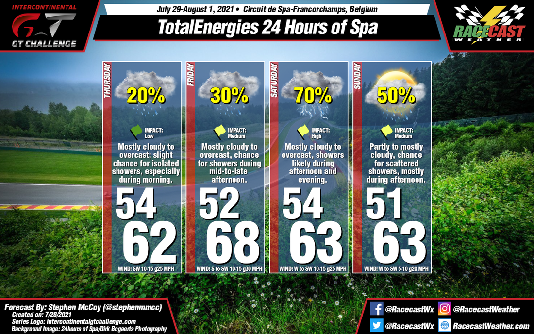
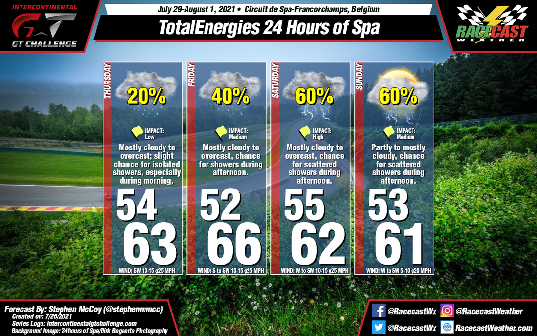
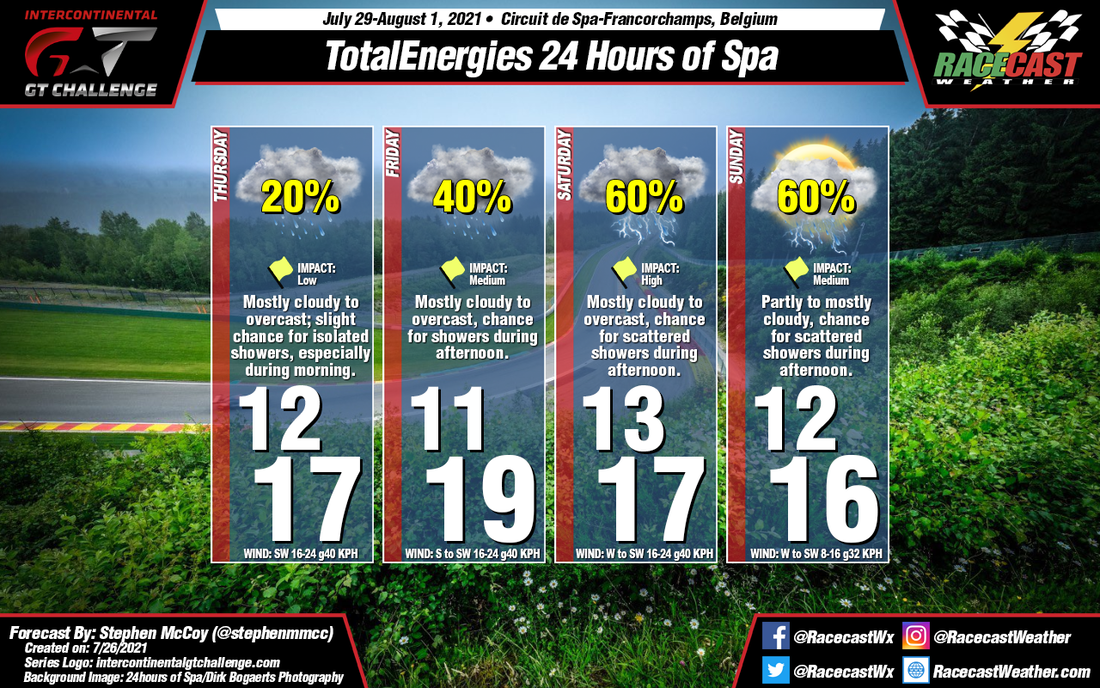
The hot temperatures and atmospheric instability will fuel these storms through the afternoons with rapid genesis and dissipation, so it will be imperative to watch the radar throughout the race. Rain or shine, it will be a fantastic race with tensions running high at this point in the season! A metric graphic is displayed below... By: Stephen McCoy Conditions have remained mostly similar to those expected from Monday for the Spa 24 Hour. On Thursday and Friday, a surface low pressure system will pass to the north of the region, moving into Scandinavia in the latter part of the weekend. Winds moving cyclonically around the low will bring in moisture from the southwest to the region, resulting in mostly cloudy to overcast skies. Both days will see a slight chance for isolated to scattered showers, particularly during Thursday morning and Friday afternoon. Chances for precipitation will increase during the weekend as a second low pressure system moves slowly towards the south of the region. Conditions will stay relatively consistent between Saturday and Sunday with a reprieve of cloud cover possible during Sunday morning; a few thunderstorms may develop alongside showers on Saturday afternoon.
By: Stephen McCoy It seems that no matter what time of year the Spa 24 occurs, the weather stays much the same. This time, it's the result of two surface lows moving through the region one after the other to round out the week.
Through mid-week, a surface low pressure system will develop over the British Isles ahead of an upper level pressure trough. Into Thursday, the system will be centered over the North Sea, with winds over Belgium from the Southwest. Winds in the upper levels are expected from the same direction, with moisture mainly off the Atlantic resulting in mostly cloudy to overcast skies. A slight chance for isolated showers will be present, most likely int he morning when temperatures are at their coolest. The low will push to the Northeast into Friday, though winds will continue from the South/Southwest through the day, causing slightly warmer conditions than Thursday, but with an increased chance for precipitation, especially during the afternoon. Late Thursday into early Friday, a second upper level shortwave trough will cause a surface low pressure system to develop over the Atlantic Ocean, which will approach mainland Europe late Friday into Saturday. The low will continue in an East-to-Northeasterly direction through the weekend, bringing a chance for showers and thunderstorms to the region as is passes by. Moisture wrapping around the low from the South will result in mostly cloudy to overcast conditions through much of Saturday with a slight reprieve Sunday morning. By: Harris Cooley After a week to rest after that nerve wracking race at Silverstone, we skip over to the Hungaroring in Budapest for the Hungarian GP. Temps will be quite warm with mostly light winds and the chance for some spotty pop-up storms. This kind of unpredictable weather is no surprise for the Hungarian GP as we saw spotty showers causing slip-outs in the 2020 GP as well. Lower pressures and daytime convection will be the driving forces for these possible showers, so teams should be sure to consult their meteorologists for real-time radar updates.
It is unlikely that any major storms will build up, but showers dropping enough to make the track wet are possible though chances are low as of now. This should make for an exciting race anyhow, especially after Lewis and Max's questionable incident at Silverstone. I will continue to update you all on the status of these storms, and as always a metric graphic is posted below... By Doug Schneider Beautiful weather continues to be forecast for the British Grand Prix with today's update. Sunny skies and warm temperatures can be expected each day as a large area of high pressure sits over the region.
By Doug Schneider The main change to the forecast for IMSA's Northeast Grand Prix at Lime Rock Park is a higher chance of rain on Saturday.
The weather pattern on Friday will have a low pressure system moving east across the Great Lakes region, with high pressure off the East Coast. This will make Friday a fairly typical summer day, with scattered afternoon showers popping up as instability increases, and high temperatures in the mid to upper 80s. The chance of rain at the track is only 30%, but the expected timing in the mid to late afternoon could affect the qualifying sessions. As the low pressure system tracks from the Great Lakes to western New York, moisture will increase over Connecticut. On Saturday afternoon, instability from daytime heating and lift ahead of the trough will make showers and thunderstorms likely. The most likely time for rain to start is near or after 2 pm, so the WeatherTech race is the most likely race to see impacts. Lightning and a brief heavy downpour will be possible, which could temporarily stop the race. Follow @RacecastWx on Twitter for weather and radar updates on Saturday. By Doug Schneider I doubt you could order up nicer weather for the British Grand Prix than what I'm expecting to see this weekend.
A large high pressure system will be sitting over Ireland on Friday, and will slowly shift toward the east to Great Britain through Sunday. It will provide clear skies, slight north to northeast winds, and pleasant temperatures each day. There's good model agreement about this pattern, so I don't expect that the forecast will change much through the week, other than perhaps some slight tweaks to temperatures. By Doug Schneider The weather at Lime Rock Park at the end of this week will be a fairly typical one for mid-July. A large high pressure system will be located off the Mid-Atlantic coast, which will produce a southwesterly flow across New England. Warm and humid conditions can be expected on Friday and Saturday, with a chance of afternoon showers and thunderstorms both days. At this time, it looks like the chance will be higher on Saturday, due to a trough of low pressure that starts to approach the area from the northwest. There are differences in how the models handle this trough and how quickly it moves toward Connecticut, and this will affect the rain chances on Saturday. The 40% chance is a middle-of-the-road approach, so it could change as we get closer to the event. High temperatures both days will be in the mid to upper 80s, with a little more cloud cover expected on Saturday than Friday.
|
Social Feeds
Authors
Doug Schneider Partners
Categories
All
Archives
December 2023
|

