|
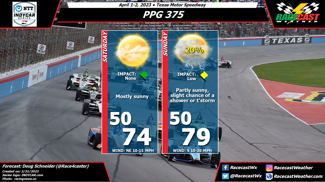
By Doug Schneider The main change to the forecast for the PPG 375 at Texas Motor Speedway is the addition of a small chance of showers or thunderstorms on Sunday afternoon. The main question with these showers will be if they will develop before or after the end of the race. The majority of the models indicate showers in the area right around the end of the race, which will be around 1:30 pm CDT. Past this time, the chance of rain increases. But there are some models that bring the showers into the area a little earlier. I think the chance of rain impacting the race is about 20%, while the chance of seeing rain after the race ends is about 50%. This is why I have impact as low - I think the most likely scenario is for the rain to arrive after the race ends. Let's hope that's the case.
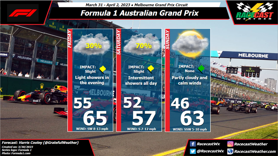
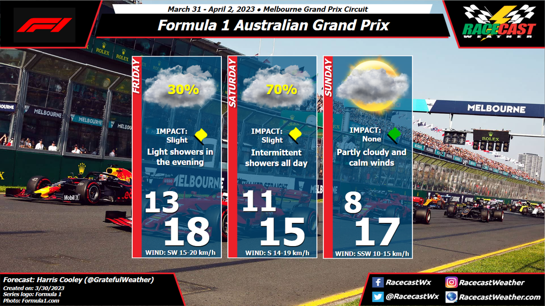
By: Harris Cooley Steady flow of moisture will be flowing into the region from the south bringing light showers Friday through Saturday. A light cold front will be passing that Saturday night into Sunday morning dropping temps and humidity a bit. Race day will be near perfect driving conditions and should allow the teams' to push their cars as their tires should hold up nicely. Cool track temps and low winds will be the theme for Sunday.
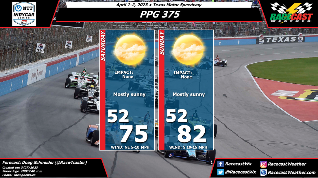
The practice sessions and quali could get slippery as steady rain will keep the track wet. Updates to the rain chances will come this weekend. A metric graphic is posted below... By Doug Schneider Perfect weather conditions are expected this weekend as the INDYCAR Series moves to Texas Motor Speedway. Showers will be in the area on Friday, but they will be long gone by the time on-track activity begins on Saturday morning. High pressure will be building over the area on Saturday, providing mostly sunny skies, pleasant temperatures, and low humidity. The high pressure center will track east, and this will shift winds around to the south on Sunday. Winds will also be a little stronger on Sunday, mainly between 10 and 15 mph with some higher gusts now and then. Temperatures will be warmer with the south wind, into the lower 80s during the race.
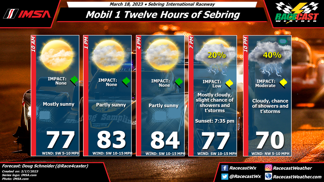
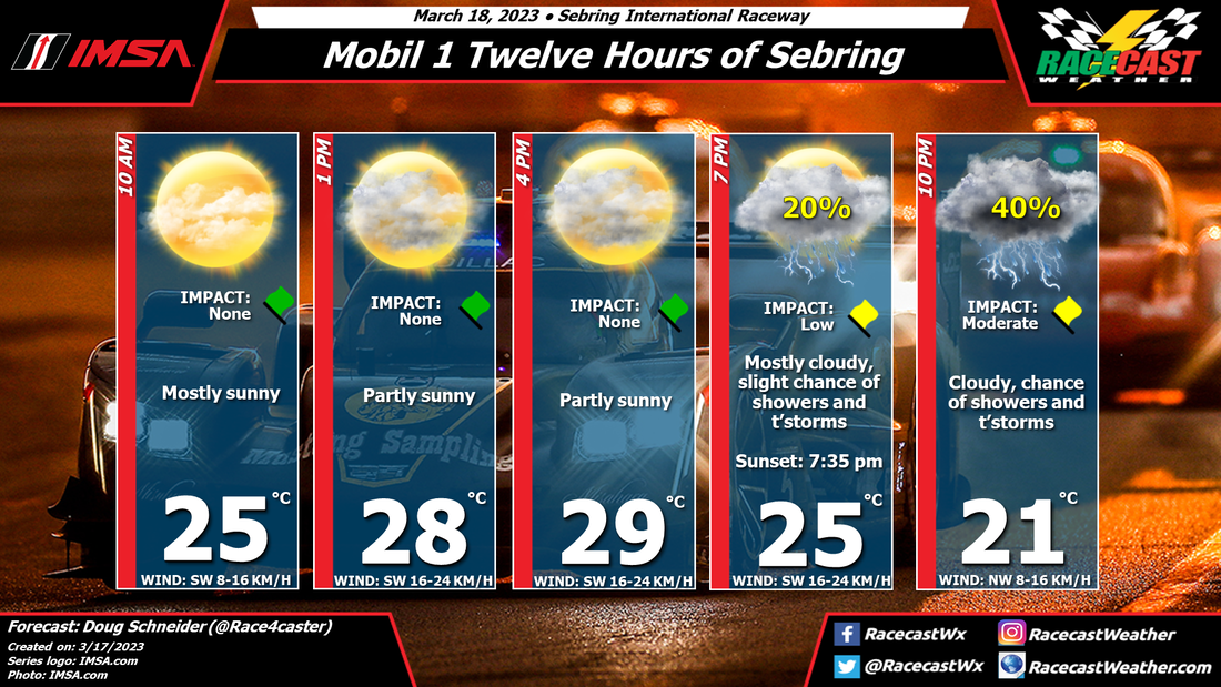
By Doug Schneider Click the forecast images to enlarge Good news with today's forecast update - the cold front that will be approaching Sebring is trending slower, which means a later arrival of showers. A later arrival time closer to sunset means there will be less instability for storms to tap into, so strong storms are unlikely. The coverage of showers is also looking less than it was before, so the chance of shower during the race is lowering.
There are still some timing differences among the models, but I expect that the window for showers and thunderstorms to arrive will be between 7 pm and 10 pm - the last few hours of the race. There is still a potential for a lightning delay, depending on whether a storm tracks close enough to the track, but the risk appears lower than with previous forecasts. The threat of strong wind gusts and heavy rain has also decreased, but again, the threat will depend on whether a storm moves directly over the track. With coverage expected to be scattered, they could miss the track completely. I'll try my best to post radar updates during the race on our Twitter account - @RacecastWx. By Doug Schneider Click on the forecast images to enlarge Not much has changed with the expected weather pattern at Sebring this weekend. Thursday and Friday continue to look great, with plenty of sunshine and warm temperatures each afternoon.
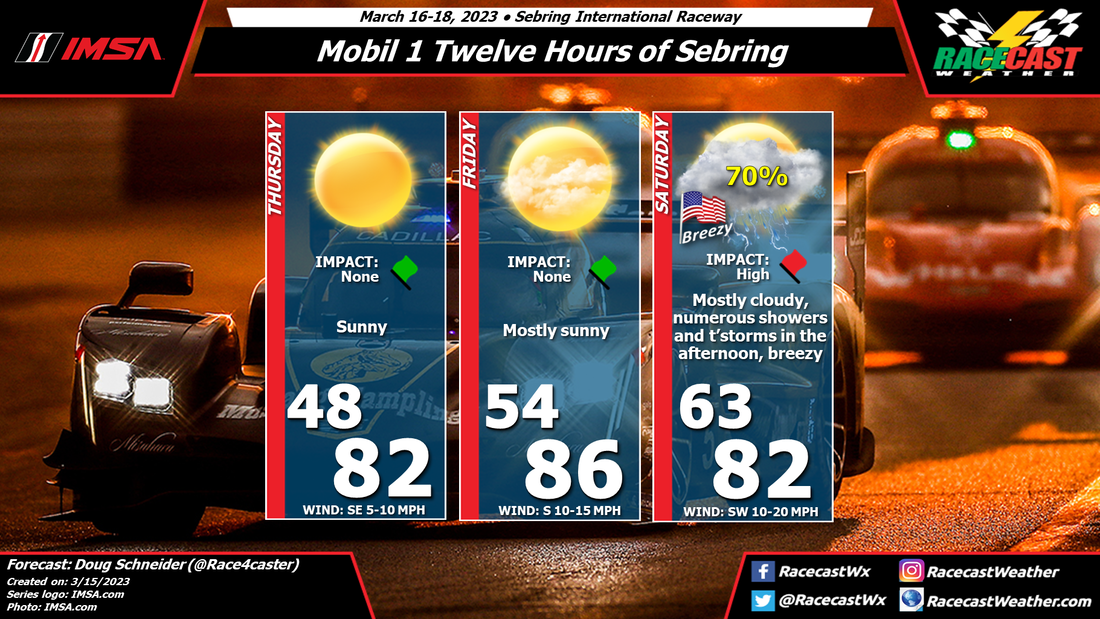
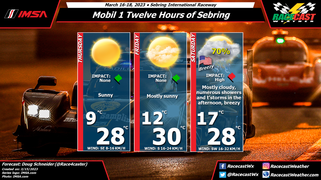
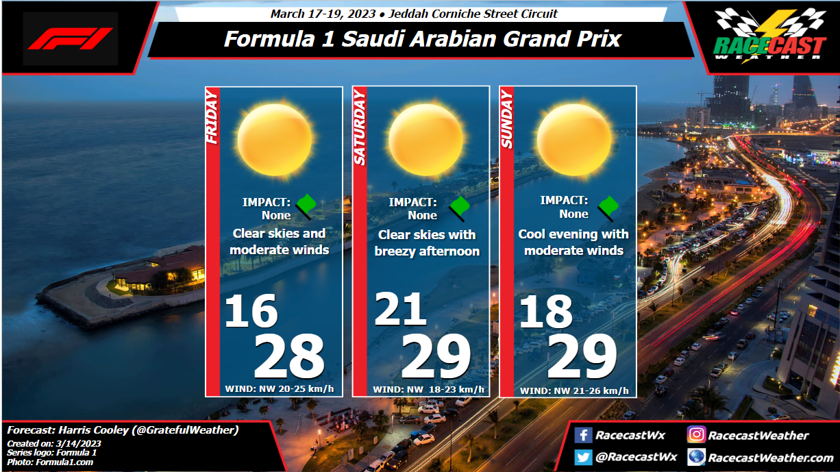
Saturday continues to be a concern for impactful weather at the track. A cold front approaching from the north will interact with a warm and unstable air mass across the Florida Peninsula, leading to showers and thunderstorms in the area during the afternoon. Timing continues to be very uncertain, as the arrival time of rain is different in the models by several hours. The earliest arrival time looks to be between noon and 2 pm. However, I think the most likely time for showers to begin at the track will be between 2 pm and 5 pm. There could be multiple rounds of showers, so I expect that rain and possibly some thunderstorms could remain around the area into the evening hours. The main impact with these storms will be lightning. It will be important for fans to have a place to seek shelter when thunder is heard. I expect that lightning will result in a stoppage of the race at some point for the safety of the corner marshals and the cameramen on towers. Another possible impact will be winds, which could become gusty when the storms move in, so campers will need to secure loose objects, especially tents and canopies. Finally, a brief heavy downpour will be possible. I expect the total rainfall amount through the end of the race to be between a quarter and a half inch, but it could come down quite heavily at times. By: Harris Cooley Conditions will be very similar to Bahrain with hot, sunny afternoons and cool evenings. Most of the driving will be done in the evening/night time which will mitigate the risk of high track temps. Higher wind speeds will be sustained in the evenings as a bit of a sea breeze will be present this weekend. This could bring about some traction issues as sand will be blowing onto the track. This has not been a major hindrance in the past but is definitely something to note. A metric graphic is posted below...
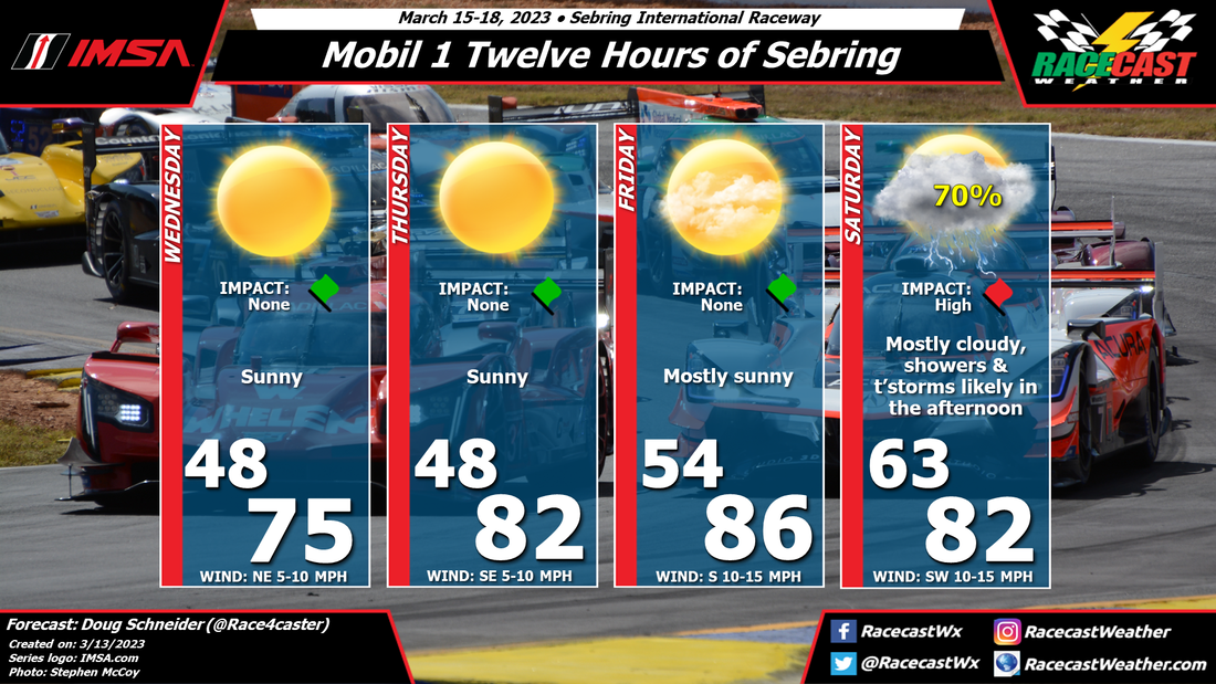
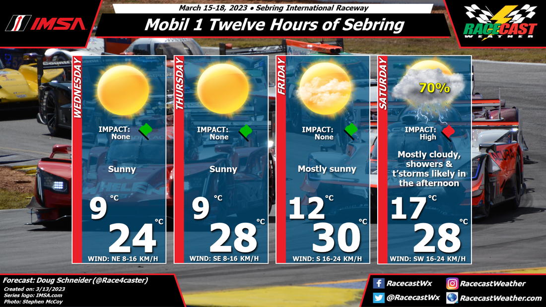
By Doug Schneider Click on the forecast images to enlarge All eyes will be on the Saturday's weather for this year's edition of the 12 Hours of Sebring. The forecast graphics tell the story about Wednesday through Friday - beautiful weather is expected those days, with no impacts, so I'll focus on Saturday.
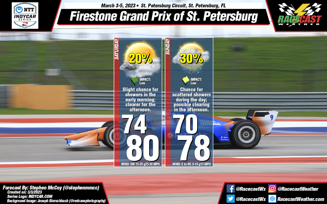
A cold front is expected to approach the area on Saturday, and cross Sebring late Saturday night. Rain is likely ahead of the front, in the form of numerous showers and thunderstorms. The primary hazard with these storms will be lightning. I expect that there will be delays during the race due to lightning in the area. Other potential impacts from storms will be heavy downpours and gusty winds. Fans at the track should be prepared for rainy and windy conditions, and have a plan to seek shelter when lightning is in the area. The uncertainty with these impacts is when they will happen. There will be a warm and unstable air mass ahead of the approaching cold front across southern and central Florida, so thunderstorms could pop up early in the afternoon. However, it looks like the models are showing the bulk of rain occurring in the late afternoon and evening hours, during the second half of the race. The thunderstorm threat will linger into Saturday night for campers at the track, as the front isn't expected to move through the area until late in the night or early Sunday morning. Since we are still several days away, the exact timing remains unclear, but that should come into better focus later in the week. Check back here for updates. By: Stephen McCoy With the previous forecast for St. Pete, the cold front affecting the region was expected to fully move through during the weekend, but timing was not yet clear. Now, the front is expected move through during the afternoon on Saturday. Saturday morning, ahead of the front, there is a slight chance for light, isolated showers as winds from the southwest bring in moisture to the area. Partly to mostly cloudy conditions are also expected Saturday morning, but will gradually clear for the afternoon before increasing overnight into Sunday. Winds won't be as strong as Friday, but will still be around 10-15 mph with gusts at 25-30.
As opposed to the previous forecast, the cold front is now expected to stall just to the south of the Tampa region, becoming stationary until Monday. Winds will shift to the north/northeast, much like what was expected, however cloudy conditions will persist for Sunday morning with more partly cloudy conditions possible for the afternoon. The stationary front will also maintain chances for scattered showers mainly overnight, but could extend into the day. Rainfall will be fairly light with totals only expected less than 1/10". |
Social Feeds
Authors
Doug Schneider Partners
Categories
All
Archives
December 2023
|

