|
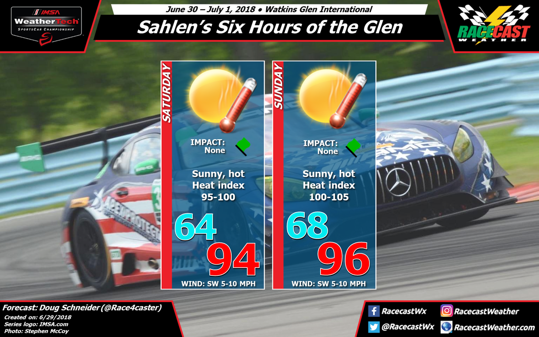
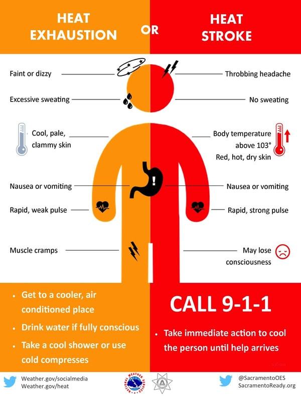
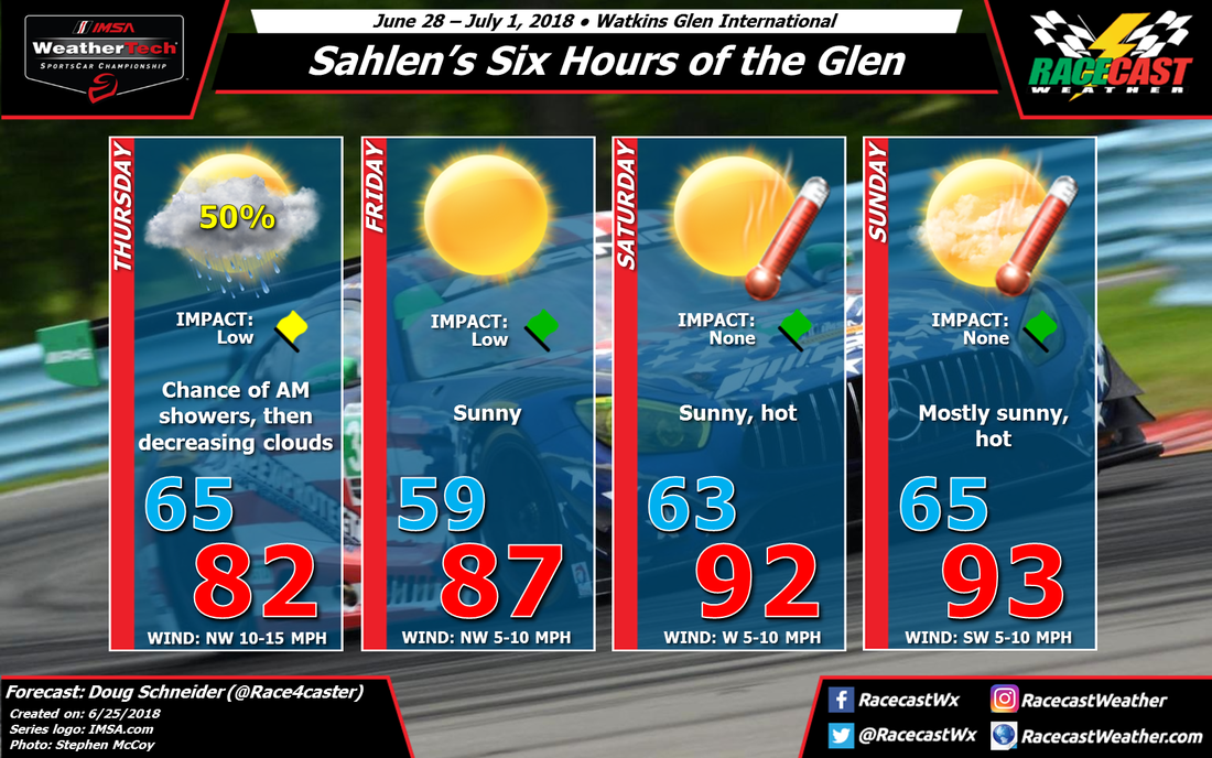
By Doug Schneider Hot temperatures continue to be the main weather feature at Watkins Glen this weekend. In fact, the National Weather Service in Binghamton has issued a Heat Advisory for both Saturday and Sunday. The heat and humidity will push the heat index between 95 and 100 on Saturday, and between 100 and 105 on Sunday. At these heat index levels, heat illnesses and heat stroke are possible if precautions are not taken. Drink plenty of fluids, stay in shade as much as possible, and wear light weight and loose fitting clothing. Be aware of the signs of heat exhaustion and heat stroke.
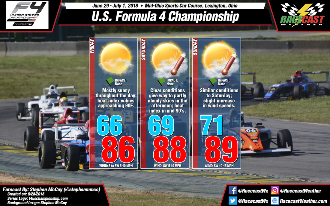
By: Stephen McCoy On Friday an upper level high pressure ridge will build in over the Midwest and Southeast states, slowly tracking eastward towards the Atlantic during the forecast period. Southerly winds in the low levels and at the surface will bring warm, moist air into the region, resulting in air temperatures in the upper 80’s and dew point temperatures in the upper 60’s. With high dew point temperatures, heat index values are likely to approach or exceed 90F. Mostly sunny conditions are expected as the high pressure ridge will suppress any chance of precipitation during the day.
Much of the same is expected for Saturday, although conditions look to be warmer than Friday. The upper level ridge will continue to move eastward, with the center passing over the region during the mid-afternoon. Winds from the southwest in the low levels and at the surface will continue to bring moisture into the area, raising dew point temperatures to the low 70’s. Heat index values will exceed 90F and are more likely to approach the mid 90’s. With more moisture present, expect partly cloudy conditions to dominate the day. On Sunday, winds in the upper levels will shift to the south as the high pressure ridge moves over the Atlantic, which will result in most of the cloud cover for the day being concentrated in the mid to upper levels. Otherwise, conditions will be much similar to Saturday, with temperatures in the upper 80’s and heat index values in the mid 90’s. By Doug Schneider The models have been quite consistent from one run to the next this week, so this gives me more confidence that this forecast is going to work out well. There were not many changes that were needed with today's forecast update.
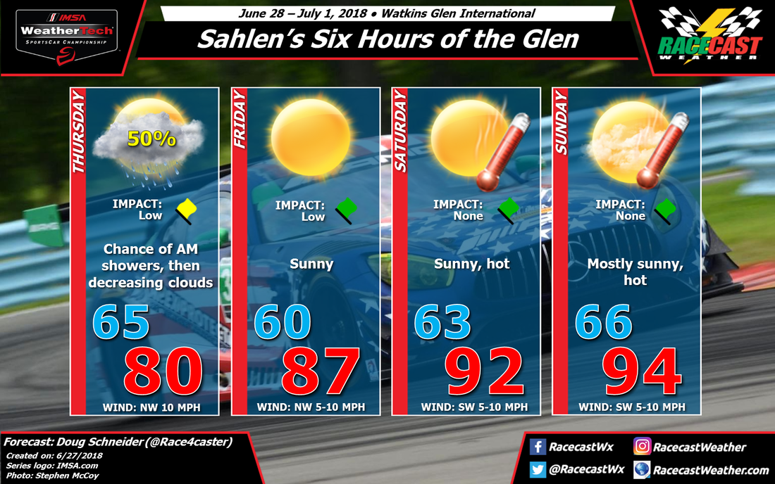
The pattern continues to be one that will produce a rain-free weekend, but hot temperatures. On Thursday, and front and upper level trough will cross the area, and the timing of showers with the front still looks to be mainly in the morning. Rain amounts Thursday morning could be in the range of a tenth to a quarter inch. Conditions will be improving through the day, with some partial clearing of clouds expected in the afternoon. As high pressure builds in from the west beginning on Friday, temperatures will be climbing each day, peaking in the mid 90s by Sunday. Humidity levels will also be increasing, and heat index values may approach 100 on Sunday afternoon. It will be important to take precautions to avoid heat stroke - take frequent breaks in the shade and drink plenty of water. Sunscreen will also be a necessity over the weekend. By Doug Schneider The weather pattern across the Northeast looks favorable for dry conditions for most of the racing action at Watkins Glen this weekend, but the temperatures will be abnormally hot.
A cold front and upper level trough is expected to move through upstate New York sometime late Wednesday night or early Thursday morning. By sunrise, the front should be to the east, but there will still be a chance of scattered showers around Watkins Glen. The chance of any impact on racing is low, but it could affect the Porsche GT3 Cup practice if it lingers a little longer. Clouds will be decreasing through the day as the upper trough moves away and drier air builds in on a northwest flow. A large high pressure ridge from the surface through the upper levels of the atmosphere will be building over New York for Friday and Saturday. The result will be sunny skies wand warming temperatures. Highs on Friday will be in the upper 80s, then reach the lower 90s on Saturday. The normal high temperature for this time of year is around 80 degrees, so it will be much warmer than normal. Sunday will continue to have hot temperatures, and humidity levels will be increasing. The increase in moisture may produce a little more cloud cover, but it will still be mostly sunny and hot, with highs well into the 90s. Some models hint at a chance of an afternoon shower developing, but I'm not confident enough in that happening yet to mention it in the forecast. I think the high pressure system will maintain stable conditions through Sunday. By Doug Schneider The chance of rain at Pikes Peak is climbing as we approach the weekend. The weather pattern that I described in my original forecast still looks on track, and with better model agreement and consistency, my confidence that there will be some showers and thunderstorms has increased.
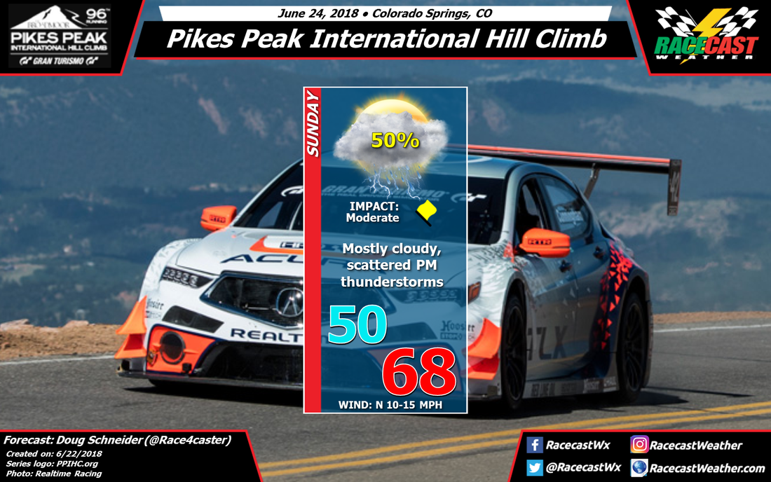
A mid to upper level low pressure area will be tracking across northern Utah and the Colorado/Wyoming border on Saturday night and Sunday. At the surface, a low pressure center will be taking shape in the Plains of eastern Colorado. These features will help draw some moisture northward and into the Front Range of the Rockies. The moist air rising up and over the mountains, combined with instability beneath the upper level trough, will lead to the development of afternoon showers and thunderstorms in the Colorado Springs and Pikes Peak area. The coverage of showers and thunderstorms will likely be scattered, so the chance of one affecting the hill climb is about 50%. If a storm does hit the track, it could cause some delays, and lightning will be a threat. The storms will be capable of dropping a good amount of rain in a short period of time, perhaps around a half inch. The best estimate for the timing window for storms is between noon and 4 pm local time. With the complex terrain of the Front Range, and the scattered coverage of storms, hopefully the storms can avoid the hill climb. But if you're heading to the event, it's best to be prepared for rain and lightning. Know where to find shelter when thunder is heard. By Scott Martin First of all I want to start off with an apology... I stated in my previous forecast that I would have radar up and running by Thursday morning for Road America and I failed to do that. There is a great reason for that happening... I had to use radar for my neck of the woods as we have had strong thunderstorms, and are forecast to have strong to severe on Friday. And since the forecast for Road America has "dried out," radar will be utilized for Alabama.
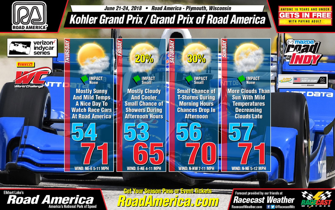
Now, like I said earlier, the forecast has dried out as all rain chances have been removed with the exception of early on Friday morning. This will be before cars will take to the track, but if it does happen, the track could be damp to start the day. Temperatures will be nice and mild and there will be more clouds than sun for much of the weekend. For those that are headed there this weekend, may I say that I am extremely jealous, as Road America is one of the track that I want to attend on my bucket list. Can someone help me get on as a series meteorologist, please! By Doug Schneider A few of our followers have asked for a forecast for the Pikes Peak hill climb this Sunday. This event seems to become more and more popular each year, so it may be something we add to our regular schedule in the future.
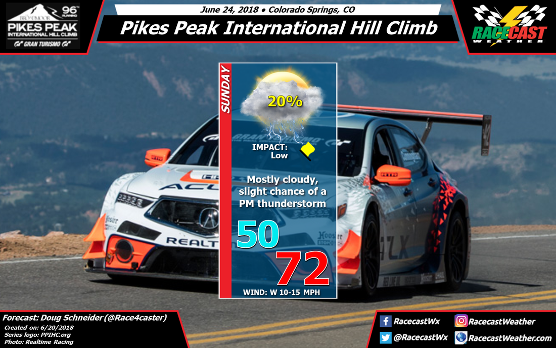
Forecasting for the complex terrain of the mountains can be very difficult and uncertain. Conditions can vary widely over a small area as air flows across the peaks and valleys, causing air to rise and sink, which impacts the temperature, moisture, and potential for rain. This forecast is for the start/finish line, which is located at an elevation of about 9,390 feet above sea level. The finish line is located at 14,115 feet, so the conditions there may be very different, particularly the temperature. Here's the general weather pattern that is expected this weekend - a low pressure trough in the mid and upper levels of the atmosphere is projected to be moving into the Utah/Colorado region. This will induce a low pressure center to form in southeastern Colorado, and the south to southeast flow across the Plains will draw some moisture into the mountains for Sunday. All these ingredients point toward mostly cloudy skies with a chance of showers and thunderstorms for Sunday afternoon. The finer details of what will happen at the course will probably not be clear until Sunday, but I'll have at least one more update to the forecast before then. By Scott Martin. Looks like the news is even better with this latest forecast update for the race weekend at Road America for the Verizon Indycar Series, the Pirelli World Challenge, all series of the Mazda Road To Indy, and the Battery Tender Global MX-5 Cup.
Thursday will feature the most sunshine of the event weekend, while there will be more clouds than sun from Friday through Sunday. There will be a small chance of rain starting during the afternoon hours on Friday afternoon, then increasing for the evening through the overnight hours. Saturday morning will start off with a small chance of showers and maybe a thunderstorm, but those chances will decrease some for the afternoon. Sunday will be a dry but mostly cloudy day to start, but will become partly cloudy by the late afternoon. Early morning lows will be in the 50s throughout the event weekend, with daytime highs topping out in the mid-60s to the lower 70s. I'll have radar for the event up and running on our site and on the Pirelli World Challenge website (world-challenge.com) by Thursday morning. |
Social Feeds
Authors
Doug Schneider Partners
Categories
All
Archives
December 2023
|

