Racecast Weather - Your Source for Race Weather Information
  • Home
  • Racecasts
  • 2023 Schedule
  • Services
  • Contact
  • Bios
  • Links

Forecast for the Bathurst 12 Hour

1/31/2016

Comments

 
By Doug Schneider (@Race4caster)
The Bathurst 12 Hour at the Mount Panorama Circuit has become one of my favorite races of the year. There's always great action, and Mount Panorama is an amazing circuit. Plus, forecasting for Australia is a big change for me, as everything is backward - winds around low pressure spin clockwise, and counter-clockwise around high pressure. South winds bring colder air, and north winds bring warmer air. It has taken me a few days of looking at weather maps of Australia to get my bearings. 

The general weather pattern for next weekend will be a large high pressure area off the southern coast of Australia, slowly drifting east. This is going to keep the weather dry for the Bathurst 12 Hour. There will be a fairly strong low pressure system off the east coast on Friday, and as high pressure builds in from the west, the pressure difference between these systems will bring breezy conditions on Friday, with a southeasterly wind bringing relatively cool temperatures in the mid 70s (mid 20s Celsius). Warmer temperatures closer to normal can be expected Saturday, with highs in the lower 80s (upper 20s Celsius). Normal high temperatures for Bathurst in February are in the lower 80s. The warming trend will continue into Sunday, with highs in the mid 80s. There may be a few more clouds around on Sunday, but no rain is expected.

Bathurst is 16 hours ahead of Eastern Standard Time (and 11 hours ahead of GMT in London). So for those of us in EST, the race starts at 1:45 pm Saturday, and ends at 1:45 am Sunday.
Comments

Race day weather: Rolex 24 Hours of Daytona

1/30/2016

Comments

 
By Doug Schneider (@Race4caster)
Picture
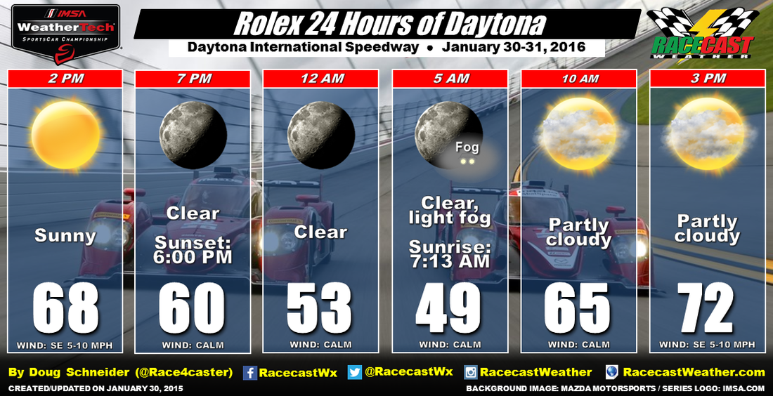
As we've been expecting for the past week, the weather looks great for the entire 24 Hours of Daytona. There will be plenty of sunshine today, so if you're at the track, use sunscreen. Temperatures will drop to around 50 degrees tonight, and there may be a little fog in the morning, but it doesn't look like a major issue at this point. Some clouds will be moving in on Sunday, but temperatures will be warming into the lower 70s by the end of the race.

Daytona International Speedway as their own weather sensor at the track, and you can see what the current conditions are at this link.
Comments

Thursday forecast update: Rolex 24 Hours of Daytona

1/28/2016

Comments

 
By Doug Schneider (@Race4caster)
Picture
Yesterday saw 2.31 inches of rain fall at the Daytona airport right beside the Speedway from 2 am through 1 pm. Fortunately, there was only some very light rain around through the afternoon (only a trace was recorded from 1 pm to 8 pm), and the Continental Tire practice sessions were relatively undisturbed. So while my forecast of 100% chance of rain verified, it was timed just right to have a minimal impact on the on-track activity. Temperatures yesterday stayed cool, with the high only reaching 65 degrees, due to a front that remained just south of Daytona all day (and ruining my temperature forecast). 

That front is sitting pretty much right over Daytona this morning. Most of the rain is well to the south early this morning, but that will change later this morning. A low pressure center will ride northeast along that front, and cross central Florida from late morning through mid afternoon. That appears to be the timing for the best rain chances and heaviest rain amounts at the track today. Some pockets of heavy rain and a few thunderstorms will be possible. The CTSC and IWSC practice sessions will be threatened, but that will depend on the timing of the heavier showers or storms. CTSC qualifying at 2:10 pm looks very wet as well. The amount of rainfall through the day is expected to be between 0.5 and 1 inch, but again, it will vary greatly based on where the heavier showers track. 

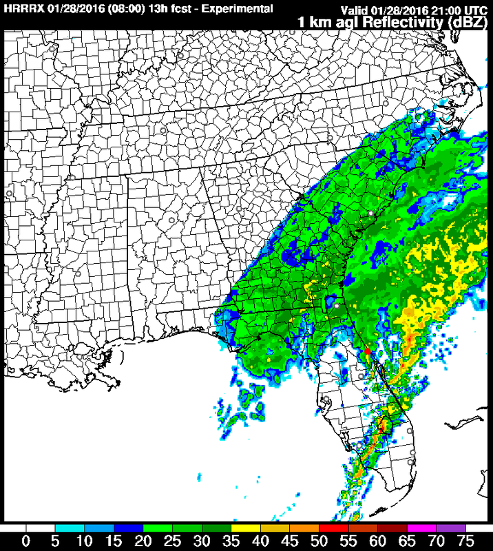
Will rain threaten the IWSC qualifying at 4:25 pm? It's going to be close. Here's a model simulated radar image at 4 pm this afternoon (Daytona is near the red dot):
Picture
I wouldn't take that model simulated radar as the absolute truth, but it does tell me that the rain will likely be tapering off around the time that qualifying begins, perhaps in a window between 3 pm and 5 pm. There are some other models that show similar timing to this one. Yesterday, I mentioned how one model (the NAM) was much slower to end the rain. Fortunately, it has straightened up and come into better agreement with the rest of the models.

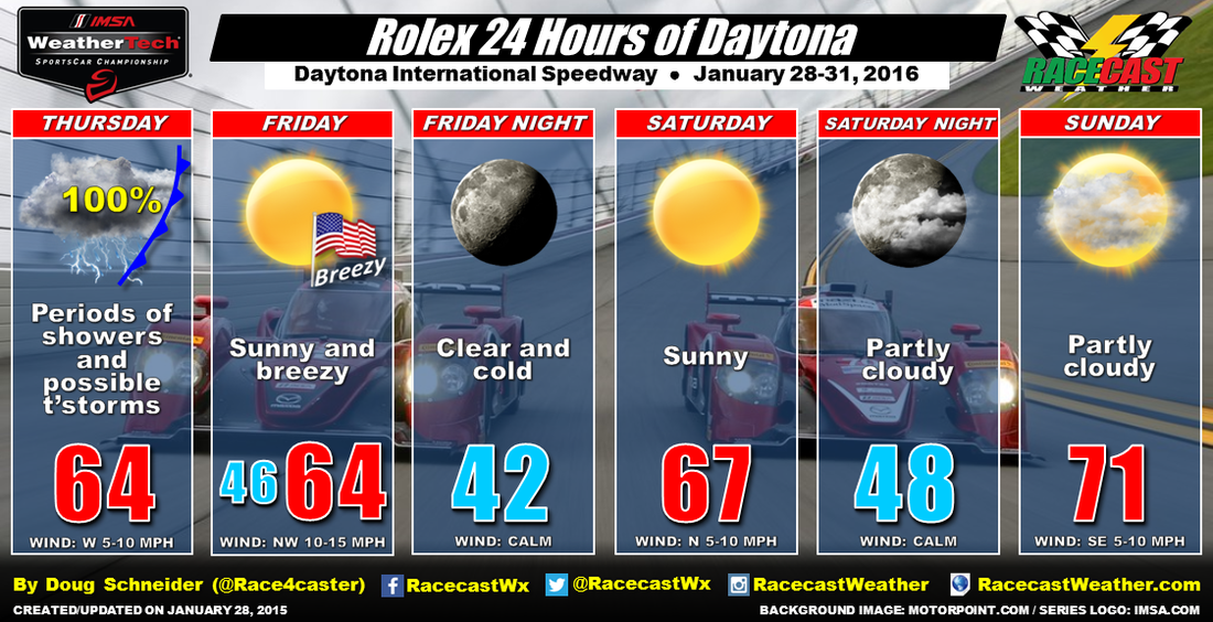
There are no big changes to the forecast for Friday, Saturday, and Sunday as the weather continues to look dry and cool. Bring a jacket on Friday, as it will be breezy with a northwest wind blowing 10 to 15 mph, and highs will be in the mid 60s. Race day will start off cold in the lower 40s, but with plenty of sunshine, highs will reach the upper 60s. The entire race continues to look dry, and by the end of the race, temperatures will be near 70 degrees.

Our live radar link at the top of the page will be continuously updating all day to help you keep track of the rain today. It will also display any lightning strikes that may occur. I'll most likely be watching qualifying along with the radar, and I'll do my best to have weather updates on Twitter this afternoon - follow @Race4caster.
Comments

Wednesday forecast update: Rolex 24 Hours of Daytona

1/27/2016

Comments

 
By Doug Schneider (@Race4caster)
Picture
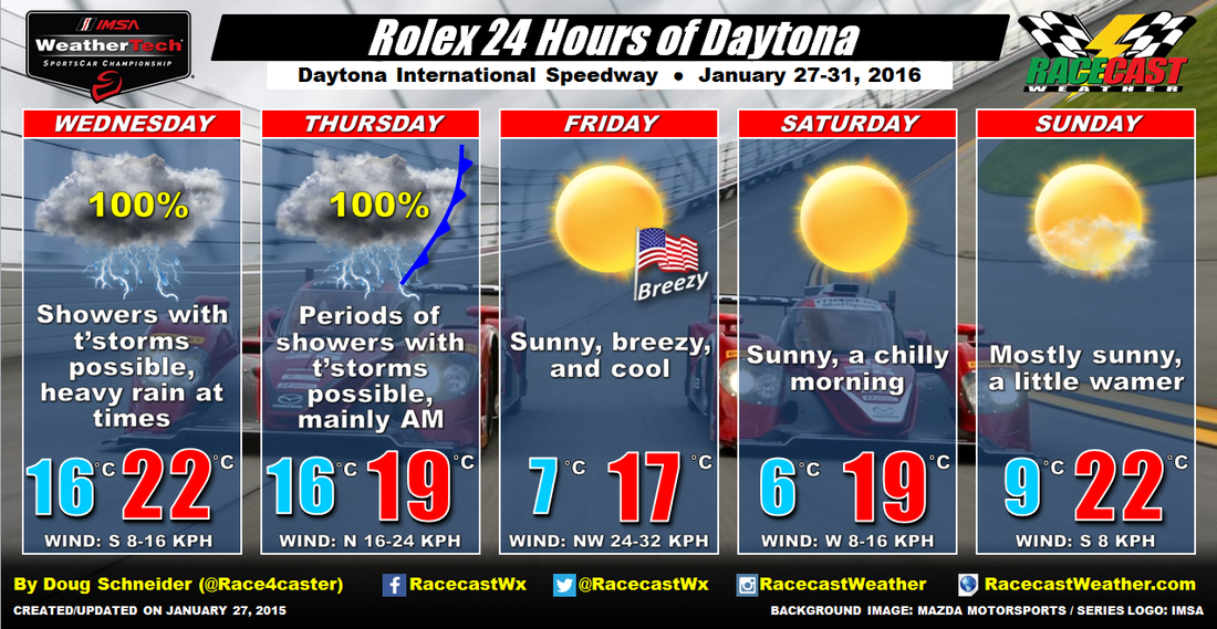
It's going to be a soggy opening day for the Rolex 24 Hours of Daytona. The radar this morning shows rain blanketing pretty much the entire Florida peninsula. A front is located from Tampa to Orlando to Daytona, which will remain nearly stationary in that location through the day. It will be the focus for showers and perhaps a few thunderstorms all day. Some of the showers will produce heavy rainfall, and the total rainfall amount through today and tonight is expected to be between 1.5 and 2 inches. The Storm Prediction Center is also calling for a marginal threat of severe thunderstorms today in central Florida. I don't expect this to be a problem, but it's something to be aware of if you're at the track today. Although the Ferrari Challenge and Continental Tire SportsCar Challenge are scheduled to practice today, I strongly doubt that there will be any on-track activity today. We'll have our live radar feed running today - follow the Radar link at the top of the website.

The low pressure center will track east across central Florida on Thursday, followed by a cold front. This will keep rain showers and possibly a few thunderstorms going through the day, although the rain amounts on Thursday will likely be less than Wednesday, probably around a quarter inch or so. But the question remains, when will the rain end? The majority of the models show a cold front moving through the Daytona area in the afternoon, and dry air builds in shortly after, ending any chance of rain in the evening. There is one model (the NAM) that is much slower with the cold front and drier air, keeping rain over Daytona until early Friday morning. I favor the faster model consensus, and I think the majority of the rain on Thursday will come in the morning, with decreasing rain chances through the afternoon, and any rain chance ending before midnight. This is what I've been forecasting since Sunday, and I'm going to stick with it. While there will be a chance of rain all day on Thursday, the afternoon qualifying sessions are more likely to take place than the morning practice sessions. 

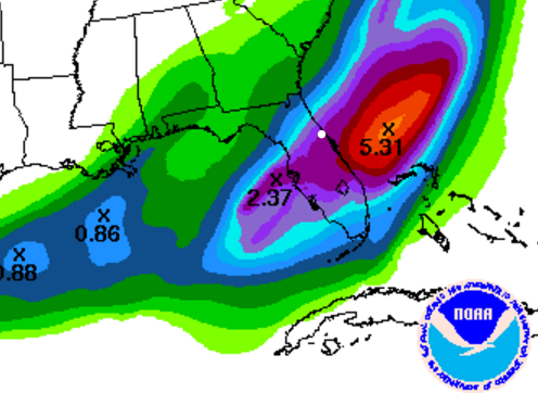
Here is the forecast rainfall amount map from the National Weather Service for Wednesday through Thursday night (again, the majority of this rain will fall on Wednesday). That's about 2 inches at Daytona (the white dot).
Picture
The weather for the rest of the event looks great, with plenty of sunshine each day. High pressure will move from west to east across the Gulf of Mexico and Florida peninsula Friday through Sunday. A northwest wind of 10-15 mph will keep temperatures rather chilly, with highs Friday in the lower 60s, and lows Saturday morning in the lower 40s. Temperatures will continue to trend upward for Saturday (upper 60s) and Sunday (lower 70s) as the high pressure center moves east of Florida. I don't think you could ask for better weather from start to finish for a 24 hour race (except perhaps for some warmer temperatures, if you like that sort of thing).

The forecast graphic in Celsius:
Picture
Comments

Video weather briefing for the Rolex 24 Hours of Daytona

1/25/2016

Comments

 
By Doug Schneider (@Race4caster)

A new feature this year for us will be video weather briefings for the big events. Here's the briefing for the Rolex 24:
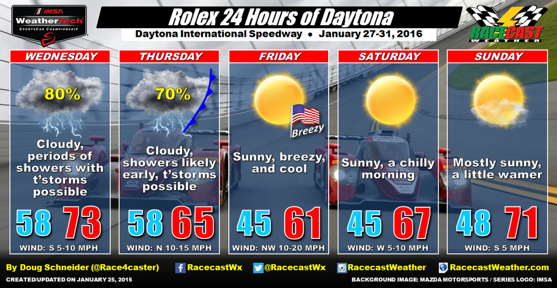
Here's the latest updated forecast graphic:
Picture
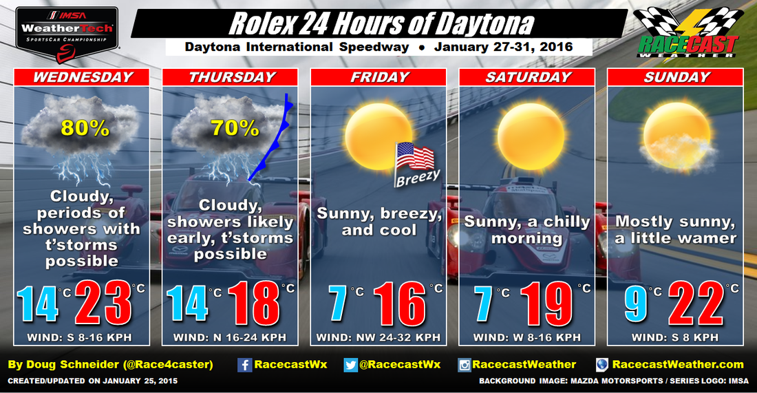
And the forecast in Celsius and kilometers per hour, for our international readers:
Picture
Comments

Forecast for the Rolex 24 Hours of Daytona

1/24/2016

Comments

 
By Doug Schneider (@Race4caster)
Picture
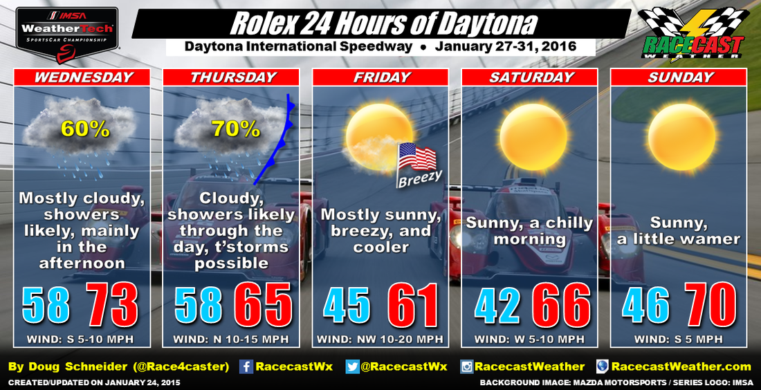
The seemingly long off-season is finally coming to a close, and the first big race of 2016 is less than a week away. So what will the weather do for the Rolex 24 Hours of Daytona? 

Florida will be under a wet pattern to start the event on Wednesday. A deep upper level trough will be dropping southward across the central United States toward the Gulf of Mexico. The south-to-southwest flow will provide plenty of moisture to the area ahead of the approaching trough, so rain showers are likely at the track on Wednesday. The rain may occur at any time of the day, but it appears that the bulk of it will be in the afternoon. Some of the showers could be heavy at times in the afternoon and evening. 

Rain showers are likely to continue into Wednesday night and Thursday as the surface low pressure center will be tracking east across central Florida. A few thunderstorms may be possible during this time, but that largely depends on the exact track of the low pressure center, which is still uncertain. A low that tracks farther north will mean a better chance of thunderstorms. The trailing cold front is expected to move through sometime Thursday evening, which will bring drier air and an end to the rain chances. 

Friday will be mostly sunny but cooler, with a brisk northwest wind. Winds will be between 10 and 20 mph, with gusts to around 25 mph at times. This will make for a pretty stiff cross-wind along the front stretch and back stretch. High temperatures will only top out in the lower 60s, which is about ten degrees below normal for this time of year in Daytona Beach. If you're heading to the race, be sure to pack some warm clothes and a coat, because temperatures will be quite chilly Saturday morning, with lows in the lower 40s.

​The weather for the race looks great from start to finish. High pressure will be drifting across the Florida peninsula, providing dry weather and clear skies Saturday and Sunday. Temperatures will be trending a little warmer for the race, with highs on Saturday in the mid 60s, and highs around 70 on Sunday. 

Be sure to follow all of our social media feeds - Twitter, Facebook, and Instagram - for forecast updates through the week. I'll also have a video weather briefing that I plan on posting here and on our YouTube channel tomorrow.
Comments

2015 forecast verification summary

1/20/2016

Comments

 
By Doug Schneider (@Race4caster)

An important part of forecasting is taking a look at what actually happened, and comparing that to what was forecast. By doing this, we can learn from our mistakes, and hopefully improve our forecasts. I also think it is important for our readers to understand the limitations of weather forecasting, and to be honest about how we're doing. So how accurate were our race forecasts in 2015? 

I looked back at our forecasts for 12 races from the 2015 season, and compared our forecasts to observations.

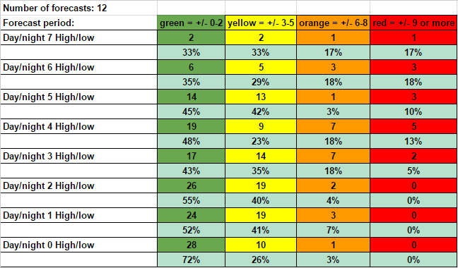
First, let's look at our temperature forecasts. The colored columns show how far off our forecast temperatures were from observations. These include both low and high temperatures. The numbers in the columns tell how many times our temperature forecast fell into those color ranges. The rows are forecast periods - how far in advance from a certain day the forecast is being made. So the Day/night 7 row represents forecasts that are made 7 days in advance. The Day/night 0 row is for forecasts that were posted on the same day as the observation.  The percent in each column shows what percent of forecasts for that period fell into each color range. So for all forecasts 4 days in advance, there were 19 times when our temperature forecast was within 2 degrees or less of the observed temperature, which is 48% of all Day 4 forecasts. 
Picture
As expected, the forecasts that were made 1, 2, or 3 days in advance were more accurate than forecasts made 4 days or more in advance. It is good to see that 87% of our forecasts made 5 days in advance were within 5 degrees of observation, and over 90% of our Day 0, 1, and 2 forecasts were within 5 degrees. Unfortunately, there were some big misses on temperatures (6 or more degrees off) on the 3 and 4 day forecasts.

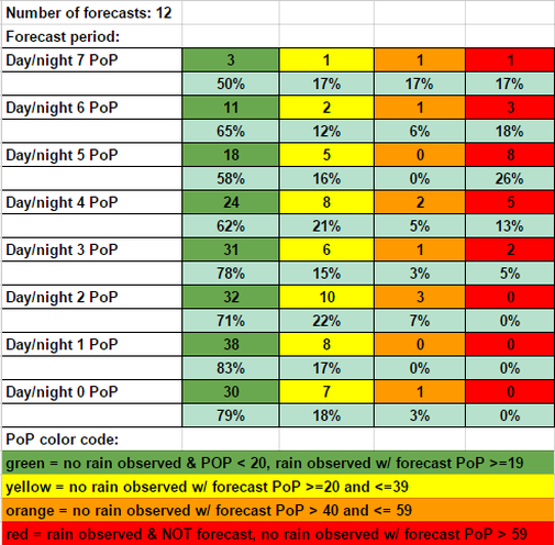
​Here's a look at our Probability of Precipitation (PoP) forecasts. For an explanation of what PoP means, see this post. A PoP forecast of less than 20% is considered a dry forecast. 

The PoP color code at the bottom explains what the colored columns mean. As was the case with temperatures, the longer-range forecasts were less accurate than the shorter-range forecasts. It appears that our precipitation forecasts jumped in accuracy once we reached 3 days out, with 78% of our forecasts being correct.
Picture
While most forecast were good, there's certainly room for improvement. Some race forecasts were definitely harder than others. Petit Le Mans stands out as one that was particularly difficult for me. 

​Some days are like this:
Picture
And other days are like this:
Picture
​Such is the life of a meteorologist.
Comments

Long term forecasting and the outlook for the Rolex 24

1/15/2016

Comments

 
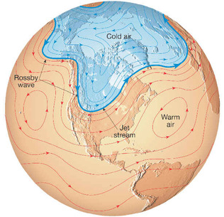
PictureWaves (called Rossby waves) consist of ridges and troughs in the middle and upper levels of the atmosphere that usually rotate counter-clockwise across the Northern Hemisphere. Image credit: stephenleahy.net
By Doug Schneider (@Race4caster)

I've already been seeing some forecasts for the Rolex 24 posted on social media. Some weather outlets have forecasts that go out over a month in advance - forecasting temperatures down to the degree, how much cloud cover there will be, and even whether rain will be light or heavy. I value my professional reputation too much to do such a thing. In my opinion, making a forecast that specific so far in advance is borderline irresponsible, and misrepresents the current limits of the science of meteorology. Depending on the weather pattern, computer models do not show a reasonable amount of predictive skill until 6 to 10 days in advance, and sometimes even less than that. As a general rule, I would not have any confidence in a specific weather forecast that goes beyond a week.

However, we can predict with some skill whether the weather pattern will favor temperatures or precipitation that are above or below climatology. Let me clarify a few things in that sentence. 

By "weather pattern", I mean the pattern of ridges and troughs that circulate around the Northern Hemisphere in the middle and upper levels of the atmosphere. Think of the atmosphere as waves in the ocean - there are ridges and troughs, and these waves rotate around the earth. The troughs bring cold air southward, and the ridges bring warm air northward. Some troughs are "deeper" (reach farther southward) than others. These waves usually circulate counter-clockwise around the Northern Hemisphere. There are several large-scale signals (El Nino being one of them) in the atmosphere and the ocean that influence the frequency, speed, and amplitude of these waves, allowing meteorologists to make predictions about how the wave pattern will change. The troughs and ridges influence the weather you feel at the ground by transporting masses of cold or warm air, and dry or moist air. They also generate areas of rising air or sinking air.

​By "climatology", I mean the weather than can typically be expected over a region of the globe at a certain time of the year, based on a 30-year average of temperature and precipitation (this average is also called "normal"). Based on climatology for Daytona Beach, Florida, a typical day in late January around the Rolex 24 weekend will have a high temperature of 69 degrees, a low temperature of 48 degrees, and about a 35% chance of rain. Here's a nice website that gives the climatology of Daytona Beach throughout the year.

If we can predict the pattern of waves across the Northern Hemisphere a few weeks in advance, then we can have some idea if the chances of rain are higher or lower than climatology, or if temperatures will be higher or lower than climatology. We can have a general idea of what might be expected for a region over a period of a few days in comparison to the 30-year average. However, we cannot skillfully predict what the temperature will be on a specific day in a specific location a month in advance.

The Climate Prediction Center is a branch of NOAA that issues these long term weather outlooks. They make weekly, monthly, and seasonal forecasts of how the weather will deviate from climatology. They predict if the temperature and precipitation is likely to be above or below normal, expressed as a "percent chance" that reflects their confidence. Sometimes the predicted wave pattern does not give a clear signal of whether temperatures or precipitation will be above or below normal. In this case, their forecast will be for "equal chances" of above or below normal.

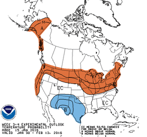
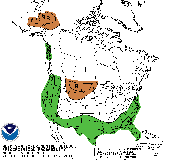
Here's their latest outlook that covers the Rolex 24 weekend:

Picture
CPC temperature probability outlook (click to enlarge)
Picture
CPC precipitation probability outlook (click to enlarge)
The image on the left of the probability of temperature above or below normal shows equal chances across Florida, so there's no strong signal that temperatures will either above or below normal. The most likely scenario is that temperatures will be fairly close to normal.

The image on the right shows that there is a 60% chance or greater that precipitation will be above normal.

​Keep in mind that this forecast covers a period of two weeks, and the Rolex 24 weekend is only two days out of the 14 days that it covers. So those two days could be completely dry, but the other 12 days have rain, and the forecast of above normal rainfall would still be accurate. 

That's the extent of what meteorologists can confidently tell about the weather this far out. If you see forecasts that tell you more detail than that two weeks away, take them with a grain of salt. 

I'll have the full Rolex 24 forecast up a week before the race, on January 24. 
Comments
<<Previous

    Social Feeds


    Instagram


    Authors

    Doug Schneider
    Scott Martin
    Stephen McCoy

    Harris Cooley 


    Partners

    Picture
    Picture
    Picture
    Picture
    Picture

    Categories

    All
    F1
    IGTC
    IMSA
    Indycar
    Le Mans
    MRTI
    NASA
    Outlooks
    Photos
    PWC
    Racecasts
    SCCA
    SRO
    Trans Am
    TUSC
    Verification
    Weather Education
    WEC


    Archives

    March 2023
    February 2023
    January 2023
    December 2022
    November 2022
    October 2022
    September 2022
    August 2022
    July 2022
    June 2022
    May 2022
    April 2022
    March 2022
    February 2022
    January 2022
    December 2021
    November 2021
    October 2021
    September 2021
    August 2021
    July 2021
    June 2021
    May 2021
    April 2021
    March 2021
    January 2021
    December 2020
    November 2020
    October 2020
    September 2020
    August 2020
    July 2020
    June 2020
    March 2020
    January 2020
    December 2019
    November 2019
    October 2019
    September 2019
    August 2019
    July 2019
    June 2019
    May 2019
    April 2019
    March 2019
    February 2019
    January 2019
    December 2018
    November 2018
    October 2018
    September 2018
    August 2018
    July 2018
    June 2018
    May 2018
    April 2018
    March 2018
    February 2018
    January 2018
    December 2017
    November 2017
    October 2017
    September 2017
    August 2017
    July 2017
    June 2017
    May 2017
    April 2017
    March 2017
    February 2017
    January 2017
    December 2016
    November 2016
    October 2016
    September 2016
    August 2016
    July 2016
    June 2016
    May 2016
    April 2016
    March 2016
    February 2016
    January 2016
    December 2015
    November 2015
    October 2015
    September 2015
    August 2015
    July 2015
    June 2015
    May 2015
    April 2015
    March 2015
    February 2015
    January 2015
    December 2014
    November 2014
    October 2014
    September 2014


Powered by Create your own unique website with customizable templates.