Racecast Weather - Your Source for Race Weather Information
  • Home
  • Racecasts
  • 2025 Schedule
  • Services
  • Contact
  • Bios
  • Links

The 25 Hours Of Thunderhill Forecast Update - WED AM

11/29/2017

Comments

 
By Scott Martin - ​@RaceWx4You
Picture
One thing that can either keep you very interested or make you very frustrated is a forecast that continuously changes. Fortunately, ever-changing weather keeps my job interesting. So far, looking over the model data coming in for this weekend at Thunderhill Raceway Park, conditions have improved from my Monday morning forecast to today's.

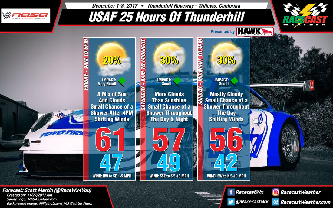
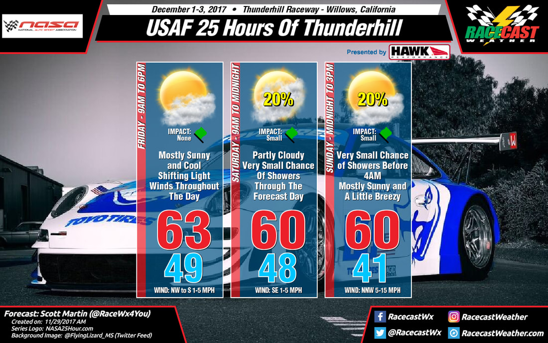
Friday looks to be a brilliant day out at the track with a good bit of sunshine throughout the day with only a few clouds. Temperatures will start off the track day around 49ºF at 9:00 AM, and will warm up to around 63ºF by the mid-afternoon hours. No rain is expected, and winds will be shifting from the northwest at the start to out of the south by qualifying time.

Models have come into better agreement with the system moving down into the area from the Gulf of Alaska on Saturday, keeping the better rain chances well north of the track. Unfortunately, there will be just enough moisture close by to merit a very small chance of showers during the entire racing day, when the best chances of rain activity occurring in the late evening hours on Saturday to the pre-dawn hours on Sunday. The temperatures will be around 48ºF at 9:00 AM then warming to around 53ºF at the drop of the green flag. The daytime high will be around 60ºF at the 3:00 PM hour and steadily dropping to near 50ºF at 8:00 PM.

Any rain activity should diminish before the 4:00 AM hour on Sunday morning and the skies will begin to clear somewhat. The morning low of around 41ºF will occur close to the 6:00 AM - 7:00 AM time period. Soon after, you will notice the winds begin to pick up in speed out of the north-northwest from 5 MPH up to 15 MPH by the late morning hours. At the checkered flag, the temperatures should be around 57ºF. The daytime high of around 60ºF will be reached during the post-race activities.

I'll have radar up and running starting on Friday morning on the website. Be sure to follow our main Twitter feed @RacecastWx as we will be using it as our one-stop place for forecasts and updates on Twitter. We'll continue to have our personal accounts as well, but we'll only use those to retweet our forecast and for personal use. As always, our forecasts will still be featured on our Facebook page along with our Instagram account. Thank you and have a great Wednesday.
Comments

To #SurviveThe25, We May Have To Deal With Some Rain

11/27/2017

Comments

 
By Scott Martin - ​@RaceWx4You
Picture
My first look forecast is out for the USAF 25 Hours of Thunderhill, and we have a little rainfall trying to sneak in. It's too early to give exact amounts and timing on the projected showers, but here is what we know at this point.

A system will be moving out of the Gulf of Alaska and will make its way into the area starting on Friday and will hang around throughout the weekend. Rain chances will start on Friday afternoon just before qualifying and will slightly increase throughout the overnight and pre-dawn hours on Saturday. Those chances will diminish a little throughout much of the day on Saturday before slightly rising for the late afternoon through the pre-dawn hours on Sunday morning. Unfortunately, a very small chance of a shower or two will remain throughout the end of the event on Sunday and afterwords for the awards ceremony.

For the graphic, the temperatures shown are the daytime highs on each day, with 9AM temperatures on Friday and Saturday, and the early morning low temperature on Sunday. When the event gets closer, I'll have a better breakdown with temperatures by the hour on raceday.

I'll have radar up and running starting on Friday morning on the website. Be sure to follow our main Twitter feed @RacecastWx as we will be using it as our one-stop place for forecasts and updates on Twitter. We'll continue to have our personal accounts as well, but we'll only use those to retweet our forecast and for personal use. As always, our forecasts will still be featured on our Facebook page along with our Instagram account. Thank you and have a great Monday.
Comments

Forecast for the Six Hours of Bahrain

11/13/2017

Comments

 
Doug Schneider - @Race4caster
Picture
Picture
Unsurprisingly, the forecast for Bahrain later this week has lots of sunshine and warm temperatures - just what you'd expect for an arid desert region. At the surface, high pressure will be centered over the western portion of Saudi Arabia on Thursday, then drift east to the Persian Gulf through Friday and Saturday. In the mid and upper levels, a ridge will be crossing the area. As this ridge moves to the east of Bahrain on Saturday, there may be an increase in high and midlevel clouds behind it, associated with an approaching jet stream and upper trough. But other than some increasing clouds on Saturday, each day will have very similar weather conditions to the day before it, with high temperatures in the mid 80s (upper 20s C) and lows around 70 (around 21 C). 
Comments

Friday Night Update For Trans Am At Daytona

11/10/2017

Comments

 
By Scott Martin - ​@RaceWx4You
Picture
Picture
Saturday's weather could be a little wet and definitely windy throughout the day. It will not rain all day as showers moving onshore from the Atlantic will be scattered in nature, but a brief heavy shower could be possible, especially during the late morning through the afternoon hours. The chance of the speedway getting rain will be around 40%. Skies will be mostly cloudy when it's not raining and afternoon highs will be in the lower 70s. Winds will be out of the northeast at 10-20 MPH with gusts up to 28 MPH possible. Rainfall amounts throughout the day should be less than 1/4 inch. Let's cross our fingers that the rain activity stays to the north.

Radar will be up and running on our site throughout the day, so feel free to take a look at any time. If you're using a smartphone to browse the radar, be sure to view as desktop site. Be sure to follow our main Twitter feed @RacecastWx as we will be using it as our one-stop place for forecasts and updates on Twitter. We'll continue to have our personal accounts as well, but we'll only use those to retweet our forecast and for personal use. As always, our forecasts will still be featured on our Facebook page along with our Instagram account. Thank you and have a great Friday night.

Comments

Forecast update for the 24H Series at COTA

11/10/2017

Comments

 
By Doug Schneider - @Race4caster
Picture
Picture
No big changes to the forecast for COTA and the 24H Series races this weekend as the expected weather pattern is still on track. Today has had a good amount of cloud cover that has kept temperatures in the lower to mid 60s. Tomorrow looks like it will be very similar, but it should get a little warmer as winds will be from the southeast instead of the east-northeast. A few breaks in the cloud may allow a little sunshine now and then, but most of the day will be cloudy. 

A cold front is still expected to approach the area from the northwest on Sunday. I think most of the shower activity with the front will remain to the west while the race is taking place, but I can't entirely rule out a shower reaching the track. I've left the Impact for the day at None because I think that even if there is a shower (which is only a 20% chance of happening at all), it will be very light and won't influence the race too much. Overall, it will be a nice weekend to get out and watch some awesome race cars.  
Comments

Thursday Night Update For Trans Am At Daytona

11/10/2017

Comments

 
By Scott Martin - ​@RaceWx4You
Picture
FRIDAY:  A small chance of showers will be possible during the early morning hours, but those shall be well before the cars hit the track. The day will feature more clouds than sun, and winds will be quite gusty at times, especially during the afternoon and early evening hours. Rain chances start to creep back into the forecast by the late evening hours, but the good news is that the main part of the day will be dry. Temperatures will be much cooler than the 82 degrees that was felt at the track on Thursday. Highs will only reach the lower 70s, and winds will be mainly out of the north and north-northeast at 7 to 16 MPH, with gusts up to 25 MPH possible. Grab those jackets and hang on to your hats.

SATURDAY:  Mostly cloudy skies and a chance of rain will be possible at Daytona International Speedway throughout the day on Saturday, as the main flow will be blowing onshore from the northeast. Winds will be even higher on Saturday as well, averaging 15-20 MPH, with gusts up to 25 MPH possible. Rainfall amounts will be light if it rains at the track, well less that a 1/4 inch, while the main heavier rain action will stay over the Atlantic well northeast of the track. Highs will be a little warmer, making it into the middle 70s, but those higher winds speeds will make that feel cooler.

I'm more confident in this forecast as the forecast model are coming into a better agreement, but some changes could occur. I'll let you know if they do. Be sure to follow our main Twitter feed @RacecastWx as we will be using it as our one-stop place for forecasts and updates on Twitter. We'll continue to have our personal accounts as well, but we'll only use those to retweet our forecast and for personal use. As always, our forecasts will still be featured on our Facebook page along with our Instagram account. Radar will be up and running on Friday. Thank you and have a great Thursday.
Comments

Forecast for the 24H Series at COTA

11/8/2017

Comments

 
By Doug Schneider
Picture
Picture
The Creventic 24H Series makes it first ever visit to the United States this weekend at COTA. If you're not familiar with the 24H Series, it features GT3, GT4, and Touring Cars. There will be one race on Saturday from 9 am to 11 pm CST and another on Sunday from 8 am to 6 pm CST. 

The weather is expected to cooperate for the majority of the event, and the slight chance of rain on Sunday is not expected to have much impact. By Thursday, a large high pressure system will be centered over the Great Lakes region, dominating the eastern half of the country. This will provide cool and dry conditions for COTA on Thurday and Friday. The high will shift east on Saturday, and the resulting shift of low level winds to the southeast will start to bring a little more moisture off the Gulf of Mexico. Saturday should have warmer temperatures and a little more cloud cover than Friday. 

An upper level trough will move into the Plains on Sunday, along with an associated cold front that will move across Texas. This is not a very strong trough or front, and there won't be a lot of moisture for it to work with, but it could produce a few isolated showers around central Texas on Sunday afternoon. I expect that if there are showers around, they will be light. As a result, I don't think that there should be much impact on the racing. 
Comments

Wednesday Forecast Update For Trans Am At Daytona

11/8/2017

Comments

 
By Scott Martin - ​@RaceWx4You
Picture
Wednesday will be a fine and dandy day down at "The World Center Of Racing" as a cold front will stay north of the track throughout the daytime hours. Skies will be mostly clear with just a few clouds floating overhead, while all of the rain activity stays well north into Georgia and Alabama. Afternoon high will be in the lower 80s, and winds will be shifting from out of the northwest to out of the northeast at 5-8 MPH. No rain for today.

By Thursday morning, the cold front has nearly moved through the entire state and will be well south of Daytona Beach. We'll have a few more clouds in the forecast with shifty winds, but it will be another day without rain (at this point). The afternoon high will be in the lower 80s once again, and winds will be out of the west to start, but shift out of the south by the afternoon. Any rain activity will form offshore, and that southerly wind will help with keeping them that way.
Picture
Friday, the track will be sandwiched between two cold fronts, as the one that passed through will be just south of  Florida, while another front will be approaching from the north. Pressure gradients will start tightening up a little, meaning that there will be an increase in wind speeds. Skies will continue to be mostly cloudy, and the temperatures will be around 8 degrees cooler than Thursday. The afternoon high will be in the lower 70s, and winds will be out of the north to northeast averaging 7-16 MPH, with gusts up to 20 MPH possible. Much of the day at this point looks to be dry, but a few showers may creep into the area by the very late afternoon and into the early evening hours.
Picture
Saturday will be the day that we will have to worry about rainfall at Daytona International Speedway. It will be a day that will be mostly cloudy, and rain could be possible at anytime. At this point, showers will be scattered in nature, but thunder and lightning should not be a threat. At some point, there could be enough rainfall for the rain tires to be warranted. One of the models is keeping the rainfall north of the area... but that is only one model out of many. At this point, timing, placement, and amount of rainfall is not set in stone, so I'm going with a risk of showers at any given time throughout the day, but it shouldn't rain all day long. The afternoon high will be in the mid-70s, and winds will be gusty at time, averaging 13-17 MPH and gusts to 25 MPH possible.

This will be an interesting forecast for race day, so be sure to follow our main Twitter feed @RacecastWx as we will be using it as our one-stop place for forecasts and updates on Twitter. We'll continue to have our personal accounts as well, but we'll only use those to retweet our forecast and for personal use. As always, our forecasts will still be featured on our Facebook page along with our Instagram account. Radar will be up and running on Friday. Thank you and have a great Wednesday.
Comments
<<Previous

    Social Feeds


    Instagram


    Authors

    Doug Schneider
    Stephen McCoy

    Harris Cooley 


    Categories

    All
    F1
    IGTC
    IMSA
    Indycar
    Le Mans
    MRTI
    NASA
    Outlooks
    Photos
    PWC
    Racecasts
    SCCA
    SRO
    Trans Am
    TUSC
    Verification
    Weather Education
    WEC


    Archives

    May 2025
    April 2025
    March 2025
    February 2025
    January 2025
    December 2024
    November 2024
    October 2024
    September 2024
    August 2024
    July 2024
    June 2024
    May 2024
    April 2024
    March 2024
    February 2024
    January 2024
    December 2023
    November 2023
    October 2023
    September 2023
    August 2023
    July 2023
    June 2023
    May 2023
    April 2023
    March 2023
    February 2023
    January 2023
    December 2022
    November 2022
    October 2022
    September 2022
    August 2022
    July 2022
    June 2022
    May 2022
    April 2022
    March 2022
    February 2022
    January 2022
    December 2021
    November 2021
    October 2021
    September 2021
    August 2021
    July 2021
    June 2021
    May 2021
    April 2021
    March 2021
    January 2021
    December 2020
    November 2020
    October 2020
    September 2020
    August 2020
    July 2020
    June 2020
    March 2020
    January 2020
    December 2019
    November 2019
    October 2019
    September 2019
    August 2019
    July 2019
    June 2019
    May 2019
    April 2019
    March 2019
    February 2019
    January 2019
    December 2018
    November 2018
    October 2018
    September 2018
    August 2018
    July 2018
    June 2018
    May 2018
    April 2018
    March 2018
    February 2018
    January 2018
    December 2017
    November 2017
    October 2017
    September 2017
    August 2017
    July 2017
    June 2017
    May 2017
    April 2017
    March 2017
    February 2017
    January 2017
    December 2016
    November 2016
    October 2016
    September 2016
    August 2016
    July 2016
    June 2016
    May 2016
    April 2016
    March 2016
    February 2016
    January 2016
    December 2015
    November 2015
    October 2015
    September 2015
    August 2015
    July 2015
    June 2015
    May 2015
    April 2015
    March 2015
    February 2015
    January 2015
    December 2014
    November 2014
    October 2014
    September 2014


Powered by Create your own unique website with customizable templates.