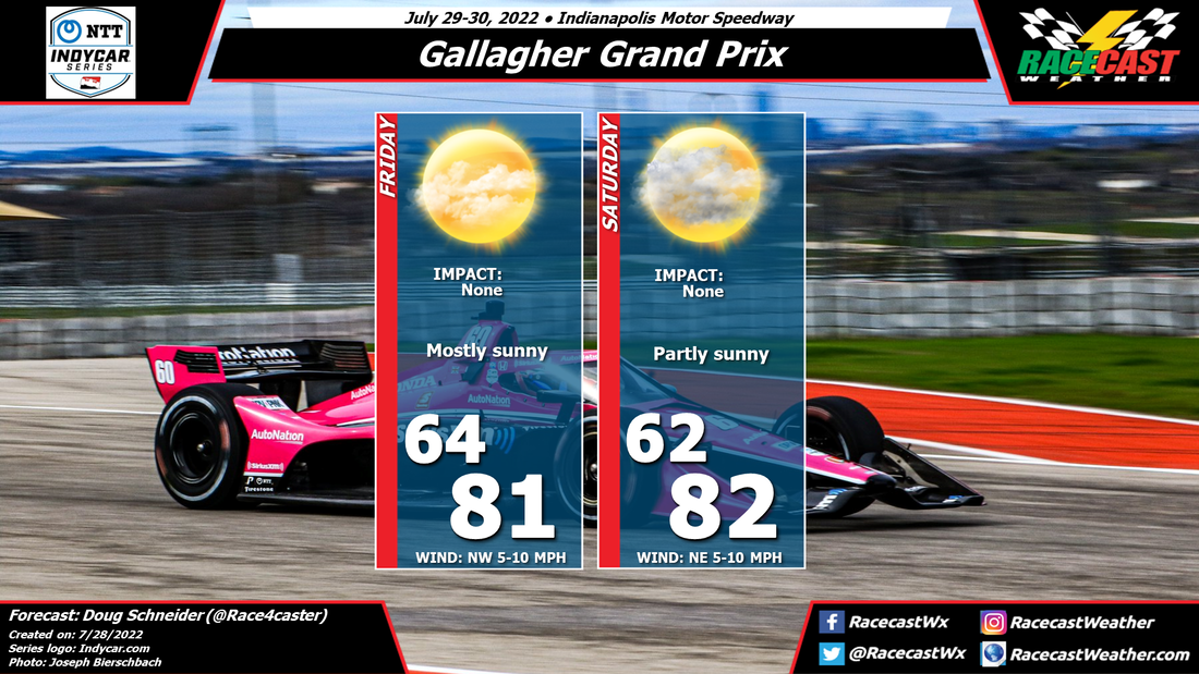
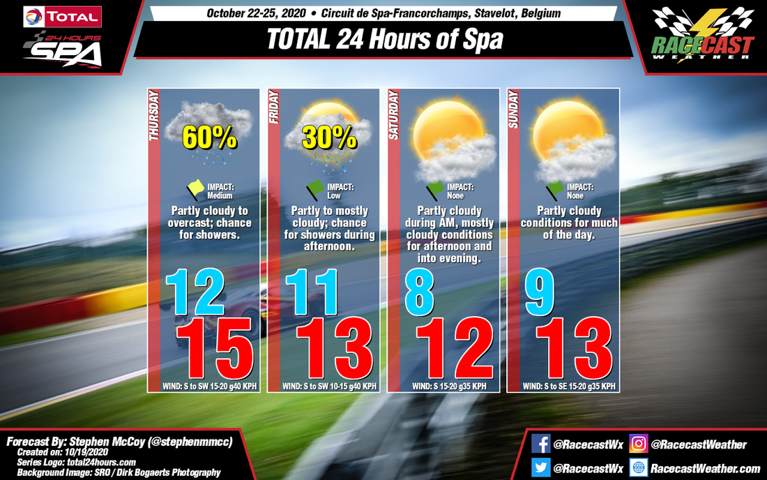
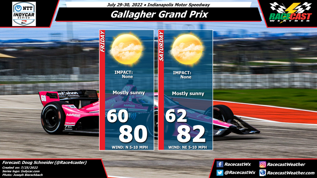
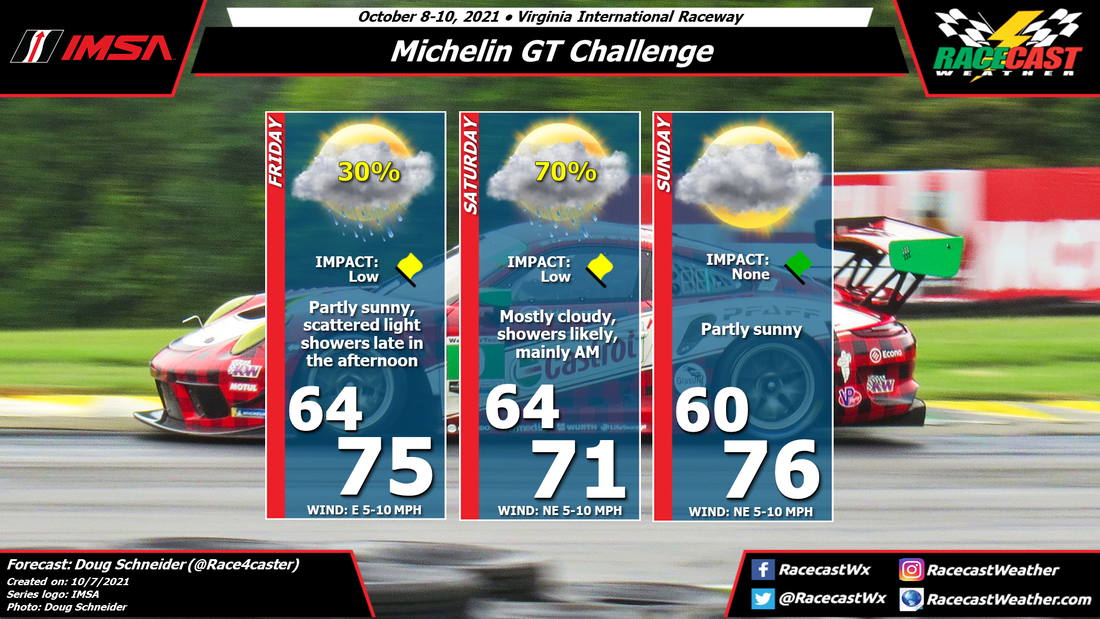
Racecast Weather - Your Source for Race Weather Information
  • Home
  • Racecasts
  • 2023 Schedule
  • Services
  • Contact
  • Bios
  • Links

First forecast for the IMSA Monterey Sports Car Championship

10/26/2020

Comments

 
By Doug Schneider
Picture
Beautiful California weather can be expected this weekend as IMSA heads to WeatherTech Raceway Laguna Seca. 

A large high pressure ridge will be over the west coast for the second half of this week. Through the weekend, this ridge will shift to the east, and a low pressure trough in the upper levels will approach from the west. The main affect of this will be temperatures that will trend warmer each day of the event, and a slight increase in high clouds on Sunday. 

Morning fog is often an issue at Laguna Seca, and while it can't be ruled out, it is too far out in the forecast to mention it as a problem at this time. Forecasting fog is difficult even a few hours in advance, so I'm not going to try to do it 4 to 6 days in advance. We'll see how that develops in later forecast updates.
Comments

Forecast update for the Firestone Grand Prix at St. Petersburg

10/21/2020

Comments

 
By Doug Schneider
Picture
Not much has changed in the weather pattern shown by the models for this weekend in St. Petersburg, so the forecast that I made on Monday still appears on track (no pun intended). A low pressure system will be over the Gulf of Mexico, with a high pressure system over the eastern United States. While I can't rule out an isolated shower or thunderstorm in the area both Saturday and Sunday, I don't expect that they are likely to have an impact on the racing. Pop-up showers along the Florida coast are difficult to predict days in advance, so while they are possible in the St. Pete area, their coverage should be isolated enough to make the chance of one occurring at the track very low. Overall, it should be a good weekend for racing. 
Comments

Forecast update for the TOTAL 24 Hours of Spa

10/21/2020

Comments

 
By: Stephen McCoy
Picture
Picture
Much like was stated in the initial forecast, a trailing front from a surface low pressure system centered over Scandinavia will sit mostly stationary over the region on Thursday and into Friday. South to southwesterly winds along the frontal boundary will bring a likely chance for precipitation during the day, with some of the heaviest rainfall occurring in the later hours, near qualifying and/or the night practice session. Low level winds from the south to southwest will cause mostly cloudy to overcast conditions through much of the weekend.

A cold front extending from a low pressure system north of the British Isles is expected to move through the region on Friday, bringing another chance for showers ahead of it around mid-day. The front will weaken as it passes through, however low temperatures for Saturday morning are still expected to cool from Friday's, though not as severely as initially thought.

The weekend will round out with another cold front approaching the region from the west. Winds continuing from the south to southwest ahead of the front will bring slight chances for isolated showers on both Saturday and Sunday, though with lighter rainfall than seen earlier in the weekend. However, the front itself will bring heavier rainfall as it passes through Sunday, which could impact conditions in the final hours of the race, depending on the timing of the passage.
Comments

Initial forecast for the TOTAL 24 Hours of Spa

10/19/2020

Comments

 
By: Stephen McCoy
Picture
Picture
It certainly won't be the conditions that the teams are typically used to for the 24 Hours of Spa. Temperatures for the weekend are looking to be in the upper 50's °F, or low teen's °C with chances for showers during the practice and qualifying days before somewhat clearer conditions move in for the race.

On Wednesday, a surface low pressure system is expected to move northeastward through mainland Europe, bringing warmer temperatures, strong winds and a likely chance for precipitation to the region. Entering Thursday, the system will be located over Scandinavia, with a front trailing behind to the southwest. The front is expected to sit mostly stationary over the region during the day, resulting in a chance for precipitation along the boundary. South to southwesterly winds will cause temperatures to be relatively consistent through the day, with a high only a few degrees warmer than the morning low. In addition, conditions will be mostly cloudy to overcast in the low levels through the day. The stationary front will move eastward out of the region overnight Friday, however a cold front from a low pressure system north of the British Isles will move into the region Friday afternoon, bringing a chance for scattered showers. South to southwesterly winds continuing overnight will keep temperatures relatively consistent with Thursday before the cold front passes and cools temperatures into Saturday.

After Friday's cold front passage, drier and slightly cooler conditions will move in for the 24 hour. Winds will shift towards the south to southeast for the race as another cold front begins a lengthy approach towards the region, passing through late Sunday or early Monday. Current model output is mixed on the passage time, though an earlier passage could mean heavier cloud cover for the race ahead of the front, with a later passage resulting in clearer conditions. An earlier frontal passage could also bring a slight chance for isolated showers, however for now there isn't enough to definitively say if rainfall will occur.
Comments

First forecast for the Firestone Grand Prix at St. Petersburg

10/19/2020

Comments

 
By Doug Schneider
Picture
The INDYCAR season finale at St. Peterburg is expected to have general good weather conditions, although an isolated shower or thunderstorm can't be ruled out.

The general weather pattern across Florida and the Gulf of Mexico later this week will feature a weak low pressure area over the Gulf that will be slowly tracking toward Florida. Over the weekend, it will be located just off the Florida coastline. It is a weak and poorly-defined low, which adds some uncertainty to the forecast. But it may be enough of a factor to produce some showers and thunderstorms near the St. Pete area, or maybe just offshore. This far out in the forecast, there is enough uncertainty about their location to warrant a small rain chance. However it doesn't look like they should have much impact if they do occur. 

​Check back through the week for forecast updates.
Comments

Forecast update for MOTUL Petit Le Mans

10/14/2020

Comments

 
By: Stephen McCoy
Picture
The general weather pattern of the weekend remains similar to the initial forecast from Monday. High pressure will be present over the region through Thursday before a cold front stretching through much of the east coast move through on Friday. High temperatures ahead of the front will be mostly near-normal in the low to mid 70's; behind the front, Saturday's high temperatures will be in the mid 60's.

Winds on Thursday will start from the east, but will shift towards the south as the day progresses, with mostly cloudy conditions expected in the mid levels during the morning to mid-afternoon, with partly cloudy skies for the later afternoon. A slight chance for isolated showers is possible around mid-day as the front begins its approach; rainfall would likely be in the form of light drizzle. Conditions for Friday will begin as mostly to fully clear before partly to mostly cloudy skies move in during the afternoon. Winds will largely be from the north to northwest during the day; a similar chance for precipitation to Thursday is expected.

The northwesterly winds on Friday will cool temperatures on Saturday to a low in the upper 40's. High pressure building in behind the front will cause winds to shift to the east to northeast, keeping temperatures relatively cool into the day. Zonal upper level flow will cause clear skies for the majority of the day, though some light cloud cover in the low levels may move in during the afternoon to evening.
Comments

First Forecast for MOTUL Petit Le Mans

10/12/2020

Comments

 
By: Stephen McCoy
Picture
Expect a warm start to the weekend for this weekend's MOTUL Petit Le Mans before a cold front passes through the region on Friday, which will bring a chance for showers ahead of it either Thursday afternoon or overnight into Friday morning. Cooler temperatures are anticipated after the front passes, with only a high in the low 60's for race day.

High pressure will move into the region on Tuesday, remaining present until Friday when a cold front approaches from the west. As a result of the high, and drier air aloft, clear conditions will be present for the day with light winds from the east to northeast. A temperature inversion is expected over the region Wednesday morning, and if dew point temperatures are warm enough, some patchy fog may be possible. Slightly cloudier conditions are anticipated for Thursday as the cold front begins moving through the southeast. Surface winds will once again be light, though from the east to southeast, but increasing and shifting towards the southwest overnight into Friday morning. There is a chance for scattered showers ahead of the front on Thursday, with another light round of isolated showers possible on Friday morning.

The possibility of overnight rain will also bring the possibility of fog Friday morning as the southerly winds ahead of the front cause the surface to become more saturated. After the front passes through, winds will increase from the northwest, with cloud cover gradually decreasing into the afternoon and evening. The cooler air behind the front will result in low temperatures for Saturday in the low 40's and warming to a high around 60 along with clear conditions for much of the day.
Comments

Friday forecast update for IMSA/NASCAR at the Charlotte Roval

10/9/2020

Comments

 
By Doug Schneider
Picture
The main change with the forecast for Charlotte today is on Sunday. The forecast track of Hurricane Delta hasn't changed much, but its forecast speed has slowed down. This will result in higher rain chances on Sunday, and higher potential for impacts on the NASCAR Cup race on Sunday afternoon. 

The first rain showers on the outer fringes of Delta may reach Charlotte on Saturday morning. These showers are expected to be fairly light, and should not pose too much of an issue for the morning IMSA practice session. Through the rest of the day and the evening, light showers will be possible, but the overall impact on the racing looks low. It may make for some interesting strategy decisions as the on/off rain may allow for the track to dry out between showers. Total rainfall amounts on Saturday are expected to be between a tenth and a quarter inch, but spread out over a 12-18 hour period. 

The chance of rain appears higher on Sunday as the remnants of Delta move across Tennessee. Bands of showers will sweep across Charlotte through the day, most likely in the afternoon. It is possible that some of these showers could be heavy, and delay the on-track action. While NASCAR does use rain tires on road courses, there may be times when the rain is too heavy to continue racing. Rain amounts of Sunday are expected to be between a quarter and a half inch. I don't expect thunderstorms to be an issue, and while winds will be in the 10-15 mph range, they should not be a big factor. 

I'll be at the Speedway on Saturday, so this is the last update I have planned.
Comments
<<Previous

    Social Feeds


    Instagram


    Authors

    Doug Schneider
    Scott Martin
    Stephen McCoy

    Harris Cooley 


    Partners

    Picture
    Picture
    Picture
    Picture
    Picture

    Categories

    All
    F1
    IGTC
    IMSA
    Indycar
    Le Mans
    MRTI
    NASA
    Outlooks
    Photos
    PWC
    Racecasts
    SCCA
    SRO
    Trans Am
    TUSC
    Verification
    Weather Education
    WEC


    Archives

    March 2023
    February 2023
    January 2023
    December 2022
    November 2022
    October 2022
    September 2022
    August 2022
    July 2022
    June 2022
    May 2022
    April 2022
    March 2022
    February 2022
    January 2022
    December 2021
    November 2021
    October 2021
    September 2021
    August 2021
    July 2021
    June 2021
    May 2021
    April 2021
    March 2021
    January 2021
    December 2020
    November 2020
    October 2020
    September 2020
    August 2020
    July 2020
    June 2020
    March 2020
    January 2020
    December 2019
    November 2019
    October 2019
    September 2019
    August 2019
    July 2019
    June 2019
    May 2019
    April 2019
    March 2019
    February 2019
    January 2019
    December 2018
    November 2018
    October 2018
    September 2018
    August 2018
    July 2018
    June 2018
    May 2018
    April 2018
    March 2018
    February 2018
    January 2018
    December 2017
    November 2017
    October 2017
    September 2017
    August 2017
    July 2017
    June 2017
    May 2017
    April 2017
    March 2017
    February 2017
    January 2017
    December 2016
    November 2016
    October 2016
    September 2016
    August 2016
    July 2016
    June 2016
    May 2016
    April 2016
    March 2016
    February 2016
    January 2016
    December 2015
    November 2015
    October 2015
    September 2015
    August 2015
    July 2015
    June 2015
    May 2015
    April 2015
    March 2015
    February 2015
    January 2015
    December 2014
    November 2014
    October 2014
    September 2014


Powered by Create your own unique website with customizable templates.