Racecast Weather - Your Source for Race Weather Information
  • Home
  • Racecasts
  • 2025 Schedule
  • Services
  • Contact
  • Bios
  • Links

Wednesday forecast update for the Harvest GP and Indianapolis 8 Hour

9/30/2020

Comments

 
By: Stephen McCoy
Picture
Picture
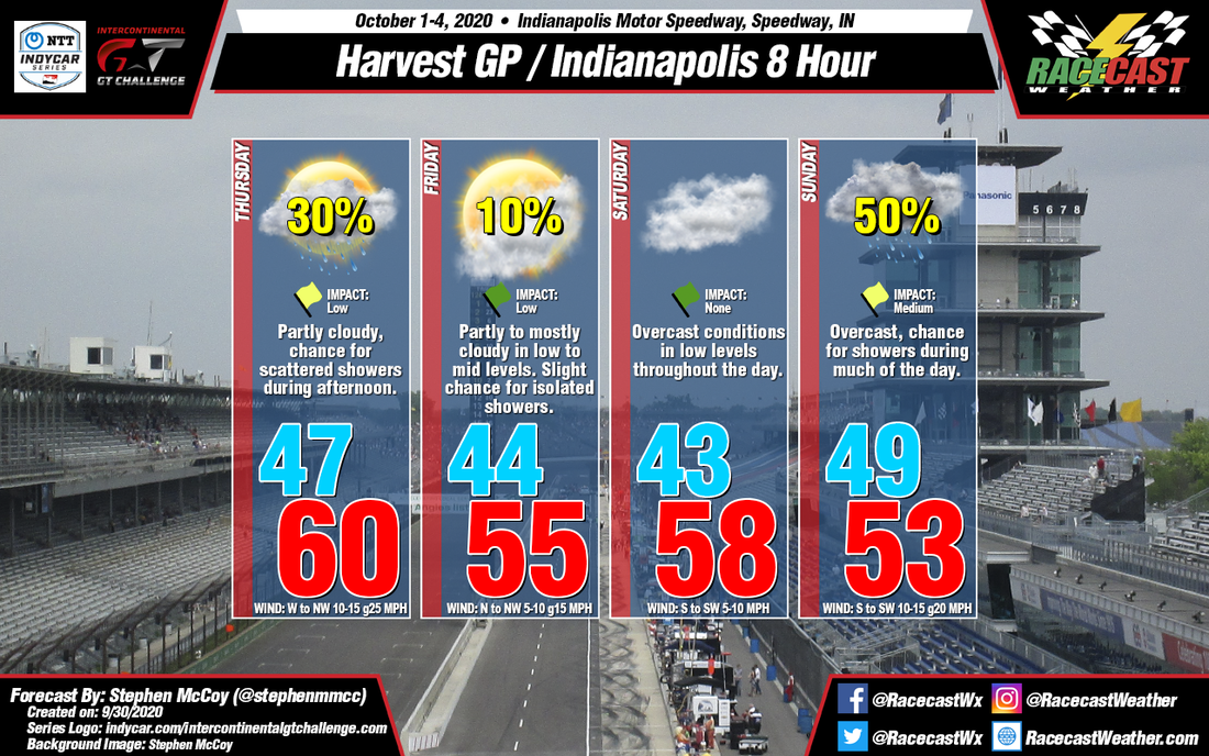
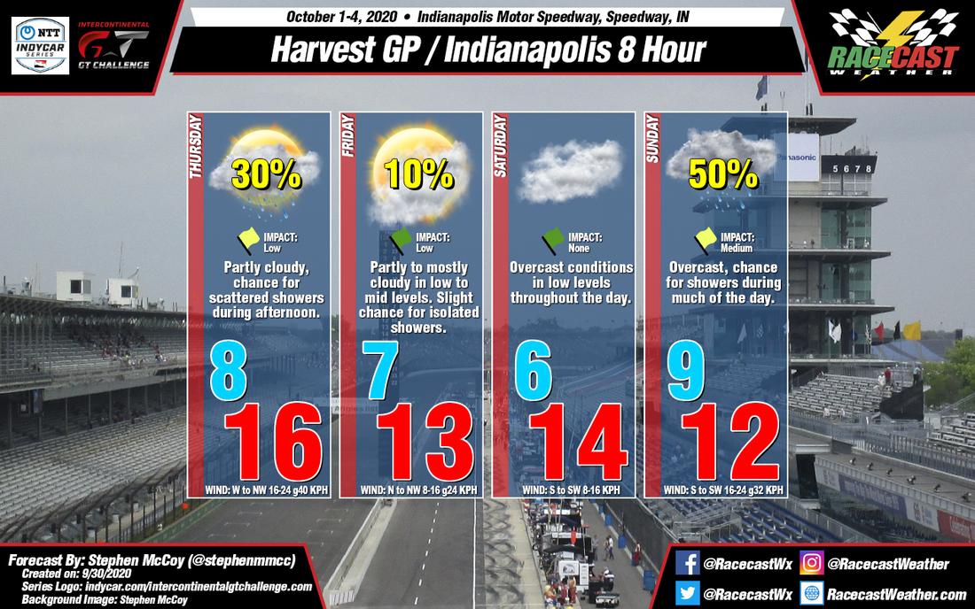
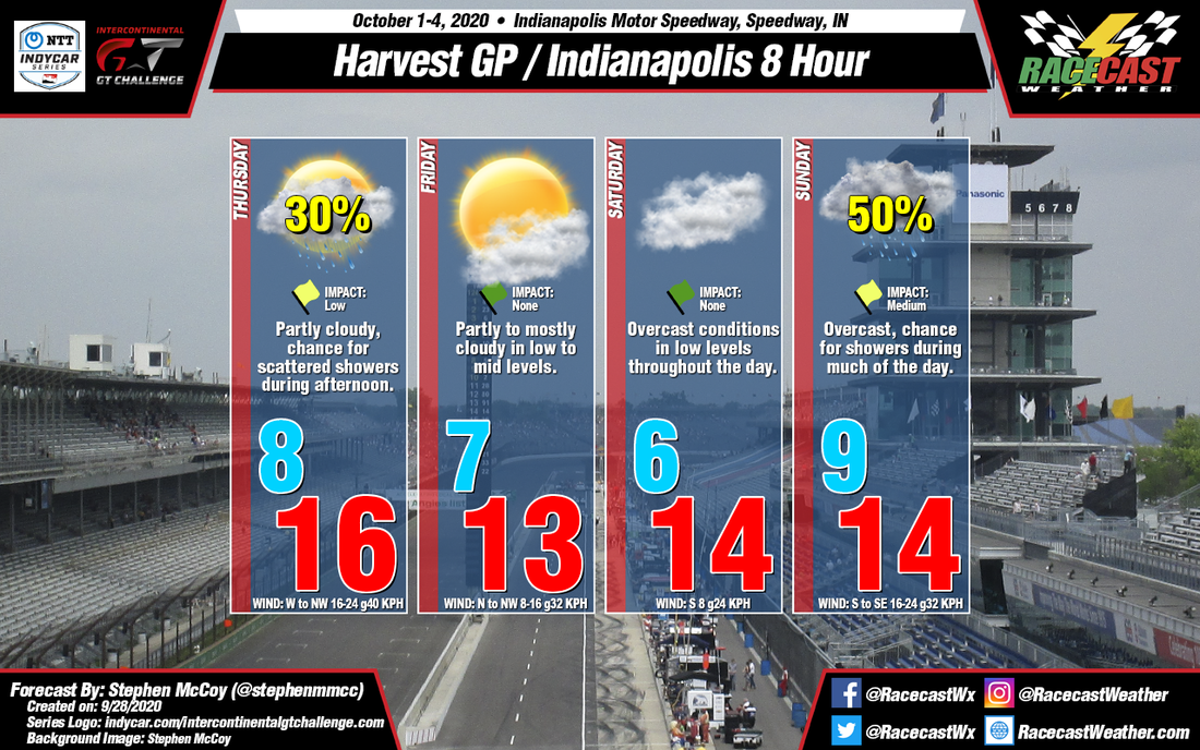
There have been a few changes to the temperatures for the weekend, but overall the forecast for Indianapolis Motor Speedway is still fairly consistent to the initial forecast from Monday. There is a slight chance for isolated showers on Friday, however rainfall rate for the day is expected in the hundredths of an inch, if any occurs.

The synoptic setup for the rest of the forecast period remains the same: a cold front passed through today, which will bring west to northwesterly winds to the region for tomorrow, resulting in cooler overall temperatures. A low pressure surface trough will approach central Indiana on Thursday from the north, bringing a chance for scattered showers in the afternoon. Rainfall totals are expected under a tenth of an inch, but still could disrupt some of the scheduled on track sessions. Behind the trough, high pressure will build in, causing surface winds largely from the north to northwest, continuing to cool temperatures with a morning low in the mid 40's °F and a high in the mid 50's °F.

The area of high pressure is anticipated to move over or close to the Indianapolis region, resulting in calm and variable winds during Saturday morning, with winds then shifting to the south to southwest in the afternoon as the system continues eastward. Saturday night, a warm front extending from a low pressure system to the west will pass through the area, causing Sunday's low temperatures to remain relatively unchanged from the previous day's high. Southwesterly winds behind the warm front and ahead of the pairing cold front will allow temperatures to warm a few degrees before cooling again as the cold front passes through. Both mentioned fronts could bring a chance for precipitation on Sunday, especially in the morning, however rainfall totals will be largely determined by the location of the surface low's center.
Comments

Forecast for the Harvest GP and Indianapolis 8 Hour

9/28/2020

Comments

 
By: Stephen McCoy
Picture
Picture
Cool, early-fall conditions are expected for this weekend's races at Indianapolis Motor Speedway, with chances for precipitation present at the beginning and end of the forecast period.

On Wednesday, a surface low pressure system will pass north of the Great Lakes as it tracks eastward towards the Atlantic Ocean. A trailing cold front will move through Indiana during this time period, setting up cooler temperatures for the region in the following days. West to northwesterly winds overnight Wednesday and into Thursday will result in morning low temperatures in the upper 40's °F and a high in the low 60's °F as the winds continue through the day. Behind the front, there is the possibility of a surface trough extending westward through the Great Lakes region from the aforementioned surface low and moving southward into Indiana during the day. The movement of the trough could bring a chance for scattered showers to the Indianapolis region, especially during the afternoon and may impact the various on-track sessions during this time.

As the surface low continues towards the east coast, high pressure is expected to slowly build into the region over the first part of the weekend. With the center of the surface high to the west, winds on Friday will be largely from the north to northwest, accompanied by partly to mostly cloudy conditions in the low to mid levels for much of the day. The cooler temperatures will continue with a low similar to Thursday and a high in the mid 50's °F. The surface high is anticipated to move over the central Midwest Friday night into Saturday, resulting in calm and variable winds for most of the early part of the day before shifting to the south as the high moves eastward. The lack of wind movement will extend to the low levels of the atmosphere, causing mostly cloudy to overcast conditions; temperatures will be similar to Friday.

Leading up to Sunday, an upper level shortwave trough will allow a low pressure system to develop at the surface over the northern Plains late Friday evening. Due to the trough's orientation, the surface low is expected to track southeastward, centering itself over Illinois on Sunday. Current model output disputes the exact location of the low, but general consensus indicates the center of the system will be either to the west or southwest of Indiana. As a result, a warm front will likely extend from the low somewhere over central Indiana; model output shows a disparity in the low temperature for Sunday as a result of the front, with a range of 10 °F in the most recent runs. In any case, the system is expected to bring a chance for precipitation and overcast skies through much of the day.
Comments

Friday forecast update for the 24 Hours of Le Mans

9/18/2020

Comments

 
By Doug Schneider
Picture
Rain showers will start to spread into the Le Mans area beginning tonight. Periods of showers are likely to continue through Saturday as a low pressure system sits over the Bay of Biscay. The most likely period for showers on Saturday will be in the afternoon and evening, during the opening hours of the race. There could be around a quarter of an inch (around 6 mm) of rain that falls on Saturday. 

Saturday night should have a lower chance of showers in the area. Coverage will be more scattered, and showers will be lighter. The threat of thunderstorms will also diminish. Scattered showers will continue around northern France through Sunday, and there may be some breaks in the clouds that allow some sun to briefly shine through. 

I will be travelling on vacation with family tomorrow, so I won't be able to post radar updates as I usually do. I recommend this site to monitor radar - https://www.meteo60.fr/radars-precipitations-pluie-france.php
Picture
Comments

Forecast update for World Challenge at COTA

9/17/2020

Comments

 
By Doug Schneider
Picture
Quite a bit of rain has fallen today at COTA, with just over a half inch of rain recorded at the Austin airport a few miles northwest of the track as of 4 pm CDT. The good news is that the rest of the event should be rain-free, with comfortable temperatures and plenty of sunshine.

The upper level low pressure system that brought rain to the area today will be tracking to the east, pushing rain off the Texas coast on Friday. With dry air expected to build in through the day, clouds will be decreasing from mostly cloudy in the morning to mostly sunny in the afternoon. 

The weekend weather continues to look great, with sunny skies Saturday and Sunday, with a northeast wind providing comfortable temperatures and humidity levels.

​There is one thing to note that I don't think will impact the racing, but could be a factor for Sunday night and Monday - A tropical system is expected to develop off the Texas coast over the weekend, and may start to drift to the west late Sunday. Rain may begin to spread back into COTA on Sunday night, but well after the racing has been completed.
Comments

Forecast update for the 24 Hours of Le Mans

9/16/2020

Comments

 
By Doug Schneider
Picture
Not much has changed in the forecast for Le Mans with the latest data. Some things have come into better focus, such as the timing of the best chance of rain and potential rainfall amounts. 

High pressure over the British Isles will keep conditions dry and mild at Le Mans on Thursday, with mostly sunny skies. Clouds will start to increase a little on Friday as the high pressure system moves east and a low pressure system off the northwest coast of Spain approaches. As this low moves into the Bay of Biscay, it will start to bring a chance of rain into northern France, beginning Friday night. There is good agreement between the models that the center of the low will be just off the west coast of France on Saturday, sitting nearly stationary through the day. Shower and thunderstorms will be numerous across eastern and northern France all day, but the most likely time for showers to occur at the track will be in the late afternoon and evening - near the start time of the race. The rain could be briefly heavy if a storm moves directly over the track, with a quarter to a half inch of rain possible (6-12 mm). There could be a possibility of a caution period or a stoppage if the heavy rain and lightning occurs. 

The threat of showers will drop Saturday night, but it won't completely go away. There may be some scattered showers lingering around overnight and into Sunday morning. The chance of rain on Sunday looks lower than Saturday as the low pressure system is expected to weaken and drift southeast. Any showers on Sunday should be lighter as well, so the impact on the racing is expected to be less. 
Picture
Comments

First forecast for World Challenge at COTA

9/15/2020

Comments

 
By Doug Schneider
Picture
The World Challenge event at COTA this weekend with start with a threat of rain as practice begins on Thursday, but conditions will improve through the event, with beautiful weather expected Saturday and Sunday. 

A low pressure trough in the mid and upper levels of the atmosphere will be over Texas on Thursday, and with plenty of tropical moisture in the area, there will be numerous showers and thunderstorms near COTA. Some of the rain may be quite heavy if a storm passes directly over the track. With the chance of rain being at 60% and the potential for the rain to be heavy, I have rated the Impact as Moderate, meaning that there may be some interruptions or delays to some on-track sessions. 

The trough will be tracking slowly east on Friday, but it will still be close enough to COTA that I have to keep a small chance of rain in the forecast for Friday. I expect that most of the showers will occur on Friday morning, with clearing conditions through the afternoon. 

A large high pressure system will start to take hold across much of the central United States on Saturday, extending across Texas. It will remain firmly in control of the weather through the weekend, providing sunny skies both Saturday and Sunday, with comfortable temperatures and lower humidity. 
Comments

First forecast for the 24 Hours of Le Mans

9/14/2020

Comments

 
By Doug Schneider
Picture
Warm temperatures and mostly sunny skies are expected at Le Mans through most of this week, but as we approach the weekend, the chance of rain still start to increase, and there's a good chance of seeing rain at some point during the race.

A large high pressure system will be drifting east from England to Scandinavia from Wednesday through Friday, providing dry weather and warm temperatures across northern France. A low pressure system will be tracking east across the Atlantic, and be located somewhere near the Bay of Biscay by the end of the week. This low pressure system will spread increasing moisture into France over the weekend. The chance of rain is a bit uncertain this far out, and it will depend on the exact position of this low, which isn't yet clear. If it tracks farther south as some models suggest, there will be a lower chance of rain. A more northerly position of the low will increase the rain chances. In this forecast, I have taken a middle ground, with rain chances in the 40-50% range. This may go up or down with later forecast updates, so check back through the week.
Picture
Comments

Friday forecast update for the Honda Indy 200 at MId-Ohio

9/11/2020

Comments

 
By Doug Schneider
Picture
A slightly later shift in timing of showers has brought a chance of rain back into Sunday morning with today's forecast update. Still, I don't expect that this will impact the race in the afternoon. 

Scattered showers and thunderstorms will be possible Saturday afternoon, getting more numerous later in the afternoon. I'd put the chance of rain during the race at 40%. I don't think it will be heavy enough to stop the race, but it may necessitate a change to rain tires or perhaps a caution flag. 

The majority of rain along a cold front will pass through on Saturday night and Sunday morning. The question with this forecast all week has been when the front will pass through and the rain chance will end. Today that timing looks a little later than it did a couple days ago, with the front expected to move through between 8 am and 11 am. The session that may be at risk is the morning qualifying session. It will be very close to being impacted, but I'm going to take the optimistic side that the rain will exit before 10 am, with the qualifying scheduled for 10:15 am. It is possible that wetness on the track could cause a short delay. The rest of the day looks great, with increasing sunshine and highs in the mid 70s.
Comments
<<Previous

    Social Feeds


    Instagram


    Authors

    Doug Schneider
    Stephen McCoy

    Harris Cooley 


    Categories

    All
    F1
    IGTC
    IMSA
    Indycar
    Le Mans
    MRTI
    NASA
    Outlooks
    Photos
    PWC
    Racecasts
    SCCA
    SRO
    Trans Am
    TUSC
    Verification
    Weather Education
    WEC


    Archives

    May 2025
    April 2025
    March 2025
    February 2025
    January 2025
    December 2024
    November 2024
    October 2024
    September 2024
    August 2024
    July 2024
    June 2024
    May 2024
    April 2024
    March 2024
    February 2024
    January 2024
    December 2023
    November 2023
    October 2023
    September 2023
    August 2023
    July 2023
    June 2023
    May 2023
    April 2023
    March 2023
    February 2023
    January 2023
    December 2022
    November 2022
    October 2022
    September 2022
    August 2022
    July 2022
    June 2022
    May 2022
    April 2022
    March 2022
    February 2022
    January 2022
    December 2021
    November 2021
    October 2021
    September 2021
    August 2021
    July 2021
    June 2021
    May 2021
    April 2021
    March 2021
    January 2021
    December 2020
    November 2020
    October 2020
    September 2020
    August 2020
    July 2020
    June 2020
    March 2020
    January 2020
    December 2019
    November 2019
    October 2019
    September 2019
    August 2019
    July 2019
    June 2019
    May 2019
    April 2019
    March 2019
    February 2019
    January 2019
    December 2018
    November 2018
    October 2018
    September 2018
    August 2018
    July 2018
    June 2018
    May 2018
    April 2018
    March 2018
    February 2018
    January 2018
    December 2017
    November 2017
    October 2017
    September 2017
    August 2017
    July 2017
    June 2017
    May 2017
    April 2017
    March 2017
    February 2017
    January 2017
    December 2016
    November 2016
    October 2016
    September 2016
    August 2016
    July 2016
    June 2016
    May 2016
    April 2016
    March 2016
    February 2016
    January 2016
    December 2015
    November 2015
    October 2015
    September 2015
    August 2015
    July 2015
    June 2015
    May 2015
    April 2015
    March 2015
    February 2015
    January 2015
    December 2014
    November 2014
    October 2014
    September 2014


Powered by Create your own unique website with customizable templates.