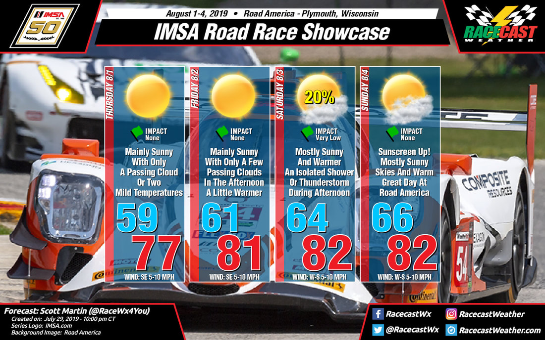
Racecast Weather - Your Source for Race Weather Information
  • Home
  • Racecasts
  • 2023 Schedule
  • Services
  • Contact
  • Bios
  • Links

Wednesday Night Update for IMSA at Road America

7/31/2019

Comments

 
By Scott Martin
Picture
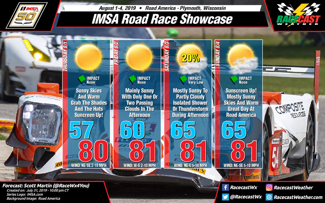
Not much change to the forecast at all as the global models are keeping Road America dry through most of the event weekend with the exception of Saturday. An isolated shower or thunderstorm is possible on Saturday afternoon, but chances are less than 20% at this point.

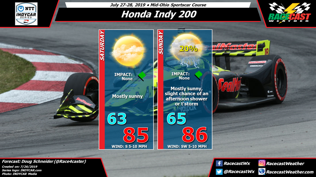
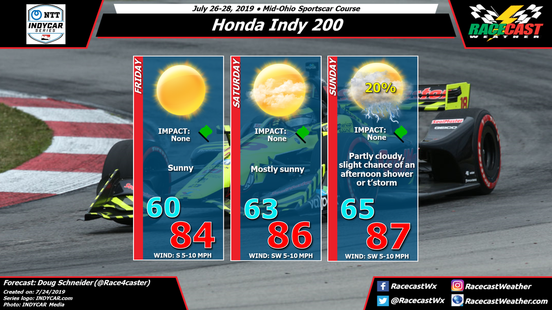
Thursday: Sunny skies and warm. Daytime high will be around 80 degrees after starting off in the upper 50s at 7:00 am. Winds will be out of the northeast at 2-5 MPH to start, but will shift out of the southeast at 5-10 MPH late in the day.

Friday: Pretty close to a carbon copy forecast to Thursday as there will be plenty of sunshine with the high reaching the lower 80s after starting of around 60 degrees at 7:00 am. Winds will be out of the W at 2-5 MPH to start, but will shift out of the south at 5-10 MPH by the afternoon.

Saturday: Skies will be mostly sunny to start, but clouds will begin to increase making it partly cloudy over Road America. There is a very small risk of an isolated shower or thunderstorm, but odds are really stacked against that at this point. The temperature will start off in the mid-60s at 7:00 am and will warm into the lower 80s for the daytime high. Winds will be out of the northeast to east at 5-10 MPH.

Sunday: A near perfect day for the main event at Road America. Mainly sunny skies with the daytime high reaching the lower 80s after temperatures start off in the mid-60s at 7:00 am. Winds will shift from out of the northeast at 2-5 MPH in the morning to out of the southeast at 5-10 MPH to end the racing day.

Remember, the weather is always changing, so modifications to the forecast can and will be made on the latest data. Radar will be up and running by Thursday afternoon. Have a great night.
Comments

Plenty Of Sunshine For IMSA At Road America

7/29/2019

Comments

 
By Scott Martin
Picture
​Great news for the fans attending the IMSA Road Race Showcase at Road America... All signs are pointing to a dry event weekend with the exception of maybe a stray isolated afternoon shower on Saturday afternoon.

Thursday will be a bright and sunny day with very comfortable temperatures and lower humidity levels. We'll start off near 60 degrees when the gates open at 7:00 am and warm into the upper 70s for the afternoon high. Winds will be out of the southeast for the most part at 5-10 MPH.

Nearly the same story for Friday as high pressure builds in bringing even more quiet weather with slightly warmer temperatures to the track. Plenty of sunshine once again with highs reaching the lower 80s. Winds will be out of the southeast at 5-10 MPH.

The latest GFS model run is showing a little tongue of moisture that will be moving southward through Wisconsin on Saturday that may be just enough to fire off a passing shower or two during the main heating of the day, but odds of that happening is really small, lower than 20% at this point. Skies will be mostly sunny with just a couple of clouds with highs reaching the lower 80s once again. Winds will start off out of the west at 5-10 MPH but will shift out of the south by the start of the afternoon.

Sunday will be another brilliant day at Road America as skies will be mainly sunny with warm temperatures. No rain is expected at this time and highs will reach the lower 80s. Winds will start off out of the west at 5-10 MPH but will shift out of the south by late afternoon.

Remember, the weather is always changing, so modifications to the forecast can and will be made on the latest data. Radar will be up and running by Thursday morning. Have a great night.
Comments

Race day forecast for the TOTAL 24 Hours of Spa

7/26/2019

Comments

 
By: Stephen McCoy
Picture
Picture
The start of the TOTAL 24 Hours of Spa currently looks to have the largest chance for precipitation for the race. A few outlier models indicate that precipitation may start in the morning, however model consensus supports the idea of the main showers beginning in the early afternoon during the build-up to the green flag. CAPE values for the start of the race are projected between 500-800 J/kg, which speaking from an American viewpoint is a small amount, however from a European standpoint it could be a moderate amount and enough to kick of thunderstorms in the mid-to-late afternoon. As Sunday approaches, thunderstorm potential should decrease as the convective energy will be used up by storms on Saturday. Fog may become an issue near sunrise due to the air at the surface becoming saturated either by precipitation or by ground evaporation. Precipitation chances will begin to trail off towards Sunday afternoon, though the high resolution models indicate that there may still be some isolated showers in the area; forthcoming runs could place one of these showers directly over the track, but for this forecast conditions remain mostly dry.
Comments

Friday forecast update for the Honda Indy 200 at Mid-Ohio

7/26/2019

Comments

 
By Doug Schneider
Picture
Nothing in the pattern has changed over the past couple of days to warrant a big change in the forecast for Mid-Ohio this weekend, so I'm sticking to my guns. Saturday should be a dry day with lots of sunshine a high temperatures in the mid 80s. 

Over the past few days, the NWS-Cleveland forecast has been switching back and forth between a small chance of rain Sunday and no mention of rain chances. This afternoon, they have removed their mention of a chance of rain. I'm going to keep a slight chance in my forecast because there is a weak low pressure trough that will be moving across the Great Lakes that day. While most of the rain with that system will stay north of Mid-Ohio, there will be some instability present across central Ohio that may allow for some showers and storms to develop farther south. There are a couple models that are showing this. I still think the chance of any rain at the track is small, just 20%, and it is unlikely that the race will be impacted. However, as I've been saying for the past few days, it cannot be ruled out entirely, and I'd rather stay consistent with my forecast unless there is a compelling reason to change it. 
Comments

Thursday update for the TOTAL 24 Hours of Spa

7/25/2019

Comments

 
By: Stephen McCoy
Picture
Picture
Conditions have far from improved for the TOTAL 24 Hours of Spa. Starting with tomorrow, temperatures are likely in the low 90's °F, low 30's °C with the latest model runs in a good amount of agreement. There could be a bit of variance in the temperature, as was seen today where a maximum temperature of 98 °F, 37 °C was recorded at Spa (my forecasted high temperature from Tuesday was 95 °F, 35 °C). The cold front mentioned in the previous forecasts is expected to pass through the region in the late afternoon to evening on Friday, bringing with it a slight chance of isolated showers. Model guidance suggests that most of the on-track sessions should be run as normal, though the Super Pole session could be impacted by showers in the area should they occur early enough; recent runs indicate showers starting around or just before 8:00 pm local time. Northwesterly surface winds behind the front will cause temperatures to drop during the morning with a low temperature on Saturday in the mid 60's °F, upper teen's °C.

I mentioned in the previous forecasts that if the front were to stall, the chances of precipitation would likely go up, which, according to the recent model runs, will turn out to be the case. A surface low pressure system to the southeast over southern Germany (extending into northern Italy) will cause winds from the southeast to push back against the cold front, stalling it to the east of the track. The cooler winds from the northwest will undercut the warmer air from the southeasterly winds, causing widespread precipitation throughout the day. Depending on timing/intensity of precipitation some of the sessions during the day may be delayed or even red-flagged. Showers will continue into the evening and overnight with chances tapering off somewhat into Sunday. However, chances for scattered showers are still possible, though timing is less concrete. Fog may be possible during the morning as air temperatures approach dew point temperatures. The surface to 500 millibar bulk shear indicates that the aforementioned low pressure system will move to the northeast during Sunday, allowing the front to continue to track eastward. This will allow winds to shift fully to the west to northwest, bringing the coolest temperatures of the weekend to the region.
Comments

Wednesday forecast update for the Honda Indy 200 at Mid-Ohio

7/24/2019

Comments

 
By Doug Schneider
Picture
There have been a couple slight changes to the forecast for Mid-Ohio today, but nothing major. It still looks like the weather will be good through the event, with warm temperatures each day, and just a slight chance of an afternoon storm on Sunday that is unlikely to have an impact.

Ohio is currently under a large high pressure ridge that has brought cool and dry air to the region. As I type this Wednesday afternoon, temperatures across central Ohio are in the lower to mid 70s, with low humidity. 

Over the next few days, the high pressure ridge will shift east, and a southerly flow will gradually bring more moisture and warmer temperatures to the area. By Friday, highs will be in the mid 80s. Humidity levels should still be fairly low, so it will still feel comfortable. Saturday will continue to trend warmer, with a little higher humidity. I have removed the slight chance of showers that I had in the previous forecast, because the models are trending slower with the increase in moisture. 

On Sunday, with moisture continuing to increase and a low pressure system approaching the Great Lakes region from the west, there may be enough instability to allow for isolated showers and thunderstorms in central Ohio during the afternoon. The chance of one of these showers hitting the track is low, just 20%. Because of that low chance, I am keeping the Impact at None. The chance of a dry race (80%) is much higher than the chance of any rain (20%), but I can't rule it out completely. High temperatures Sunday afternoon are expected to reach into the upper 80s, with the humidity making it feel like it's around 90. 
Comments

Tuesday update for the TOTAL 24 Hours of Spa

7/23/2019

Comments

 
By: Stephen McCoy
Picture
Picture
The forecast looked fairly straightforward for the TOTAL 24 Hours of Spa on Sunday, however today's model runs paint a bit of a different picture for this weekend's conditions.

On Thursday, surface winds are still expected from the south to southeast due to the combination of a high pressure system to the northeast and the aforementioned low pressures system to the northeast of the region. An upper level ridge centered over central Europe will suppress the air closer to the surface which will lead to warmer temperatures and mostly clear conditions through the day.

In the previous forecast, the models indicated that the cold front off the low pressure system would move through the Benelux region during the day on Friday. Since then, a trend among the models has pushed the frontal passage closer to Saturday with the it possibly stalling into a stationary front. This later passage means that Friday will have similar conditions to Thursday, though slightly cooler as the upper level ridge begins to move northwards out of the region. The models look to be in a general sense of agreement with timing of the initial passage as output suggests the high temperature for the day will occur in the early afternoon, a few hours before the high temperature usually occurs. Much like in the initial forecast, there is a chance of scattered showers with thunderstorms possible behind the front, but isolated showers ahead of the front are also not out of the question. Surface winds during the day will be continuing from the south to southeast initially before turning to the west to northwest after the front passes.

A lot of uncertainty has arisen for Sunday's conditions as the models are not in agreement for the front's position in the region. The GFS and German models indicate that the front will fully pass through the region, with temperatures dropping to the upper 50's °F, low-to-mid teen's °C  during the day as winds pile in from the west to northwest. Meanwhile the ECMWF shows conditions much warmer as the front stalls just to the west of the region, causing warmer temperatures closer to those seen on Saturday. In the former scenario, precipitation has a slight chance to linger into the morning, though without the convective environment from Saturday. Whichever the case may be, the conditions in the graphic will most likely change as the race draws closer.
Comments

First forecast for the Honda Indy 200 at Mid-Ohio

7/22/2019

Comments

 
By Doug Schneider
Picture
A fairly typical summer-time weather pattern is expected for Mid-Ohio weekend, with warm temperatures and a small chance of an afternoon shower or thunderstorm. 

A large high pressure ridge will provide dry and cooler-than-normal conditions across Ohio for the middle part of this week. As that high moves east, a southerly flow of warmer and more humid air will spread into the region on Friday. I think that conditions will remain stable enough on Friday that there won't be any potential for showers and thunderstorms to develop, but that may change for the weekend. As moisture increases, instability will increase and bring a chance of some storms developing with afternoon heating. Right now, I think the chance is small, just 20%, and the chance of any impact on the racing is very low. That could change as we get closer to the weekend. 
Comments
<<Previous

    Social Feeds


    Instagram


    Authors

    Doug Schneider
    Scott Martin
    Stephen McCoy

    Harris Cooley 


    Partners

    Picture
    Picture
    Picture
    Picture
    Picture

    Categories

    All
    F1
    IGTC
    IMSA
    Indycar
    Le Mans
    MRTI
    NASA
    Outlooks
    Photos
    PWC
    Racecasts
    SCCA
    SRO
    Trans Am
    TUSC
    Verification
    Weather Education
    WEC


    Archives

    March 2023
    February 2023
    January 2023
    December 2022
    November 2022
    October 2022
    September 2022
    August 2022
    July 2022
    June 2022
    May 2022
    April 2022
    March 2022
    February 2022
    January 2022
    December 2021
    November 2021
    October 2021
    September 2021
    August 2021
    July 2021
    June 2021
    May 2021
    April 2021
    March 2021
    January 2021
    December 2020
    November 2020
    October 2020
    September 2020
    August 2020
    July 2020
    June 2020
    March 2020
    January 2020
    December 2019
    November 2019
    October 2019
    September 2019
    August 2019
    July 2019
    June 2019
    May 2019
    April 2019
    March 2019
    February 2019
    January 2019
    December 2018
    November 2018
    October 2018
    September 2018
    August 2018
    July 2018
    June 2018
    May 2018
    April 2018
    March 2018
    February 2018
    January 2018
    December 2017
    November 2017
    October 2017
    September 2017
    August 2017
    July 2017
    June 2017
    May 2017
    April 2017
    March 2017
    February 2017
    January 2017
    December 2016
    November 2016
    October 2016
    September 2016
    August 2016
    July 2016
    June 2016
    May 2016
    April 2016
    March 2016
    February 2016
    January 2016
    December 2015
    November 2015
    October 2015
    September 2015
    August 2015
    July 2015
    June 2015
    May 2015
    April 2015
    March 2015
    February 2015
    January 2015
    December 2014
    November 2014
    October 2014
    September 2014


Powered by Create your own unique website with customizable templates.