Racecast Weather - Your Source for Race Weather Information
  • Home
  • Racecasts
  • 2025 Schedule
  • Services
  • Contact
  • Bios
  • Links

A Real Early Look At Barber Forecast For Indycar

3/28/2019

Comments

 
By Scott Martin.
Picture
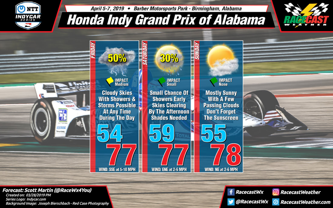
With this being our first look at what we can expect for the Honda Indy Grand Prix of Alabama weekend on April 5th-7th, we are still too far out to call an official forecast. Once we get into seven days of raceday, then we can start giving an official forecast instead of what the models are trending.

As of now, we have inconsistencies in both of the long-range models for the weekend ahead. The GFS is painting that Friday will feature cloudy skies with a good chance of showers and thunderstorms possible with around 0.50 inches of rain falling throughout the day. The European model shows a line of showers and storms approaching the area, but the rainfall tapers off before reaching the track. Skies look to be cloudy throughout the day with the European solution. Highs are trending to be in the upper 70s with the early morning low starting off in the mid-50s.

For Saturday and Sunday, the European model is keeping the track dry with skies clearing on the first half of Saturday and sunny skies on Sunday. It's a completely different story with the GFS as the latest run is keeping scattered showers and thunderstorms in the area throughout the weekend with rainfall amounts totalling 0.50 inches on Saturday and another 0.25 inches on Sunday. Temperatures are trending to start off around 60º on Saturday morning and climb into the upper 70s by the afternoon, and reaching the upper 70s again on Sunday after starting off in the mid-50s.

So, if it was within the seven-day window of raceday, the above graphic would be my forecast. But as we know, anything outside of seven days is considered at "Voodoo Land." The first official forecast will come on Monday morning (April 1st).
Comments

Tuesday update for the California 8 Hours

3/26/2019

Comments

 
By: Stephen McCoy
Picture
Only minimal changes were made to the forecast in this update for the California 8 Hours, most notably a lower chance for precipitation on Thursday. A slight chance for scattered showers is still present, but confidence is waning. Of the major computer models that we use for our forecasts, the Euro now stands alone when expressing rain during the day. However, the iterations of the model over the past day have yielded the same result, albeit indicating rain occurring more towards mid-day, which is too significant of a result to fully ignore. Should the Euro be correct, scattered showers will move through the region around noon from the north/northwest, though the model estimates precipitation rates around 1/100th of an inch per hour which would provide more of a nuisance than a major impact for the sessions on Thursday. The Euro is also indicating precipitation near the same magnitude Thursday night into Friday, but this would have no impacts to Friday's sessions.
Comments

Initial Forecast for the California 8 Hours

3/24/2019

Comments

 
By: Stephen McCoy
Picture
Some pleasant early-spring weather is in store for the California 8 Hours, but only after dealing with a slight chance for scattered showers on Thursday morning.

A trough in the upper levels over the Pacific Ocean is expected to move eastward towards the continental U.S. early this week. This trough will lead to the development of two surface low pressure systems in the Pacific off the west coast. The first system is expected to remain off the coast, moving northward into the mid-week. The cold front from this system will impact the region Monday and Tuesday, bringing high chances for precipitation to northern California. The second low pressure system is expected to be slightly stronger, with the cold front moving through the region on Wednesday, extending overnight into early Thursday. Much of the precipitation will exist along the front, however some lingering moisture from southwesterly flow in the lower levels of the atmosphere could threaten some of the earlier sessions on Thursday morning.

Winds Thursday morning will initially be from the south/southeast off the Santa Lucia Mountain Range before shifting to the west/northwest as the low pressure system moves north along the coast. Low level winds also from the west/northwest will cause some breezy conditions with gusts approaching 15 mph. The wind direction is expected to bring some moisture off Monterey Bay, resulting in partly cloudy conditions mid-day onward, though dry conditions aloft will decrease precipitation chances for Thursday afternoon and evening.

The rest of the weekend is expected to remain dry, with conditions on Friday and Saturday very similar to each other. An area of high pressure will build in behind the cold front on Wednesday/Thursday and move north up the coast during the weekend, keeping winds consistently from the north/northwest other than the mornings, where winds will again come from the south/southeast off the Santa Lucia Mountain Range. Winds on Friday are expected to orient in a more northwesterly direction which will bring some moisture off the bay and resulting in some partly cloudy conditions in the low levels. Saturday's winds are expected more from the north, resulting in fewer low level clouds as the winds traverse over more land than the water. However, an upper level ridge is expected to set up over the Pacific Ocean, funneling moisture from the equator to northern California. This could cause some upper level partly cloudy conditions to develop during the day on Saturday, but should have no impact on the race.
Comments

Sunday Morning Forecast Update For COTA

3/24/2019

Comments

 
By Scott Martin.
Picture
Forecast for today is still holding true at this point... we'll have mostly cloudy skies to start but the cloud cover will diminish somewhat leaving us with mostly clear skies by late afternoon. Highs will top out near 80 degrees. Winds will be out of the south-southwest at 8-12 MPH. No rain is expected throughout the day.
Comments

A Quick Friday Night Update On COTA Forecast; Plus, A Sneak Peek AT The Honda Indy GP Of Alabama

3/22/2019

Comments

 
By Scott Martin.
Picture
As of this late Friday night forecast update for the Indycar Classic weekend at Circuit Of The Americas, Saturday is starting to look even better as rain continues to be backing off some.

We'll have mostly cloudy skies throughout the day at the track with a small chance of a passing shower during the main heating of the day. The good news is that the higher resolution models are showing just a minimal amount of scattered showers around the area through the late morning and into the afternoon. Latest NWS projections are only showing 0.05 inches of rainfall for the area, which if any rain does fall, that will be just enough to bring out the rain tires for a brief stint. Temperatures will start off in the upper 50s at 8:00 am and top out in the lower 70s for the daytime high. Winds will be out of the south-southeast at 5-15 MPH and the chance of rain is only 30%.

For those hanging around for the concert during the evening, those rain chances drop even further to around 20%, but don't let that keep you from the fun. Temperatures will be close to 70 degrees at 6:00 pm and dropping into the mid-60s at 9:00 pm.

Skies will start off mostly cloudy on Sunday morning, but some of that cloud cover will erode away leaving us with partly cloudy to mostly clear skies by late afternoon. Morning temperatures will start off around 60 degrees at 8:00 am and will warm into the upper 70s close to 80 degrees by the afternoon. Winds will be out of the south-southwest at 6-12 MPH. All shower chances will be done well before sunrise at the track.

Radar is up and running on the website... and just a quick note about using the radar with a mobile device... view the website in desktop mode and you will be able to see all of the radar and zoom where you would like to.

And taking a quick peek into what I call "Voodoo Land" for what to expect in two weeks at Barber Motorsports Park for the Honda Indy Grand Prix of Alabama... According to long range models, Saturday and Sunday look to be dry at this point, but we may be dealing with some storms on Friday. I'm crossing my fingers that these will not be severe as it is the middle of Spring Severe Weather Season in Central Alabama. But that is still too far out to be specific, why I call it "Voodoo Land."
Comments

Rain Chances Continue To Drop For Indycar At COTA

3/22/2019

Comments

 
By Scott Martin.
Picture
Today will be a very nice day at COTA as we'll have mostly sunny skies throughout the day. Afternoon highs will top out in the upper 70s and winds will be out of the southeast at 5-10 MPH. No rain at this point, but clouds and a small chance of a passing shower or two become possible after sunset.

Saturday is looking better today as the models continue to show less activity in the area. While skies will be mainly cloudy throughout the day, the good news is that now it is only a small chance of scattered showers and thunderstorms. We'll start off in the upper 50s at 8:00 am and will climb into the lower 70s for the high. Winds will be out of the southeast at 6-12 MPH. Chance of rain is now down to 30%.

Even better news for Sunday as it looks like any rain chances will hold off until after sunset. Skies will be partly cloudy throughout the day but it will be a little breezy at times. We'll start off in the lower 60s at 8:00 am but will climb into the upper 70s to near 80 degrees for the high. Winds will be out of the south at 8-16 MPH.
Comments

Forecast Improving Somewhat For Saturday At COTA

3/21/2019

Comments

 
By Scott Martin.
Picture
The good news is that the forecast is starting to trend a little better for the event weekend as rain chances are starting to drop a little, especially for Saturday.

We'll start off with sunny skies on Friday morning with temperatures in the lower 50s at 8:00 am and winds out of the south-southwest at 2-5 MPH. Clouds will begin to move in during the day but we'll still end up with mostly clear skies by the end of the on-track activities. Afternoon highs will top out in the mid-70s with winds out of the south to southeast at 5-10 MPH. No rain is expected at this time.

We'll have a weaker system slowly moving by well off to the north of Texas on Saturday, but it will be close enough to fire off some scattered showers and maybe a few thunderstorms. The good news is that today's model runs have trended much drier throughout the day, but still show some activity in the area. We'll start off with cloudy skies and temperatures in the mid-50s at 8:00 am and will warm up to right around 70 degrees for the high. Winds will be south of the southeast at 6-12 MPH and the chance of rain will be around 40%. If any showers form and move over the track, they will be quick-hitters and shouldn't last that long at all.

Sunday will feature more clouds than sun to start, but the cloud cover will diminish somewhat, becoming partly cloudy by the end of the racing day. That system will still be close enough to the area that a stray shower or thunderstorm may fire up during the heating of the day, but at this point, the chances of that happening are slim. Temperatures will start off in the lower 60s at 8:00 am and top out in the upper 70s. Winds will be out of the south at 6-12 MPH throughout the day, and the chance of rain is only 20%.
Comments

Rain Still Expected On Saturday At COTA for Indycar

3/20/2019

Comments

 
By Scott Martin.
Picture
Picture
GFS Model valid from 7:00 am Friday to 7:00 pm Sunday (animation from TropicalTidbits.com).
As you can see by the above animation, rain still looks to be possible at times over Circuit Of The Americas throughout the weekend. There will be a weakening system moving through the area that will still have enough kick to fire off some scattered showers and thunderstorms during the a time frame that stretches from Friday evening through all of Saturday and Sunday.

At this point, all of the on-track activity for Friday will be dry as those shower chances do not ramp up until after 6:00 pm. Skies will be mostly sunny to start the day, but clouds will be moving in throughout the morning and afternoon hours. Morning temperatures will start off right around 50 degrees at 8:00 am and rise into the lower 70s for the daytime high. Winds will be out of the southeast at 1-5 to start and increasing to 5-10 by afternoon.

Really, there is no change to the forecast for Saturday... We'll have cloudy skies throughout the day with the possibility of showers and thunderstorms moving across the track at any time. Morning temperatures will start off in the lower 50s and only make it into the upper 60s by the afternoon. Winds will be out of the southeast at 6-12 MPH. The chance of rain for Circuit Of The Americas at this point is at 50%. Rainfall amounts throughout the day should end up around 0.25 inches.

With the possibility of lightning, you will have to be weather aware while at the track. If you hear thunder, you are close enough to the parent thunderstorm to be struck by lightning. Find a sturdy building or a hard top vehicle to see shelter until the storm passes. The good news is that there are no strong to severe storms expected, so you don't have to worry about strong winds or tornadoes.

Sunday will be a much warmer day at the track with more clouds than sun, but we will continue to have a very small chance of a passing shower or thunderstorm. The good news is that the model has been trending a little drier on this run so rainfall amounts, if any falls, should be around 0.05 inches... maybe just enough to bring out the rain tires for a stint. We'll start off in the lower 60s at 8:00 am and warm into the mid-70s for the afternoon high. Winds will be out of the south at 6-12 MPH. The chance of rain for Circuit Of The Americas at this point is at 20%.
Comments
<<Previous

    Social Feeds


    Instagram


    Authors

    Doug Schneider
    Stephen McCoy

    Harris Cooley 


    Categories

    All
    F1
    IGTC
    IMSA
    Indycar
    Le Mans
    MRTI
    NASA
    Outlooks
    Photos
    PWC
    Racecasts
    SCCA
    SRO
    Trans Am
    TUSC
    Verification
    Weather Education
    WEC


    Archives

    February 2025
    January 2025
    December 2024
    November 2024
    October 2024
    September 2024
    August 2024
    July 2024
    June 2024
    May 2024
    April 2024
    March 2024
    February 2024
    January 2024
    December 2023
    November 2023
    October 2023
    September 2023
    August 2023
    July 2023
    June 2023
    May 2023
    April 2023
    March 2023
    February 2023
    January 2023
    December 2022
    November 2022
    October 2022
    September 2022
    August 2022
    July 2022
    June 2022
    May 2022
    April 2022
    March 2022
    February 2022
    January 2022
    December 2021
    November 2021
    October 2021
    September 2021
    August 2021
    July 2021
    June 2021
    May 2021
    April 2021
    March 2021
    January 2021
    December 2020
    November 2020
    October 2020
    September 2020
    August 2020
    July 2020
    June 2020
    March 2020
    January 2020
    December 2019
    November 2019
    October 2019
    September 2019
    August 2019
    July 2019
    June 2019
    May 2019
    April 2019
    March 2019
    February 2019
    January 2019
    December 2018
    November 2018
    October 2018
    September 2018
    August 2018
    July 2018
    June 2018
    May 2018
    April 2018
    March 2018
    February 2018
    January 2018
    December 2017
    November 2017
    October 2017
    September 2017
    August 2017
    July 2017
    June 2017
    May 2017
    April 2017
    March 2017
    February 2017
    January 2017
    December 2016
    November 2016
    October 2016
    September 2016
    August 2016
    July 2016
    June 2016
    May 2016
    April 2016
    March 2016
    February 2016
    January 2016
    December 2015
    November 2015
    October 2015
    September 2015
    August 2015
    July 2015
    June 2015
    May 2015
    April 2015
    March 2015
    February 2015
    January 2015
    December 2014
    November 2014
    October 2014
    September 2014


Powered by Create your own unique website with customizable templates.