|
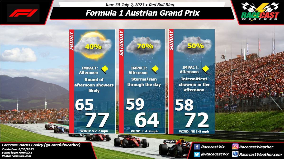
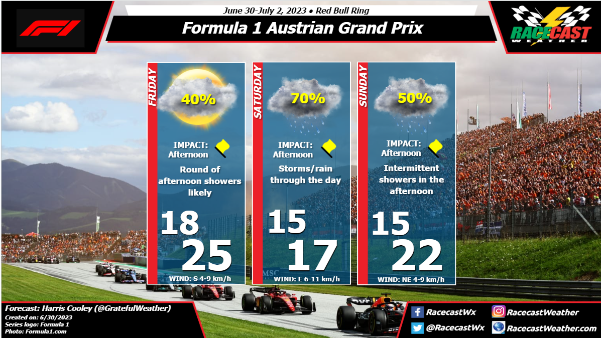
By: Harris Cooley A rainy weekend is in store for the Austrian GP with cool temps as well. There is little deviation from overcast skies and calm winds through Sunday leaving this race up to lots of skill and a little bit of luck for these teams. We can expect the track to be wet for most of the driving with short breaks of occasional sunshine. I will be monitoring these conditions as they unfold and release updates as needed. Wet tyres can be the heavy favorite in this one. A metric graphic is posted below...
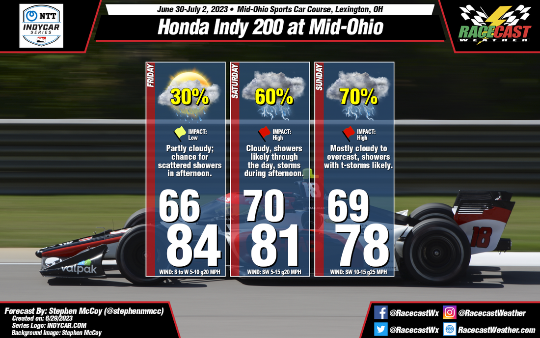
By: Stephen McCoy Expected conditions are far from improved for Mid-Ohio this weekend. Temperatures, winds, and cloud cover remain mostly consistent with the initial forecast, however rainfall chances and impacts have increased significantly for the latter portion of the weekend.
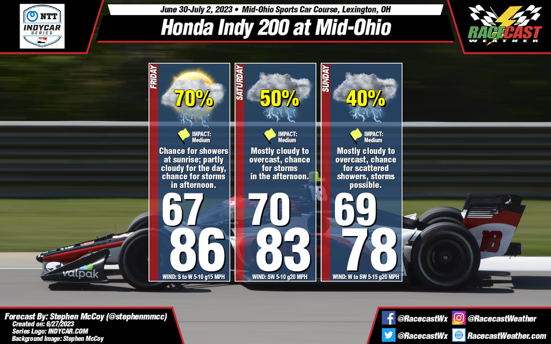
Friday's synoptic pattern is still likely to occur as was suggested in the initial forecast from Tuesday. A low pressure system will be centered over Ontario to the north of the region, with a surface high located over the southeastern US. The anticyclonic motion around the high will bring moisture from the Gulf of Mexico north through the Great Plains and into the Midwest. The additional moisture will result in dew point temperatures hovering in the low 70's. Air temperatures in the mid 80's with mean heat index values will approach the low 90's for a high. Moisture in the low levels will bring cloudier conditions to the region, especially for the afternoon and may result in a few scattered showers in the area. Temperatures will cool slightly for the remainder of the weekend as cloudier conditions move in. Saturday and Sunday will see medium to high impacts for on-track sessions as showers and thunderstorms are likely during the afternoons. Each day could see upwards of 1/2" of rainfall, but the main safety concern will be lightning within the storms. By: Stephen McCoy The weather setup for this weekend's races at Mid-Ohio are not looking too favorable in the initial forecast. Mostly cloudy for the better portion of the event with chances for rainfall each day. Couple that with high dew point temperatures will make for muggy conditions for at least part of the weekend.
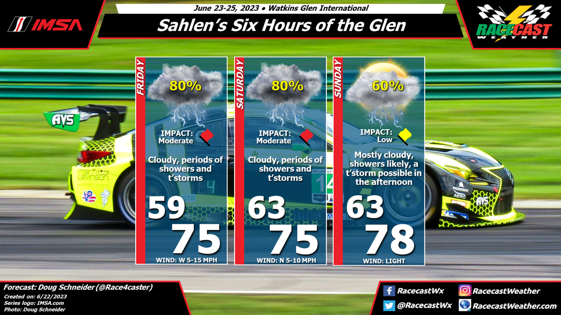
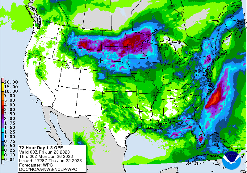
Entering the weekend, the mid Ohio region will be located between two major synoptic systems. A low pressure system is expected to be centered over Ontario, Canada with an area of high pressure located over the Southeastern United States. The anticyclonic rotation around the high will wrap moisture from the Gulf of Mexico through the southern Great Plains and into the Midwest, where the steering flow will be partially influenced by both pressure systems. A similar pattern will extend into the mid and upper levels of the atmosphere, resulting in plenty of cloud cover over the region. For Friday, conditions will start mostly cloudy with a chance for showers as a surface trough approaches the region from the West, extending from the low pressure system over Ontario. Conditions will begin to clear for the late morning and early afternoon, which will cause temperatures to warm into the mid 80's for a high. The added moisture to the region will mean dew point temperatures will reach the mid 70's, resulting in heat index values in the mid 90's for the afternoon. Cloud cover will increase during the afternoon and evening as scattered thunderstorms may develop. The aforementioned synoptic pattern is expected to continue into Saturday, resulting in mostly cloudy conditions through the day with heat index values in the low 90's. Scattered thunderstorms are possible again in the afternoon, which may have major impacts for the on-track sessions. Similar conditions may be present on Sunday, but with slightly cooler temperatures as winds shift to the West. By Doug Schneider The forecast for Watkins Glen continues to look very wet this weekend. A low pressure system that has brought a lot of rain to the Southeast over the last few days will continue to track slowly northeast. The counter-clockwise flow around this low will draw a lot of moisture off the Atlantic Ocean into upstate New York, causing periods of showers and thunderstorms at the track on Friday and Saturday. The northeast movement of the low will take it east of the Finger Lakes region on Sunday, which will lower the chance of rain and allow for some partial sunshine, but I expect that afternoon instability will cause scattered showers to develop in the area. The uncertainty in this forecast is how much rain will fall. There is a potential for heavy rainfall at times, especially Friday and Saturday. This could cause delays to the on-track activity, as well as localized flooding. Campers should avoid setting up tents in low lying areas which may be prone to flooding. Lightning will also be an issue to stay aware of - make sure you have a place to find shelter when thunder is heard, like inside a car or a building. The National Weather Service Weather Prediction Center forecast rain amounts are around 0.25 to 0.5 inches on Friday, 0.5 to 0.75 inches on Saturday, and 0.1 to 0.25 inches on Sunday. So the range of possible amounts for the event is expected to be between 0.8 and 1.5 inches total. Here's their graphic of rain amounts for Friday through Sunday. Follow @RacecastWx on Twitter, as I'll try to post regular radar updates through the event. If you're at the track, please tag us in your photos.
By Doug Schneider A wet weather pattern will be in place across upstate New York this weekend, making for a soggy Sahlen's Six Hours of the Glen.
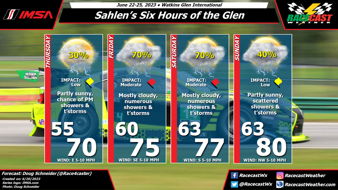
Thursday will likely have the best weather of the event, with just a small chance of an afternoon shower or thunderstorm. The chance of rain will trend upward, due to a slow-moving low pressure system over the Ohio Valley region that will pump moisture into the Finger Lakes region over the weekend. As the low tracks slowly northeast, showers and thunderstorms will become numerous Friday and Saturday. The highest chance of showers and storms will be in the afternoon hours, but they are possible at any time of the day. I expect that the rain may be heavy at times, along with frequent lightning, which may cause delays and stoppages during some of the on-track sessions. The low pressure system will be over New England by Sunday, which will cut off the feed of moisture to the area, and lower the chance of showers and storms. Still, there could be enough instability to produce some scattered afternoon activity that could impact the race. With some periods of sunshine between the clouds, temperatures could rise to around 80 degrees. Check back later in the week for updates. By Doug Schneider Overall, the weather looks great for racing as GT World Challenge visits VIR this weekend.
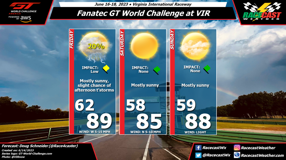
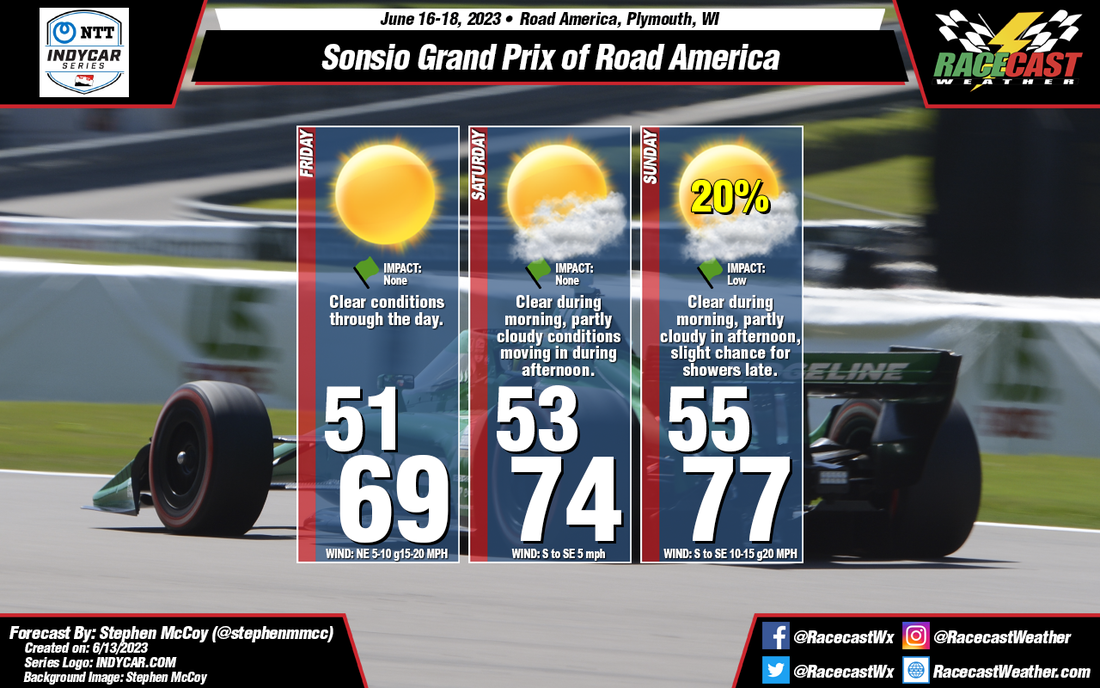
An upper levels disturbance will be dropping southeast out of the central Appalachian region on Friday, and this may spark some afternoon shower and thunderstorms across the Blue Ridge. Some of the storms could get close to VIR, but the chance of having one pass over the track is low, only about 20%. If a storm does pass over the track, the main impact will be lightning, and it should pass through quickly. A cold front moves through the area Friday night, and high pressure will build in from the north. This will provide very nice conditions for Saturday and Sunday. Although temperatures will be warm both days, with highs in the mid to upper 80s, the morning lows will be fairly cool, in the upper 50s. Humidity levels will be relatively comfortable too, considering it's June in southern Virginia, as the afternoon dewpoint temperatures will drop into the low 50s on Saturday, and the mid to upper 50s on Sunday. By: Stephen McCoy For the weekend, an upper level high pressure ridge will be located over much of the northern Midwest, maintaining dry conditions aloft. For Friday, a surface high pressure system will extend southwest from central Canada into the Great Lakes region. The anti-cyclonic flow around the pressure system will result in winds over eastern Wisconsin largely from the northeast, bringing below-normal temperatures to the region. As with the upper levels, dry air will be persistent in the lower levels, resulting in clear conditions throughout the day.
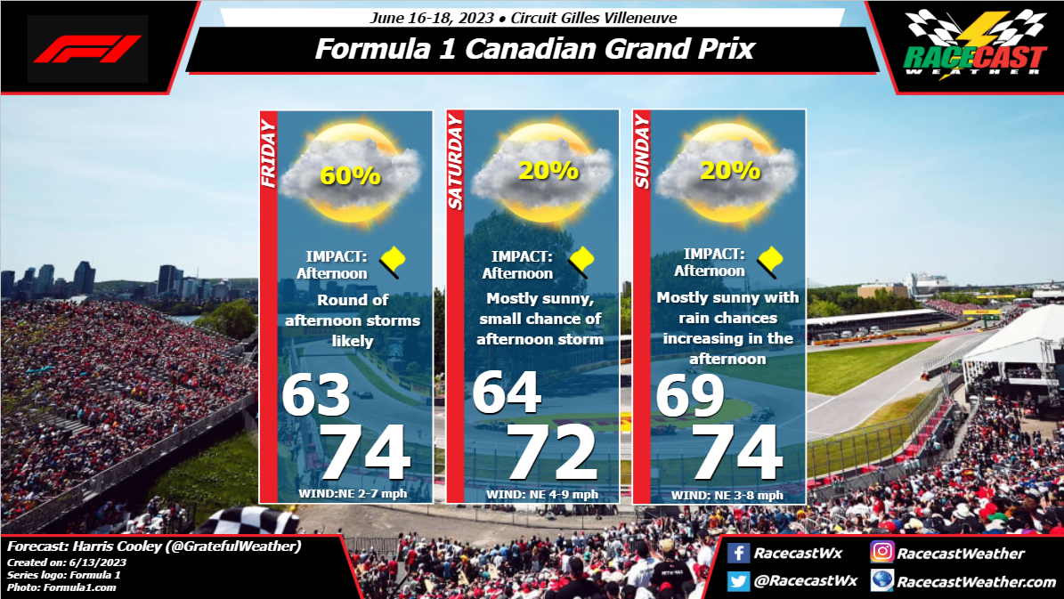
Saturday will start much like Friday with minimal cloud cover, but with temperatures beginning to return to normal as the surface high pressure breaks down over the region. With no steering factor, surface winds will be relatively calm; a low pressure system approaching the region from the south on Sunday will cause winds to gradually shift to the southeast. Much like Friday, no rainfall is expected as dry air remains over the area. As previously mentioned, a low pressure system over the southern plains will make an approach towards the Midwest on Sunday, shifting winds to the southeast. A local high pressure system will also develop over the northern Great Lakes, which will intensify surface winds from Saturday; gusts during the day could reach 20 mph. Minor cloud cover may move in for the afternoon in the low and mid levels as the pressure system moves towards the region. Rainfall is unlikely during Sunday's race, though some isolated showers may be possible during the evening. By: Harris Cooley A low pressure system will be slowly moving east of the region as the weekend goes on keeping a NE flow bringing moisture/cloud coverage to the track. Wind speeds will be light to moderate which will further help mix the air a bit and lead to clouds/potential storms in the afternoons through the weekend. Teams should have their radar up through the weekend if they want a competitive advantage because these conditions will be volatile. Staying ahead of the weather will be a key pillar in performing well this weekend. A metric graphic is posted below...
|
Social Feeds
Authors
Doug Schneider Partners
Categories
All
Archives
December 2023
|

