Racecast Weather - Your Source for Race Weather Information
  • Home
  • Racecasts
  • 2023 Schedule
  • Services
  • Contact
  • Bios
  • Links

USAF NASA 25 Hours of Thunderhill Forecast Update, Powered By LuxPerformance.com

11/29/2018

Comments

 
By Scott Martin
Picture
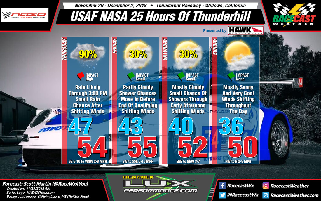
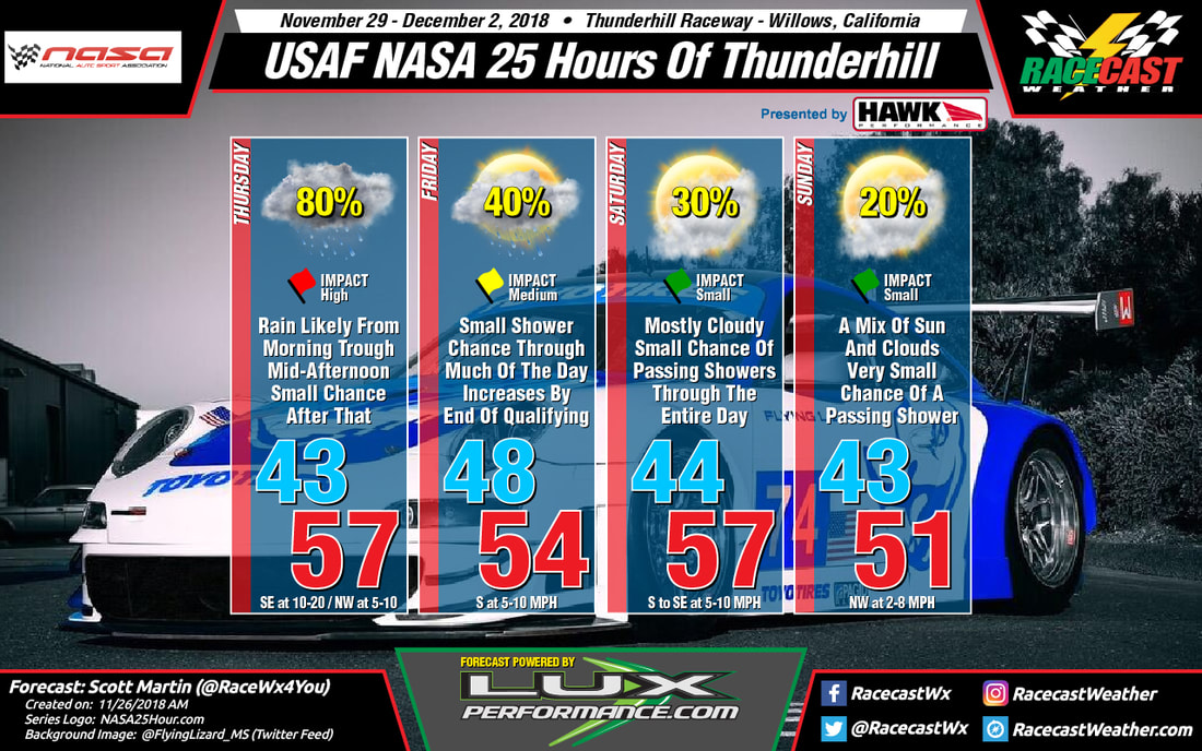
Conditions throughout the event weekend are beginning to look a little better as overall rain chances have dropped for the actual race, but Thursday's testing sessions will be pretty wet. Rainfall totals throughout the morning and early afternoon hours could total up to or just over 0.25 inches. Winds will be shifting throughout the day starting off out of the southeast at 5-10 MPH but will end up out of the west-northwest at 2-8 MPH by the end of the day. Today's high will top out in the mid-50s and will drop into the upper 40s by the time the paddock closes at midnight. Chance of rain throughout much of the day will be around 90% but will drop to around 30% after 3:00 pm.

Much of the on-track activity will be dry on Friday, but rain chances creep back into the forecast after 3:00 pm, which could affect the qualifying sessions. The good news is that the rainfall appears to be light but may be just enough to bring out the rain tyres. It will be partly cloudy throughout the day and the afternoon high will be in the mid-50s. Rain chances are nearly 0% through much of the day, but increases to 30% after 3:00 pm.

The good news for the main event, The USAF NASA 25 Hours of Thunderhill, should be dry for at least 21 out of the 25 hours. A few light showers may dampen the track during the morning and into the early afternoon hours on Saturday, but those rain chances will only be around 30%. After 3:00 pm, the remainder of the race will be dry, but temperatures will be very cool to pretty chilly. Saturday's high will be in the lower 50s, then falling into the mid-30s for the early morning low on Sunday morning, before warming back into the upper 40s by the checkered flag.

I'll have radar up and running before 10:00 am PST today.
Comments

First Forecast For The 25 Hours Of Thunderhill, Powered By LuxPerformance.com

11/26/2018

Comments

 
By Scott Martin.
Picture
Thursday looks to be a pretty grey and possibly wet throughout the day. Rain will be likely during the morning and much of the afternoon, but those rain chances drop of for the late afternoon through the evening hours while skies become partly cloudy. Temperatures will be in the lower 50s at 7:00 am, warming into the upper 50s for the daytime high, then dropping into the lower 40s at midnight. Rain chances will be around 80% for the morning and into the early afternoon hours, then dropping to around 30% for the remainder of the on-track activity. Winds will start off out of the southeast at 10-20 MPH but will shift out of the northwest by late afternoon at 5-10 MPH.

Friday looks a little better than Thursday, but we'll continue to have a small chance of showers throughout the day. Skies will be partly to mostly cloudy with temperatures at 9:30 am in the upper 40s, topping out in the mid-50s for the afternoon high, and dropping into the lower 50s by the end of the qualifying session at 5:45pm. Rain chances will be around 20% for much of the on-track activity, but increasing to near 40% before the end of qualifying. Winds will be out of the south at 5-10 MPH.

Mostly cloudy skies and a small chance of showers will continue throughout the day on Saturday as the race is scheduled to start just after 11:00 am. Rain chances will be around 30% from the pre-grid at 9:30 am through mid-afternoon, then drops off a little to around 20% for the rest of the afternoon through midnight. Temperatures at the green flag will be in the lower 50s, topping out in the upper 50s for the high, then dropping into the mid-40s by midnight. Winds will be out of the south to southeast at 5-10 MPH.

While we should be mainly dry with partly cloudy skies during the early morning hours on Sunday through the checkered flag at noon and the awards ceremony to follow up during the afternoon, there still remains a very small chance of showers (less than 20%). Temperatures will remain dropping from the mid-40s at midnight to the lower 40s by 3:00 am, but they will begin to climb steadily into the lower 50s by 12:00 pm. Winds will be out of the northwest at 2-8 MPH.
Comments

Race day forecast for the Six Hours of Shanghai

11/17/2018

Comments

 
By Doug Schneider
Picture
Picture
Rain is still on track to affect the Six Hours of Shanghai. The time period when the greatest rain is expected to occur is in the late morning through early afternoon hours, between 10 am and 2 pm. The rain may be heavy enough during that time to cause some delays to the race. After that time, the rain should tend to become lighter. The total amount of rain expected through the race is about a half inch (13 mm). 
Comments

Thursday update for the 24 Hours of COTA

11/15/2018

Comments

 
By: Stephen McCoy
Picture
Picture
No major changes in the forecast for this weekend's race at Circuit of the Americas, though the models are still showing a wide range of temperatures for the high on Sunday. Confidence is not high for the temperature as a result of the model spread. In addition, timing of the high is uncertain, but looks increasingly like it will occur in the morning due to the cold front moving in and dropping temperatures for the rest of the day.
Picture
The SREF plumes ensemble spread shows a mean temperature around 50F on Sunday, though with very low confidence as not a single member matches the mean line.
Picture
The 06Z and 12Z GFS model runs (blue lines) show a spike in temperatures on Sunday as the model shows the front passing in the afternoon, allowing temperatures to warm from daytime heating. However, the 06Z and 12Z runs of the NAM (red lines) show the front passing in the morning, with cold air moving in from the north behind the front. Daytime heating still occurs in the NAM runs, but the effect occurs hours after the front has passed.
Comments

Forecast update for the Six Hours of Shanghai

11/14/2018

Comments

 
By Doug Schneider
Picture
Picture
Comments

Initial forecast for the 24 hours of COTA

11/12/2018

Comments

 
By: Stephen McCoy
Picture
Picture
Slightly below-average temperatures are in the forecast for the 24 Hours of COTA, with sunny and breezy conditions on Friday giving way to more cloudy and windier conditions on Saturday and Sunday. Timing of  a cold front passage on Sunday could determine if temperatures remain in the 60's F or drop to the lower 50's F for the day.

A strong upper level shortwave trough will move through the region towards the southeast US through the beginning of the week into Thursday. A surface low pressure system is expected to develop over the Gulf Coast ahead of the trough, moving northeast up the Atlantic coast late Thursday; an area of high pressure will build at the surface as the low move out of the region. Behind the upper level trough, conditions will return to zonal flow, with winds coming from due west through the end of the week.

Sunny conditions are expected on Friday with dry air moving in to the region at all levels of the atmosphere. Initial surface winds from the southwest will contribute to a low temperature in the mid 40's F, however as the day progresses, winds will shift towards the south as the surface high pressure system slowly tracks eastward across Louisiana and Mississippi. The winds will bring warmer air from the Gulf to central Texas, resulting in high temperatures in the mid 60's F.

Similar conditions are expected on Saturday, with the exception of clear skies, as the zonal flow in the upper levels will bring moisture originating over the Pacific into the area. Conditions will likely start clear in the morning, but cloud cover will increase through the day as the upper level moisture moves over around mid-day. Surface winds will shift slightly during the day to the southeast, causing temperatures to be slightly warmer in the upper 60's F.

Going back to Wednesday, a surface low pressure system will develop over Canada (known as an "Alberta Clipper") and track eastwards through the week. After approaching the Great Lakes region on Saturday, a cold front will extend from the system well to the southwest, reaching into Oklahoma and northern Texas. As the low continues its track, the cold front will track southward, approaching central Texas by Sunday morning. There is currently a split in the models as to when the front will reach the region, with the ECMWF indicating a passage in the early morning before sunrise and the GFS indicating a passage closer to mid-day.

This graphic follows the synoptic pattern provided by the GFS where southeasterly winds from Saturday continue to bring warmer temperatures into Sunday morning before the frontal passage. The result would be a low temperature about 10 degrees warmer than Friday and Saturday. The high temperature would only be a few degrees warmer than the low as the front would only allow daytime heating to occur for a couple of hours before it passes and drops temperatures into the lower 50's F. If the Euro is correct, temperatures will be cooler than on this graphic with the high temperature occurring just after sunrise before dropping to the lower 50's F for the remainder of the day. Regardless of timing of the frontal passage, winds will shift to the north, with wind speeds around 10-15 mph and gusts approaching 25 mph. The front will also bring overcast conditions to the region for most of the day.
Comments

First forecast for the Six Hours of Shanghai

11/12/2018

Comments

 
By Doug Schneider
Picture
Picture
The weather pattern across eastern China this weekend will be a wet one that will not change much from one day to the next, which means that rain will be a factor in the racing each day.

A front is expected to stall near the Shanghai area on Thursday. Moist air spreading from south to north will run up and over this front. A steady rain will start on Thursday night and continue through Friday. The upper level flow will be from west to east, parallel to the front, so the front will not move much over the weekend. It may drift slightly south, but that should have little impact on the weather, as rain will likely continue into Saturday, and probably into Sunday. One positive aspect of this forecast is that the rain does not appear to be heavy. I expect it will be a steady, persistent light rain that will produce about a quarter to half an inch  (6 to 13 mm) each day. As a result, I have a Low impact each day, meaning that rain tires will be needed and there may be some delays to the action, but I do not expect the rain to be heavy enough to cause cancellations. 

That's how the forecast looks today, and I plan to have the next update posted on Wednesday, unless there is a big change in the models before then.
Comments

Friday update for the Michelin IMSA SportsCar Encore at Sebring

11/9/2018

Comments

 
By: Stephen McCoy
Picture
Conditions remain mostly the same for Saturday and Sunday at Sebring. Widespread fog is possible in the morning on Saturday though conditions will clear before mid-day. Partly cloudy skies are expected for the earlier portions of the day before transitioning to mostly cloudy skies as the cold front passes over. On Sunday, a slight chance for scattered afternoon showers is re-introduced as northeasterly winds are expected to bring moisture from the Atlantic to the region which will contribute to the chance for precipitation. However, chances are only at 20% due to output from the simulated reflectivity parameter of the NAM 3km model showing mostly scattered showers in the area with little to no rain occurring at the track.
Comments
<<Previous

    Social Feeds


    Instagram


    Authors

    Doug Schneider
    Scott Martin
    Stephen McCoy

    Harris Cooley 


    Partners

    Picture
    Picture
    Picture
    Picture
    Picture

    Categories

    All
    F1
    IGTC
    IMSA
    Indycar
    Le Mans
    MRTI
    NASA
    Outlooks
    Photos
    PWC
    Racecasts
    SCCA
    SRO
    Trans Am
    TUSC
    Verification
    Weather Education
    WEC


    Archives

    March 2023
    February 2023
    January 2023
    December 2022
    November 2022
    October 2022
    September 2022
    August 2022
    July 2022
    June 2022
    May 2022
    April 2022
    March 2022
    February 2022
    January 2022
    December 2021
    November 2021
    October 2021
    September 2021
    August 2021
    July 2021
    June 2021
    May 2021
    April 2021
    March 2021
    January 2021
    December 2020
    November 2020
    October 2020
    September 2020
    August 2020
    July 2020
    June 2020
    March 2020
    January 2020
    December 2019
    November 2019
    October 2019
    September 2019
    August 2019
    July 2019
    June 2019
    May 2019
    April 2019
    March 2019
    February 2019
    January 2019
    December 2018
    November 2018
    October 2018
    September 2018
    August 2018
    July 2018
    June 2018
    May 2018
    April 2018
    March 2018
    February 2018
    January 2018
    December 2017
    November 2017
    October 2017
    September 2017
    August 2017
    July 2017
    June 2017
    May 2017
    April 2017
    March 2017
    February 2017
    January 2017
    December 2016
    November 2016
    October 2016
    September 2016
    August 2016
    July 2016
    June 2016
    May 2016
    April 2016
    March 2016
    February 2016
    January 2016
    December 2015
    November 2015
    October 2015
    September 2015
    August 2015
    July 2015
    June 2015
    May 2015
    April 2015
    March 2015
    February 2015
    January 2015
    December 2014
    November 2014
    October 2014
    September 2014


Powered by Create your own unique website with customizable templates.