Racecast Weather - Your Source for Race Weather Information
  • Home
  • Racecasts
  • 2023 Schedule
  • Services
  • Contact
  • Bios
  • Links

Friday forecast update for the Detroit Grand Prix at Belle Isle Park

5/31/2019

Comments

 
By Doug Schneider
Picture
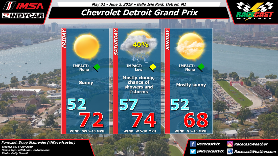
The forecast graphic for the Detroit Grand Prix hasn't changed much from Wednesday, but there are some details on the timing of rain chances on Saturday that are coming into better focus today. More details on that below.

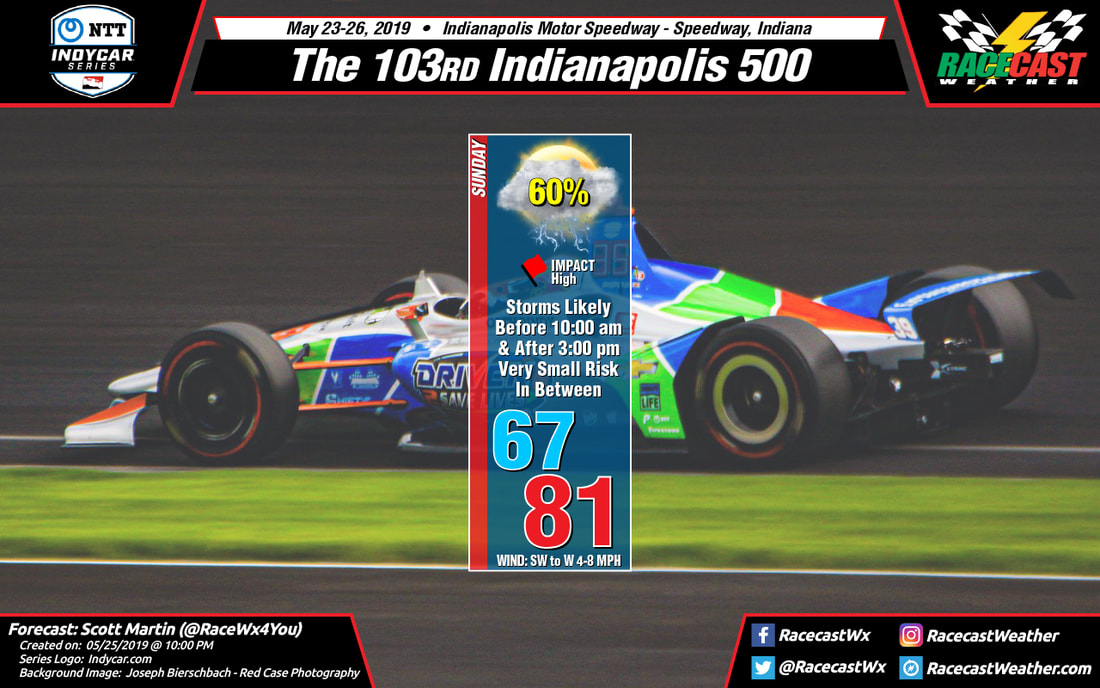
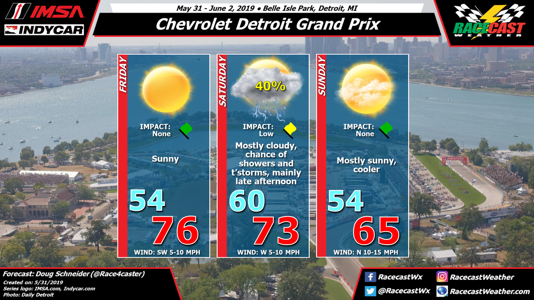
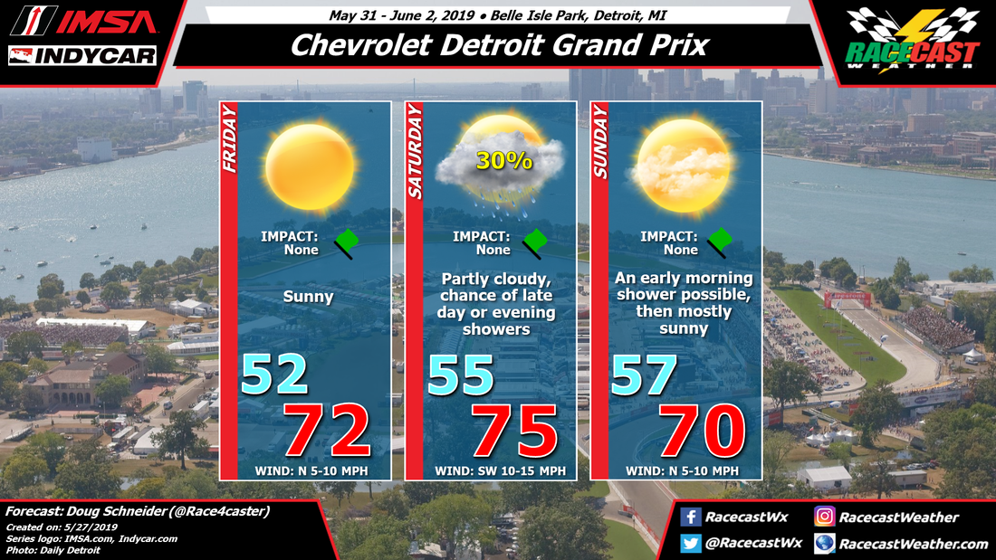
Today continues to look like a beautiful day at Belle Isle Park. There will be abundant sunshine and warm temperatures in the mid 70s. Admission is free today so get out and enjoy some great racing in perfect weather.

A cold front will be approaching Belle Isle from the north on Saturday, which will bring a chance of showers and thunderstorms. There could be showers in the area as early as the pre-sunrise hours of Saturday morning, but if these did occur they would be light and just wet the track a little. Scattered showers will be possible through the morning, but the chance of rain will be rising through the afternoon and evening, as will the threat of thunderstorms. This means that the IndyCar race, which is scheduled from 3:50 pm to 5:45 pm, will have the best chance of rain of Saturday's races. The exact timing of rain is too uncertain to say whether the race will be wet or dry at this time, but I would put the chance of at least part of the race being run in wet conditions at 40%. It is possible that rain could hold off until after the racing ends for the day, and I would put the chance of that happening at 60%. 

With thunderstorms being possible on Saturday, fans at the track should stay weather aware, and have a plan to find shelter, preferably in a building, when thunder is heard.

Showers and thunderstorms are likely after sunset Saturday evening as the cold front moves through. High pressure will build in from the north on Sunday, providing cooler temperatures and low humidity. It will be a beautiful day to take in a race, with mostly sunny skies and highs in the mid 60s. It will be a little breezy, with a north wind at 10 to 15 mph.
Comments

Wednesday forecast update for the Detroit Grand Prix at Belle Isle

5/29/2019

Comments

 
By Doug Schneider
Picture
The main change to the forecast for the Detroit Grand Prix with today's update is to shift the timing of rain chances on Saturday a little earlier. This could have the potential of impacting some races on Saturday, but which races will be impacted is still uncertain as there is not good model agreement on timing. 

Friday continues to look great as a cold front will move through the area on Thursday and a dry and cool air mass will follow it. With plenty of sunshine, highs on Friday will be in the lower 70s. 

Another low pressure system and its associated cold front will approach the area on Saturday. One model, the GFS, brings this front through on Saturday morning, which would put the chance of rain mainly in the morning and leave a dry afternoon. However, two other models that I have more confidence in, the NAM and ECMWF, have their rain chances with the cold front coming in the afternoon and evening. I think this later timing is more likely to occur than the earlier timing, but I can't rule out showers at any time of the day. With the afternoon timing of the cold front, there may be more instability available for thunderstorms, so I've added that to the forecast. This does not appear to be a rain-out situation at all - just scattered showers and possibly a thunderstorm in the area for a brief period, so I have the Impact as low. Even if a storms passes over Belle Isle, it should only produce around a tenth of an inch of rain. 

Behind the cold front on Sunday, there will be mostly sunny skies, low humidity, and cooler temperatures. Morning lows will be in the lower 50s, with highs in the upper 60s. 
Comments

First forecast for the Detroit Grand Prix at Belle Isle

5/27/2019

Comments

 
By Doug Schneider
Picture
Overall, the weather looks really nice for the Detroit Grand Prix weekend. Don't let that rain chance on Saturday keep you away. With Trans Am, IMSA, and IndyCar in action, it should be a great event to attend. 

As teams set up at Belle Isle on Thursday, there will be rain in the area. A cold front will be pushing through the area, and while the heaviest rain will be to the south across Ohio, up to a quarter inch of rain may fall at Belle Isle on Thursday. 

Once the front exits Thursday night, a cool and dry air mass will build in from the north. Friday will be a beautiful day for racing, with sunshine and high temperatures in the lower 70s. Even better, Friday is Comerica Bank Free Prix Day, with no charge for admission. Free racing and nice weather - it doesn't get any better!

Saturday will have more cloud cover, but still a fair amount of sunshine, mainly in the morning. A southwest wind at 10 to 15 mph will raise temperatures into the mid 70s in the afternoon. Clouds will be increasing through the day as another cold front approaches from the north. However, at this time I expect that any rain with the front will hold off until after the racing is done for the day (the IndyCar race ends at 6 pm). There is a concert after the race which may have a chance of being impacted, but at this time I only have a 30% chance of rain during the daylight hours. Rain is most likely to arrive overnight. 

The cold front should be through the area by the time on track action starts on Sunday morning at 10:45. There is a chance of the timing changing with later forecasts, but for now I'm going with a dry and mostly sunny day. Winds will shift to the north behind the front, with temperatures topping out around 70. 
Comments

Brief Sunday Morning Forecast Update: Indy 500

5/26/2019

Comments

 
By Scott Martin
Picture
As of 9:00 am ET this morning, much of the rain activity is staying north of the track and I believe we are entering into the lull that I talked about in last night's forecast, just starting about an hour earlier. So far, the radar trends are showing that anything west of the speedway is moving to the east-northeast and is somewhat dissipating.

Forecast models continue to show the lull in the activity from now through at least 3:00 pm, but I still can't rule out a stray shower or two during this time, but chances of that happening will be small. Chance of rain will be around 20-30% between now and 2:00 pm, but ramps back up to 60% by 3:00 pm. The good news is that any shower and storm activity looks to be scattered in nature, so not everyone in Central Indiana will get rain late this evening, but chances will be likely.

So, the forecast that I gave last night, I still feel like that will be the way I go for this morning. Let's hope that Mother Nature sticks to it as well.
Comments

Late Saturday Night Forecast Update: Indy 500

5/25/2019

Comments

 
By Scott Martin.
Picture
The 10:00 pm ET forecast update for Sunday at the Indianapolis Motor Speedway and the high resolution models are continuing to show some promise to get most of the race in... if not all 500 miles according to the race pace and the start time.

The latest run of the high-res NAM shows a line of showers and thunderstorms moving through the north and central parts of Indiana, including IMS, during the morning hours and possibly coming to an end around 10:00 am. After that, the solution is keeping IMS dry through the rest of the morning and into the early and mid-afternoon hours. After 3:00 pm, storms look to be moving back into the area, affecting the track through at least 6:00 pm and possibly later.

The HRRR is running about an hour later with the rain coming to an end during the morning around 11:00 am, but keeps any storms just to the north of the track through at least 3:00 pm. Showers look to be a little more scattered in nature after that, but it does have some approaching the track right at or just after 3:00 pm.

The lower resolution global models (European and the GFS) is still keeping rain in the area throughout the entire day, but keeping rainfall amounts on the light side after 2:00 pm, mainly under 0.10 inches.

At this point, I will side with the higher resolution models and go with rain and storms likely during the morning hours and coming to an end around 10:00 am. We should have a decent lull in the action for several hours, but we'll have to keep a very small chance of a passing shower possible during this time. Rain and storm chances will ramp back up to likely after 3:00 pm. Skies will be mostly cloudy when not raining during the morning, but some clearing is possible during the lull allowing for some sun to make it to the surface. Clouds will build back in by mid-afternoon before the rain and storms move back in to end the afternoon or start the early evening hours. The high should reach around 81 degrees after starting off around 67 degrees at daybreak. Rain chances start of around 60% during the morning hours, drop to around 20% during the lull, and rise back up around 60% again after 3:00 pm. Winds will be out of the southwest to west at 4-8 MPH.

I'll have another update out in the morning. This has been one challenging forecast for all of the meteorologists in the area and ones chiming in from afar. The atmosphere is always changing and never stays static. I'm sure there will probably be changes by the morning. Have a great night.
Comments

Saturday Forecast Update: Indy 500

5/25/2019

Comments

 
By Scott Martin
Picture
As of 9:00 am this morning, we have mostly cloudy skies across Central Indiana with the temperature at 77 degrees. Winds were out of the southwest at 10-15 MPH. No rain to speak of in the area at this point and it should stay that way through the Legends Day festivities at the speedway.

We do have a chance of a few isolated to scattered thunderstorms throughout the day today, with the chances being highest between 12:00 pm and 7:00 pm. Skies will remain mostly cloudy with afternoon high reaching around 85 degrees. Winds will be breezy out of the southwest at 10-15 MPH with gusts up to 25 MPH possible. The chance of rain will top out around 40% this afternoon.

The latest run of the high-resolution NAM is looking promising as it is showing showers and thunderstorms moving through the area prior to sunrise on Sunday morning with a few scattered showers lingering around to the noon hour. Once we make it past noon, this solution keeps the rest of the afternoon dry through 7:00 pm. If this solution turns out to be correct, the start may be delayed to dry the track but we should easily get the full 500 miles in.

Unfortunately, the European and the GFS (American) models are keeping rain chances over the area throughout the entire day.

There will be an upper wave that will move southward through Central Indiana that will have a cold front with it. Thinking is that there will be enough forcing with this front that showers and thunderstorms will fire up and move through the area during the afternoon hours. There is some uncertainty though as the longer the morning storms linger, it could hamper any afternoon development (as the NAM was showing). If the morning storms die off quickly, then that would allow instability to build more quickly and allow for more convective development with the heating of the day (European & GFS).

If the European & GFS solution is correct, then there will be the potential for a strong thunderstorm or two with small hail and strong winds as the main threat.

So, at this point, I would like to be optimistic and go with the NAM as it is usually the worse-case scenario dealing with storms... but the realist in me wants to go with the consensus and stick with rain throughout the day. So here is my forecast for Sunday...

We'll have showers and thunderstorms possible during the morning hours and into the early afternoon hours. Those rain chances will really increase during the late afternoon and into the early evening hours, especially after 3:00 pm. Skies will be mostly cloudy when not raining and the afternoon high will be around 80 degrees. Winds will start off out of the southwest at 5-10 MPH but will become westerly during the afternoon hours. Chance of rain will start off around 40% and will increase to 70% by the start of the early evening.

Just in case... Monday's rain chances will be much less as skies will be partly to mostly cloudy. The front will begin to move back through the area and a few isolated to scattered showers and thunderstorm may be possible along and south of the front. The high will top out around 82 degrees and winds will be out of the south to southwest at 3-8 MPH. The chance of rain will only be around 30%.

I'll have another update out later today and see if we can get some better agreement with the models.
Comments

Friday Morning Forecast Update: Indy 500

5/24/2019

Comments

 
By Scott Martin.
Picture
Forecast is still looking very good for Carb Day as at the moment, all thunderstorm activity is staying north of the track. Latest high-resolution models keeps rain out of the area throughout the remainder of the day and through a good portion of Saturday, with storms possible during Saturday evening and through the late night hours. Today's high will top out around 86 degrees with winds out of the south to southwest at 5-10 MPH. Saturday's high will be around 87 degrees with winds out of the southwest at 8-16 MPH with gusts up to 25 MPH possible at times.

At this point, Sunday is looking a little better in the forecast department, but we'll continue to have a chance of showers and thunderstorms throughout the morning and early afternoon hours, around 30%. Those chances look to ramp up especially after 3:00 pm as a center of low pressure will be approaching from the west and moving into the western portions of Indiana. I've looked at several models and nearly all of them have Sunday morning staying relatively dry with rain moving in during the mid to late afternoon. It may be a race between the checkers and the storms, just like on last Sunday with the Fast Nine Shootout. There will be more clouds than sun and the high will be around 80 degrees. Winds will be out of the southwest at 5-10 MPH.
Comments

Thursday Morning Forecast Update: Indy 500

5/23/2019

Comments

 
By Scott Martin
Picture
For today, storms will stay south of the track and skies will be on a clearing trend throughout the day. Winds will be quite breezy at times averaging 10-15 MPH out of the southwest to west with gusts up to 25 MPH possible. Afternoon highs will top out around 82 degrees.

Carb Day looks to be a fantastic and warm day at IMS as skies will start off mostly cloudy, but those clouds will be on the decrease throughout the day. Winds will be out of the west to start but will shift out of the south at 5-10 MPH by the afternoon hours. The afternoon high should top out around 84 degrees. There may be a shower that passes over the track well before the activity starts for the day, but the chances of that happening is really small at this point.

On Saturday, the morning hours should be just fine for the autograph session and the public drivers meeting for Firestone Legends Day. Temperatures will start off in the mid-70s for the beginning of the activities and quickly warm up to the lower 80s by the end of the drivers meeting. It will be breezy at times with winds averaging 10-15 MPH out of the southwest with gusts up to 25 MPH possible at times. After that, clouds increase during the afternoon hours and there will be a small chance of a scattered afternoon to early evening shower or thunderstorm. The afternoon high will top out around 86 degrees. Chance of rain is only 30%.

Sunday will be a day that will feature mostly cloudy skies throughout the day with a very small chance of a shower during the morning hours and into the early afternoon hours, but with the heating of the day, those rain chances will ramp up to around 50% after 2:00 pm. Thunderstorms should be scattered in nature, but there could be just enough organization that there may be a ragged line of storms that move through. It is still just too far out for the higher resolution models to give us a solution. Winds will be out of the southwest and will shift out of the west averaging 5-10 MPH but gusts up to 20 MPH are possible at times. The afternoon high should top out around 80 degrees.

Radar is up and running on the site.
Comments
<<Previous

    Social Feeds


    Instagram


    Authors

    Doug Schneider
    Scott Martin
    Stephen McCoy

    Harris Cooley 


    Partners

    Picture
    Picture
    Picture
    Picture
    Picture

    Categories

    All
    F1
    IGTC
    IMSA
    Indycar
    Le Mans
    MRTI
    NASA
    Outlooks
    Photos
    PWC
    Racecasts
    SCCA
    SRO
    Trans Am
    TUSC
    Verification
    Weather Education
    WEC


    Archives

    March 2023
    February 2023
    January 2023
    December 2022
    November 2022
    October 2022
    September 2022
    August 2022
    July 2022
    June 2022
    May 2022
    April 2022
    March 2022
    February 2022
    January 2022
    December 2021
    November 2021
    October 2021
    September 2021
    August 2021
    July 2021
    June 2021
    May 2021
    April 2021
    March 2021
    January 2021
    December 2020
    November 2020
    October 2020
    September 2020
    August 2020
    July 2020
    June 2020
    March 2020
    January 2020
    December 2019
    November 2019
    October 2019
    September 2019
    August 2019
    July 2019
    June 2019
    May 2019
    April 2019
    March 2019
    February 2019
    January 2019
    December 2018
    November 2018
    October 2018
    September 2018
    August 2018
    July 2018
    June 2018
    May 2018
    April 2018
    March 2018
    February 2018
    January 2018
    December 2017
    November 2017
    October 2017
    September 2017
    August 2017
    July 2017
    June 2017
    May 2017
    April 2017
    March 2017
    February 2017
    January 2017
    December 2016
    November 2016
    October 2016
    September 2016
    August 2016
    July 2016
    June 2016
    May 2016
    April 2016
    March 2016
    February 2016
    January 2016
    December 2015
    November 2015
    October 2015
    September 2015
    August 2015
    July 2015
    June 2015
    May 2015
    April 2015
    March 2015
    February 2015
    January 2015
    December 2014
    November 2014
    October 2014
    September 2014


Powered by Create your own unique website with customizable templates.