Racecast Weather - Your Source for Race Weather Information
  • Home
  • Racecasts
  • 2023 Schedule
  • Services
  • Contact
  • Bios
  • Links

Thursday forecast update: Honda 200 at Mid-Ohio

7/27/2017

Comments

 
By Doug Schneider
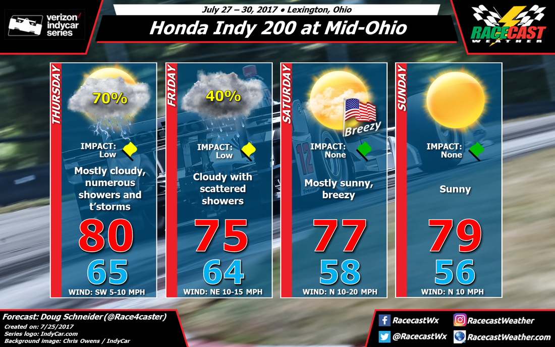
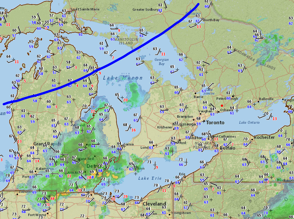
Showers are moving across Ohio today ahead of an approaching surface low pressure system and a cold front. The surface low and front will be southeast of the area by Friday morning, but the upper level trough will lag behind. This is what will keep a chance of showers going at Mid-Ohio on Friday.

I am keeping the chance of rain at 40% today because I do not believe that the entire day will be a washout. There should still be plenty of on-track activity, so I have the Impact Forecast at Low. The most likely time period for rain at the track appears to be in the late morning to early afternoon hours, mainly between 10 am and 3 pm. Looking at the event schedule, the rain may affect IndyCar practice, PWC practice, USF2000 Race 1, and Indy Lights qualifying. But it won't be raining through all those activities - I expect scattered coverage of on/off showers. Thunderstorms are possible, but they should be few and far between. Rain amounts are most likely to be around a tenth of an inch, but up to a quarter inch may be possible if a thunderstorm happens to directly cross over the track. 

Behind the exiting trough, high pressure will be building across the Great Lakes region on Saturday. A brisk northerly flow will keep temperatures relatively cool all day, with highs in the mid 70s. A north wind will be blowing between 10 and 20 mph, with gusts to near 25 mph at times, so pin down your tents and lawn chairs. 

Sunday looks absolutely perfect for racing - highs in the upper 70s with plenty of sunshine. North winds will be a little lighter on Sunday, between 10 and 15 mph. 
Comments

Tuesday forecast update: Honda 200 at Mid-Ohio

7/25/2017

Comments

 
By Doug Schneider - @Race4caster
Picture
I'm putting out an update earlier than planned today because the models have shifted the chance of rain into Friday for Mid-Ohio today. The cold front that will bring numerous showers and thunderstorms on Thursday is still expected to move across the area on Thursday night, but the upper level trough will lag behind it, and keep a chance of showers into Friday. With the models showing the upper trough over Ohio on Friday, this will create some instability that will generate scattered showers. The showers could affect the track at any time of the day. At this time, the showers should be light, with perhaps at tenth of an inch of rain expected. 

The rest of the weekend still looks great, with pleasant temperatures in the 70s and lots of sunshine. Saturday will be breezy behind the departing low pressure system, with gusts around 20 mph at times.
Comments

First forecast for IndyCar and Pirelli World Challenge at Mid-Ohio

7/24/2017

Comments

 
By Doug Schneider - @Race4caster
Picture
The weather looks great at Mid-Ohio this weekend for IndyCar, MRTI, and Pirelli World Challenge racing. While the practice day on Thursday will likely have showers and storms, the rest of the event is expected to stay dry with comfortable temperatures and humidity levels.

A cold front will be approaching Ohio from the northwest on Thursday, There is some uncertainty about the timing details of the storms ahead of the front, so at this point I can't be too specific about it, and there could be showers at any time of the day. The cold front will move through Thursday night, and all the rain will be out of the area by the time cars hit the track on Friday morning. 

Behind the cold front, high pressure will settle into the Great Lakes region while a low pressure system will be east of the Appalachians, and this pattern will remain nearly stationary through the weekend. This will provide a north to northeasterly flow across Ohio that will keep temperatures and humidity levels very comfortable. High temperatures each day will be between 75 and 80, with low temperatures around 60. There will be a steady northeast breeze of 10 to 15 mph each day. 

Unless there is a major change in what the models are showing, which I doubt, my next forecast update will likely be posted on Wednesday. 
Comments

Race Day At The Honda Indy Toronto

7/16/2017

Comments

 
By Scott Martin - ​@RaceWx4You
Picture
You know what... I think we may have mostly dry conditions throughout much of the morning and the early afternoon hours at Exhibition Place in Toronto for race day for the Honda Indy Toronto. Both of the trusty forecast models that I use for short range outlooks are in very close agreement on timing with an approaching front that will be bringing showers to the area.

The good news is that it would appear that the best chances of showers and a possible thunderstorm would be likely starting after the 3PM EST and last through the remainder of the late afternoon and into the evening hours. There will be rain that should be moving by to the north of the event during the morning hours that could bring a light shower, but that shouldn't last very long at all and only be an inconvenience for a few minutes.

When, and if, the rain starts falling during the late afternoon, amounts will be around 1/4 inch or less, so I do not think it will be a washout, and I don't think the rainfall will be intense enough to bring out a red flag during the race. There will be enough to warrant the use of the gray sidewall Firestone Racing rain tires. Afternoon high will be around 81 degrees, and winds will be out of the southwest at 5-15 MPH. 60% chance for rain after 3:00 PM.

Unfortunately, the closest NWS Radar site in Buffalo, NY, has had a major equipment failure, so the software that we use for our site will be unable to do radar. Therefore, I will have updates throughout the afternoon on my Twitter feed @RaceWx4You using RadarScope.
Comments

We Go North Of The Border for The Honda Indy Toronto

7/13/2017

Comments

 
By Scott Martin - ​@RaceWx4You
Picture
I am having to apologize for not putting up a discussion until today for this week's Verizon Indycar Series event in Toronto. Active weather in Alabama has once again kept me pretty busy. Here is the forecast for The Honda Indy Toronto.

Friday looks to be a pretty OK days in Toronto. The trusty forecast models that I am using are in pretty close agreement that rain should not be a factor throughout much of the day at Exhibition Center. I can't entirely rule out a stray shower or two moving through in the afternoon hours, but the risk is rather low at this point. The Canadian weather bureau has a 40% chance of showers and storms, I'm thinking that it will be less than that (about 20%), especially during track activity times. So I'll say mostly cloudy skies with a small risk of an afternoon shower or storm. Afternoon high will be in the lower 70s.

On Saturday, weather will not be an issue at all. It will be a mainly sunny day in Toronto, and quite warm as well. Afternoon high will be up in the lower 80s. Only concern will be getting sunburn. Be sure to pack the shades, hats, and sunscreen.

Sunday is going to be an interesting day at Exhibition Place. Some of the race fans who follow us have been complaining about not having a wet race. Well, there is a decent chance that rain tires will be needed for The Honda Indy Toronto. Both the GFS and NAM-12k are in agreement about a line of rain pushing through at some point during the late morning through the early afternoon hours. Considering that one is showing that the line will be sort of broken in nature, that will keep the chances a little lower in my eyes. With that being said, it will be a cloudy day with a decent risk for showers during the late morning throughout the afternoon hours. The afternoon high will be back down into the mid 70s. I'm pretty close in my thinking for rain chances with the Canadian weather bureau... I'm going 50%, they are going 60%. Either way, if it rains, we're both correct.

I will have radar up and running, but since the race is in Canada, the closest radar is located in Buffalo, I may not have the best geographical information. I am searching for the latest place files for our radar software, so hopefully I can find some that will suffice.
Comments

Forecast update for the Six Hours of Nurburgring

7/12/2017

Comments

 
By Doug Schneider - @Race4caster
Picture
Picture
Not much has changed in my thinking for the forecast for Nurburgring this weekend, but some of the finer details are coming into better focus.

The chance of rain in Friday is expected to be mainly in the late afternoon, probably moving into the area between 3 and 5 pm, with the bulk of it falling between 5 and 7 pm CEST. Rain amounts do not look particularly heavy, perhaps around a tenth of an inch, or between 2 and 3 mm. 

Saturday will have cloudy skies but the rain will be well east of the area by then. With very little sunshine, high temperatures will only be in the upper 60s or lower 20s C. 

Sunday looks like a very nice day, with partly cloudy skies and temperatures warming into the upper 70s (mid 20s C). The slight chance of rain that I had in the previous forecast is gone, as that chance of rain will hold off until Monday.
Comments

First forecast for the Six Hours of Nurburgring

7/10/2017

Comments

 
By Doug Schneider - @Race4caster
Picture
Picture
The opening day of on track action at Nurburgring will likely have some rain. A cold front will be moving across the area in the morning, but a high chance of rain will continue through the day as the upper level trough moves through. There is pretty good model agreement on this general pattern, so I have a high chance of rain at 70%. Rain amounts at this time appear to be between 0.15 and 0.3 inches, or between 4 and 8 mm.

The upper level trough will be east of the area by Saturday, and a weak ridge will build over the area, so I think it will be a dry day with a mix of sun and clouds.

Sunday is probably the biggest question mark in the forecast. The ridge will be weakening through the day, and a weak upper level disturbance is expected to be crossing England and the Netherlands. With weak features like this, the models usually have a harder time figuring out their location and timing. I don't have a lot of confidence on Sunday's forecast, so I have just a slight chance of rain forecast for now with low impact on the race. We'll see how this evolves over the next few days, so check back for updates and follow @Race4caster on Twitter. 
Comments

Friday forecast update: Mobil 1 Sportscar Grand Prix at CTMP

7/7/2017

Comments

 
By Doug Schneider - @Race4caster
Picture
Picture
Forecast in Celsius and km/h. Click to enlarge
Here's a look at the radar and surface observations across Ontario this morning:
Picture
CTMP is located at the red dot northeast of Toronto. I've drawn the approximate position of a cold front with the blue line. There are showers across Michigan and Lake Huron this morning, but I'm not too concerned with these affecting the track - the storms in Michgan will pass south, and the shower over Lake Huron is dissipating. I do expect that as the cold front tracks into southern Ontario late this morning, additional showers and thunderstorms will develop. I expect that there will be scattered storms in the area around CTMP between 2 pm and 6 pm. The chance of one of them hitting the track is about 50%. I have lowered the chance of rain from the previous forecast, as the coverage of showers does not look as great as it did a couple days ago. The Prototype Challenge and WeatherTech practice sessions are the ones most likely to be affected. Rain amounts around a tenth of an inch can be expected if a shower or storm hits the track, with an additional tenth of an inch possible tonight.

The cold front will move through the area tonight, and I expect the rain to exit with it. In the previous forecast, there was a small chance of a shower lingering into Saturday morning as the upper level trough moved through, but the timing of that looks faster today, so I've removed that small rain chance from Saturday morning. It should be a really nice day to be at the track, with cool temperatures in the 70s, low humidity, and a breezy northwest wind.

Unfortunately, Sunday is moving in a wetter direction. Another cold front will be approaching the area, and since it looks to arrive sooner than previously projected by the models, I've had to raise the chance of rain. The 30% chance of rain in the forecast graphic is the chance of rain during the race, which will be held between 12:05 pm and 2:45 pm. There is a higher chance of rain after the race ends. I expect that any rain that might fall during the race will be light, so I have the impact ranked as Low. It could just be some sprinkles that barely even wet the track, like we saw at the end of the Watkins Glen race. Heavier rain may arrive in the late afternoon or evening hours. 
Comments
<<Previous

    Social Feeds


    Instagram


    Authors

    Doug Schneider
    Scott Martin
    Stephen McCoy

    Harris Cooley 


    Partners

    Picture
    Picture
    Picture
    Picture
    Picture

    Categories

    All
    F1
    IGTC
    IMSA
    Indycar
    Le Mans
    MRTI
    NASA
    Outlooks
    Photos
    PWC
    Racecasts
    SCCA
    SRO
    Trans Am
    TUSC
    Verification
    Weather Education
    WEC


    Archives

    March 2023
    February 2023
    January 2023
    December 2022
    November 2022
    October 2022
    September 2022
    August 2022
    July 2022
    June 2022
    May 2022
    April 2022
    March 2022
    February 2022
    January 2022
    December 2021
    November 2021
    October 2021
    September 2021
    August 2021
    July 2021
    June 2021
    May 2021
    April 2021
    March 2021
    January 2021
    December 2020
    November 2020
    October 2020
    September 2020
    August 2020
    July 2020
    June 2020
    March 2020
    January 2020
    December 2019
    November 2019
    October 2019
    September 2019
    August 2019
    July 2019
    June 2019
    May 2019
    April 2019
    March 2019
    February 2019
    January 2019
    December 2018
    November 2018
    October 2018
    September 2018
    August 2018
    July 2018
    June 2018
    May 2018
    April 2018
    March 2018
    February 2018
    January 2018
    December 2017
    November 2017
    October 2017
    September 2017
    August 2017
    July 2017
    June 2017
    May 2017
    April 2017
    March 2017
    February 2017
    January 2017
    December 2016
    November 2016
    October 2016
    September 2016
    August 2016
    July 2016
    June 2016
    May 2016
    April 2016
    March 2016
    February 2016
    January 2016
    December 2015
    November 2015
    October 2015
    September 2015
    August 2015
    July 2015
    June 2015
    May 2015
    April 2015
    March 2015
    February 2015
    January 2015
    December 2014
    November 2014
    October 2014
    September 2014


Powered by Create your own unique website with customizable templates.