Racecast Weather - Your Source for Race Weather Information
  • Home
  • Racecasts
  • 2023 Schedule
  • Services
  • Contact
  • Bios
  • Links

Friday forecast update: Pirelli World Challenge at VIR

4/28/2017

Comments

 
By Doug Schneider - @Race4caster
Picture
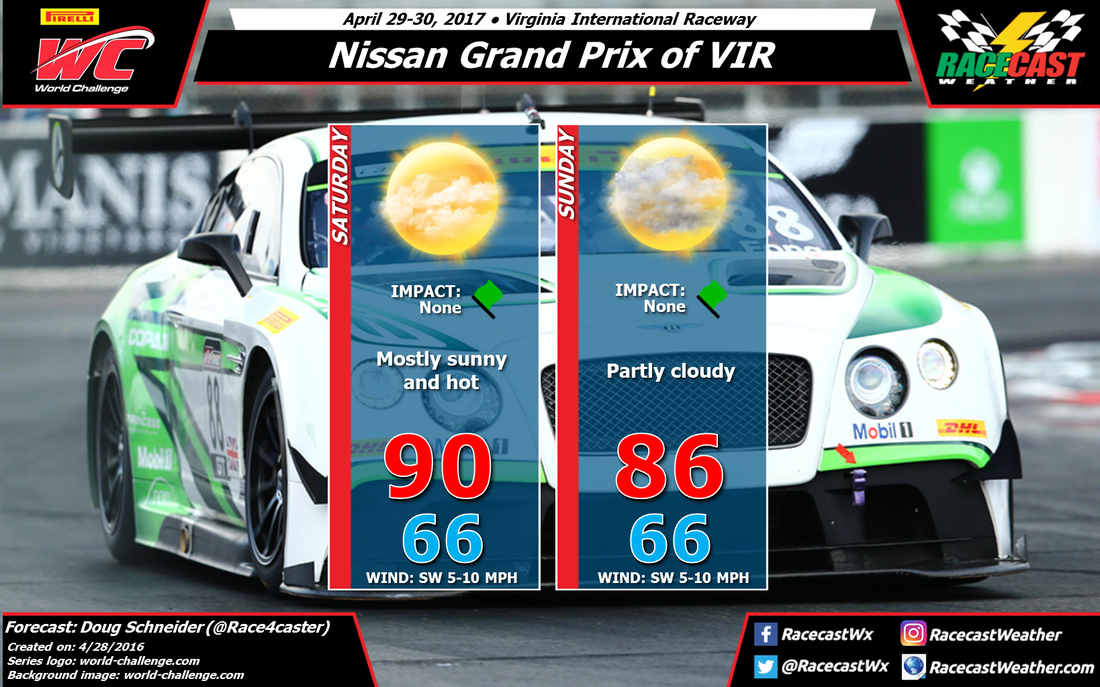
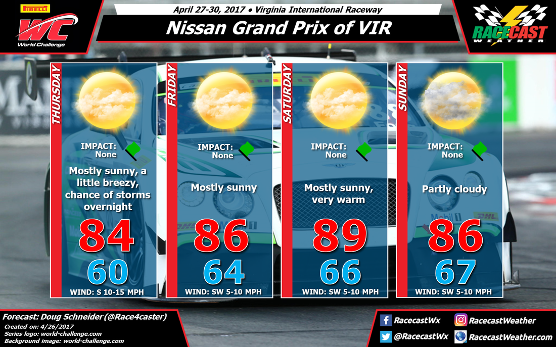
Not much change to the forecast  for VIR this weekend. Partly to mostly sunny skies are expected both Saturday and Sunday as high pressure will continue to dominate the weather pattern across the Southeast. Temperatures will reach their hottest on Saturday, with a high near 90 degrees. More cloud cover is expected on Sunday, which should give slightly cooler high temperatures, but still very warm, in the mid 80s.

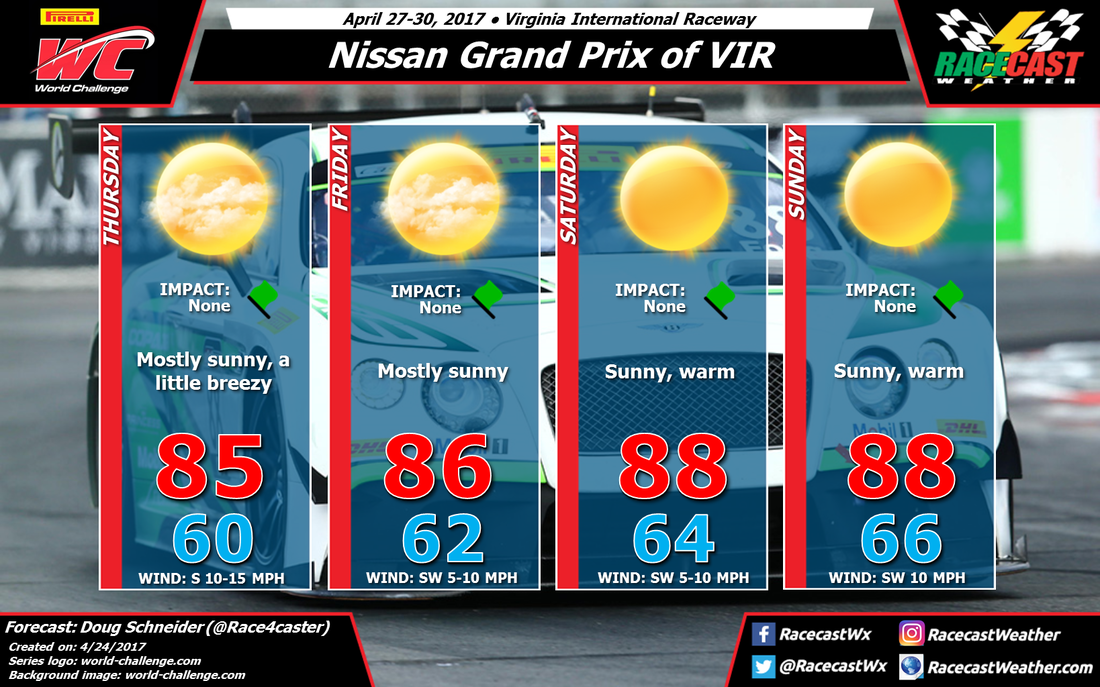
In my last forecast, I mentioned some uncertainty about showers developing on Sunday afternoon, but I'm feeling more confident that the activities at the track will remain dry. The final TC race ends at 3:20 pm, and if showers are able to develop around the area, it will happen after the race ends. So I'm keeping the forecast dry with no impacts. 

If you're at the track this weekend, don't forget to use the sunscreen and to drink plenty of water.
Comments

Update for Verizon Indycar Series #DesertDiamondPGP

4/28/2017

Comments

 
By Scott Martin - ​@RaceWx4You
Picture
Not much change at all to the forecast for tonight and tomorrow night out in the desert of Phoenix, Arizona. Afternoon highs for Friday will be just a few degrees cooler than first thought, but 87 degrees for the high is still rather warm. The big story will be the winds today... as winds will be averaging around 20-25 MPH out of the west for much of the remainder of the day, and gusting as high as 40 MPH at times. Those wind gusts are expected to be the highest during the practice session tonight at 4PM through 6PM. There could be some blowing dust at times as well, which could hamper visibility out on the track, along with the handling of the cars. Wind gusts could still be as high as 35 MPH when the series hits the track for qualifying at 8PM. Temperatures will be in the mid 70s at that time.

Cooler temperatures and a little less wind will be the big story for Saturday night for the running of the Desert Diamond West Valley Phoenix Grand Prix. The afternoon high will only reach around 82 degrees, but will drop down to around 79 degrees at 6PM. Winds will be out of the north-northwest, but shifting out of the west-northwest at 10-15 MPH at the green flag, with a few gusts up to 25 MPH possible. The temperatures should drop to around 71-73 degrees by the time the checkered flag flies. Dust should not be an issue.
Comments

Forecast for The Verizon Indycar Series in Phoenix

4/26/2017

Comments

 
By Scott Martin - ​@RaceWx4You
Picture
Well just a few short days removed from Barber Motorsports Park in Birmingham, we now shift our focus to the Desert Diamond West Valley Phoenix Grand Prix for the Verizon Indycar Series. The good news is that we will not have to be dealing with any rain chances. The bad news, high winds may bring blowing dust into the forecast for Friday.

On Friday, the skies will be sunny and temperatures will be warm, with highs up into the upper 80s, around 89 degrees. The main story is that it will be breezy throughout the day. Winds will start off out of the southwest, but will quickly shift to out of the west and will increase during the afternoon hours into the 20-25 MPH range, with gusts up to 40 MPH possible. Those winds are expected to be the highest during the practice session that is scheduled to take place from 4PM-6PM. With the possibility of blowing dust and the strong winds, that will make those machines hard to hold on to. Conditions improve slightly at 8PM for qualifying, but wind gusts could still reach as high as 35 MPH. Temperatures will be in the upper 70s for qualifying, starting off near 77 degrees.

Saturday evening seems to be a much calmer day as far as the wind, but the one thing you will notice is the cooler temperatures for this time of the year at Phoenix International Raceway. Skies will be clear, and temperatures at the 6PM hour will be around 80 degrees and dropping to near 71 degrees by the checkered flag. Winds will be out of the northeast at 5-15 MPH.
Comments

Wednesday forecast update: Pirelli World Challenge at VIR

4/26/2017

Comments

 
By Doug Schneider
Picture
The forecast continues to look good for uninterrupted racing action at VIR this weekend, but that comes with some caveats as my confidence in a completely dry weekend is getting lower. 

On Thursday, a cold front and an upper level trough will be approaching from the west. The good news is that storms along the front will be weakening after they cross the mountains. There is still a chance of a few storms making it to VIR Thursday evening, but the timing of any rain chance appears to be after the end of the day's on-track activities. I think the earliest chance of showers to begin will be between 7 and 9 pm, and the F1600 practice session is scheduled to end at 6 pm. I'd put the chance of showers and storms on Thursday night at 30%. 

On Friday, high pressure will be located off the NC Outer Banks, and it will be strengthening and building westward through Saturday. This will provide mostly sunny skies, dry weather, and a warm southwest flow that will help temperatures rise into the upper 80s on Saturday. Humidity levels will be rising through the weekend as well, but it won't be oppressively humid. You'll want to be prepared with sunscreen and plenty of water if you're going to the track.

The high pressure ridge will begin to give way a little on Sunday as a low pressure system tracks across the Midwest states. Based on the current timing of the models, most of the rain with this system should remain well west of VIR on Sunday, and hold off until Monday. However, some models are indicating that with the high pressure ridge weakening, there may be enough instability for some afternoon storms to pop up around the Piedmont. I am keeping the forecast dry for Sunday because I think the chances of storms at the track is still too low to mention. But I'm not feeling very confident about this, and this will bear watching over the next few days. There will be a little more cloud cover spreading over the track, which will take a few degrees off the high temperatures compared to Saturday.
Comments

Forecast for Pirelli World Challenge at VIR

4/24/2017

Comments

 
By Doug Schneider
Picture
Pirelli World Challenge returns to beautiful Virginia International Raceway after a long hiatus, and the weather looks like it will cooperate to make for a great weekend. With over 100 cars in action, it should be an exciting and action-packed event. 

The weather pattern for the middle of the week across the United States will feature a low pressure trough and cold front over the Central and Southern Plains that will be lifting northeast through Thursday. The northeastward track of the system will mean that its greatest impact will be felt to the north of VIR, mainly across the Ohio Valley and Central Appalachians. The mountains of western North Carolina will probably have a weakening effect on the tail end of it as well. Even if the system can survive the mountain crossing enough to develop some storms in the Piedmont, the timing favors an arrival after the day's testing sessions are over. So I think the most likely scenario is that VIR remains dry on Thursday. 

Once this system passes by, an area of high pressure off the North Carolina coast will be gaining strength and extending across the Southeast. This will provide a warm southwest flow that will bring sunny skies and daytime temperatures into the mid and upper 80s for Friday through Sunday. The only impacts that I can see right now will be for the potential for sunburn and dehydration, so don't forget to apply the sunscreen and drink plenty of water while you're at the track. 
Comments

Raceday Forecast for Honda Indy Grand Prix of Alabama

4/23/2017

Comments

 
By Scott Martin - ​@RaceWx4You
Picture
Sunday - Race Day Weather
We will start off the day with some lingering showers after the passage of the front, but these should move out of the area before 10AM. Skies will stay generally cloudy throughout the remainder of the day, and we could have a stray light shower or a few sprinkles during the afternoon. I do not believe that these showers will be heavy enough to disrupt the on-track activities. Rain tires may be needed during the race, but the odds of that happening will be very low. Sunday will be much cooler, and winds will be out of the northwest at 5-10 MPH. The afternoon high will be around 64 degrees. The chance of rain at the track during the morning will be 80%, but dropping to about 20% through the rest of the day.
Comments

Saturday AM Update to HIGPA Forecast

4/22/2017

Comments

 
By Scott Martin - ​@RaceWx4You
Picture
​Saturday's Racing Weather...
Much of the day at Barber Motorsports Park should remain dry, which is the good news, but rain chances will have to be increased for earlier in the afternoon at the track. A mass of shower and storms that is located over the northwest corner of the state will be slowly pushing across Central Alabama, and will be diminishing some as it makes its way eastward. We may have scattered showers and storms approaching the track at or just after the noon hour, but this will not be the cold front that will be bringing the line of possibly strong storms to the area. Those storms should not arrive at the track until after the 6PM hour. We'll have mostly clear skies to start, but we'll have increasing clouds as the first batch of rain approaches, and will be mostly cloudy afterwords. The afternoon high will be around 82. Winds will be out of the southwest at 6-12 MPH. The odds for rain at the track during the afternoon will be about 1 in 3, or 30%.

For the fans and teams that are staying overnight at the track, the line of storms that will be pushing through this evening could have some strong to marginally severe storms embedded in the line. The main threats will be from gusty winds and some hail, and even though the tornado threat is very low, it is still not zero. Be sure to have a way to receive weather alerts either on a NOAA Weather Radio or on a smart phone.

Sunday - Race Day Weather
We will start off the day with some lingering showers after the passage of the front, but these should move out of the area before 10AM. Skies will stay generally cloudy throughout the remainder of the day, and we could have a stray light shower or a few sprinkles during the afternoon. I do not believe that these showers will be heavy enough to disrupt the on-track activities. Rain tires may be needed during the race, but the odds of that happening will be very low. Sunday will be much cooler, and winds will be out of the northwest at 5-10 MPH. The afternoon high will be around 65 degrees. The chance of rain at the track during the morning will be 40%, but dropping to about 20% through the rest of the day.
Comments

Forecast For The Honda Indy Grand Prix of Alabama... From The Track

4/21/2017

Comments

 
By Scott Martin - ​@RaceWx4You
Picture
​TODAY AT THE TRACK
The day has started off beautiful out here at the Barber Motorsports Park, with clear skies and temperatures in the mid 60s at a little after the 8AM hour. The temperatures will warm nicely today, and will be very warm today by the time we reach the afternoon high of 85 degrees. We will have showers and thunderstorms off to the north of the track and most will stay away. We may have a stray shower venture this far south to the track, but the chance of that happening is less than 10%... almost not even worth mentioning. Winds will be out of the southwest at 5-10 MPH.

A SPENDID SATURDAY SHAPING UP AFTER ALL
Great news is that the line of thunderstorms with an associated cold front that will be moving through the area will not make it into the area until well after the track activity has completed for the day. Afternoon high should top out around 83 degrees under mostly sunny skies. Once again, we may have an isolated shower or storm develop out ahead of the front with the heating of the day, but the odds of any rain at the track before the line moves in will be around 1 in 5. Winds throughout the day will be out of the southwest at 5-15 MPH.

MUCH COOLER AND DRY FOR SUNDAY
After the front moves through on Saturday night, you will be able to tell a big difference in temperatures for race day. Skies will be cloudy throughout the day, and winds will be out of the northwest at 5-10 MPH. Morning temperatures will start off in the upper 50s, and only climb into the mid 60s for the afternoon high (around 65). We may have a few sprinkles pass through with wrap around moisture on the back side of the low, but on-track activity should not be affected.

I'll be out at the track giving updates throughout the weekend. I will also be making a couple of interviews on IndyCar Radio throughout the weekend. Listen for me during the morning practice sessions for the Verizon Indycar Series today and tomorrow morning, and during the final warmup before the race on Sunday morning. My updates will be on my Twitter feed, along with our social media feeds.
Comments
<<Previous

    Social Feeds


    Instagram


    Authors

    Doug Schneider
    Scott Martin
    Stephen McCoy

    Harris Cooley 


    Partners

    Picture
    Picture
    Picture
    Picture
    Picture

    Categories

    All
    F1
    IGTC
    IMSA
    Indycar
    Le Mans
    MRTI
    NASA
    Outlooks
    Photos
    PWC
    Racecasts
    SCCA
    SRO
    Trans Am
    TUSC
    Verification
    Weather Education
    WEC


    Archives

    March 2023
    February 2023
    January 2023
    December 2022
    November 2022
    October 2022
    September 2022
    August 2022
    July 2022
    June 2022
    May 2022
    April 2022
    March 2022
    February 2022
    January 2022
    December 2021
    November 2021
    October 2021
    September 2021
    August 2021
    July 2021
    June 2021
    May 2021
    April 2021
    March 2021
    January 2021
    December 2020
    November 2020
    October 2020
    September 2020
    August 2020
    July 2020
    June 2020
    March 2020
    January 2020
    December 2019
    November 2019
    October 2019
    September 2019
    August 2019
    July 2019
    June 2019
    May 2019
    April 2019
    March 2019
    February 2019
    January 2019
    December 2018
    November 2018
    October 2018
    September 2018
    August 2018
    July 2018
    June 2018
    May 2018
    April 2018
    March 2018
    February 2018
    January 2018
    December 2017
    November 2017
    October 2017
    September 2017
    August 2017
    July 2017
    June 2017
    May 2017
    April 2017
    March 2017
    February 2017
    January 2017
    December 2016
    November 2016
    October 2016
    September 2016
    August 2016
    July 2016
    June 2016
    May 2016
    April 2016
    March 2016
    February 2016
    January 2016
    December 2015
    November 2015
    October 2015
    September 2015
    August 2015
    July 2015
    June 2015
    May 2015
    April 2015
    March 2015
    February 2015
    January 2015
    December 2014
    November 2014
    October 2014
    September 2014


Powered by Create your own unique website with customizable templates.