|
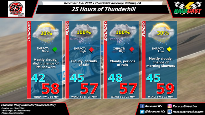
By Doug Schneider There's no good news to report today about the weather forecast at Thunderhill Raceway this weekend. A deep and slow-moving low pressure system will be crossing Northern California, bringing periods of rain and breezy conditions from Thursday night through Saturday night. The only change change to the forecast worth mentioning is that the models are showing this system moving slightly slower than before, and to account for that, I have added a chance of rain to Sunday morning. So while the vast majority of the 25 Hours will be run in the rain, the final stages of the race, possibly the final 3-6 hours, may be rain-free. Through the event, I expect that rainfall amounts will likely be between 1 and 2 inches. Wind will also be a factor on Friday and Saturday, with sustained winds from the south to southeast at 15 to 25 mph, with gusts between 30 and 40 mph at times.
By Doug Schneider I wish I could bring better news of a dry and sunny forecast for the 25 Hours of Thunderhill, but unfortunately, it looks like it will be a very wet weekend in Willows, California.
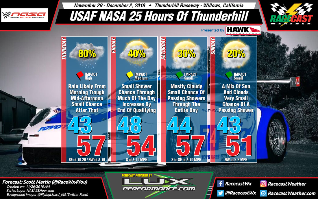
A strong low pressure system will be tracking west across the Pacific through the week, and arrive in northern California just in time for the on-track action. As teams set up and start to practice on Thursday, clouds will be increasing but most of the day will remain dry, with just a slight chance of rain possible late in the day. The chance of rain will be increasing Thursday night, and by Friday there will be periods of on/off rain as a flow of deep moisture spreads into the area ahead of the low pressure system. This system will be slow-moving, so rain will continue to spread across the area through Friday night and Saturday. There will also be a good southerly breeze on Friday and Saturday, with sustained winds between 15 and 25 mph, with higher gusts. The total amount of rainfall through Saturday could be between 1 and 2 inches. However, it's still a long way out in the forecast, so the forecast rain amounts will come into better focus as we get closer to the weekend. Rain is expected to start tapering off on Saturday night. This far out, timing is uncertain, but right now I expect that by daybreak Sunday morning, all the rain should be gone. Clouds will start to decrease as drier air moves in, and there may be a mix of sun and clouds by the checkered flag. Check back for updates to the forecast through the week. By Scott Martin. Thursday looks to be a pretty grey and possibly wet throughout the day. Rain will be likely during the morning and much of the afternoon, but those rain chances drop of for the late afternoon through the evening hours while skies become partly cloudy. Temperatures will be in the lower 50s at 7:00 am, warming into the upper 50s for the daytime high, then dropping into the lower 40s at midnight. Rain chances will be around 80% for the morning and into the early afternoon hours, then dropping to around 30% for the remainder of the on-track activity. Winds will start off out of the southeast at 10-20 MPH but will shift out of the northwest by late afternoon at 5-10 MPH.
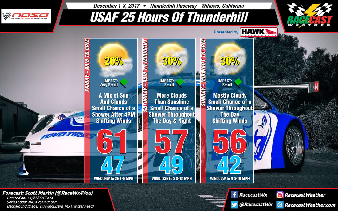
Friday looks a little better than Thursday, but we'll continue to have a small chance of showers throughout the day. Skies will be partly to mostly cloudy with temperatures at 9:30 am in the upper 40s, topping out in the mid-50s for the afternoon high, and dropping into the lower 50s by the end of the qualifying session at 5:45pm. Rain chances will be around 20% for much of the on-track activity, but increasing to near 40% before the end of qualifying. Winds will be out of the south at 5-10 MPH. Mostly cloudy skies and a small chance of showers will continue throughout the day on Saturday as the race is scheduled to start just after 11:00 am. Rain chances will be around 30% from the pre-grid at 9:30 am through mid-afternoon, then drops off a little to around 20% for the rest of the afternoon through midnight. Temperatures at the green flag will be in the lower 50s, topping out in the upper 50s for the high, then dropping into the mid-40s by midnight. Winds will be out of the south to southeast at 5-10 MPH. While we should be mainly dry with partly cloudy skies during the early morning hours on Sunday through the checkered flag at noon and the awards ceremony to follow up during the afternoon, there still remains a very small chance of showers (less than 20%). Temperatures will remain dropping from the mid-40s at midnight to the lower 40s by 3:00 am, but they will begin to climb steadily into the lower 50s by 12:00 pm. Winds will be out of the northwest at 2-8 MPH. By Scott Martin - @RaceWx4You Looks like the forecast is holding pretty close to what I posted yesterday, so here is a breakdown of what you can expect through the start of the day today through the end of the race at noon on Sunday...
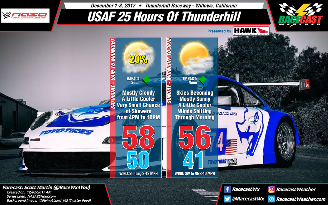
SATURDAY 9AM - Mostly cloudy 50ºF. Winds W 2-5 MPH. 11AM - Mostly Cloudy 54ºF. Winds ESE 2-5 MPH. (Green Flag) 1PM - Mostly Cloudy 58ºF. Winds SE 5-10 MPH. 4PM - Mostly Cloudy, 10% Rain Chance. 56ºF. Winds SSE 6-12 MPH. 7PM - Mostly Cloudy, 20% Rain Chance. 53ºF. Winds S 5-10 MPH. 10PM - Mostly Cloudy 50ºF. Winds SW 5-10 MPH. SUNDAY 12AM - Mostly Cloudy 48ºF. Winds SW 5-10 MPH. 3AM - Mostly Cloudy 46ºF. Winds WSW 5-10 MPH. 6AM - Mostly Cloudy 41ºF. Winds WSW 5-10 MPH. 9AM - Partly Cloudy 45ºF. Winds SW 5-10 MPH. 12PM - Mostly Sunny 53ºF. Winds NE 3-7 MPH. (Checkered Flag) For the remainder of the daylight hours on Sunday for post-race activities, skies will continue to be mostly sunny and temperatures will rise to around 56 for the high, before steadily dropping into the upper 40s by 6PM. Radar is up and running on our website (if using a mobile device, view site as desktop for best performance). Good luck to all of the teams and officials, and have a great Saturday! By Scott Martin - @RaceWx4You The forecast continues to improve for the USAF 25 Hours of Thunderhill as rain chances continue to drop and skies appear to be more sunny than first thought.
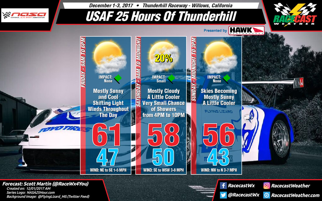
For the rest of the day today, skies will be mostly sunny and the high will reach around 61 degrees. Temperatures will drop into the upper 50s for the start of qualifying and gradually fall into the mid-50s by the end. Late tonight, clouds will be on the increase but will remain dry through the end of the day. Saturday will start off with temperatures around 50 degrees at 9AM and gradually warming to around 55 degrees at the drop of the green flag. Skies will be mostly cloudy throughout the entire day, but we will have a very small chance of a passing shower or two starting late in the afternoon and lasting through the late evening hours. Rain chances will only be around 20%. All rain activity should be out of the area by 10PM. The daytime high will top out around 58 degrees, steadily dropping to around 51 degrees at 8PM, and bottoming out around 43 degrees at 6AM on Sunday morning. On Sunday, skies will begin to clear out and will be mostly sunny by late morning. 9AM temperature will be around 45 degrees and will warm to around 53 degrees at the drop of the checkered flag. Radar will be up and running in a few minutes. Have a great Friday! By Scott Martin - @RaceWx4You One thing that can either keep you very interested or make you very frustrated is a forecast that continuously changes. Fortunately, ever-changing weather keeps my job interesting. So far, looking over the model data coming in for this weekend at Thunderhill Raceway Park, conditions have improved from my Monday morning forecast to today's.
Friday looks to be a brilliant day out at the track with a good bit of sunshine throughout the day with only a few clouds. Temperatures will start off the track day around 49ºF at 9:00 AM, and will warm up to around 63ºF by the mid-afternoon hours. No rain is expected, and winds will be shifting from the northwest at the start to out of the south by qualifying time. Models have come into better agreement with the system moving down into the area from the Gulf of Alaska on Saturday, keeping the better rain chances well north of the track. Unfortunately, there will be just enough moisture close by to merit a very small chance of showers during the entire racing day, when the best chances of rain activity occurring in the late evening hours on Saturday to the pre-dawn hours on Sunday. The temperatures will be around 48ºF at 9:00 AM then warming to around 53ºF at the drop of the green flag. The daytime high will be around 60ºF at the 3:00 PM hour and steadily dropping to near 50ºF at 8:00 PM. Any rain activity should diminish before the 4:00 AM hour on Sunday morning and the skies will begin to clear somewhat. The morning low of around 41ºF will occur close to the 6:00 AM - 7:00 AM time period. Soon after, you will notice the winds begin to pick up in speed out of the north-northwest from 5 MPH up to 15 MPH by the late morning hours. At the checkered flag, the temperatures should be around 57ºF. The daytime high of around 60ºF will be reached during the post-race activities. I'll have radar up and running starting on Friday morning on the website. Be sure to follow our main Twitter feed @RacecastWx as we will be using it as our one-stop place for forecasts and updates on Twitter. We'll continue to have our personal accounts as well, but we'll only use those to retweet our forecast and for personal use. As always, our forecasts will still be featured on our Facebook page along with our Instagram account. Thank you and have a great Wednesday. By Scott Martin - @RaceWx4You My first look forecast is out for the USAF 25 Hours of Thunderhill, and we have a little rainfall trying to sneak in. It's too early to give exact amounts and timing on the projected showers, but here is what we know at this point.
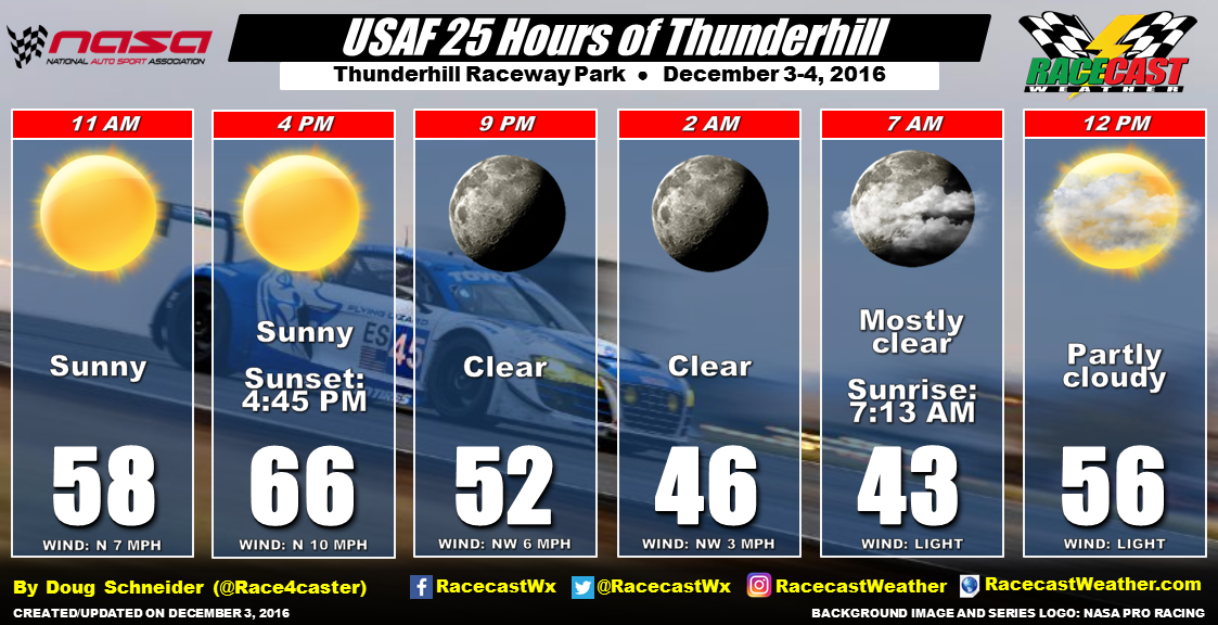
A system will be moving out of the Gulf of Alaska and will make its way into the area starting on Friday and will hang around throughout the weekend. Rain chances will start on Friday afternoon just before qualifying and will slightly increase throughout the overnight and pre-dawn hours on Saturday. Those chances will diminish a little throughout much of the day on Saturday before slightly rising for the late afternoon through the pre-dawn hours on Sunday morning. Unfortunately, a very small chance of a shower or two will remain throughout the end of the event on Sunday and afterwords for the awards ceremony. For the graphic, the temperatures shown are the daytime highs on each day, with 9AM temperatures on Friday and Saturday, and the early morning low temperature on Sunday. When the event gets closer, I'll have a better breakdown with temperatures by the hour on raceday. I'll have radar up and running starting on Friday morning on the website. Be sure to follow our main Twitter feed @RacecastWx as we will be using it as our one-stop place for forecasts and updates on Twitter. We'll continue to have our personal accounts as well, but we'll only use those to retweet our forecast and for personal use. As always, our forecasts will still be featured on our Facebook page along with our Instagram account. Thank you and have a great Monday. By Doug Schneider The 25 Hours of Thunderhill will have great weather from start to finish. Sunny skies and high temperatures in the mid 60s can be expected today. Nearly 60% of the race is run in the dark, as sunset is at 4:45 and sunrise is about 14 and a half hours later. There will be a few more clouds at the end of the race, but no rain like last year.
I'm looking forward to listening to the race on Endurance Radio. Be sure to tune in at 2 pm EST or 11 am PST. |
Social Feeds
Authors
Doug Schneider Partners
Categories
All
Archives
December 2023
|

