Racecast Weather - Your Source for Race Weather Information
  • Home
  • Racecasts
  • 2022 Schedule
  • Services
  • Radar
  • Contact
  • Bios
  • Links

Tuesday forecast update: Detroit Belle Isle Grand Prix

5/31/2016

Comments

 
By Doug Schneider
With today's forecast update, the chance of rain on Sunday is looking a little better. While IMSA’s racing should be dry, there’s a chance that Trans Am and IndyCar could have some rain impact their Sunday races.
A cold front will pass through the Detroit area early Thursday morning, and there’s just a small chance of showers after sunrise as teams set up at Belle Isle. Most of the day will be dry, with decreasing clouds. Temperatures will be a little cooler for Friday behind the front, with drier air and a northwest wind providing mostly sunny skies.
​

Another low pressure system will be approaching from the west over the weekend, which will shift winds back to the south and bring more moisture into the area. Temperatures will be trending warmer for Saturday, with a little more cloud cover. As the low gets closer, the chance of rain will increase for Sunday. Right now, it looks like it is a 50/50 chance of having rain at the track on Sunday.

Unless there's a significant change needed, I plan on posting the next update on Thursday. Follow our social media feeds on the right for the latest updates.
Comments

Forecast for the Detroit Belle Isle Grand Prix

5/29/2016

Comments

 
By Doug Schneider
A cold front is expected to move through the Detroit area on Thursday, which will bring a good chance of showers and thunderstorms. It is possible that the storms with the front will move through Wednesday night, so the timing is a little uncertain, so I'm putting a chance of rain in for load-in day on Thursday. Fortunately,, there is no on-track action scheduled that day.

An upper level low pressure system will be sitting over Ontario for the rest of the weekend. This will bring cooler temperatures on Friday and Saturday, with highs in the lower 70s.  

Another upper level disturbance rotating around the low will bring the possibility of some showers and storms on Sunday. With the timing still uncertain this far out, I only have a 30% chance of rain. I'll be keeping an eye on this for the next few days. 
Comments

Race day weather: 100th Indianapolis 500

5/28/2016

Comments

 
By Doug Schneider
Picture
It has been difficult to think about the weather today due to the terrible accident today in PWC practice at Lime Rock Park, as our thoughts and prayers are with Andrew Palmer and Jorge de la Torre. 

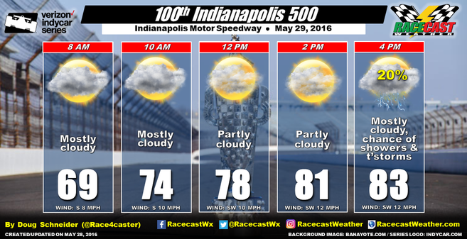
The past few days, I've been optimistic about getting the entire Indy 500 in without rain. I'm feeling more and more confident about that happening with the latest data this morning. Most of the moisture that has been over the Midwest and Indiana the past few days will be shifting east, with drier air aloft moving in from the west tonight. With this dry air above the surface, it will be difficult for storms to develop tomorrow afternoon. There will be a cold front approaching the area, which will result in some isolated to scattered storms developing in Indiana, but I expect that they will hold off until after the race ends. I'd put the chance of getting the entire race done with no rain delays at 90%. The day will likely start off with some clouds, but these clouds should gradually decrease through the morning, leaving partly cloudy skies by the start of the race. Temperatures will reach the lower 80s, and winds will be between 8 and 12 mph, generally from the south-southwest. 

Enjoy the race, it's going to be epic.
Comments

Friday Forecast Check: PWC at Lime Rock Park

5/27/2016

Comments

 
By Scott Martin
Picture
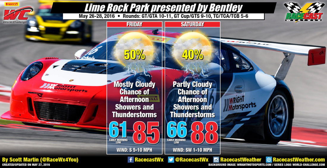
Today will be a warm day at the track, and with dewpoints rising up into the 60s today, the mid 80s forecasted for today's highs will feel uncomfortable to some. There is a boundary located near the region and is expected to lift to the northeast as a warm front. Isolated convective showers and thunderstorms will form across the area this afternoon, but coverage could be limited due to weak forcing. As the day progresses, humidity levels rise and so will the chance for showers and thunderstorms. Rainfall should not last too long, and amounts should average around a tenth of an inch.

On Saturday, the warm front will stay west of the area, but a cold front starts to move into northern New York and northern New England. A chance for convective showers and thunderstorms to develop over the area during the afternoon and evening hours. Also, with highs reaching the upper 80s, dewpoints will reach the upper 60s to near 70, and this will mean that the heat index will be in the 90s. Once ahain, rainfall shouldn't last too long, and amounts should average around a tenth of an inch.

Stay hydrated and in the shade when possible. Also remember that when you hear thunder, you are close enough to be struck by lightning. So when thunder roars, go indoors. Radar will be up and running on the Pirelli World Challenge website. Just click the link posted beneath the Racecast Weather logo. I'll also have updates on our Twitter feed.
Comments

Thursday forecast update: 100th Indianapolis 500

5/26/2016

Comments

 
By Doug Schneider
Picture
Unfortunately, showers and thunderstorms washed out qualifying for the Indy Lights Freedom 100 today. The weather pattern for tomorrow and Saturday looks much the same as it did today, so the chances of seeing additional showers and thunderstorms on Carb Day and Legends Day will be 50/50 or higher. In a moist air mass like this one, it is difficult to pin down the timing of showers in advance. Showers are possible at any time of the day Friday and Saturday, so if you're at IMS or at Lucas Oil Raceway for the Carb Night Classic, you should stay weather-aware. You can click the IMS Radar link at the top of the page to see where storms are in relation to IMS, along with lightning strikes. The range rings that are displayed mark 8, 12, and 16 miles from the Speedway. Remember - if you can hear thunder, you are close enough to be struck by lightning. Have a plan in advance of where to seek shelter, and move there as soon as you hear thunder. Remain sheltered until 30 minutes after the last thunder is heard.

Sunday continues to look more promising for racing as a ridge of high pressure will develop over the southeast, which will cut off the flow of moisture from the Gulf of Mexico. Still, there will be a small chance of showers and thunderstorms due to an upper level disturbance that will move through. The key will be the timing. It looks like the atmosphere will be capped for most of the day, which means that showers will not be able to develop until this cap breaks. Forecasting the timing of this is always tricky, but right now, I expect that storms will hold off around the Speedway until late in the afternoon (around 3 pm or later). I'm optimistic that the race will be done before any storms develop. The 30% chance of rain in the forecast is for the chance of rain before 4 pm. I'd put the chance of rain after 4 pm closer to 50%. Even if the storms hold off until after the race, they could add to the traffic problems leaving the Speedway. 
Comments

Wednesday Forecast for PWC at Lime Rock Park

5/25/2016

Comments

 
By Scott Martin
Picture
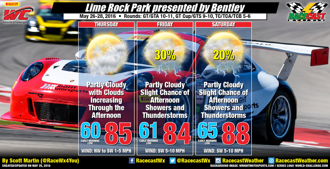
A surface boundary is expected to stall over eastern New York and south-central New England, and it will start to lift to the north as a warm front during tomorrow afternoon. Clouds and moisture levels will be on the increase, and rain chances will start to increase during the late evening and overnight hours. You will notice the dewpoints and humidity levels will be higher, and so will the atmosphere. With the higher dewpoints will bring a chance of convective afternoon showers and thunderstorms. Storms will not last too terribly long, and rain amounts will be around 0.10 of an inch or less.

Saturday, highs will be warmer and the risk for thunderstorms will be a little less. A CAP in the mid-levels is expected to be established and it will be hard for storms to develop. If they do develop, rainfall amounts could be locally heavy on Saturday afternoon.

​Radar will be up and running on the Pirelli World Challenge website. Just click the link posted beneath the Racecast Weather logo. I'll also have updates on our Twitter feed.
Comments

Tuesday forecast update and video weather briefing for the 100th Indianapolis 500

5/24/2016

Comments

 
By Doug Schneider

Watch the video weather briefing for my latest thoughts on the weather for the Indianapolis 500.
Picture
Comments

Forecast for the 100th Indianapolis 500

5/22/2016

Comments

 
By Doug Schneider
Picture
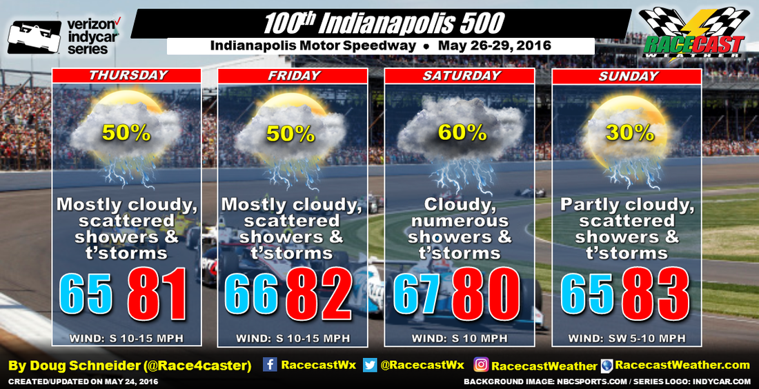
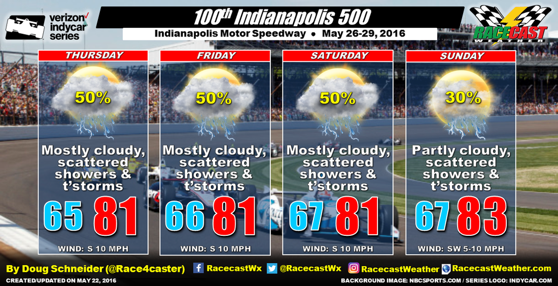
It's almost time for the 100th edition of the Greatest Spectacle in Racing. While we all hope that the weather won't interfere with the events, but unfortunately, the weather pattern later this week looks like a potentially wet one. 

The pattern across the eastern half of the United States will feature high pressure off the Southeast coast and low pressure over the Plains. This will produce a southerly flow of moisture from the Gulf of Mexico toward Indiana. The abundant moisture along with afternoon heating will generate scattered showers and thunderstorms. This pattern is expected to persist and not change very much through race weekend, so there will be a chance of showers and thunderstorms at the Speedway everyday. I've been monitoring the weather models over the past few days, and they generally agree on this pattern, and have been consistent from one model run to the next. So I have medium confidence in this forecast.

There is some good news in this forecast - there isn't a strong low pressure system or front tracking across the area that will make any particular day a complete washout. Pinning down a specific time that is favored for rain is difficult this far out, but I think that the afternoons will be the favored time for showers due to heating creating some instability. It looks more like a passing shower or thunderstorm will be possible at times that will wet the Speedway and move on.

​Another piece of good news is that Sunday appears to have the lowest chances of showers, as the high pressure area off the Southeast coast is expected to build a little toward the west. This may push the Gulf moisture westward and keep most of the showers west of Indiana, so I have a lower rain chance on Sunday than the other days. With the pattern changing very little, high temperatures are expected to be in the lower 80s each day. Winds will be from the south to southwest around 10 mph each day.

I plan on making a video briefing for the forecast update on Tuesday. 
Comments
<<Previous

    Social Feeds


    Instagram


    Authors

    Doug Schneider
    Scott Martin
    Stephen McCoy

    Harris Cooley 


    Partners

    Picture
    Picture
    Picture
    Picture
    Picture
    Picture

    Categories

    All
    F1
    IGTC
    IMSA
    Indycar
    Le Mans
    MRTI
    NASA
    Outlooks
    Photos
    PWC
    Racecasts
    SCCA
    SRO
    Trans Am
    TUSC
    Verification
    Weather Education
    WEC


    Archives

    May 2022
    April 2022
    March 2022
    February 2022
    January 2022
    December 2021
    November 2021
    October 2021
    September 2021
    August 2021
    July 2021
    June 2021
    May 2021
    April 2021
    March 2021
    January 2021
    December 2020
    November 2020
    October 2020
    September 2020
    August 2020
    July 2020
    June 2020
    March 2020
    January 2020
    December 2019
    November 2019
    October 2019
    September 2019
    August 2019
    July 2019
    June 2019
    May 2019
    April 2019
    March 2019
    February 2019
    January 2019
    December 2018
    November 2018
    October 2018
    September 2018
    August 2018
    July 2018
    June 2018
    May 2018
    April 2018
    March 2018
    February 2018
    January 2018
    December 2017
    November 2017
    October 2017
    September 2017
    August 2017
    July 2017
    June 2017
    May 2017
    April 2017
    March 2017
    February 2017
    January 2017
    December 2016
    November 2016
    October 2016
    September 2016
    August 2016
    July 2016
    June 2016
    May 2016
    April 2016
    March 2016
    February 2016
    January 2016
    December 2015
    November 2015
    October 2015
    September 2015
    August 2015
    July 2015
    June 2015
    May 2015
    April 2015
    March 2015
    February 2015
    January 2015
    December 2014
    November 2014
    October 2014
    September 2014


Powered by Create your own unique website with customizable templates.