By Doug Schneider 
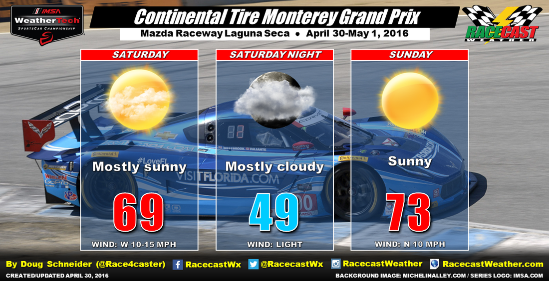
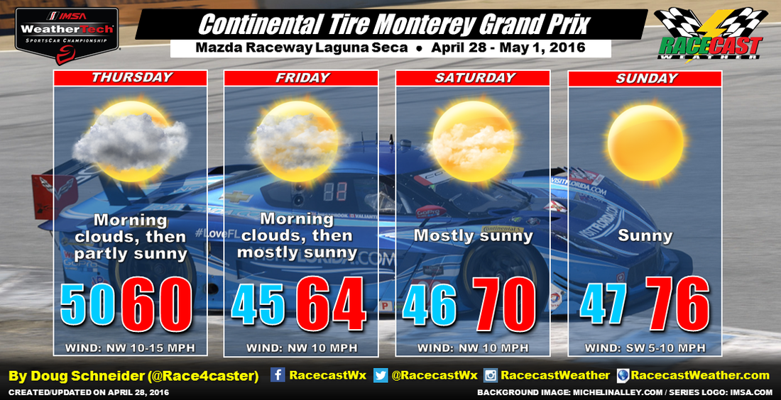
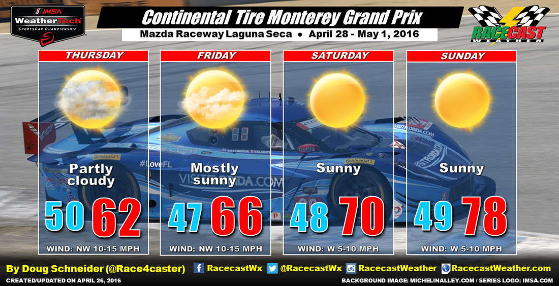
The past couple of days at Mazda Raceway have been cloudy and cool. That should start to change today. The westerly direction of the wind above the surface has been transporting moisture off the Pacific Ocean, but today, those winds aloft will shift to a more northerly direction. There will be more sun than clouds today, which will allow temperatures to rise into the upper 60s. Clouds may develop tonight and early Sunday morning, but they should be gone by the time teams hit the track. Race day looks like it will have great weather, with sunny skies and highs in the lower 70s.
By Doug Schneider Typical central California weather is expected for the Continental Tire Grand Prix at Mazda Raceway Laguna Seca this weekend. Yesterday, a low pressure system moved through and brought some clouds and light rain to welcome teams to the track. But the rest of the weekend will be dry.
Today will begin with overcast clouds, which is typical for the Monterey Peninsula when there is a good northwest wind. Moisture off the Pacific Ocean will hold these clouds in place through most of the morning, but there should be some breaks in the cloud through the afternoon. This will keep temperatures cool, with a high only around 60. Tomorrow looks pretty similar to today, with some morning clouds lifting in the afternoon. A little more sunshine will bring temperatures up into the mid 60s on Friday. Temperatures will continue to warm as more sunshine is expected for Saturday and Sunday. Again, some morning clouds will be possible, but each day should see more sunshine than the day before. Temperatures will rise to near 70 on Saturday, and the mid 70s on Sunday. By Doug Schneider Apologies for getting this forecast up on the blog a day later than usual. I had a great weekend at Barber, and had some work to catch up on after recently moving to a new house.
Fortunately, it looks like the weather won't be a problem at Mazda Raceway Laguna Sece this weekend. The weather pattern for the end of the week will feature a low pressure trough over the Rockies, with a high pressure ridge off the California coast. This will provide a dry northerly flow through the atmosphere across the Monterey Peninsula. Initially, this will keep temperatures on the cool side for Thursday and Friday, with highs in the 60s. Temperatures will gradually warm through the weekend, with highs on Sunday reaching into the upper 70s. By Scott Martin. After a day that featured a mix of clouds and sun, then a light shower, then clouds, then a thunderstorms, and finally back to a mix of clouds and sun, I am sure glad to say that the tricky part of the forecast is over.
As an upper-level trough finally moves off to the east away from Alabama, and a ridge starts to build close-by, don't expect anything less than a near-perfect weekend weather-wise. Highs on Saturday will reach the mid to upper 70s, with the morning low around the mid 50s. A northwest wind at 5-10 MPH, along with dewpoints in the low 50s, will make the day very comfortable. Sunday will be warmer, with highs reaching the low 80s, and the morning low in the mid 50s. Winds will be from the southeast at 0-5 MPH. Dewpoints will once again be in the low to mid 50s. By Scott Martin. Skies will be cloudy throughout most of the morning on Friday. Looking at the latest model runs, the NAM 4k is having the main focus of rain to be out of the area by 11:00 AM, with showers and thunderstorms developing during the afternoon as instability values rise. There is a good chance that those storms will miss the track, but not absolutely certain on location and on timing. The storms that develop during the afternoon could be strong, with small hail, gusty winds, and dangerous lightning as the main threats. Storms should stay below severe limits.
After these storms move through during the afternoon hours, skies will start to clear out and the weekend looks to be super. Expect sunny skies and warm temperatures. Highs in the upper 70s to near 80 on Saturday, and low to mid 80s on Sunday. By Scott Martin. THURSDAY
Day will start off partly to mostly cloudy, with clouds building throughout the morning. Latest HRRR model run has rain not reaching the area until the 11AM to 2PM time frame, even though some scattered light showers could form and move through before then. The rain won't be too widespread, and the sun may peak out at times. Rain amounts should total 1/4 inch or less. Early Morning Low: Mid 50s Highs: Mid 70s FRIDAY A good part of the day should be dry with only widely scattered showers. As the afternoon progresses, the air will become more unstable and heavier thunderstorms will form. Surface-based instability (CAPE) values will approach 2000 j/kg by mid-afternoon, but the overall dynamic support will be weakening and major severe weather issues are not expected. Currently, the best chance of the stronger storms will come east and south of the track, but it will be a close call. Don't be surprised if some small hail and gusty winds are involved with these storms. Just remember, if you can hear thunder, you are close enough to be struck by lightning. Early Morning Low: Lower 60s Highs: Mid 70s SATURDAY Skies should be mostly sunny throughout the day, and the night should be clear. Early Morning Low: Mid 50s Highs: Upper 70s SUNDAY Sunny skies and warmer temperatures at the track. A near-perfect day for racing. Early Morning Low: Upper 50s Highs: Lower 80s By Scott Martin. First of all, I want to start off this week's forecast with an apology to you, our blog readers. If you noticed, blog entries for the past event were down from the normal output from what Doug and myself put out. Long Beach was my responsibility, and I failed in keeping the latest info updated on the blog. For that, I am truly sorry. Now I can go on and rattle off a bunch of reasons why, but it does no good in the end. Now, with that being said, here is the first look forecast for my home race, the Honda Indy Grand Prix of Alabama. There will be an upper-level low making its way across the plains and will be close enough to affect the weather here in the deep south. Thursday will start off mostly cloudy, with showers and thunderstorms moving into the area during the late afternoon and early evening timeframe. The rain will persist until early Friday morning, when the low being forced off to the east by an approaching upper-level trough that will be off the coast of the Pacific Northwest. After that, skies will become partly cloudy by the late afternoon, and clear out for the remainder of the weekend. Temperatures will be warm for the events, as highs will reach the upper 70s to the lower 80s throughout the weekend. Sunday we might even flirt with the mid 80s.
Since rain will be involved this week, I will have radar for the track operating on the site (RacecastWeather.com), along with updates each day on our blog. I will also have updates on all of our social media feeds (located on the right of the page). This is such an exciting time for myself. I get to see friends from the previous years' events, and get to make new ones this year. Both Doug and myself will be attending the race again this year. So if you see us there, please be sure to stop us and talk. Have a great week. By Doug Schneider
I ran across this graphic today that shows what you should do if you are caught outside when lightning is nearby. Of course, the best option is to find shelter. But at race tracks, that is often not an option for everyone. If you have no other choice, this is the position that will give you the best chances of surviving a lightning strike. (H/T - Mike Smith Enterprises Blog) |
Social Feeds
Authors
Doug Schneider Partners
Categories
All
Archives
December 2024
|