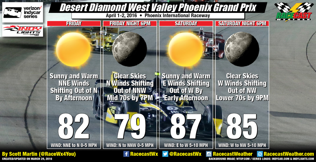
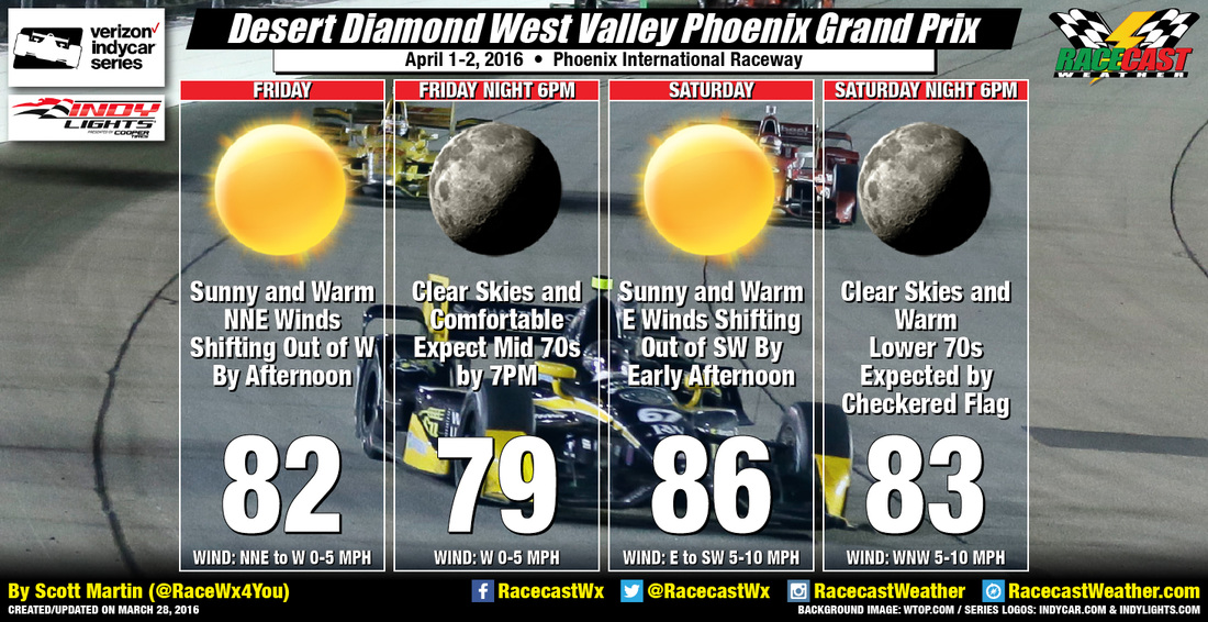
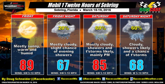
Racecast Weather - Your Source for Race Weather Information
  • Racecasts
  • Radar
  • 2019 Schedule
  • Links
  • Bios
  • Contact

Wednesday Update for Indycars & Indy lights at Phoenix

3/30/2016

0 Comments

 
By Scott Martin.
Picture
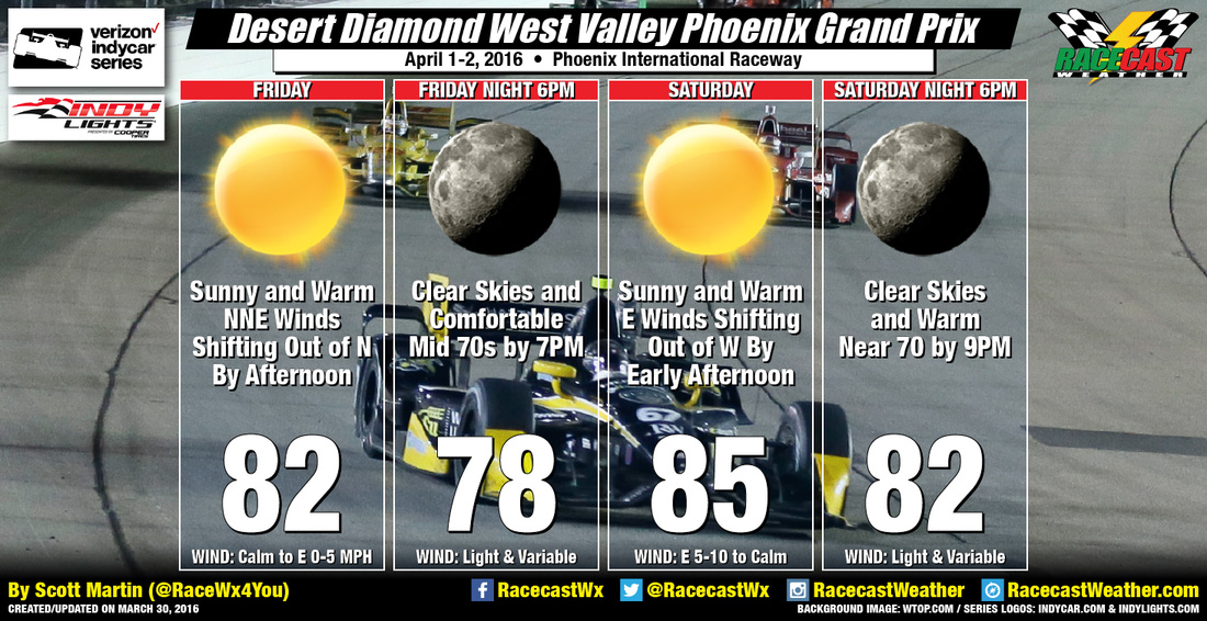
Forecast is still on track for the Verizon Indycar Series and the Indy Lights Series. It will be really nice this weekend at Phoenix International Raceway, as a high amplitude ridge will be building in over the western United States during the weekend. This will allow for temperatures to be well above normal for this time of year, and it will keep rain chances out of the forecast. Sunny skies and warm temperatures with daytime highs in the lower to mid 80s for both days, with evening temps starting off in the upper 70s to lower 80s on both nights. Winds will be light and variable for both evenings, and rain is not a factor at all.
0 Comments

Tuesday Update for Indycars & Indy lights at Phoenix

3/29/2016

0 Comments

 
By Scott Martin.
Picture
The weather is looking really nice this weekend at Phoenix International Raceway, as a high amplitude ridge will be building in over the western United States during the weekend. This will allow for temperatures to be well above normal for this time of year, and it will keep rain chances out of the forecast.

FRIDAY
A beautiful day at the track, as skies will be sunny and clear throughout the day. Temperatures will start of in the lower 60s at 9AM, and warm to a daytime high in the lower 80s. Temperatures will drop back down to the mid 70s by 7PM. Winds will start off out of the north-northeast at 5 MPH in the morning, but will be shifting out of the north-northwest at 5 MPH by late afternoon.

SATURDAY
Another great day at the track, but it will be warmer. Skies will once again be clear throughout the day. The high temperature for the day will be in the mid to upper 80s, and will be in the mid 80s at 6PM. Temperatures will fall to the lower to mid 70s by the time the checkered flag falls at 8:30PM. Winds will start off out of the west at 5-10 MPH in the morning, but will be shifting out of the northwest at 5-10 MPH by late afternoon.

0 Comments

First Look Racecast for Indycar & Indy Lights at Phoenix

3/28/2016

0 Comments

 
By Scott Martin.
Picture
A welcome back to Phoenix International Raceway for the Verizon Indycar Series, and the Indy Lights Series will be joining them on this trip out to the Southwest. Great weather is in store for the action at the track, and I do not believe that there will be any complaining. There are two things to expect during this weekend: winds will be shifting a lot during both days, and there is no rain in the forecast at all.

FRIDAY
Action is planned to start at 9AM with the 1st practice session for the Indy Lights series. Skies will be sunny and temperatures will be in the lower 60s. By the time the Verizon Indycar Series gets the green flag at 10AM for the start of their 1st practice session, it will have warmed into the upper 60s to near 70, and will reach the lower to mid 70s by the end at 11:15AM. Winds will start off out of the north-northeast and may shift a little during the morning to out of the ENE.

At 1PM, temperatures will have climbed into the upper 70s to near 80, and winds will have started their shift as expected and will be out of the north for the start of the 2nd practice session for the Indy Lights series. Qualifying for the Verizon Indycar Series is up next starting at 2PM, and temperatures will have reached the lower 80s with winds now out of the northwest, and should be out of the west completely by the time the last attempt is finished.

Temperatures will start to fall very slowly after that and will be in the upper 70s to near 80 when the Indy Lights series takes to the track for their qualifying runs, and the mid 70s by the time the final practice session is finished for the Verizon Indycar Series is over at 6:45PM.

SATURDAY
Temperatures will be in the mid 60s, and skies will be sunny at 9AM on race day. No track activity is scheduled until 1:25PM, when the Indy Lights series gets the green flag for their 90-lap race. Temperatures will be in the lower 80s by that time, with winds already starting their expected shift from the east during the morning hours to out of the south. By the time the checkered flag falls at approximately 2:15PM, it will have reached the middle 80s and winds out of the south-southwest.

By the time the green flag falls for the Verizon Indycar Series at 6:15PM, temperatures will still be hanging around the lower to mid 80s and winds will then be out of the west-northwest. Temperatures are expected to fall into the lower to mid 70s by the time the checkered flag falls at the expected finish time of approximately 8:30PM. Winds will be out of the northwest at that time.

There will be no radar coverage for this week's events due to possible severe weather expected for my neck of the woods (Alabama), and I will need it to help out with coverage. I will have updates on our social media feeds and on the blog throughout the week. Have a great day.
0 Comments

Racecast verification and a review of weather safety at the 12 Hours of Sebring

3/20/2016

2 Comments

 
By Doug Schneider
Picture
The forecast for Sebring worked out really well, with the rain on race day predicted the Sunday before the race with a 50% PoP. Friday ended up being dry, but I had only a low chance PoP in the forecast a few days earlier. Forecast high temperatures were never off by more than 5 degrees. The timing of the arrival of the rain on Saturday was forecast pretty well, as my Thursday forecast update mentioned that Saturday afternoon and evening would have the best chances of rain. The race day forecast targeted the arrival of the main area of heavy rain and lightning between 1 and 2 pm, which verified well. A brief shower arrived around 12:30, with the first lightning strike within 8 miles occurring around 12:50, with the main area of storms that stopped the race arriving around 2 pm. Forecasting rainfall amounts in Florida is always a challenge due to the often hit-or-miss nature of the thunderstorms and heavy rain, and amounts can vary wildly over short distances. I was expecting somewhere between a quarter and a half inch of rain, with more possible within stronger storms, and there ended up being 0.74" at a nearby observation site. Some other sites a little farther from the track got over one inch.

The Storm Prediction Center issued a Severe Thunderstorm Watch near Sebring at 1:15 pm, mentioning a potential threat of damaging wind gusts and large hail. While the highest gust I saw at nearby observation sites was around 20 mph, there was some wind damage east of Lake Okeechobee, and even a tornado near Fort Lauderdale. Thankfully, it sounds like everyone at the track was safe and there was no significant damage.

I applaud IMSA for doing their part in keeping the drivers, teams, and track marshals safe from the hazardous weather. They red flagged the race before the frequent lightning arrived at the track. The TV crews were brought down from their scaffolding as soon as lightning was observed nearby. However, it sounds like safety efforts for the fans were lacking in some respects.

I asked some fans who were at the race how they were informed of the approaching weather and the need to take shelter. I received mixed responses. Katie Mech said she was only notified by a text message from a friend. Michael Goodwin said he was notified through the Radio Le Mans broadcast, but not through the PA system. Charley Robertson was notified by the Corvette Car Corral. The fans who replied to me via Facebook mentioned that they were well informed of the situation by PA announcements and the radio broadcast. Others were notified by police officers of the approaching storms (see comment on this post). So it seems that some fans got a message from the track officials, but others did not. Vickie Miller told me that the PA speakers at the track are few and far between, and often cannot be heard when cars are on track. Both Katie and Vickie said that there were no messages on the video screens to alert fans to seek shelter - only a weather map was displayed. And police officers can't reach every person. So whether the message was heard probably depended on where fans were located and whether they were listening to the radio broadcast at the time. Vickie summed up the PA message that she heard this way:
Picture
​I noticed that there was one Tweet sent from Sebring Raceway that mentioned the hazardous weather: 
Picture
This tweet was sent more than half an hour after the Severe Thunderstorm Watch was issued, and about one hour after the first lightning strike occurred within 8 miles of the track. 

From the information I've gathered, the track could have done a better job of communicating the threat to the fans and keeping them informed. There's no excuse for the lack of a message on video screens. A video message is important as the PA system often can't be heard over the sound of the cars. In addition, social media could have been used more effectively. In my interview with other tracks about their hazardous weather policies, I learned that social media is an important channel for tracks to get messages out to fans. There were many tweets from myself, Scott, and from others about the approaching weather well in advance, several of which tagged the track, but the track's official Twitter account was silent until this tweet. ​Sending out one tweet an hour after the threat first become imminent is not enough. Vickie told me that she used Twitter frequently at Sebring to get weather information, and she found it very helpful to know where the rain was located. There wasn't much effort from Sebring Raceway to keep fans informed and help direct fans to safety. There aren't many places at Sebring to find shelter, but at a minimum, they could have retweeted me: 
Picture
2 Comments

Race day weather: 12 Hours of Sebring

3/19/2016

0 Comments

 
By Doug Schneider
Picture
Here's what the radar is showing across Florida and the Gulf of Mexico this morning (Sebring is near the red dot): 
Picture
There's not much activity near Sebring as of 8 am, but you can see a large area of showers with some thunderstorms that is moving toward the east-southeast. These showers are expected to arrive in the Sebring area this afternoon, roughly between 1 pm and 3 pm. This image of model-simulated radar shows what the radar might look like around 3 pm:
Picture
Don't take that image too literally as it is a model simulation and subject to errors, but this does give a rough idea of the timing of showers and thunderstorms in the area. Other models support this timing, so I have the highest rain chances today around 2 pm. 

The Storm Prediction Center has Sebring in a marginal risk area for severe thunderstorms. Don't get too excited or nervous about that. A marginal risk is very low, but it is non-zero. There may be some gusty winds with the storms, perhaps 30-40 mph. Rain could be briefly heavy too. Total rainfall amounts today are expected to be between a quarter and a half inch, although if a heavier storm moves right over the track, amounts could be higher. 

Once this complex of storms moves through, the chances of rain will be decreasing. There could still be a shower into the overnight hours, but the coverage of showers around the area should be less than in the afternoon. 

You can watch the radar by clicking on our live radar feed at the top of the page. I'll be updating conditions from my Twitter account - @Race4caster. 
0 Comments
<<Previous

    Social Feeds


    Instagram

    Instagram

    Partners

    Picture
    Picture
    Picture
    Picture
    Picture

    Authors

    Doug Schneider, Scott Martin, and Stephen McCoy are race fans and meteorologists dedicated to providing accurate forecasts and timely weather updates at racing venues around the world. We forecast for IndyCar, Indy Lights, Pro Mazda, USF2000, IMSA, Pirelli World Challenge, World Endurance Championship, and Trans Am Series races, as well as major SCCA and NASA events.


    Categories

    All
    F1
    IGTC
    IMSA
    Indycar
    Le Mans
    MRTI
    NASA
    Outlooks
    Photos
    PWC
    Racecasts
    SCCA
    Trans Am
    TUSC
    Verification
    Weather Education
    WEC


    Archives

    January 2019
    December 2018
    November 2018
    October 2018
    September 2018
    August 2018
    July 2018
    June 2018
    May 2018
    April 2018
    March 2018
    February 2018
    January 2018
    December 2017
    November 2017
    October 2017
    September 2017
    August 2017
    July 2017
    June 2017
    May 2017
    April 2017
    March 2017
    February 2017
    January 2017
    December 2016
    November 2016
    October 2016
    September 2016
    August 2016
    July 2016
    June 2016
    May 2016
    April 2016
    March 2016
    February 2016
    January 2016
    December 2015
    November 2015
    October 2015
    September 2015
    August 2015
    July 2015
    June 2015
    May 2015
    April 2015
    March 2015
    February 2015
    January 2015
    December 2014
    November 2014
    October 2014
    September 2014


Powered by Create your own unique website with customizable templates.