Racecast Weather - Your Source for Race Weather Information
  • Home
  • Racecasts
  • 2023 Schedule
  • Services
  • Contact
  • Bios
  • Links

Forecast for the NASA 25 Hours of Thunderhill

11/29/2015

Comments

 
By Doug Schneider
Picture
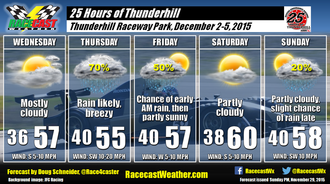
The final event on our forecast schedule this year is the 25 Hours of Thunderhill near Willows, California. And it looks like there will be a mix of wet and dry conditions through the event, with temperatures close to normal for this time of year in Northern California.

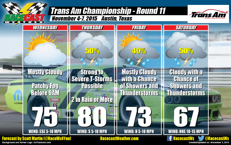
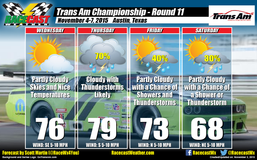
Paddock setup on Wednesday will be mostly cloudy with temperatures topping out in the upper 50s. A low pressure system will be approaching from the west on Thursday, which will likely bring some rain to the track for the testing session. It will be breezy as the low pressure system gets closer, with winds of 10 to 20 mph. The rain will likely continue into Thursday night and early Friday morning as the cold front moves through the area. The total amount of rainfall is expected to be between a half inch and one inch. At this time, I expect that most of the rain will end in time for the start of testing at 9 am Friday. Clouds will be decreasing through the day as the low pressure system exits and high pressure builds over the area.

Saturday will likely have the nicest weather of the event, with partly cloudy skies and high temperatures near 60 degrees. Right now, I am fairly confident that the entire 25 hours of racing will be dry. There is another low pressure system that will be approaching on Sunday, but it looks like any rain with this system will hold off until late in the day, well after the end of the race. 
Comments

Friday forecast update: Trans Am and Classic 24 Hour at Daytona

11/13/2015

Comments

 
By Doug Schneider
Picture
Yesterday's high temperature at Daytona reached a balmy 87 degrees. Temperatures will be cooler for the rest of the weekend, but there's not much to complain about weatherwise (unless you're one of those people from Florida who thinks temperatures below 60 degrees are cold). 

Some fog will be around the track once again this morning, but like yesterday, it should be cleared out by 9 am or so. A cold front is located across southern Georgia this morning, and it will be moving through the area late today. Cooler temperatures will arrive tomorrow behind the front, along with breezy conditions. Winds will be 10 to 20 mph on Saturday, producing a headwind on the backstretch and a tailwind on the frontstretch. Gusts of 25 to 30 will be possible at times. Mostly sunny skies will continue into Sunday, with temperatures warming into the upper 70s.
Comments

Tuesday forecast update: Trans Am and Classic 24 Hour at Daytona

11/10/2015

Comments

 
By Doug Schneider
Picture
Today's forecast looks pretty similar to the one I posted on Sunday, so the forecast is progressing as expected. I did bump temperatures up a few degrees as it looks like highs will reach between 80 and 85 Wednesday through Friday. The cold front that will pass through Friday night will not have any rain with it. However temperatures will be noticeably cooler on Saturday, and it will be breezy with north winds at 10-15 mph gusting to 25 to 30 mph at times. Overnight temperatures Saturday night will be on the chilly side for the Classic 24 Hour, dropping into the upper 50s.
Comments

Forecast for Trans Am and Classic 24 Hour at Daytona

11/8/2015

Comments

 
By Doug Schneider
Picture
The weather looks absolutely picture perfect for the Trans Am Series finale and the HSR Classic 24 Hour at Daytona International Speedway next weekend. No rain is expected through the entire event, and I'm pretty confident that this dry forecast will hold up through the week as the models are in good agreement with each other and have been consistent over the past few days with the pattern.

A large area of high pressure will be across the eastern United States, providing sunny skies and pleasant temperatures as teams arrive on Wednesday. Temperatures will be even warmer by Thursday as the high pressure area moves south and east, and highs on Thursday will reach into the lower 80s.

A cold front will be crossing northern Florida on Friday, but its passage is expected to be dry. The only noticeable difference with the front will be a few more clouds and a shift of winds to the north. Cooler temperatures will arrive behind the front for Saturday, as highs will be in the lower 70s. It may be breezy as well, with north to northeast winds of 10 to 15 mph, gusting to 25 mph at times. This will be a headwind down the backstretch and a tailwind on the frontstretch. A low pressure system will be developing near Texas on Sunday, which will spread some high clouds into the area, but any rain with this system should hold off until Monday. 

For forecast updates on Twitter, follow @Race4caster. Updates will also be posted on the Racecast Weather Facebook page.
Comments

Friday AM Forecast Update for Trans Am at COTA

11/6/2015

Comments

 
By Scott Martin
Picture
Picture
Sometimes you can get it right, and sometimes you can get it wrong. Looking back at the daily record from nearby Austin-Bergstrom International Airport, there was no measurable rain to speak of within the last 24 hours. And since there was no rain, the temperature were able to climb to the upper 80s.

At 6:40AM, there are showers south of the area continuing to push to the south. There is also a storm back off about 125 miles to the west-southwest of the track that is heading to the east-northeast. If those hold together, they should arrive sometime between 11:30AM and 1:00PM.

So for today, we'll go with cloudy skies with a chance of showers and thunderstorms. Highs should reach the lower 70s. Winds will be out of the northwest at 5-10 MPH. Chance of rain is 50%.

Saturday looks like it will be cloudy with showers and maybe a thunderstorm likely before 12PM. After that, skies will remain cloudy with a chance of showers and a thunderstorm. Highs should reach the mid 60s. Winds will be out of the north at 10-15 MPH, with gusts up to 25 MPH. Chance of rain is 60%.

I'll have updates on my Twitter feed (@RaceWx4You) if threatening weather approaches the area. Live radar is also up and running on our site at www.racecastweather.com. Have a great day.
Comments

Wednesday PM Forecast Update for Trans Am at COTA

11/4/2015

Comments

 
By Scott Martin
Picture
Picture
NOAA/NWS SPC Severe Outlook
(valid Thursday 6AM-Friday 6AM)
Picture
NOAA/NWS Day 1-2 QPF Chart
(valid Wednesday 6PM-Friday 6PM)
Looking over the latest data that is pouring in from the models and the NWS, I do not believe in much change from yesterday's forecast update. The Storm Prediction Center has placed much of Texas (including COTA) under a SLIGHT RISK for severe weather for Thursday. A shortwave impulse will be moving through the area during the morning hours with enough instability for strong to severe storms to develop. These storms could produce heavy rainfall amounts, some strong winds at 40-60 MPH, and a brief spin-up tornado can't be ruled out. Models are suggesting rainfall totals with the morning storms at 2 inches or more possible. There should be a break in the action at some point during the mid to late afternoon hours before the cold front moves through the area. That will bring with it more strong thunderstorms, with gusty winds and more heavy rainfall.

Please have a reliable source of weather information on hand during the day, and stay weather aware. Expect heavy rainfall with possible flash flooding, dangerous lightning, strong winds at 40-60 MPH, and a possibility of a brief spin-up tornado. We'll have our radar up and running for you to see at our website (www.racecastweather.com) that features live warning data. I'll also have updates on my Twitter feed (@RaceWx4You) if dangerous weather is heading in that direction.

On Friday and Saturday, the cold front slows down just to the south of the area and an upper-level disturbance behind the front should keep showers and thunderstorms in the forecast throughout the race weekend. Fortunately, these storms will be elevated, so no severe weather is expected with these storms.
Comments

Tuesday PM Forecast Update for Trans Am at COTA

11/3/2015

Comments

 
By Scott Martin
Picture
Picture
Storm Prediction Center Severe Outlook
(valid Thu 6AM - Fri 6AM)
Picture
GFS Total Accumulated Precipitation
(valid Wed 12AM - Sat 12AM)
As I posted earlier today on Twitter, there is a marginal risk for severe weather for the area on Thursday. A shortwave trough will approach the area on Wednesday night, bringing a cold front with it. As the front moves in to the tropical air mass in the area, we can expect strong to severe convective thunderstorms at some point starting during the late evening on Wednesday and into Thursday. Rain on Thursday morning could be heavy at times, with flash flooding possible. There will probably be a lull in the action until storms start firing along the cold front. Conditions could be favorable for some strong to severe storms during the late afternoon and evening hours, with damaging winds as the main threat. Although not favorable as of now, I still can't rule out the possibility of an isolated tornado. As with thunderstorms you should always expect the unexpected.

It looks like the front will make it south of the area by Friday, but an upper level trough will hang back to the west of the area. This will keep rain and thunderstorm chances in the forecast on Friday evening through the day on Saturday. Good news is that there is no threat of severe weather.

Unfortunately, models are lining up in decent agreement that the COTA area will be receiving plenty of rainfall from this system. Since the ground has been saturated lately due to previous lows and the remnants of Patricia, flash flooding could be a possibility. As shown in the graphics above, the GFS total accumulated precipitation model run (valid at midnight on Saturday) is projecting 2 inches of rain for the area. I wouldn't be surprised if totals are higher underneath a heavy thunderstorm.

Bottom line for this situation... stay weather aware. Have a reliable source of weather information on hand. I will have updates on my Twitter feed (@RaceWx4You) throughout the week and will have radar images posted. If anything changes with this forecast, check back on our website (www.racecastweather.com) or on my Twitter feed. I hope this forecast is totally wrong and the week turns out dry. Let's cross our fingers.
Comments

Forecast for Trans Am Action at COTA

11/2/2015

Comments

 
By Scott Martin
Picture
The Trans Am season is starting to wind down as we have now reached the next-to-last event on the 2015 schedule. As of the latest data, there will be some rain involved through the area.

WEDNESDAY
Skies will be mostly clear to start off the day, but more clouds will start to move in as an approaching trough gets closer to the area. So expect partly cloudy skies and nice conditions. Highs will reach the mid-70s. Winds will be from the southeast at 5-10 MPH. Chance of rain is 0%.

THURSDAY
The trough will be moving through the area and bring with it rain and thunderstorms, along with a cold front. Expect heavy rain at times, with a possibility of rainfall totals over 1 to 1-1/2 inches. Unfortunately, this setup will keep decent rain in the forecast through Friday night. Highs will reach the upper 70s to near 80. Winds will be out of the south at 5-10 MPH. Chance of rain is 70%.

FRIDAY
As the trough starts to lift out of the area, there is still rain and thunderstorm chances in the mix. Partly cloudy skies may give way to showers and thunderstorms during the day. Highs will reach the lower to mid-70s. Winds will be out of the north at 5-10 MPH. Chance of rain is 40%.

SATURDAY
Conditions should start to dry out as northerly winds start to bring in drier air in. With that drier air comes cooler temperatures. Skies should be partly cloudy with a slight chance of a shower or thunderstorm during the morning and early afternoon hours. Conditions will improve as the day progresses. Highs will reach the upper 60s. Winds will be from the north at 5-10 MPH. Chance of rain is 30%.

Please be sure to follow my Twitter feed at @RaceWx4You for the latest update to the forecast.
Comments

    Social Feeds


    Instagram


    Authors

    Doug Schneider
    Scott Martin
    Stephen McCoy

    Harris Cooley 


    Partners

    Picture
    Picture
    Picture
    Picture
    Picture

    Categories

    All
    F1
    IGTC
    IMSA
    Indycar
    Le Mans
    MRTI
    NASA
    Outlooks
    Photos
    PWC
    Racecasts
    SCCA
    SRO
    Trans Am
    TUSC
    Verification
    Weather Education
    WEC


    Archives

    March 2023
    February 2023
    January 2023
    December 2022
    November 2022
    October 2022
    September 2022
    August 2022
    July 2022
    June 2022
    May 2022
    April 2022
    March 2022
    February 2022
    January 2022
    December 2021
    November 2021
    October 2021
    September 2021
    August 2021
    July 2021
    June 2021
    May 2021
    April 2021
    March 2021
    January 2021
    December 2020
    November 2020
    October 2020
    September 2020
    August 2020
    July 2020
    June 2020
    March 2020
    January 2020
    December 2019
    November 2019
    October 2019
    September 2019
    August 2019
    July 2019
    June 2019
    May 2019
    April 2019
    March 2019
    February 2019
    January 2019
    December 2018
    November 2018
    October 2018
    September 2018
    August 2018
    July 2018
    June 2018
    May 2018
    April 2018
    March 2018
    February 2018
    January 2018
    December 2017
    November 2017
    October 2017
    September 2017
    August 2017
    July 2017
    June 2017
    May 2017
    April 2017
    March 2017
    February 2017
    January 2017
    December 2016
    November 2016
    October 2016
    September 2016
    August 2016
    July 2016
    June 2016
    May 2016
    April 2016
    March 2016
    February 2016
    January 2016
    December 2015
    November 2015
    October 2015
    September 2015
    August 2015
    July 2015
    June 2015
    May 2015
    April 2015
    March 2015
    February 2015
    January 2015
    December 2014
    November 2014
    October 2014
    September 2014


Powered by Create your own unique website with customizable templates.