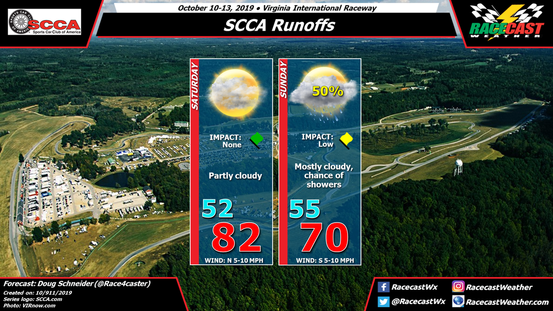
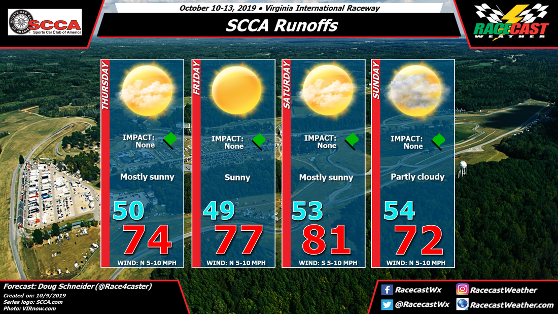
A cold front is expected to move into the area Saturday night, which is in line with the previous forecast thinking. However, the models are now showing this front slowing down and stalling as it moves into the Piedmont of NC and VA. It is expected to be located just southeast of VIR on Sunday. Meanwhile, an upper level disturbance will be approaching, and its interaction with this front will produce some showers in the area. Rain is possible any time of the day on Sunday, but it appears that the best chance of rain will come in the afternoon. Rain amounts in the neighborhood of a tenth of an inch can be expected. Since this isn't expected to be a heavy rainfall, and no lightning is expected, I kept the impact as low.
|
By Doug Schneider There has been a pretty big shift in the forecast for Sunday at VIR, and it now appears that there will be a good chance of seeing rain during the day.
A cold front is expected to move into the area Saturday night, which is in line with the previous forecast thinking. However, the models are now showing this front slowing down and stalling as it moves into the Piedmont of NC and VA. It is expected to be located just southeast of VIR on Sunday. Meanwhile, an upper level disturbance will be approaching, and its interaction with this front will produce some showers in the area. Rain is possible any time of the day on Sunday, but it appears that the best chance of rain will come in the afternoon. Rain amounts in the neighborhood of a tenth of an inch can be expected. Since this isn't expected to be a heavy rainfall, and no lightning is expected, I kept the impact as low. By Doug Schneider The forecast that I posted on Sunday appears to be holding up pretty well as we get closer to the weekend, as there has been little change to that forecast with today's update. Nice weather is expected each day as high pressure extends across Virginia and North Carolina Piedmont region. Temperatures will be trending warmer each day through Saturday, then a cold front is expected to move across the area Saturday night.
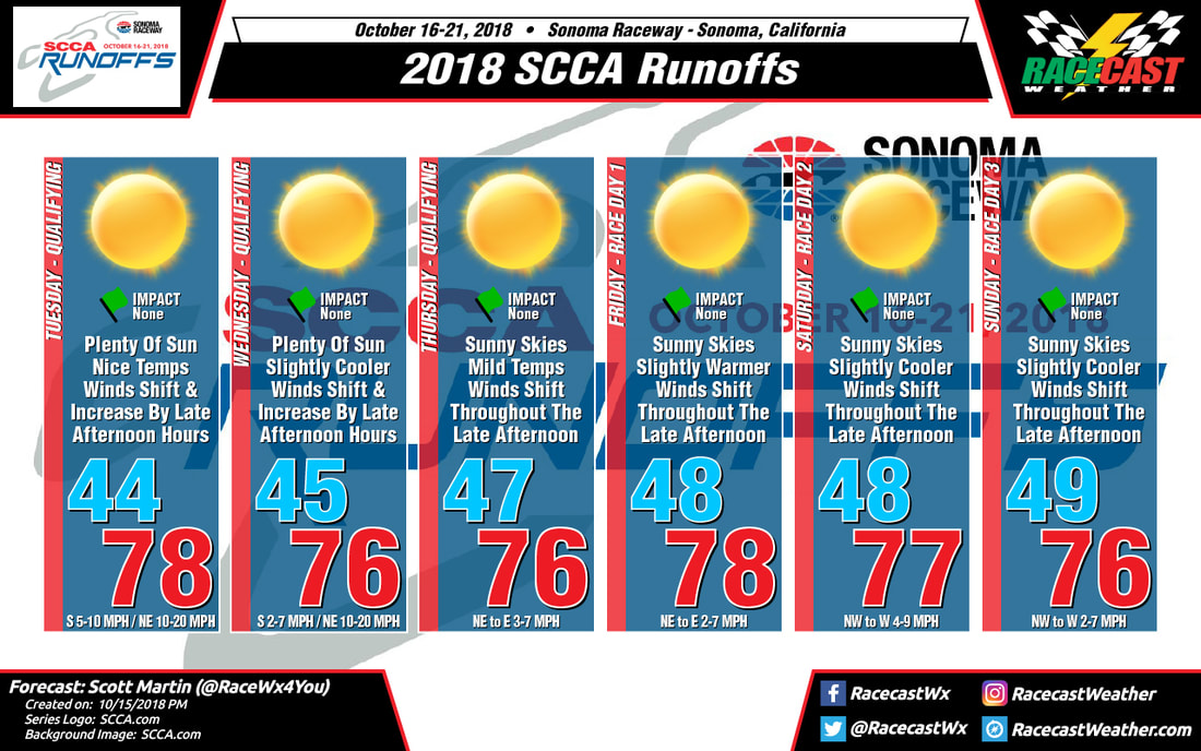
The majority of rain with this front should pass to the north, and I'm keeping my forecast dry. However, there is a model (GFS) that shows some rain occurring Saturday night. So if there is any rain, I expect it won't affect the racing on Saturday or Sunday. With the passage of the front, temperatures will get cooler again on Sunday, with highs in the lower 70s. By Scott Martin You could really say we have a "Carbon Copy Forecast" throughout the event week out at Sonoma Raceway for the running of the 2018 SCCA Runoffs. The reason for not much change in the forecast is that a ridge of higher pressure is located to the north of the state in the Pacific Northwest, while a trough of lower pressure is located over the far southern parts of California and into the desert southwest. In weather terms, this is called a "Rex Block" pattern.
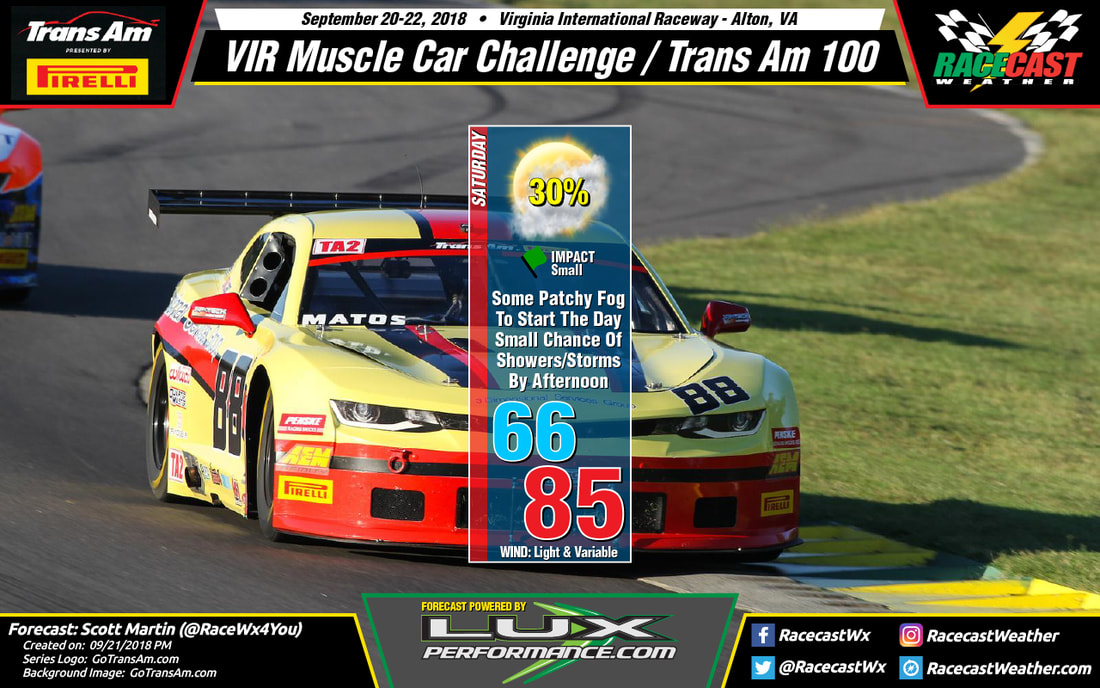
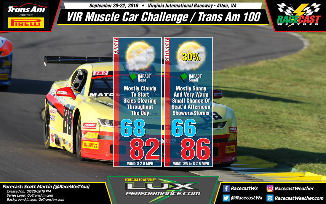
With very little movement in the pattern expected throughout the week and weekend, conditions will stay pretty consistent with the only difference being that winds will weaken some after Wednesday. With the weakening of those offshore winds, we may have to include a chance of fog in the forecast during the morning hours later in the week, but it is just too early to know that for certain at this point. Highs each day will be in the mid to the upper 70s with early morning lows in the 40s. You'll definitely need jackets for the mornings and trade those for shades and sunscreen during the late morning through the afternoon hours. A great week ahead at Sonoma. By Scott Martin (@RaceWx4You) The forecast is still on track for Saturday at VIR as the dome of high pressure has been forced eastward out to see and a cold front with an associated center of low pressure makes its way towards the area. We may have some patchy fog to start off the morning, but that should quickly lift by 8:00 am or so. After that, skies will be mostly clear, but you will notice that the clouds will build in coverage throughout the day. A stray shower may be possible during the late morning hours, but I believe any rain chances will hold off until the early afternoon hours. At this point, I'm going with a 30% chance of a few scattered showers and storms during the afternoon, with the higher chances of heavier storms move in just before sunset. Afternoon highs will top out in the mid-80s and winds will be light and variable through the day. Winds are expected to pick up a little right at the beginning of the evening hours as the cold front gets closer to the area.
By Scott Martin (@RaceWx4You) A big dome of high pressure will be sitting over the area on Friday, allowing the sinking air to squash any chance for any thunderstorm development throughout the day. Skies will start off mostly cloudy, with the possibility of some patchy fog during the early morning hours. The good news is that the fog will be gone by the time the cars take to the track later in the morning. Clouds will dissipate somewhat throughout the day, ending up mostly clear by sunset. Afternoon highs will top out in the lower 80s (and I may have actually been too conservative with the high as the mid-80s are not out of the realm of possibility).
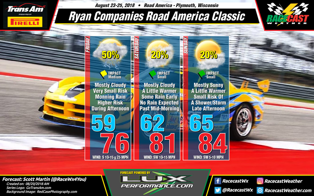
Unfortunately, the high pressure gets quickly pushed off of the coast and is replaced by a center of low pressure and an associated cold front. Skies will be mostly sunny for much of the day and temperatures will be warmer as warm air will be advected into the area from the south. By the time the afternoon arrives, there will be enough lift from the approaching front and instability from the daytime heating to fire off a few scattered showers and storms. Chances will be around 30% while cars are on the track, but those will increase after sunset as the front arrives in the area. Afternoon highs will be in the mid-80s and there will be very little wind to help cool you off. Be sure to stay hydrated, wear your hats and shades, and don't forget to sunscreen up. By Scott Martin We may have some rain to deal with during the event weekend at Road America, but the good news is that the most of that will come on Friday. With that being said, there is a small chance of the wet stuff on Saturday and Sunday.
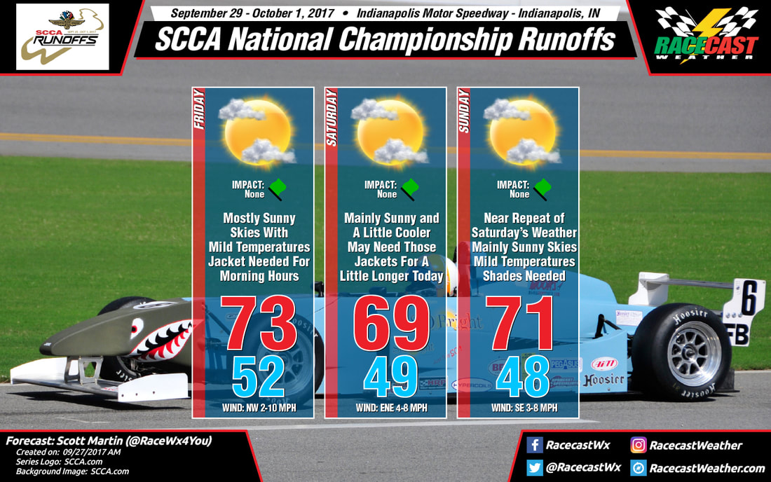
Friday will be the wettest day of the three, with a slight chance of a shower or storm during the morning hours, but with the heating of the day we'll see more showers and storms developing back to the west associated with a low. Those early showers will be isolated to scattered in nature, but the later storms will be more in coverage. Winds will be a little gusty at times as well, up to 25 MPH at times. For the most part, winds will be out of the south at 10-15 MPH. Afternoon highs will be up in the mid-70s, and the chance of rain at this point is around 50%. At this point, it looks like the main concentration of showers and storms should be out of the area by 8AM on Saturday morning, but it will remain a little breezy and mostly cloudy. There may be a lingering shower afterwords for a couple of hours, but the chances of that are really small. Saturday's high will be in the lower 80s, with winds out of the southwest at 10-15 MPH. Sunday will be the best looking day at the track with mostly sunny skies. With the heating of the day we could see the development of an isolated shower or storm around the area, and the chances of one passing over the track is around 20%. It will be warmer and not as breezy, with highs topping out in the mid-80s, and winds out of the southwest at 5-10 MPH. By Scott Martin - @RaceWx4You While the forecast graphic is only for the days with the national championship runoffs, I'm also going to give the forecast for Wednesday and Thursday at Indianapolis Motor Speedway.
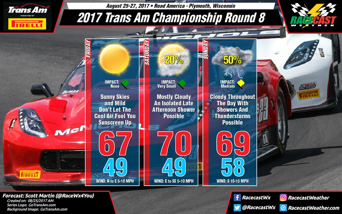
WEDNESDAY Skies will start off partly cloudy this morning with clouds increasing as we head toward the noon hour. There is a very small chance of an isolated shower or thunderstorm during the very early afternoon hours, around 20%. After that, skies will begin the clearing process and should be dry for the remainder of the day. It will be warm today, with the high reaching at or just above 80 degrees. Winds will be out of the north-northwest at 5-10 MPH. THURSDAY No rain expected for Thursday, and for the rest of the weekend at Indy. We'll have mainly sunny skies throughout the day with temperatures starting off in the lower 50s at 7:00 AM, and warming into the lower 70s for the high (around 72 degrees). Winds will be out of the north at 4-8 MPH. FRIDAY-SUNDAY As the forecast graphic shows, we can expect nearly perfect conditions for racing this weekend at Indy. Skies will be mostly clear each day, with highs running in the 69-73 degree range. You will need a jacket for the morning sessions as temperatures will be starting off in the upper 40s to the lower 50s at 7:00 AM each day. You will definitely need the shades, hats, and sunscreen. No umbrellas needed after today, unless you're using one for a little shade. By Scott Martin - @RaceWx4You Well a lot has changed since my last forecast for this weekend's events at Road America for the Trans Am Series Presented By Pirelli. We now will have a chance of showers and thunderstorms to end out the race weekend.
FRIDAY Definitely the best day of the event weekend when talking about the weather. We'll have sunny skies throughout the day today with cool temperatures for late August. Afternoon highs will warm up in the upper 60s after temperatures will be starting off at 50 degrees at 7:00AM. No rain for today, and winds will start off out of the north at 5-10 MPH and shift out of the east by the early afternoon hours. SATURDAY There will be a warm front approaching from the west during the day that will bring an increase of clouds to the area, along with slightly warmer temperatures. It will still be rather cool at 7:00 AM with temperatures starting off in the lower 50s, but afternoon highs will make it to near 70 degrees. Winds will be out of the east at 5-10 MPH to start with, but will shift out of the southeast by the afternoon hours. With the shift in the wind direction, this could bring an isolated shower or two to the area, but with a dry airmass at the surface, you may not see much rain at all. Rain chance will only be at 20% for the late afternoon hours. SUNDAY The warm front will have moved through the area and a center of low pressure will be approaching the state from the west. Along with that, an upper level trough will move into the state from the north allowing that low to deepen. This will increase the chance of showers and thunderstorms throughout the day, especially the early morning through the early afternoon hours. Skies will be cloudy throughout the day, and afternoon highs will be in the upper 60s. The best chance of rain will be during the 1:00 AM - 11:00 AM time frame, with scattered showers possible after that. The chance of rain during event times will be at 50%. |
Social Feeds
Authors
Doug Schneider Partners
Categories
All
Archives
December 2023
|

