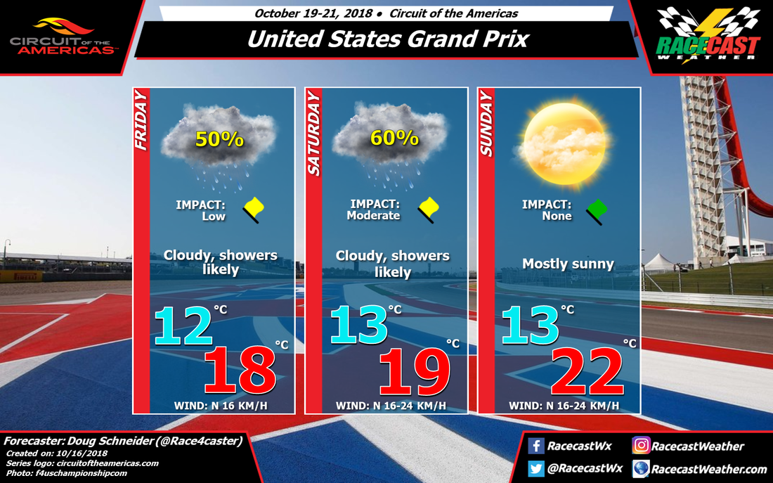
Not Too Bad Weather-Wise For Trans Am At COTA: Trans Am Forecast Powered By LuxPerformance.com10/30/2018 By Scott Martin. 
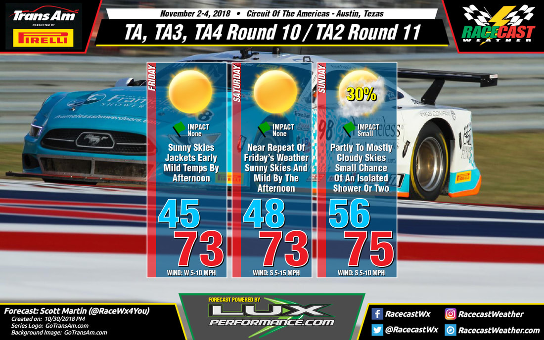
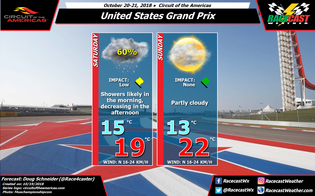
Not too much to complain about out at the Circuit Of The Americas for the next to the last event for the 2018 Trans Am Championship presented by Pirelli, unless we may have to break out the jackets for the morning sessions. Friday and Saturday will feature maximum sunshine with mild temperatures by the early afternoon hours, but early morning lows will start off in the 40s on both days. Unfortunately, I'm going to have to put a small chance of a few passing showers on Sunday as a disturbance will be moving through central and eastern Texas throughout the day, around 30% at this time. I'll be back with a forecast update on Wednesday.
By: Stephen McCoy The models continue a downward trend in the temperatures for the rest of the weekend at the California 8 Hours. In the previous forecast, the surface winds were expected to decrease close to the land with the stronger winds moving further off shore. However in the most recent model runs, winds look to persist off the coast with maximum wind speeds reaching 20-30 mph. As these winds are from the north to northwest, cool air from the Pacific Northwest will continue to move into the region.
The centers of the mid level and upper level ridges previously mentioned are expected to cross into southern Arizona during the late morning on Saturday. Southwesterly winds in the upper levels will bring moisture to the region, however the models (especially the short range models) indicate most of the moisture will be located further to the north, around the Bay area. The result will be mostly sunny skies with some light cloud cover possible through the day. As the upper level ridge continues eastward on Sunday, the band of moisture (extending to the southwest) will also move eastward, passing over the track throughout the morning. As a result, some heavier cloud cover is expected to start the race, but conditions are likely to clear in the late morning to mid-afternoon. Stronger surface winds off the coast will cause winds to pick up slightly during the day with temperatures remaining in the mid to upper 60's. By: Stephen McCoy An upper level ridge, accompanied by a mid-level ridge, will move through the region into early next week. Weak southwesterly flow from the mid level ridge along with northerly flow in the low levels will keep conditions mostly dry through Friday at these levels. In the upper levels, the ridge will cause winds from the southwest, extending from the warmer, more moist portion of the North Pacific Ocean. In turn, some light clouds or partly cloudy conditions are expected as the moisture approaches the region in the upper levels. There has been a slight shift in the high temperature as the model consensus has trended cooler with the addition of the short-range models. Surface winds are likely to blame for the cooler temperatures as the winds just off the coast have an upward trend in wind speed, bringing cool air from the northwest closer to the shore.
Saturday, surface winds are expected to decrease off the coast, which will allow for warmer temperatures. The ridges in the upper levels and mid-levels will continue to track through the region, with the centers passing through overnight on Friday. Moisture is expected to persist in the upper levels, with light clouds to partly cloudy conditions likely again on Saturday. As mentioned in the initial forecast, surface winds will likely come in from the northwest during the day, then shift to the south and southeast during the evening and night as downslope flow occurs from the Santa Lucia Range. On Sunday, the backside of the ridges will be located over the region, with winds primarily from the south to southwest. Moisture is expected to move into the mid and upper levels, resulting in mostly cloudy to overcast conditions throughout the day. The cloud cover along with northwesterly winds at the surface will bring slightly cooler temperatures to the region than seen on Saturday. By: Stephen McCoy Dry air will set up a nice weekend for the California 8 Hours this weekend, with temperatures hovering around 80 and clear conditions expected on Friday and Saturday. Slightly cooler temperatures and mostly cloudy to overcast skies will move in on Sunday.
On Friday, an upper level ridge will move into the region from the west along with a ridge in the mid-levels of the atmosphere. The lack of flow from these ridges accompanied by dry air will result in clear to mostly sunny conditions for the day. The clear conditions will allow plenty of daytime heating to occur at the surface, with the high temperature for Friday approaching 80 degrees. Winds from the northwest during the day are expected to keep dew point temperatures in the upper 40's; winds will likely shift to the south to southeast and weaken slightly during the evening and night as downslope flow occurs off the Santa Lucia Range. Similar conditions are expected for Saturday, with clear conditions more likely as the center of the ridges pass over central California. On Sunday, the ridges are expected to continue tracking eastward, with the backsides moving over the region, and causing upper level and mid level winds to shift towards the southwest. Moisture will move into the mid and upper levels, resulting in mostly cloudy to overcast conditions for the day. Some morning fog is possible in the morning should the low temperature get cool enough to condense near the surface. Cooler temperatures are expected as winds will slightly increase as a stronger pressure gradient sets up just off the coast to the west. By Doug Schneider There hasn't been much change in the expected weather this weekend for F1's visit to COTA. Rain has been a factor at the track for the past few days, although it does not seem heavy enough to really have a big impact on the practice sessions so far. I expect that will continue into Saturday. Rain is likely in the morning, and the track will likely be wet for the F3 Americas Series race. The chance of rain will decrease in the afternoon. Free practice 3 starts at 1 pm CDT, and it will be close as to whether rain will still be around at that time. There's a chance that rain could impact that practice session. However, I do feel fairly confident that rain will be gone in time for qualifying at 4 pm CDT. Rain amounts are expected to be light on Saturday morning, most likely between a tenth of an inch to two tenths (2 to 5 mm).
The weather on Sunday looks nice, with a front pushing south of the area and dry air moving in from the north. It will be on the breezy side, with a north wind a 10 to 15 mph. Temperatures and humidity levels will feel very pleasant, with temperatures during the race near 70 degrees (lower 20s C). |
Social Feeds
Instagram
Partners
Authors
Doug Schneider, Scott Martin, and Stephen McCoy are race fans and meteorologists dedicated to providing accurate forecasts and timely weather updates at racing venues around the world. We forecast for IndyCar, Indy Lights, Pro Mazda, USF2000, IMSA, Blancpain World Challenge America, and World Endurance Championship, as well as major SCCA and NASA events. Categories
All
Archives
December 2020
|