Racecast Weather - Your Source for Race Weather Information
  • Home
  • Racecasts
  • 2023 Schedule
  • Services
  • Contact
  • Bios
  • Links

Forecast update for the Bathurst 12 Hour

1/30/2019

Comments

 
By Doug Schneider
Picture
Picture
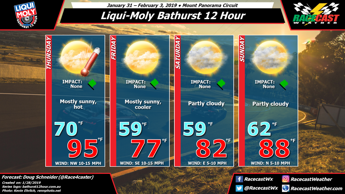
Today's forecast update for the Bathurst 12 Hour has a few small changes in it compared to my last forecast, but overall, the weather continues to look great for racing.

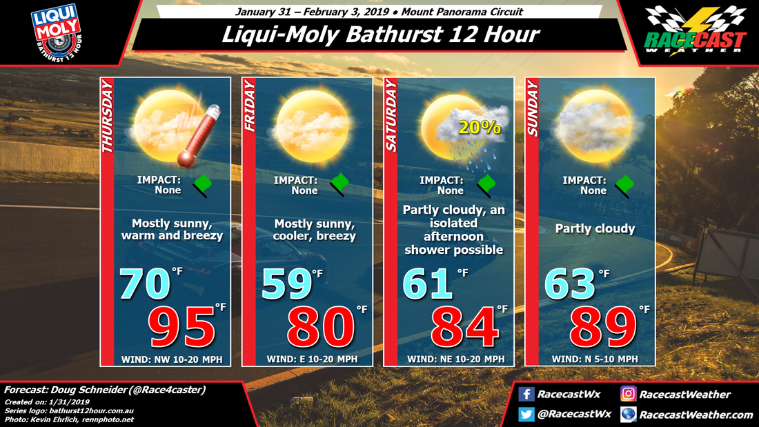
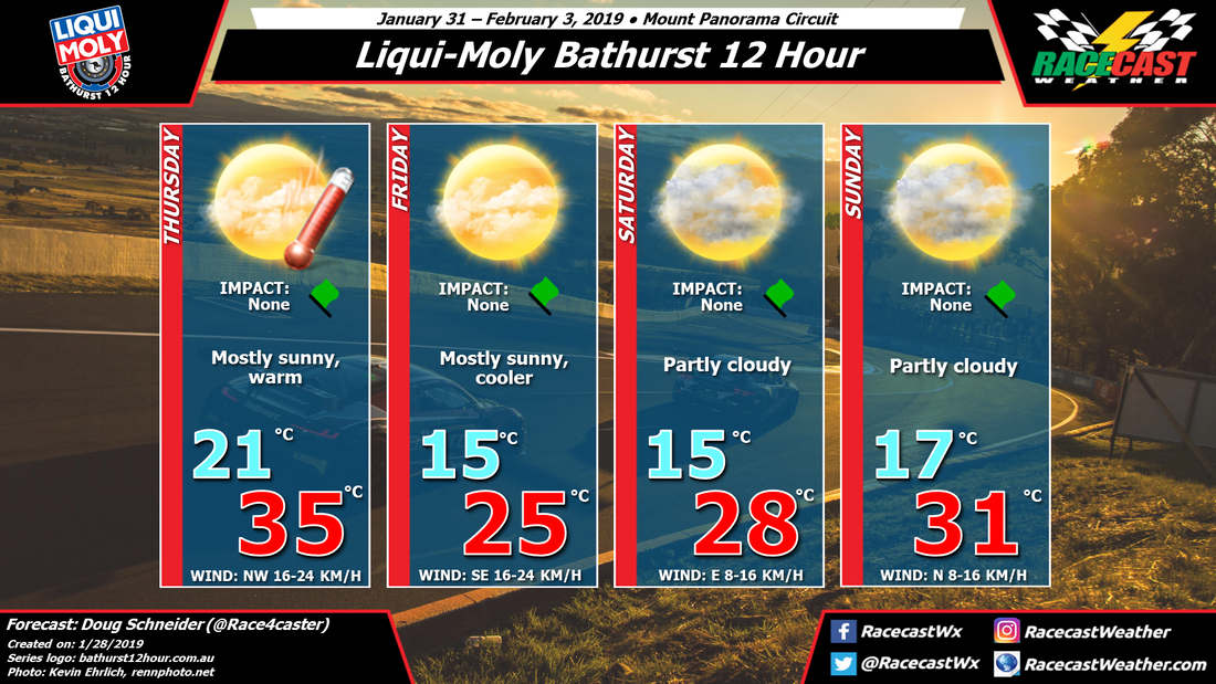
The expected weather pattern across southern Australia hasn't changed significantly, with a large high pressure area off the southern coast expected to drift eastward through the weekend. This high brings cooler and drier air to New South Wales on Friday. I did raise temperatures a couple degrees for Friday and Saturday from my initial forecast.

The main change with the update was to add a mention of a possible afternoon shower on Saturday, as it appears that there will be just enough instability to allow for some showers to pop up. The best chance of showers will be over the higher terrain of the Blue Mountains, east of Bathurst. With the prevailing wind flow coming from the east, some of these showers that develop over the mountains could push west toward Bathurst late in the day. As you can see in the forecast, the chance of a shower happening at the track is low, only 20%. 

The weather for the race looks great, with comfortable temperatures at the start in the upper teens C or lower 60s F. High temperatures during the race will rise into the lower 30s C or upper 80s F. There will be some cloud cover developing in the afternoon hours, but no rain is expected. 
Comments

First forecast for the Bathurst 12 Hour

1/28/2019

Comments

 
By Doug Schneider
Picture
Picture
The first round of the Intercontinental GT Challenge takes place this weekend at the awesome and beautiful Mount Panorama Circuit near Bathurst, Australia. The weather for the entire event looks great.

Thursday will open with warm temperatures in the mid 30s C/ mid 90s F. Then a cold front will pass through the area Thursday night, which will shift winds around to the south. There will not be enough moisture with the front to produce any precipitation. 

High pressure off the southern Australia coast will be building into New South Wales on Friday, and with it will come cooler temperatures and a southeast wind. This high will be drifting east across Tasmania and toward New Zealand through the weekend. As it does, winds will shift back around to a northerly direction, bringing a gradual warming trend each day. By Sunday afternoon for the end of the race, temperatures will be back over 30 C.

One thing to keep an eye on will be the potential for afternoon showers to pop up on Sunday. At this time it seems unlikely, but with warming temperatures and a little more moisture, it can't be ruled out entirely. I'm going with a dry forecast for now, but stay tuned for updates later in the week.
Comments

Rolex 24 At Daytona Update: Cloudy & Rather Cool At 9:00 PM, Rain Likely Before Sunrise

1/26/2019

Comments

 
By Scott Martin
Picture
Radar At 8:56 PM ET Saturday
Looking at the latest high resolution models, we could have rain moving into the Daytona Beach area, including the speedway, starting as early as around 3:00 am. Precipitation may start off as a passing light shower or sprinkles, but by 5:00 am, light to moderate rainfall can be expected through the remainder of the race.

We could see rainfall totals around or just over 1/4-inch through noon and possibly another 1/4-in from noon to the checkered flag. Unfortunately, rainfall could be heavy enough to cause a few caution flags, especially after the noon hour. The only good news is that the air will be stable enough for lightning to not occur.
Picture
Simulated HRRR Radar through noon EST on Sunday.
So, here is the break down in times...

9:00 pm:  Mostly cloudy and dry. Around 53 degrees. Winds out of the north-northeast at 5-10 MPH.

12:00 am:  Cloudy and dry. Around 53 degrees. Winds out of the north-northeast at 5-10 MPH.

3:00 am:  Cloudy with a chance of showers. Around 52 degrees. Winds out of the northeast at 5-10 MPH. Chance of rain around 40%.

6:00 am:  Cloudy with rain likely. Around 50 degrees. Winds out of the north-northeast at 10-15 MPH with possible gusts up to 20 MPH. Chance of rain 100%.

9:00 am:  Cloudy with rain likely. Around 53 degrees. Winds out of the north-northeast at 10-15 MPH with possible gusts up to 25 MPH. Chance of rain 100%.

12:00 pm:  Cloudy with rain likely. Around 56 degrees. Winds out of the north at 10-15 MPH with possible gusts up to 30 MPH. Chance of rain 100%.

Checkered Flag:  Cloudy with rain likely. Around 56 degrees. Winds out of the north at 10-20 MPH with possible gusts up to 30 MPH. Chance of rain 100%.

While it is exciting to see the best racers in the world racing in wet conditions, rain may be too hard at times for the race to be put under the caution flag a few times. I'm crossing my fingers that it doesn't get to the point of stopping the cars.

Our radar continues to run on our website. If viewing on a mobile device, it is best to select the "web" view at the bottom of the page. I'll be working on a more web-friendly version throughout the next few weeks.
Comments

Start of Rolex 24 At Daytona Will Be Nice & Dry, But Rain Likely Prior To Checkers

1/25/2019

Comments

 
By Scott Martin.
Picture
Prior to the beginning of the race, the morning will start off in the mid-40s at 8:00 am underneath mostly sunny skies. The temperature will quickly rise into the lower 60s at noon before falling back a degree or two before the start.

Green flag takes place at 2:35 pm EST and there will be no weather worries for the first half of the race. Skies will be mostly sunny with temperatures in the lower 60s at the start, but clouds will slowly be on the increase and those temperatures will eventually begin to drop into the lower 50s by 7:00 PM and will be close to 50 degrees by midnight with mostly cloudy skies.

The system may be close enough to the track that a stray shower or two could pass over, but those chance remain very small through the rest of the pre-dawn hours. Those shower chances will be on the increase as we pass sunrise, unfortunately becoming likely by 8:00 am and through the rest of the race. At this point, the rainfall doesn't look all that heavy with amounts possibly topping out around 1/4 inch by the checkered flag.

Sunday's temperatures will start off around 50 degrees at midnight and only drop into the upper 40s by 8:00 am, then quickly rising to around 60 degrees by 1:00 pm. It should be close to 60 degrees at the checkered flag with rain likely.

The good news is that there should not be any lightning in the area throughout the race and rainfall shouldn't be heavy enough to cause any stoppages, but may be enough for a caution flag or two. Winds throughout the race will start off out of the northeast at 6-12 MPH from start through midnight, then picking up 8-16 MPH out of the north after midnight with gusts up to 20 MPH possible near the finish.

Radar continues to be up and running. If pulling the radar up on a mobile device, please be sure to select the web version at the bottom of the page. Radar will automatically refresh.
Comments

No Major Forecast Changes For Rolex 24 At Daytona

1/24/2019

Comments

 
By Scott Martin.
Picture
After a morning round of thunderstorms on Thursday followed by slowly clearing skies throughout the rest of the day, the weather will be much improved but much cooler for Friday. Temperatures will start off in the lower 40s at daybreak and climb into the upper 50s to near 60 degrees for the afternoon high underneath sunny skies. Winds will be out of the northwest to the north at 6-12 MPH.

On Saturday, we'll have a few more clouds in the skies over Daytona International Speedway, but not enough to keep plenty of sun shining on you to help warm you a little. Temperatures at daybreak will be in the lower 40s and will top out in the upper 50s to near 60 degrees around 1:00 pm. Temperatures will start to slowly head downward after that, reaching the lower 50s by 8:00 pm, and the upper 40s by midnight. Winds will be out of the north to northeast at 6-12 MPH.

During the overnight hours, some clouds will start to build in and skies will become mostly cloudy before daybreak on Sunday. There will be a system that will be passing by just to the south of the speedway affecting southern Florida, but may be just close enough to send one or two very light showers across the track at any point afer daybreak through the end of the race. The chance of rain affecting the track is only 20%, and if any does fall, amounts will be less than 0.10 inches. Temperatures at sunrise will be in the mid-40s and will rise into the mid-50s by 11:00 am, and eventually into the upper 50s to near 60 degrees by the checkered flag. Winds will be out of the north at 6-12 MPH.

Radar will be up and running throughout the event weekend, so we'll see any shower if they pop up on Sunday.
Comments

Rolex 24 Weather Update: Potential For Strong Storms Early Thursday At Daytona

1/23/2019

Comments

 
By Scott Martin
Picture
Thursday will start off with a cold front bringing rain and some thunderstorms during the morning hours in Daytona Beach. Unfortunately, some of those thunderstorms have the potential to become strong to marginally severe. The Storm Prediction Center has much of Central Florida, including the Daytona Beach area, in a Marginal Risk of severe storms on Thursday. The main threat will be from isolated damaging wind gusts up to 60 MPH. The main window for the stronger to severe storms will be from 7:00 am EST to 1:00 pm EST. Winds will start off gusty during the morning out of the southwest at 10-20 MPH with gusts up to 25 MPH. Rainfall amounts of around 0.75 inches can be expected.

After the storms pass, the rest of the afternoon and into the evening will feature clearing skies and decreasing winds. Cooler and drier air will begin working into Daytona Beach, but you won't feel the difference until Friday. Thursday's high will be in the lower 70s after starting off in the mid-60s for the morning low. Winds will be out of the west at 5-10 MPH.

Sunny skies and much cooler temperatures will be the big weather story for the Daytona Beach area on Friday as the cooler and drier airmass has now worked into the area. Early morning lows will start off in the lower 40s and afternoon highs will top out in the upper 50s. Winds will be in out of the northwest to north at 5-10 MPH.

Saturday will start off with mostly sunny skies and temperatures in the mid-40s. Skies will stay that way throughout the rest of the day and afternoon highs will climb into the upper 50s once again. Winds will be out of the north to northeast at 5-10 MPH. Clouds will start to increase during the overnight hours with temperatures dropping into the upper 40s through midnight and staying there until sunrise.

Sunday will start off with mostly cloudy skies during the morning hours with winds out of the northeast at 5-10 MPH. There may be enough moisture in the air from a passing system that may squeeze out a few drops of rain, but both of the the long-range forecast models are keeping the speedway dry throughout the entire day. Temperatures will climb from the upper 40s at daybreak into the lower 60s by the checkered flag.
Comments

Wet On Thursday, Cool & Dry For Rest Of Rolex 24 At Daytona Weekend

1/21/2019

Comments

 
By Scott Martin (@RaceWx4You)
Picture
On Thursday, a cold front will be working through the southeastern United States with showers and thunderstorms out ahead of it. For the Daytona Beach area, showers and a few claps of thunder look to be likely during the early morning hours at the track. The good news is that the activity looks to come to an end around or just after the noon hour. Skies will begin to slowly clear and will be mostly clear by sunset. Winds will be out of the southwest at 10-15 MPH to start, but will shift more out of the west by the afternoon. The afternoon will be mild with the high reaching the lower 70s.

Friday will be a very nice but cool day in the Daytona Beach area. Skies will be full of sunshine but those jackets may be needed for the morning hours and possibly throughout the day as winds will be out of the north at 5-10 MPH. After starting off in the mid-40s at sunrise, expect the afternoon highs to only top out in the upper 50s.

Saturday will be a sunny day at Daytona International Speedway with temperatures starting off in the mid-40s at sunrise. The good news is that we'll make it up into the lower 60s for the afternoon high, but winds will continue to be out of the north to northeast at 5-10 MPH. For the evening and into the late night hours, skies will remain clear but temperatures will not drop all that much, making it into the lower 50s by midnight.

We'll have some clouds start to roll in during the pre-dawn hours on Sunday and early morning lows will only bottom out in the lower 50s at sunrise. Skies will be mostly cloudy by sunrise and through the rest of the daylight hours at the track, but we'll stay dry through the end of the race. Winds will shift from out of the north to out of the west at 2-7 MPH. Afternoon high will make it up into the lower 60s.
Comments

Friday forecast update for the Roar Before the Rolex 24

1/4/2019

Comments

 
By: Stephen McCoy
Picture
After a warm and wet Friday at the Roar Before the Rolex 24, cooler temperatures and drier air will move in behind the cold front for Saturday and Sunday. Some lingering moisture in the low levels of the atmosphere will result in mostly cloudy to overcast conditions in the morning to mid-day on Saturday before skies begin to clear in the afternoon. Vertically-stacked winds from the west to northwest will cause some breezy conditions with winds gusts possibly exceeding 20 mph; as with cloud cover, winds will gradually decrease as the day progresses. Conditions on Sunday are expected to be clear with light winds from the east to northeast.
Comments
<<Previous

    Social Feeds


    Instagram


    Authors

    Doug Schneider
    Scott Martin
    Stephen McCoy

    Harris Cooley 


    Partners

    Picture
    Picture
    Picture
    Picture
    Picture

    Categories

    All
    F1
    IGTC
    IMSA
    Indycar
    Le Mans
    MRTI
    NASA
    Outlooks
    Photos
    PWC
    Racecasts
    SCCA
    SRO
    Trans Am
    TUSC
    Verification
    Weather Education
    WEC


    Archives

    March 2023
    February 2023
    January 2023
    December 2022
    November 2022
    October 2022
    September 2022
    August 2022
    July 2022
    June 2022
    May 2022
    April 2022
    March 2022
    February 2022
    January 2022
    December 2021
    November 2021
    October 2021
    September 2021
    August 2021
    July 2021
    June 2021
    May 2021
    April 2021
    March 2021
    January 2021
    December 2020
    November 2020
    October 2020
    September 2020
    August 2020
    July 2020
    June 2020
    March 2020
    January 2020
    December 2019
    November 2019
    October 2019
    September 2019
    August 2019
    July 2019
    June 2019
    May 2019
    April 2019
    March 2019
    February 2019
    January 2019
    December 2018
    November 2018
    October 2018
    September 2018
    August 2018
    July 2018
    June 2018
    May 2018
    April 2018
    March 2018
    February 2018
    January 2018
    December 2017
    November 2017
    October 2017
    September 2017
    August 2017
    July 2017
    June 2017
    May 2017
    April 2017
    March 2017
    February 2017
    January 2017
    December 2016
    November 2016
    October 2016
    September 2016
    August 2016
    July 2016
    June 2016
    May 2016
    April 2016
    March 2016
    February 2016
    January 2016
    December 2015
    November 2015
    October 2015
    September 2015
    August 2015
    July 2015
    June 2015
    May 2015
    April 2015
    March 2015
    February 2015
    January 2015
    December 2014
    November 2014
    October 2014
    September 2014


Powered by Create your own unique website with customizable templates.