Racecast Weather - Your Source for Race Weather Information
  • Home
  • Racecasts
  • 2023 Schedule
  • Services
  • Contact
  • Bios
  • Links

First forecast for the Music City Grand Prix

8/2/2021

Comments

 
By Doug Schneider
Picture
I expect that the weather will cooperate for the inaugural Music City Grand Prix in Nashville, Tennessee. No rain is expected at this time, and although temperatures will be warm, the humidity won't be oppressively high. For Nashville in early August, it looks pretty good.

Through much of the middle portion of the week, there will be a broad upper level trough over the eastern U.S. with a few small troughs that ride around the larger trough. The main impact of this trough for Middle Tennessee will be to push the deep moisture east of the Appalachian Mountains, and keep temperatures fairly cool in Nashville. A secondary trough passage will occur on Friday, but there will be a lack of moisture that makes the chance of rain very low. Friday will have some partial cloud cover, and there is one model that generates some rain, but at this time I think a dry day is most likely. 

Nashville will be on the west side of the trough on Saturday, which will keep dry weather and mostly sunny skies in the forecast. With a high pressure ridge slowly building in, temperatures will trend upward into the lower 90s by Sunday. Humidity levels will be rising too, but dewpoints are expected to be in the upper 60s to near 70, which could be much worse for this time of year in Nashville. The normal high for Nashville this time of year is around 91, so we should see highs in that neighborhood. 

I'll be attending the race this weekend. As a resident of Tennessee, it's exciting to have a race in my home state!
Comments

Rain Looks To Be An Issue On Sunday: The Trans Am Forecast Powered By LuxPerformance.com

11/2/2018

Comments

 
By Scott Martin.
Picture
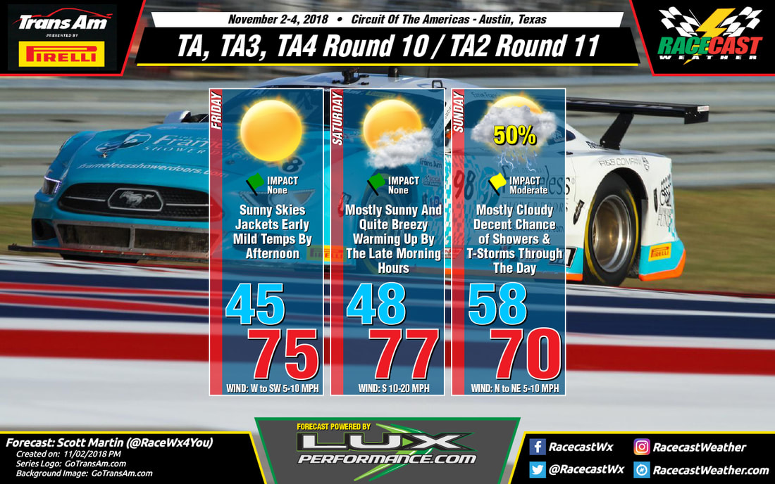
While Friday and Saturday look to be excellent weather days out at Circuit Of The Americas, Sunday is starting to look a little stormy as a shortwave will be moving through the area. The main window of showers and thunderstorms over the track on Sunday will be from 1:00 am CT through 5:00 pm CT. The good news is that the main focus of storms should occur before 6:00 am CT, with a few lingering showers possible after. Timing and chances will be adjusted as we get closer. At this point, we are going with a 50% chance of showers and storms. As far as Friday and Saturday, no worries of rain as you can expect plenty of sunshine with nice temperatures. Winds will be a little breezy at times on Saturday, possibly gusting up to 20 MPH.
Comments

Not Too Bad Weather-Wise For Trans Am At COTA: Trans Am Forecast Powered By LuxPerformance.com

10/30/2018

Comments

 
By Scott Martin.
Picture
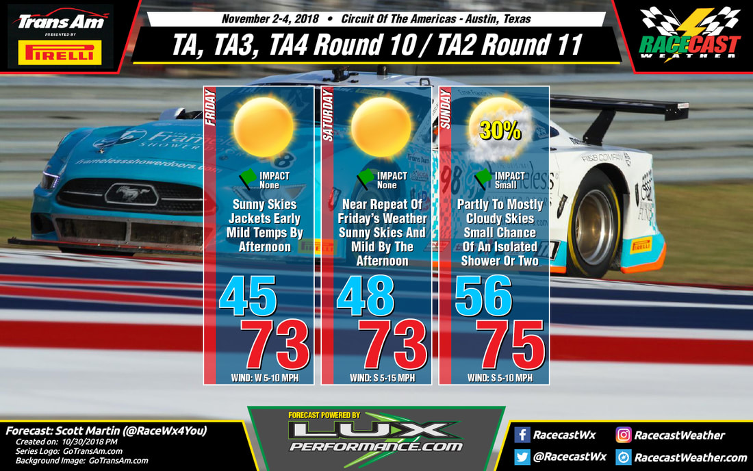
Not too much to complain about out at the Circuit Of The Americas for the next to the last event for the 2018 Trans Am Championship presented by Pirelli, unless we may have to break out the jackets for the morning sessions. Friday and Saturday will feature maximum sunshine with mild temperatures by the early afternoon hours, but early morning lows will start off in the 40s on both days. Unfortunately, I'm going to have to put a small chance of a few passing showers on Sunday as a disturbance will be moving through central and eastern Texas throughout the day, around 30% at this time. I'll be back with a forecast update on Wednesday.
Comments

Saturday's Forecast For Trans Am at VIR, Powered by LuxPerformance.com

9/22/2018

Comments

 
By Scott Martin (@RaceWx4You)
Picture
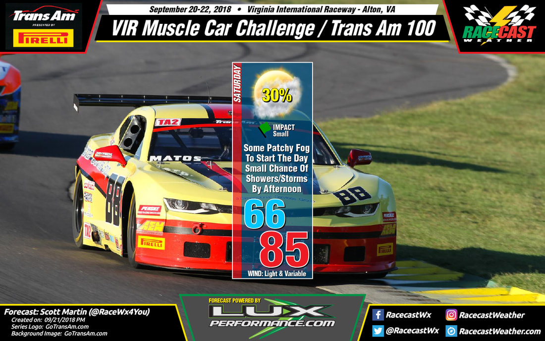
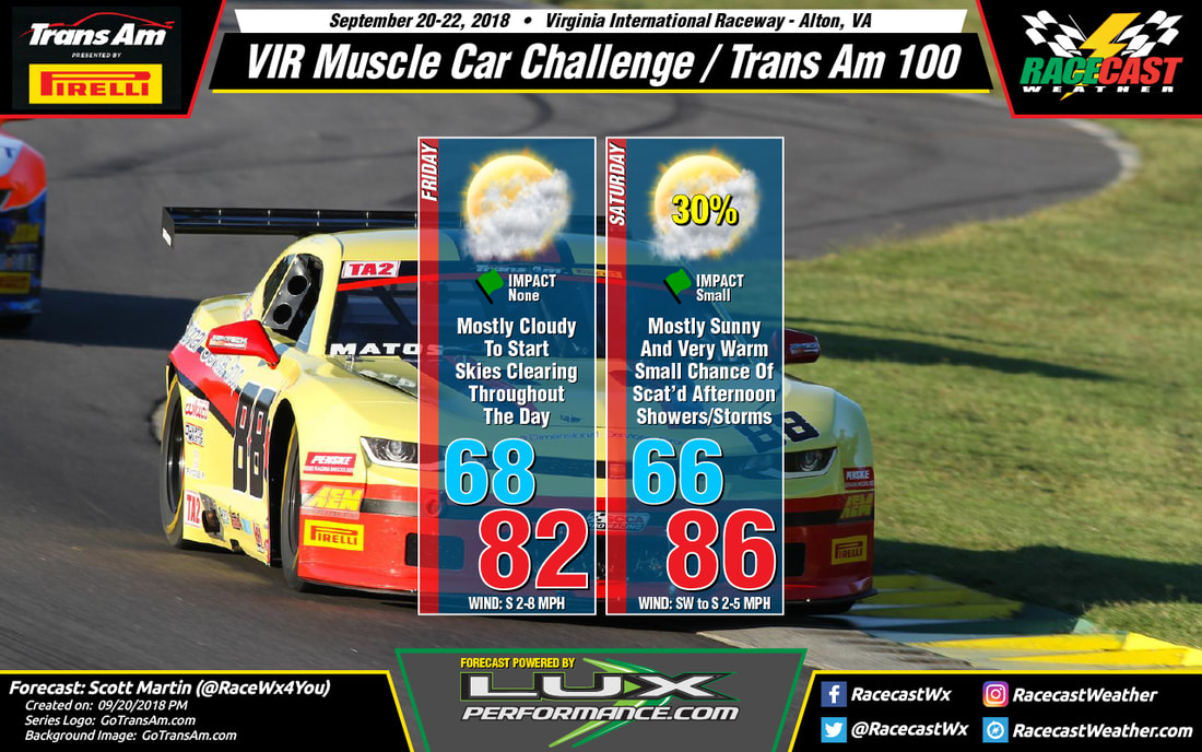
The forecast is still on track for Saturday at VIR as the dome of high pressure has been forced eastward out to see and a cold front with an associated center of low pressure makes its way towards the area. We may have some patchy fog to start off the morning, but that should quickly lift by 8:00 am or so. After that, skies will be mostly clear, but you will notice that the clouds will build in coverage throughout the day. A stray shower may be possible during the late morning hours, but I believe any rain chances will hold off until the early afternoon hours. At this point, I'm going with a 30% chance of a few scattered showers and storms during the afternoon, with the higher chances of heavier storms move in just before sunset. Afternoon highs will top out in the mid-80s and winds will be light and variable through the day. Winds are expected to pick up a little right at the beginning of the evening hours as the cold front gets closer to the area.
Comments

Forecast for Trans Am At VIR, Powered By LuxPerformance.com

9/20/2018

Comments

 
By Scott Martin (@RaceWx4You)
Picture
A big dome of high pressure will be sitting over the area on Friday, allowing the sinking air to squash any chance for any thunderstorm development throughout the day. Skies will start off mostly cloudy, with the possibility of some patchy fog during the early morning hours. The good news is that the fog will be gone by the time the cars take to the track later in the morning. Clouds will dissipate somewhat throughout the day, ending up mostly clear by sunset. Afternoon highs will top out in the lower 80s (and I may have actually been too conservative with the high as the mid-80s are not out of the realm of possibility).

Unfortunately, the high pressure gets quickly pushed off of the coast and is replaced by a center of low pressure and an associated cold front. Skies will be mostly sunny for much of the day and temperatures will be warmer as warm air will be advected into the area from the south. By the time the afternoon arrives, there will be enough lift from the approaching front and instability from the daytime heating to fire off a few scattered showers and storms. Chances will be around 30% while cars are on the track, but those will increase after sunset as the front arrives in the area. Afternoon highs will be in the mid-80s and there will be very little wind to help cool you off. Be sure to stay hydrated, wear your hats and shades, and don't forget to sunscreen up.
Comments

Trans Am at Watkins Glen Forecast, Powered By LuxPerformance.com

9/4/2018

Comments

 
By Scott Martin.
Picture
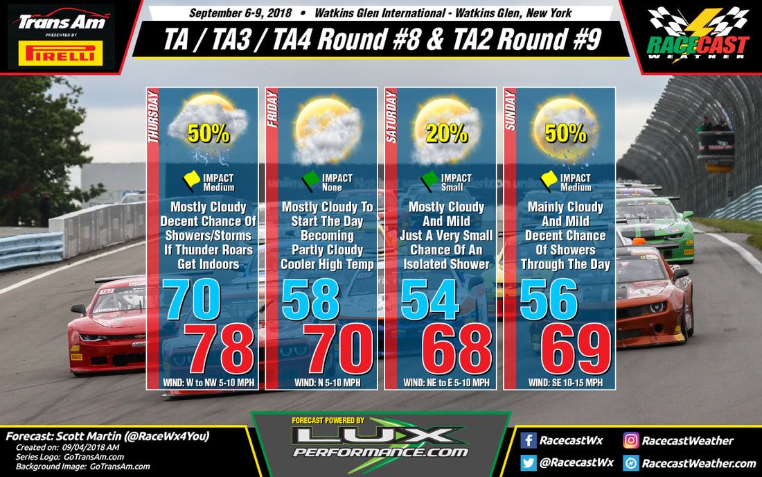
Looking at the long range models for this weekend's Trans Am event at Watkins Glen, rain will be in the forecast nearly for every day with the exception of Friday. Thursday looks to have showers and thunderstorms in the area throughout a good part of the day, with much of the activity finally moving out by the late afternoon and into the early evening hours.

Friday will be a little cooler with mostly cloudy skies and surface winds out of the north at 5-10 MPH. Saturday looks to be mainly dry, but there is a very small risk of an isolated shower during the late afternoon and early evening hours.

Sunday looks to be the wettest day of the weekend at this point, as moisture associated with the remnants of Gordon moves into and over the area. The 06z GFS showing as much as 1-inch of rain falling over the area during the morning and into the early afternoon hours, if this model pans out. Rainfall will be less in coverage after that, but still a decent chance of rain for the area.
Comments

Forecast For Trans Am At Road America, Powered By LuxPerformance.com

8/20/2018

Comments

 
By Scott Martin
Picture
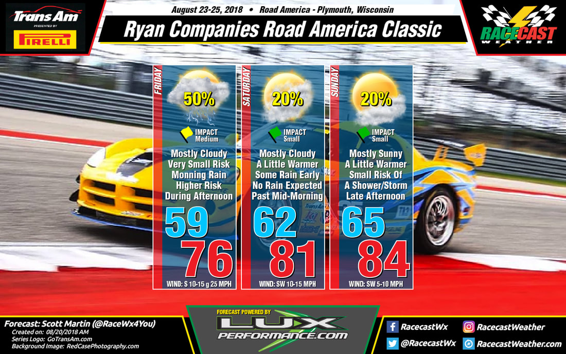
We may have some rain to deal with during the event weekend at Road America, but the good news is that the most of that will come on Friday. With that being said, there is a small chance of the wet stuff on Saturday and Sunday.

Friday will be the wettest day of the three, with a slight chance of a shower or storm during the morning hours, but with the heating of the day we'll see more showers and storms developing back to the west associated with a low. Those early showers will be isolated to scattered in nature, but the later storms will be more in coverage. Winds will be a little gusty at times as well, up to 25 MPH at times. For the most part, winds will be out of the south at 10-15 MPH. Afternoon highs will be up in the mid-70s, and the chance of rain at this point is around 50%.

At this point, it looks like the main concentration of showers and storms should be out of the area by 8AM on Saturday morning, but it will remain a little breezy and mostly cloudy. There may be a lingering shower afterwords for a couple of hours, but the chances of that are really small. Saturday's high will be in the lower 80s, with winds out of the southwest at 10-15 MPH.

Sunday will be the best looking day at the track with mostly sunny skies. With the heating of the day we could see the development of an isolated shower or storm around the area, and the chances of one passing over the track is around 20%. It will be warmer and not as breezy, with highs topping out in the mid-80s, and winds out of the southwest at 5-10 MPH.
Comments

Wednesday forecast update for Trans Am and NASCAR Xfinity Series at Mid-Ohio

8/8/2018

Comments

 
By Doug Schneider
Picture
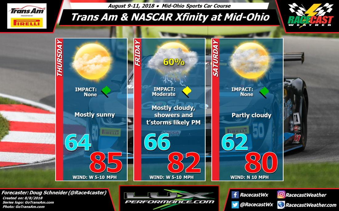
There's some good news and some bad news with the forecast update for racing at Mid-Ohio. The good news is that the chance of rain has dropped enough on Saturday that I took any mention of rain out of the forecast for that day. The bad news is that the chance of rain is looking better on Friday, up to a 60% chance. 

A cold front and an upper level trough will be moving across the upper Great Lakes on Thursday. The arrival of any storms with this front in Ohio should be late enough on Thursday evening that it should not impact any of the activity on the track that day, so I'm keeping Thursday rain-free. There may be some storms that arrive in the Mid-Ohio area in the evening, possibly as early as 8 pm. 

The front will still be in the Mid-Ohio area on Friday, and it will be the focus for numerous showers and thunderstorms to develop during the day. Coverage of showers in the morning will be scattered, with increasing coverage in the afternoon. So while there is a chance of rain at any time of the day, the afternoon hours will have the greatest chance of storms impacting the action. Rainfall amounts between a tenth and a quarter inch can be expected. Lightning will be a threat, so if you're at the track, have a plan before the storms arrive to find adequate shelter. 

The models have some differences of where the front will be for Saturday, but the majority seem to indicate that it will be south of Mid-Ohio, with drier and more stable air building in on the heels of a northerly wind flow. One model, the NAM, holds the front back and produces some showers in the area Saturday morning. I think the most likely scenario is that the showers and storms develop south of the track, and thus I'm going with a rain-free forecast on Saturday. Hopefully that pans out and there will be at least one nice weather day for racing.
Comments
<<Previous

    Social Feeds


    Instagram


    Authors

    Doug Schneider
    Scott Martin
    Stephen McCoy

    Harris Cooley 


    Partners

    Picture
    Picture
    Picture
    Picture
    Picture

    Categories

    All
    F1
    IGTC
    IMSA
    Indycar
    Le Mans
    MRTI
    NASA
    Outlooks
    Photos
    PWC
    Racecasts
    SCCA
    SRO
    Trans Am
    TUSC
    Verification
    Weather Education
    WEC


    Archives

    March 2023
    February 2023
    January 2023
    December 2022
    November 2022
    October 2022
    September 2022
    August 2022
    July 2022
    June 2022
    May 2022
    April 2022
    March 2022
    February 2022
    January 2022
    December 2021
    November 2021
    October 2021
    September 2021
    August 2021
    July 2021
    June 2021
    May 2021
    April 2021
    March 2021
    January 2021
    December 2020
    November 2020
    October 2020
    September 2020
    August 2020
    July 2020
    June 2020
    March 2020
    January 2020
    December 2019
    November 2019
    October 2019
    September 2019
    August 2019
    July 2019
    June 2019
    May 2019
    April 2019
    March 2019
    February 2019
    January 2019
    December 2018
    November 2018
    October 2018
    September 2018
    August 2018
    July 2018
    June 2018
    May 2018
    April 2018
    March 2018
    February 2018
    January 2018
    December 2017
    November 2017
    October 2017
    September 2017
    August 2017
    July 2017
    June 2017
    May 2017
    April 2017
    March 2017
    February 2017
    January 2017
    December 2016
    November 2016
    October 2016
    September 2016
    August 2016
    July 2016
    June 2016
    May 2016
    April 2016
    March 2016
    February 2016
    January 2016
    December 2015
    November 2015
    October 2015
    September 2015
    August 2015
    July 2015
    June 2015
    May 2015
    April 2015
    March 2015
    February 2015
    January 2015
    December 2014
    November 2014
    October 2014
    September 2014


Powered by Create your own unique website with customizable templates.