Racecast Weather - Your Source for Race Weather Information
  • Home
  • Racecasts
  • 2025 Schedule
  • Services
  • Contact
  • Bios
  • Links

First forecast for the WEC Six Hours of Spa

4/30/2018

Comments

 
By Doug Schneider
Picture
Picture
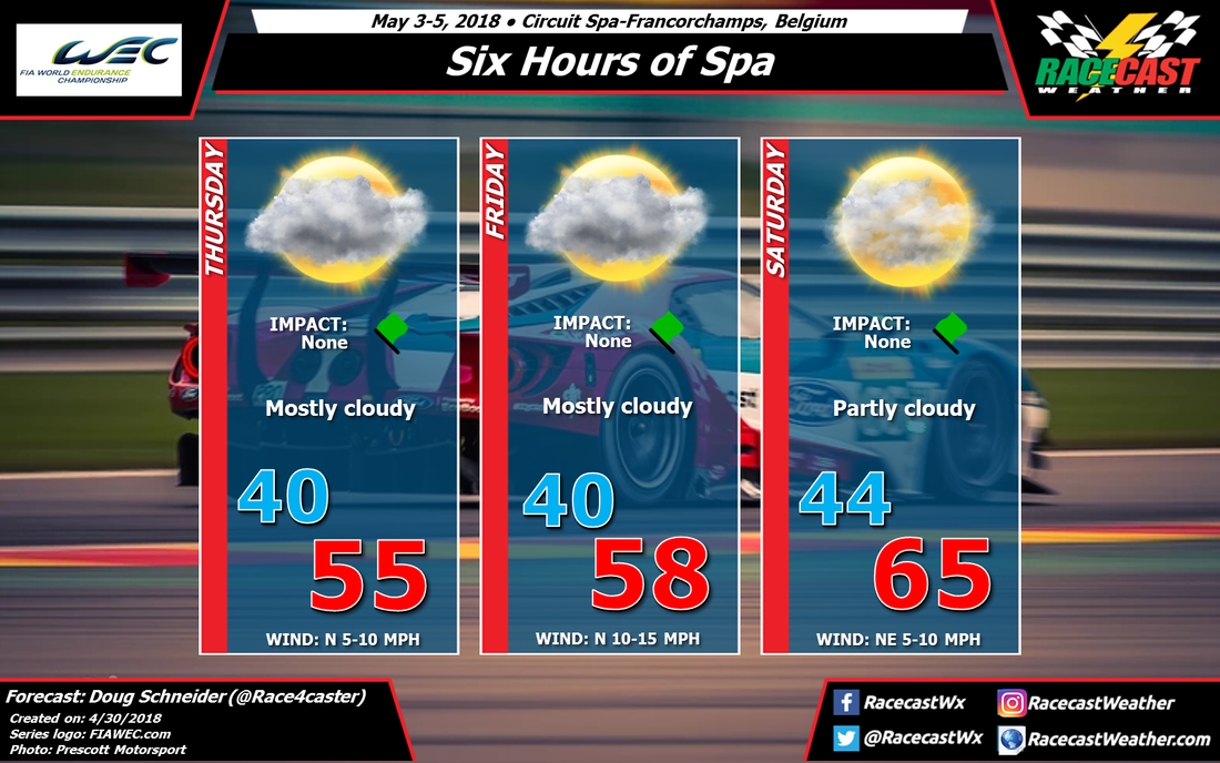
The WEC Super Season begins this weekend at the beautiful Circuit Spa-Francorchamps in Belgium. Overall, the weather looks pretty good, but there are some caveats with that.

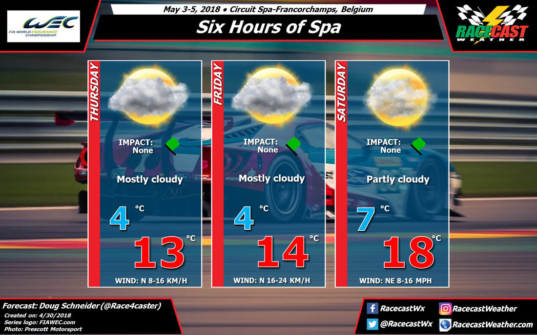
Forecasting for Belgium can be very tricky due to its proximity to the North Sea to the north and the Alps to the south, and southern Belgium has quite a varied terrain itself. The details of the weather conditions can vary greatly on a local scale, and I'm certainly not a local expert. Plus, the models are not in good agreement on the weather pattern. As a result, my confidence in this forecast is low.

The general pattern to start the event will be an upper level trough over the region, with a ridge of high pressure at the surface. The trough in the upper levels and a northerly wind at the surface will probably be enough to keep a good amount of cloud cover over the track on Thursday and Friday, but probably not enough to produce rain. This is where I'm uncertain - there's a very fine line between rain and no rain here, but I'm leaning the forecast toward no rain. The north wind will keep temperatures pretty chilly as well, with highs only in the mid to upper 50s F, or mid teens C. 

The upper level trough will be exiting on Saturday ,and surface winds should shift to a more easterly direction. This should allow for more sunshine and warmer temperatures on race day. Of the three days, I'm most confident in Saturday being dry. 

I expect this forecast will be changing through the week, and I plan to have the next update posted on Wednesday.
Comments

Wednesday forecast update: PWC Grand Prix of Virginia

4/25/2018

Comments

 
By Doug Schneider
Picture
In my first forecast for PWC's Grand Prix of Virginia at VIR, I wasn't very confident in the timing of rain chances around Friday. Now, the models have come into much better agreement, and my confidence in this forecast is higher. The upshot of this forecast is that I expect the majority of on-track activity at VIR to stay dry, which is good news for those of us who will be at the track.

On Thursday, VIR will be between an exiting storm system that is delivering some rain to the area today, and another system that will be arriving Thursday night. All indications are that the test sessions on Thursday will be run in rain-free but mostly cloudy conditions.

A low pressure system will be tracking across the Tennessee Valley region through the day, then across the Carolinas Thursday night. This system could bring quite a bit of rain to VIR Thursday night, probably around a half inch but with the potential to produce up to one inch. There may also be some thunderstorms moving through overnight. The good news is that the models are in good agreement that this system will be exiting early Friday morning, and most of the practice sessions that day should not be impacted. I have a low chance of rain and a low impact mentioned on Friday mainly due to the possibility that some of the first practice sessions of the day could be delayed a bit, and the track will likely be wet to start the day. Through the rest of the day, I can't completely rule out an isolated shower in the afternoon, but any afternoon showers will be light and brief, with no lightning expected. 

 The rest of the weekend looks to be about as good as you could hope for this time of year in Virginia. Saturday will be partly cloudy with highs in the lower 70s. A cold front is expected to move across the area Saturday evening, but it will not have enough moisture with it to produce any rain. Behind the front on Sunday, a northwest wind will bring slightly cooler temperatures, with morning lows in the mid 40s and afternoon highs close to 70. 
Comments

Forecast for the PWC Grand Prix of Virginia

4/23/2018

Comments

 
By Doug Schneider
Picture
The start of the week is going to be very wet for Virginia International Raceway, but conditions will be improving later in the week, and by the weekend, the weather should be ideal for racing.

A series of storm systems will bring quite a bit of rain to the area today through Wednesday, with up to two inches of rain possible during that time. For Thursday's practice sessions, it looks like the track will be between systems, so I expect that the practices can be held in dry but mostly cloudy conditions.

A low pressure system is expected be developing across the Southeast states on Thursday, and tracking across the Carolinas Thursday night and Friday, which could produce some showers at the track on Friday. The caveat with this is that the models are not in good agreement - one shows a stronger system that brings more rain, while another is weaker and much slower with the system, and produces very little rain. There is enough agreement on the general pattern that I have to mention a chance of rain on Friday, but my confidence is low right now. I expect the forecast for Friday will change through the week. One bit of good news is that I do not expect thunderstorms to develop with this system. 

As of today, a cold front and upper level trough will pass through the area on Friday night, with high pressure building in on Saturday. This should bring really nice weather to VIR for the weekend. Temperatures will be cooler than normal for late April, with highs around 70 on Saturday and the lower 70s on Sunday. I'm more confident about the forecast for Saturday and Sunday, as the models are in better agreement and have been fairly consistent about dry weather those days.

I'll be attending the race and providing weather support for the track during the event, so I'll be keeping a close eye on the forecast through the week. Stay tuned for updates.

Thanks to Joseph Bierschbach for providing us with his beautiful photos for our forecast graphics. Check out his work at redcasephotography.com.
Comments

Honda Indy Grand Prix of Alabama Postponed Until Monday At 11:00 AM

4/22/2018

Comments

 
By Scott Martin.
Picture
Rain has plagued Barber Motorsports Park throughout the day on Sunday and it is now to the point where the track is unrecoverable for the day and rainfall is still occurring. The Verizon Indycar Series race control has made the decision to stop the race after 22 laps of the scheduled 90.

As of the weather station located on the roof of the race control building, we have received almost 0.40 inches of rain throughout the day so far (as of 5:00 PM).

Looking at the forecast for Monday, we’ll have mostly cloudy skies once again at the track with a chance of a passing shower or two. The good news is that rain chances are much less than today, but high enough that rain tires may be needed again. Forecast models are varying on the rainfall for Monday… from none at all by the NAM, to a very small amount by the GFS, to a higher risk of rain by the European. At this point, we’ll go with 50/50 odds.

The temperature to start off the day will be in the upper 50s and the afternoon high will top out in the upper 60s. Winds will be out of the south-southwest at 5-10MPH. If any rain falls at the track, it should only amount to less than 0.15 inches.
Comments

It's Race Day At The Honda Indy Grand Prix of Alabama

4/22/2018

Comments

 
By Scott Martin.
Picture
Picture
Radar at 7:25 AM
So far this morning we are staring off with scattered showers and storms to our north, and those will continue to head in a northeasterly direction. What we will have to watch for is the development of any showers or storms to our southwest.
Picture
HRRR Simulated Radar Throughout The Day
The latest HRRR run shows a decent dry slot over the track from 9:00 AM to 11:00 AM before more scattered showers move in ahead of a large rain mass. The good news with that rain is most of it stays light to moderate throughout the afternoon until you get around 2:00 PM before much heavier rainfall moves in. This is when we'll have a higher chance of thunder, but that threat still remains rather low at this point. Rainfall amounts before midday will be around 0.20 inches, but from midday to around 7:00 PM we could see up to 0.75 inches or more. We still could see delays this afternoon due to heavy rainfall.

There is no threat for severe weather today at the track, but there is a marginal risk for severe storms well off to the south. Like I said earlier, we may have some thunder. Please stay weather aware throughout the day, and heed the call from the PA if a weather alert is announced at the track. A good rule of thumb to remember... if you can hear thunder, you're close enough to the storm to be struck by lightning.

Another issue that we'll have to worry about is higher winds. NWS Birmingham has a Wind Advisory that will go into effect this afternoon at 1:00 PM for the area and will expire at 4:00 AM Monday. Winds will be averaging 15-25 MPH during that time with gusts up to 35 MPH. We could see gusts up to 40 MPH on top of the hills above the paddock area since the wind will be stronger in higher elevations.

So let's cross our fingers and hope that we can catch a break so we wouldn't have to wait until Monday to get the race in. The good news is that if we do have to wait until Monday, the forecast is much better with only a chance of showers from the back side of the system.

Radar will be up and running throughout the day on RacecastWeather.com.
Comments

Honda Indy Grand Prix of Alabama Race Weekend Has Arrived… Here’s The Saturday Update

4/21/2018

Comments

 
By Scott Martin.
Picture
Conditions At Barber Motorsports Park At 10:30 AM
We have bright sunshine currently at the track for the second day of on-track activities of the Honda Indy Grand Prix of Alabama weekend. Temperature is currently at 60 degrees and winds are averaging around 10 MPH at this point. There is no rain in the area and will continue that way for the remainder of the racing day at the track.

Weather For The Remainder Of The Day At The Track
Beautiful weather continues throughout the remainder of the afternoon and into the early evening hours. We'll start off with mainly clear skies at the midday hour, but clouds will be on the increase throughout the afternoon hours which will probably bring some relief to those who may have gotten sunburned. Winds will be out of the east-southeast at 8-12 MPH, and the afternoon high tops out in the mid-70s. No rain today, but showers will move into the area around or just after midnight.

Sunday's Weather At The Track
The latest high-resolution model runs continue to show rain and a few claps of thunder possible throughout the day at Barber Motorsports Park. Rain will be scattered in nature to start the day, but those will become more numerous in nature by the afternoon hours. The good news is that there will virtually be no instability over the area, but there may be some gusty winds possible at times. Those winds will be out of the east-southeast averaging 10-15 MPH with gusts up to and possibly over 25 MPH. Unfortunately, rainfall also will be the heaviest throughout the afternoon and evening hours, with over 1.50 inches possible on Sunday. I may not be well-liked after I say this, but rain tires will be likely and rainfall could be so heavy that delays will be possible. Temperatures will start off in the mid-50s at daybreak and only climb into the mid-60s by the afternoon. Stay weather aware if you are at the track. If you hear thunder, you are close enough to the parent storm to be struck by lightning.
Comments

Honda Indy Grand Prix of Alabama Race Weekend Has Arrived… Here’s The Friday Update

4/20/2018

Comments

 
By Scott Martin.
Picture
Friday’s Weather
It is a cool and breezy day to start off with out at Barber Motorsports Park with temperatures currently at 53 degrees and a breeze at 13 MPH as of 11:20 AM. Skies are completely clear and you could not ask for a better day weather-wise. Afternoon highs are still expected to top out in the upper 60s to close to 70 degrees. Winds will continue to be breezy throughout the day at 5-15 MPH out of the east-northeast.

Saturday’s Weather
It will be a fantastic day out at the track for qualifying and races as we’ll have comfortable temperatures with mainly sunny skies. Clouds will start to move in during the late afternoon into the early evening hours, but we’ll stay dry during the on-track times. Morning lows will start off in the mid-40s and will warm into the lower 70s for the daytime high. Winds will be out of the east-southeast at 4-12 MPH. No rain is expected throughout the entire day as the system will hold off until around midnight before rain chances start to increase.

Sunday’s Weather
At this point, it looks like Sunday will be pretty wet at times with showers and a few thunderstorms possible at any time throughout the day. The good news is that severe weather is not likely, but rainfall amounts could get up as high as 1/2 inch during the daylight hours. Rain tires will definitely be needed a few times throughout the day, but there will be breaks in the rain and we could have some periods where the track dries out some… especially during the late morning hours. Temperatures start off in the mid-50s, and the afternoon high will be in the mid-60s. Winds will be quite breezy averaging 10-15 MPH out of the southeast.

Comments

Thursday Forecast Update For Honda Indy Grand Prix of Alabama

4/19/2018

Comments

 
By Scott Martin.
Picture
Friday's Weather
Friday will definitely be a great day in Birmingham to greet the fans and teams at Barber Motorsports Park for the first day of the Honda Indy Grand Prix of Alabama event weekend. After starting off rather chilly near 40 degrees in the morning at daybreak, skies will be sunny throughout the day, and highs will top out in the upper 60s to near 70 degrees. Winds will be out of the east-northeast at 5-12 MPH, and there is no chance of rain.

Saturday's Weather
It will be a fantastic day out at the track for qualifying and races as we'll have comfortable temperatures with mainly sunny skies. Clouds will start to move in during the late afternoon into the early evening hours, but we'll stay dry during the on-track times. Morning lows will start off in the mid-40s and will warm into the mid-70s for the daytime high. Winds will be out of the east-southeast at 4-10 MPH. A few scattered showers are possible during the late evening through the overnight hours, but thunderstorms are unlikely at this point. Just may have the pitter-patter of raindrops hitting the tops of the tents and campers on the grounds.

Sunday's Weather
Sunday's weather at Barber Motorsports Park unfortunately still looks pretty wet with the North American Mesoscale (NAM) model now in play throughout the weekend. Scattered showers look to be possible to start off the day, but the better risks for storms move in during the early parts of the afternoon and persisting through the early evening hours. A center of low pressure will be located in east-central Arkansas to start the day and will move into northern Mississippi by early evening. Out ahead of the cold front that will be associated with that low, surface instability values will be in the 900-1200 J/kg range, so lightning will be possible. I'll have to wait one more day for the high-resolution NAM model comes into play to see what and if there will be any severe risks.

At this point, the Storm Prediction Center does not have any severe weather risk areas defined for the area on Sunday. Plus, the GFS and European models have come into much better agreement so rain will now be likely. Winds will be out of the east-southeast averaging 8-12 MPH. Skies will be mainly cloudy throughout the day when it's not raining, and rain chances are now up to 100%. The morning will start off in the mid-50s and will only warm into the upper 60s for the daytime high. I hate to say it... it looks like delays are possible on Sunday.
Comments
<<Previous

    Social Feeds


    Instagram


    Authors

    Doug Schneider
    Stephen McCoy

    Harris Cooley 


    Categories

    All
    F1
    IGTC
    IMSA
    Indycar
    Le Mans
    MRTI
    NASA
    Outlooks
    Photos
    PWC
    Racecasts
    SCCA
    SRO
    Trans Am
    TUSC
    Verification
    Weather Education
    WEC


    Archives

    February 2025
    January 2025
    December 2024
    November 2024
    October 2024
    September 2024
    August 2024
    July 2024
    June 2024
    May 2024
    April 2024
    March 2024
    February 2024
    January 2024
    December 2023
    November 2023
    October 2023
    September 2023
    August 2023
    July 2023
    June 2023
    May 2023
    April 2023
    March 2023
    February 2023
    January 2023
    December 2022
    November 2022
    October 2022
    September 2022
    August 2022
    July 2022
    June 2022
    May 2022
    April 2022
    March 2022
    February 2022
    January 2022
    December 2021
    November 2021
    October 2021
    September 2021
    August 2021
    July 2021
    June 2021
    May 2021
    April 2021
    March 2021
    January 2021
    December 2020
    November 2020
    October 2020
    September 2020
    August 2020
    July 2020
    June 2020
    March 2020
    January 2020
    December 2019
    November 2019
    October 2019
    September 2019
    August 2019
    July 2019
    June 2019
    May 2019
    April 2019
    March 2019
    February 2019
    January 2019
    December 2018
    November 2018
    October 2018
    September 2018
    August 2018
    July 2018
    June 2018
    May 2018
    April 2018
    March 2018
    February 2018
    January 2018
    December 2017
    November 2017
    October 2017
    September 2017
    August 2017
    July 2017
    June 2017
    May 2017
    April 2017
    March 2017
    February 2017
    January 2017
    December 2016
    November 2016
    October 2016
    September 2016
    August 2016
    July 2016
    June 2016
    May 2016
    April 2016
    March 2016
    February 2016
    January 2016
    December 2015
    November 2015
    October 2015
    September 2015
    August 2015
    July 2015
    June 2015
    May 2015
    April 2015
    March 2015
    February 2015
    January 2015
    December 2014
    November 2014
    October 2014
    September 2014


Powered by Create your own unique website with customizable templates.