|
By Scott Martin Race weekend falls into a slightly unsettled weather pattern for Central Alabama. There will be plenty of moisture available, but with the cool to mild temperatures, rain coverage on each day will be isolated, which will keep chances small. Friday, for now, looks to have the higher rain chances for the whole weekend as there will be a storm system exiting the area on late Thursday to early Friday. Some leftover showers will be what we may have to deal with. A trough is expected to send a disturbance into the northern portions of Alabama on Saturday that will keep a small chance of showers and maybe a thunderstorm in the forecast, but that should be out of the area by Sunday afternoon. Only keeping a very small shower chance in the forecast in case that system hangs around a little longer. The forecast will be refined through the week.
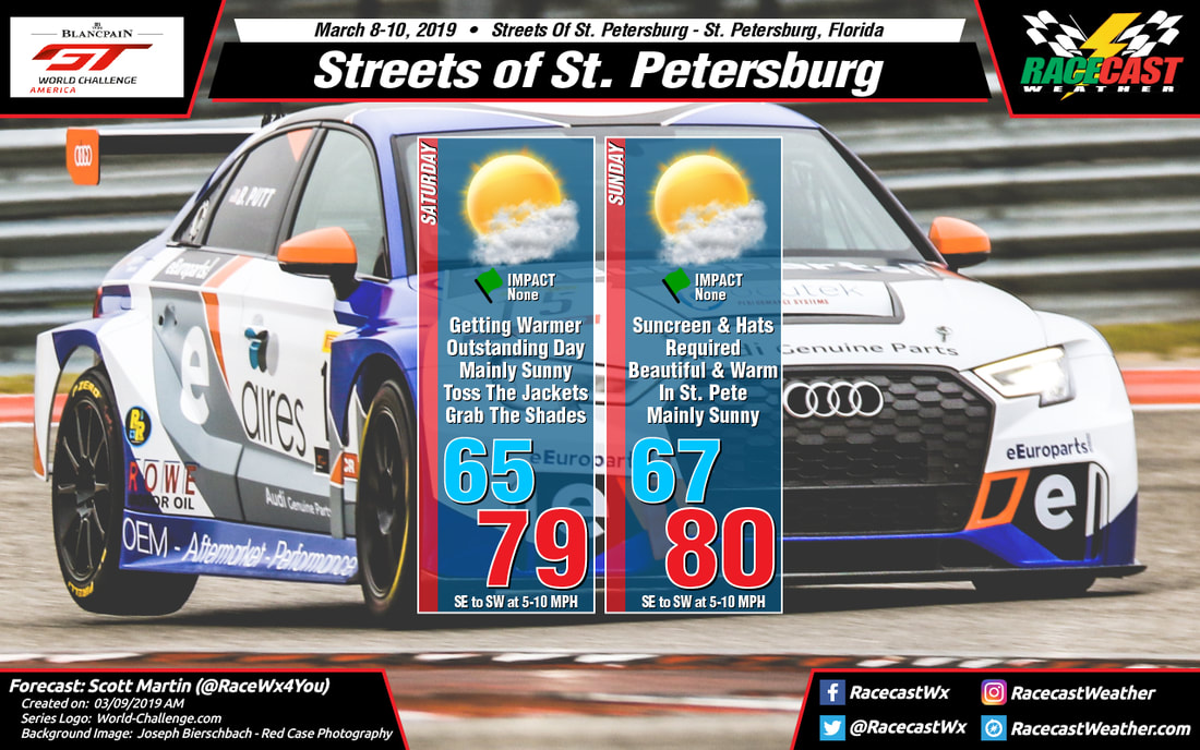
By Scott Martin First of all, I want to apologize to the sports car fans for leaving out the graphics for the Blancpain GT World Challenge America series for this weekend's event at St. Petersburg. It's been a tough week in the weather office for me as we in Central Alabama are recovering from severe storms that swept through the area last weekend and gearing up for the potential of more severe storms this weekend.
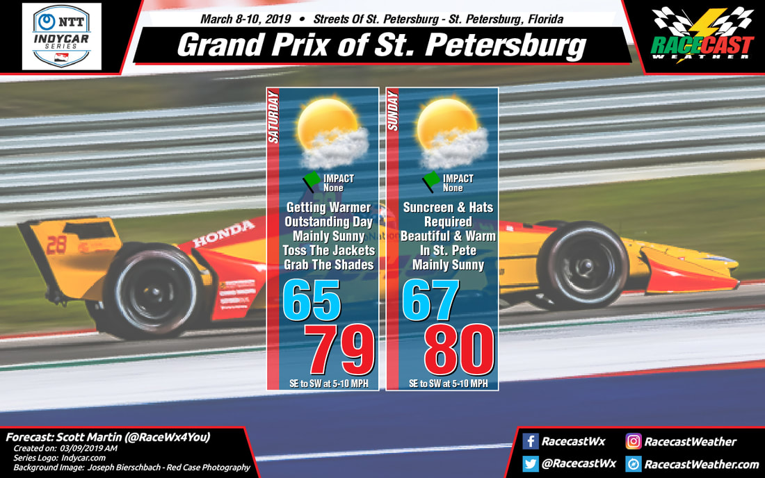
The good news for St. Petersburg is that conditions probably could not be any better as we'll see plenty of sunshine with just a few passing clouds on both days. Highs will be approaching 80 degrees with morning lows starting off in the mid to upper 60s. Wind on both days will start off out of the southeast at 5-10 MPH but will eventually shift out of the southwest by the afternoon hours. This will be the last forecast update for this event unless there are drastic changes that need to be made to the forecast. No radar on the site this weekend as well as I'll be utilizing it for severe weather coverage in Central Alabama. By Doug Schneider The timing of the rain chances along a cold front has shifted a little later with this forecast update, but any rain that falls is not expected to have an impact on the racing activities.
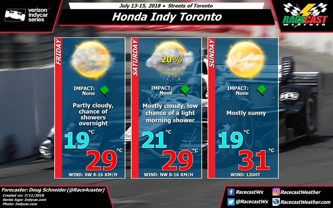
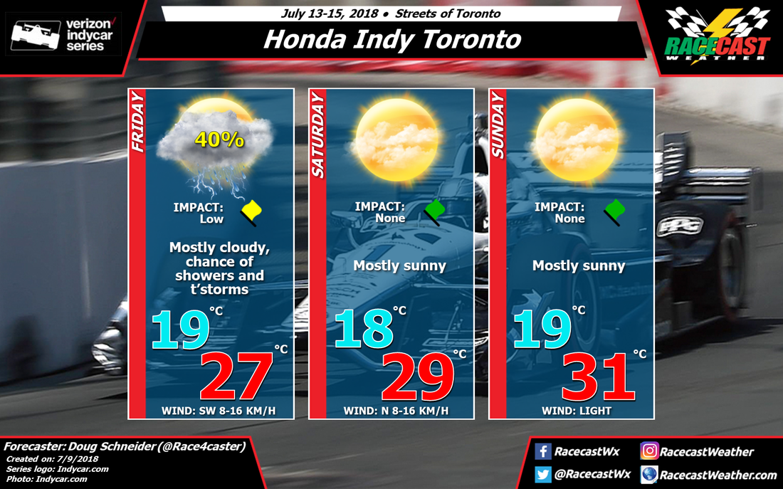
The models have started to come into better agreement on the timing of rain being mainly on Friday night. I expect that rain won't fall in Toronto until after sunset, well after the end of any on-track activity on Friday. With the later arrival time for rain chances, Friday should have more sun and temperatures should reach the mid 80s. As I mentioned in the previous forecast, any rain is expected to be pretty light and scattered, and that is still the case. The front should move through the area early Saturday morning, and a light shower or sprinkle could be possible after sunrise. As a result, I have just a slight chance of rain mentioned for Saturday morning, with no impact expected on the racing. If rain does fall on Friday night and Saturday morning, I expect it will be around a tenth of an inch or less. High pressure through the lower and mid levels of the atmosphere will build over the Great Lakes region for Sunday, which will bring warm temperatures and plenty of sunshine.Highs on Sunday afternoon are still expected to reach the upper 80s, with light winds. By Doug Schneider IndyCar has had a string of races with great weather, and it looks like that will continue this weekend on the streets of Toronto. There may be some showers and storms around on Friday, but the weather looks nice for the rest of the event.
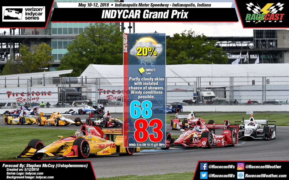
On Thursday, high pressure from the surface through the midlevels will be over the Great Lakes region, drifting toward the southeast, as a low pressure trough and cold front move across the Northern Plains and south-central Canada. This approaching system will bring a chance of rain to the Toronto area on Friday and Friday night. It does not appear to be a very strong system, and the rain probably won't be heavy or last for very long, but there are some timing uncertainties this far out in the forecast. It could arrive as early as Friday morning or as late as Friday evening. Later updates will pin down the timing a little more. Another high pressure ridge builds in behind the departing trough, and will provide mostly sunny and warm conditions for Saturday and Sunday. Highs both days will be in the mid to upper 80s. One thing to keep an eye on will be if the Friday/Friday night system slows down even more than the models currently show, and rain continues into Saturday morning. I think that is unlikely at this point, so I am keeping Saturday completely dry with this initial forecast. By: Stephen McCoy The warm front mentioned in the previous discussions will continue to be centered horizontally east-to-west over the Midwest. This is expected to set up a very strong temperature gradient over central Indiana, having a 20F degree difference in temperature in about 50 miles. Thankfully, Indianapolis Motor Speedway is expected to be on the warmer side of the warm front. During the day, the front is expected to push slowly southward and will bring a chance for isolated thunderstorms to central Indiana during the afternoon. A small shortwave trough in the upper atmosphere and winds from the south and southwest in the lower levels will help contribute to this chance. The Storm Prediction Center has Indianapolis under a Slight Risk (level 2 of 5) for severe storms, but this could change depending on the exact location of the warm front. So, be sure to stay weather aware if at the track, since these pop-up storms could be hit-or-miss. Expect winds from the south to southwest around 10-15 mph with gusts around 25 mph.
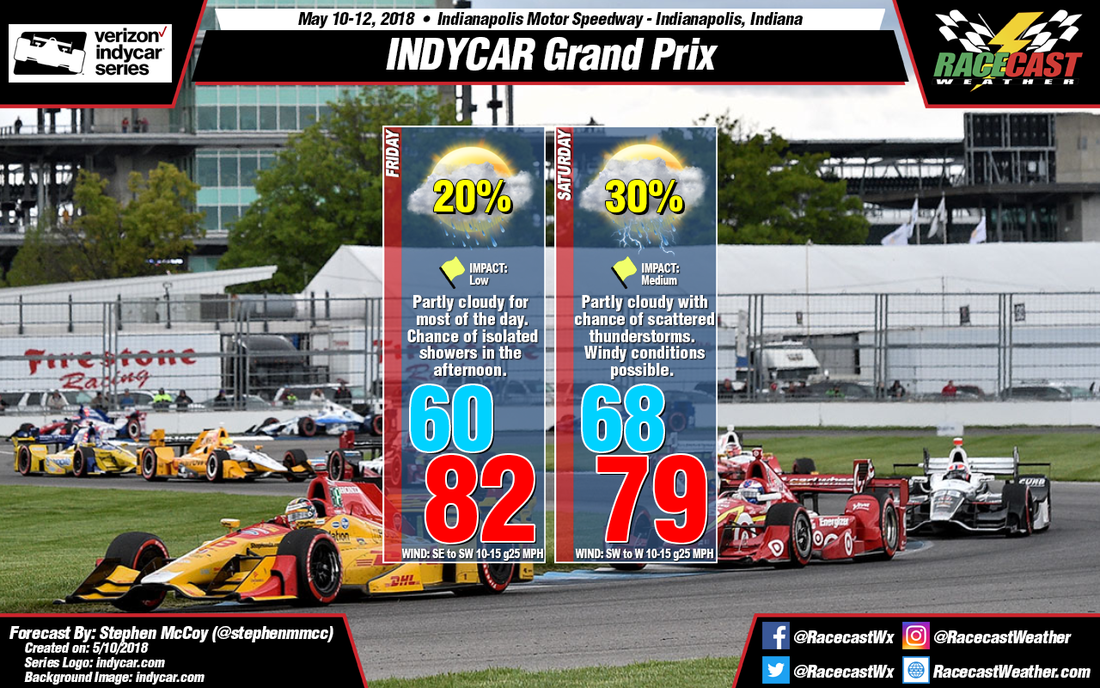
By Stephen McCoy If you are at the track either day, it might be a good idea to bring an umbrella just in case as both Friday and Saturday have a chance of isolated to scattered rain.
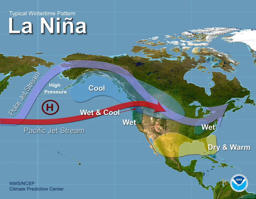
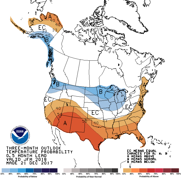
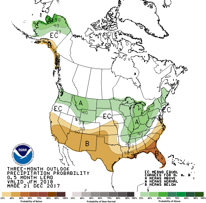
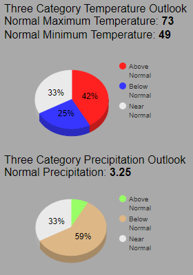
Initial winds in the morning will be out of the northeast and east, bringing some cooler temperatures before swinging to the south and southwest with the approach from a warm front. Surface winds and winds in the lower portion of the atmosphere are expected to align in the same direction, causing winds around 15-20 mph with some stronger gusts approaching 25-30 mph. The warm front is expected to move through central Indiana mid-day, causing rain to the North and West of Indianapolis. However, depending on exact placement of the front in the afternoon and evening, coupled with daytime heating, it could bring a few isolated showers into central Indiana and has a low chance of affecting on track activities. With the passage of the warm front, expect warmer temperatures in the upper 60’s in the morning. As the day progresses, winds continuing from the south and southwest will bring temperatures into the upper 70’s. Wind speeds are expected to remain constant through the forecast period at around 10-15 mph with gusts at 25-30 mph. The Storm Prediction Center currently has a Marginal Risk of storms (level 1 of 5) stretching from Iowa through West Virginia and includes much of central Indiana. There is a chance of scattered thunderstorms that could affect the races held in the early afternoon. Look for a more definitive outlook in the next update. By Doug Schneider - @Race4caster The start of the 2018 racing season is almost here! The seasons for IMSA, NASCAR, Trans Am, Pirelli World Challenge, and IndyCar all open in the state of Florida during January, February, and March. So I decided to take a look at what the long term weather outlook is for those months. A couple years ago, I wrote a post about long term weather forecasting, and I encourage you to take a look at that to get a better idea of what goes into making a long term forecast, and what the limitations are. It's foolhardy to try and pinpoint specific details about the weather more than 10 days in advance, but it is possible to predict the general weather pattern and the likelihood of temperature and precipitation being above or below normal. The Climate Prediction Center has forecasters that make monthly and seasonal forecasts, and I will be using their forecasts here. One important factor in making a long term forecast is to know what the ENSO cycle will do. What's ENSO, you ask? It stands for El Niño-Southern Oscillation (for more information about it, see this post). Whether there is an El Niño or a La Niña in the Pacific will have an impact on the dominant position of the jet stream, which impacts the weather pattern across North America. Currently, La Niña conditions are observed in the Pacific, which is expected to persist through the winter. What does that mean for Florida? Typically, La Niña conditions produce warmer-than-normal temperatures and drier-than-normal conditions across Florida during the winter: As a result of the La Niña conditions likely continuing through March, the forecasters at the Climate Prediction Center are expecting temperatures above normal (left image) and precipitation below normal (right image) for Florida in the Jan-Feb-Mar time frame (click it to big it): The color scales at the bottom of the images are essentially confidence levels. So for example, the more confident the forecaster is that below normal precipitation will occur for those three months, the higher the probability on the color scale (darker brown). Daytona is the the 40-50% probability area for above normal temperatures, and in the 50-60% probability area for below normal precipitation. Here's another way to think of it. There are three equal possibilities - conditions near normal, above normal, or below normal. So this is what the forecast above looks like visualized as a pie chart for Daytona: - Visually, that makes more sense to me. Of the three possible outcomes, the most likely is that temperatures will be above normal (42% chance), and precipitation will be below normal (59% chance).
While this forecast is no guarantee of warm and dry race weekends, I'd say it is good news for race fans who plan to attend these events in Florida. Keep in mind that this forecast covers a period of three months, and the five race weekends (Rolex 24, Daytona 500, TA at Sebring, 12 Hours of Sebring, GP of St. Pete) are only 10 days out of 90. So those 10 days could all be cold and rainy, while the other 80 days could be warm and dry, and the long term forecast for Jan-Feb-Mar would still be accurate. But there would be a lot of unhappy race fans. We'll have the detailed forecasts for these races (except the Daytona 500 - we leave that to @NASCAR_WXMAN) posted here at RacecastWeather.com a week before the race is run. You can see our entire schedule of race forecasts at the 2018 Schedule link at the top of the website, and be sure to follow all of our social media feeds - we're on Twitter, Facebook, and Instagram. By Scott Martin - @RaceWx4You The weekend forecast for Road America at this point doesn't look too bad, but we may have to put up with a little wet stuff at some points throughout the event. Believe it or not, the tropical system that is affecting the Gulf Coast is messing with the forecast, so some of the details are not set in stone as of yet. I'll nail those down within the next day or two.
There is a surface boundary that is forecast to stall out over the Wisconsin/Illinois border, and this may bring showers and thunderstorms to the area on Thursday, especially during the afternoon hours. There is a possibility that the weather on Wednesday could make the storms form farther to the south on Thursday, we'll just have to wait and see on that part. By Friday, all of the shower activity will have moved out of the area, and the day is setting up to be nice and dry with mild temperatures. We'll have a slightly active weather pattern setting back up over the area for Saturday as troughing starts to form and begins to move near the area. This will allow several waves to move through the area, but as of now, rain chances will be small and mainly during the afternoon hours. Same story on Sunday, but rain chances will be even smaller, and I wouldn't be surprised if I will be able to remove those rain chances out of the forecast within the next day or two. Bottom line: We'll mention the chance of rain on both Saturday and Sunday, but more than likely it will stay dry at the track. I'll have a really good idea by Wednesday night on what the weather will hold for us at Road America. |
Social Feeds
Authors
Doug Schneider Partners
Categories
All
Archives
December 2023
|

