|
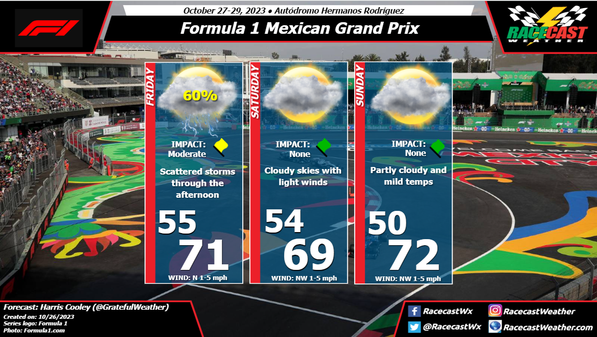
By: Harris Cooley The race weekend will be starting off a bit rainy as upper level winds are conducive of storm development. Mostly scattered storms in the area but should be fast moving. The next two days will be partly cloudy with light northerly winds keeping tracks temps cool. The temps wills be warm in the afternoons as high pressure sets in over the area. Overall, mostly nice conditions for race day. A metric graphic is below...
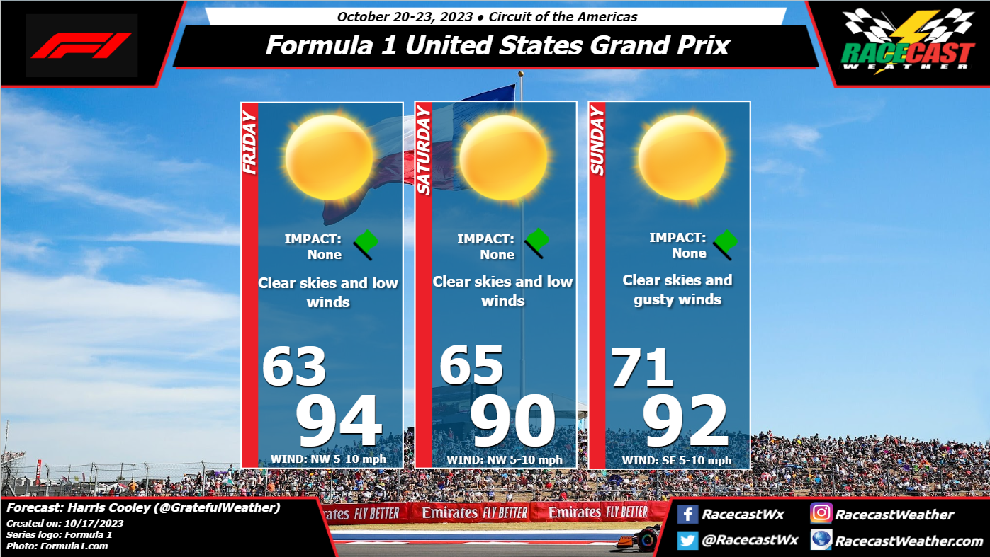
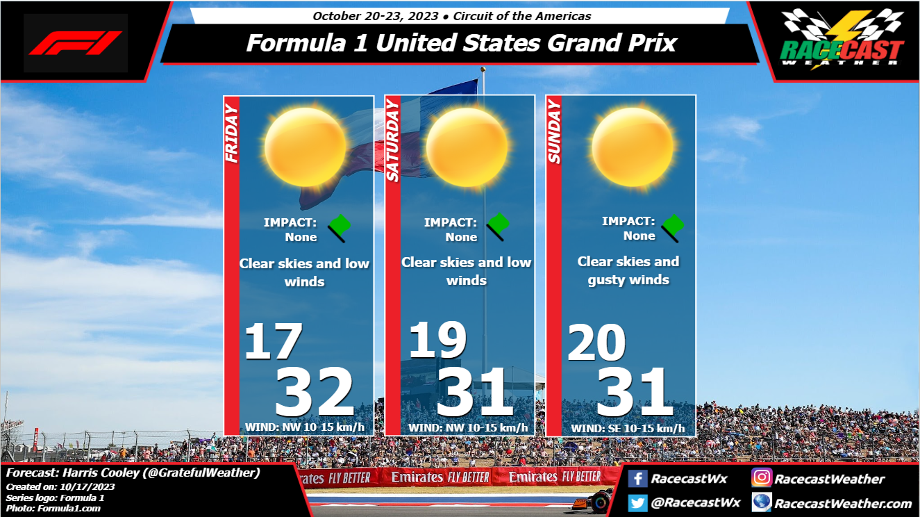
By: Harris Cooley Conditions could not be better for the US GP in Austin, TX this weekend. A weak cold front will be passing early Friday morning bringing dry air and low winds behind it. There are no chances for rain with this front as skies will be clear and moisture will be low. Teams will need to prepare for increased track temps during the day as the sun will quickly heat the surface. Ambient temps will feel quite pleasant for the patrons though. There are not many threats from the atmosphere for the drivers this weekend. A metric graphic is pasted below...
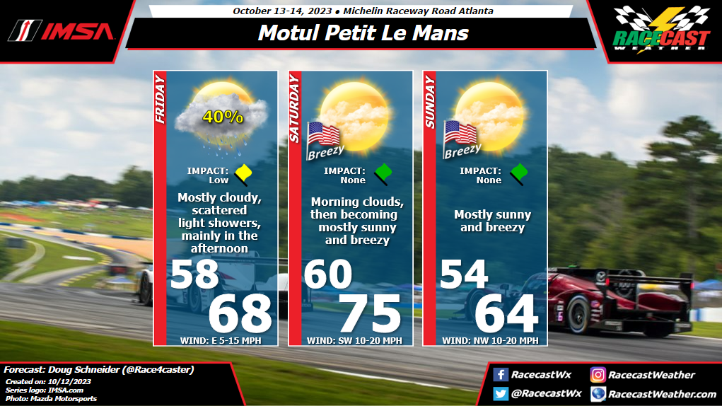
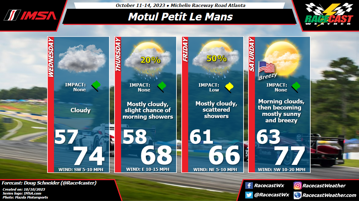
By Doug Schneider Today's update brings some good news for those attending Petit Le Mans. The rain that is expected on Friday is looking less impactful, with lower amounts during the day and slightly later timing.
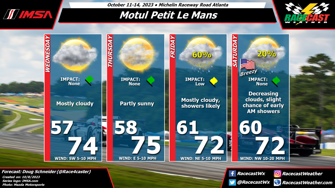
A weak low pressure system through the mid and upper levels of the atmosphere will be crossing Georgia on Friday and Friday night. I am feeling more confident about this forecast than my last update, because the models are coming into better agreement about this system. I expect that sprinkles or light showers will begin around midday, and be on and off through the afternoon. It does not look like it will be heavy enough to cancel or delay any racing, but the MPC race and WeatherTech qualifying could be interesting, with the potential need for wet tires if a shower persists long enough. The bulk of the rain with this system is now expected to move through Road Atlanta on Friday night, and exit around sunrise on Saturday morning. Saturday continues to look like a beautiful day for racing. The day will start with mostly cloudy skies, but it will become mostly sunny by the afternoon. Along with the sunshine, a southwest wind at 10 to 20 mph will bring mild temperatures reaching into the mid 70s. Temperatures around the end of the race will be in the lower 60s. For the campers, lows on Saturday night will drop to the mid 50s. Sunday will have mostly sunny skies, a breezy northwest wind, and highs in the mid 60s. I'll be at the track tomorrow so this is my last update. I'll try to post some radar updates on our Twitter account if possible. By Doug Schneider I will say up front that I don't have high confidence in this forecast. There are a lot of places where this forecast could be a bust. Even today, the models are showing very different scenarios that could happen with the weather on Wednesday, Thursday, and Friday, particularly in regard to how much rain might fall. This forecast is my best estimate, and I'm leaning toward a more positive (drier) outlook. However, I may be biased because I'll be attending the race.
The tricky part of the forecast for Wednesday and Thursday is a tropical low pressure system that will be tracking east along the Gulf Coast region. While the low will stay well south of Road Atlanta, moisture from the Gulf is expected to spread northward across Georgia. On Wednesday, I think it will be mainly cloud cover, with no rain expected. However, rain may spread into the area Wednesday night. This would impact campers at the track, but I expect the rain to be gone by the time track activates begin on Thursday morning. Some models hang onto some rainfall through the daytime Thursday, but most clear out the rain and some of the clouds. The small chance of rain in my forecast is just for the early morning hours, and I think it will be mainly a dry day with some sunshine breaking through in the afternoon. An upper level disturbance is expected to cross the area on Friday, but there are big differences between the models in regard to how much rain it produces. Some produce no rain, others produce an inch or more. I think there's a good chance of seeing some rain on Friday, but I lean toward the models that show only light amounts, given how fast this disturbance moves through and the weak lift that it produces. I think rain amounts between a tenth and a quarter inch is the most likely scenario. On Saturday, there may be some clouds to start the day as the disturbance exits to the east, but clouds will decrease through the day. Mostly sunny skies and a breezy southwest wind will warm temperatures into the mid to upper 70s. A cold front will be approaching from the west, and will cross the area Saturday evening. Winds will shift to the northwest, and temperatures Saturday night will fall into the lower 50s. I plan to have another forecast update posted on Thursday afternoon. By Doug Schneider Much of the Southern Appalachian region has been very dry and in need of rain over the past few weeks. Unfortunately, it looks like rain is likely to arrive over Petit Le Man weekend. The good news for race-goers is that the rain is not expected to be very heavy, and that it should move out before the start of Saturday's race.
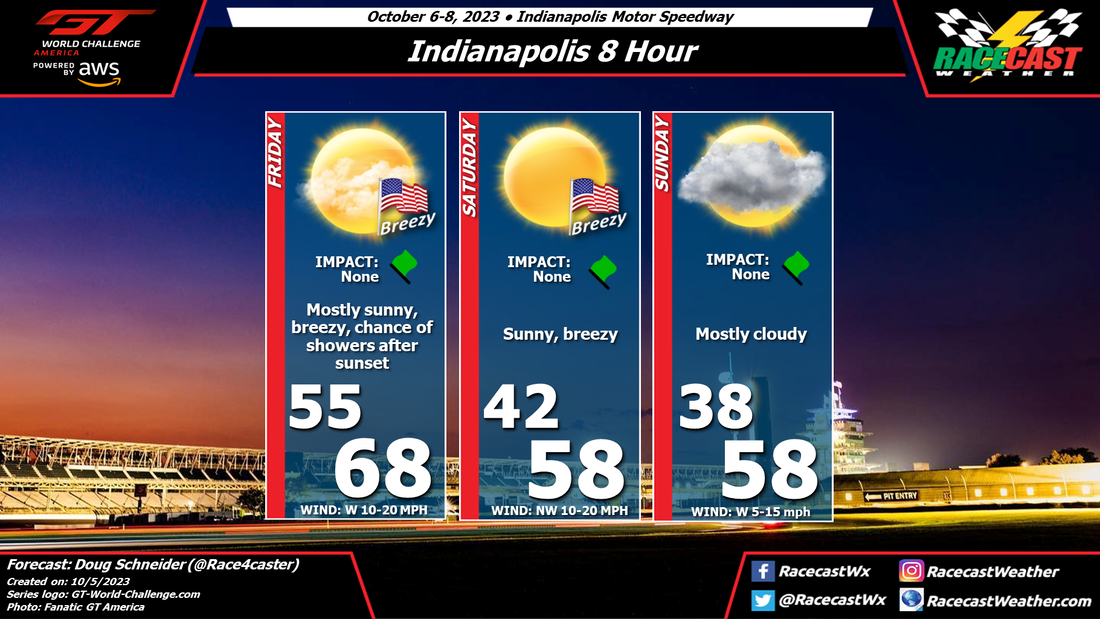
On Wednesday, a low pressure system will be tracking along the Gulf Coast region. The rain associated with this system will stay well south of Road Atlanta, but it will bring quite a bit of cloud cover during the day. Highs will be pleasant, in the mid 70s. Thursday is expected to see more sunshine than Wednesday, with similar high temperatures in the mid 70s. On Friday, a cold front will be approaching from the northwest. Ahead of the front, moisture will increase across Georgia, and some light rain will likely move in before sunrise. On and off showers are expected through the day, but most of these will be light. Rain amounts are uncertain this far out, but I expect perhaps a few tenths of an inch by Friday evening. The timing of the cold front will determine when the chance of rain ends. At this time, I expect the showers to exit by sunrise, but there is a possibility that they could linger into the mid to late morning hours. The morning practice session could be affected. The rest of Saturday looks great, with a high in the lower 70s and mostly sunny skies by the afternoon. Saturday night will get chilly for those camping out, with a low around 50. Check back through the week for updates. By Doug Schneider After a wet day today, the rest of the Indianapolis 8 Hour activities will likely have dry weather, but with cool and breezy conditions.
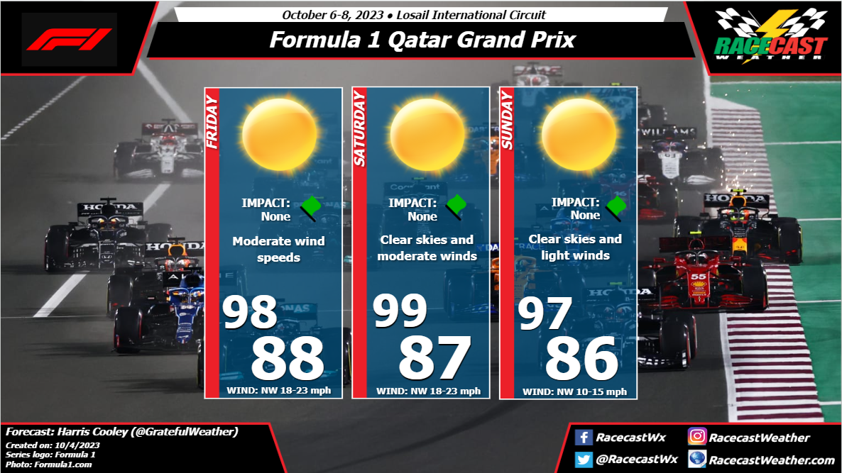
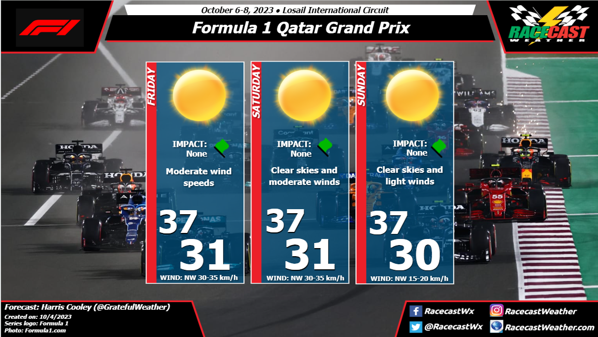
Today's practice sessions at IMS have been affected by rain, associated with an upper level trough and an approaching cold front. This front will move through the area this evening. Behind this front on Friday, nice weather is expected, with mostly sunny skies and breezy conditions through the day. Highs will peak in the upper 60s. On Friday night, another cold front will pass through the area. It may bring some showers to the Speedway, but I expect that it will arrive after 8 pm, after the qualifying session ends at 7 pm. It is possible that some showers could arrive earlier than that, but I think the chance of rain affecting the qualifying is low. Behind the second cold front, temperatures will get much colder. Lows on Saturday morning will be in the lower 40s, with daytime highs only in the upper 50s with sunny skies. The northwest wind will continue to bring cool temperatures through Sunday, with lows in the 30s and highs in the 50s. Clouds will increase on Sunday as a weak upper level disturbance crosses the area. By: Harris Cooley The site will be situated along the NW boundary of a building Low pressure system. This will keep winds northwesterly and moderate to strong as winds will be sweeping through the Persian Gulf. Skies will be clear but the temps will be high once the sun is out. The wind and sand on the track will add to the grip issues that the high track temps will bring during the practice sessions.
Race night will be calm and clear with manageable track temps as the asphalt will be 'cooling' throughout the race with the sun down. Winds will be calm so there should not be any major implications with sand blowing around. A metric graphic is pasted below... |
Social Feeds
Authors
Doug Schneider Partners
Categories
All
Archives
December 2023
|

