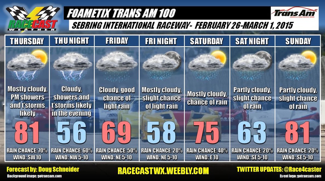
Racecast Weather - Your Source for Race Weather Information
  • Home
  • Racecasts
  • 2023 Schedule
  • Services
  • Contact
  • Bios
  • Links

Friday forecast update: Foametix Trans Am 100

2/27/2015

Comments

 
By Doug Schneider
Picture
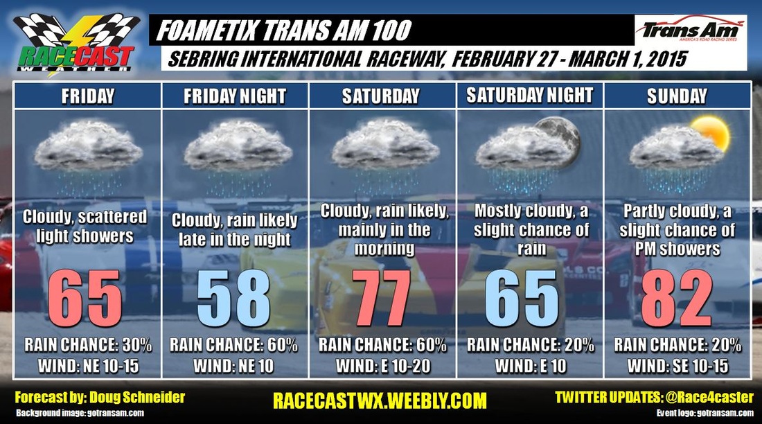
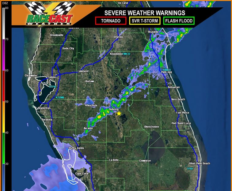
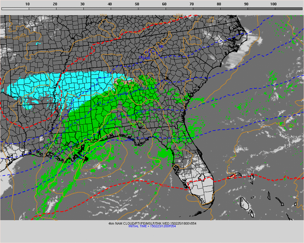
It looks like a couple of wet days are in store at Sebring for the Trans Am and SVRA event today and tomorrow. Scattered showers are expected to move through the Sebring today, with most of the activity coming in the afternoon. It may affect the Trans Am qualifying session at 3:30 PM. Rainfall amounts today will likely be around a tenth of an inch.

Later tonight, a low pressure system will develop off the east coast of Florida, and track toward the west. This will bring more moisture and lift toward Sebring, beginning late tonight and continuing into Saturday. Rain is likely to occur at any time during this period, but I think most of it will come Saturday morning. Rainfall amounts will probably be between a tenth to a quarter inch. The track will be wet for the late morning Trans Am practice session and second chance qualifying. It will also be breezy as the low approaches the area, with winds 10 to 20 mph. Most of the rain will end by sunset Saturday.

Sunday continues to look like the best day of the event. There could still be an isolated shower in the area, but the odds look good that the track will stay dry all day. Temperatures will warm to around 80, with a southeast wind at 10 to 15 mph.

You can keep an eye on the radar by clicking the Live Radar tab at the top of our website.
Comments

Thursday update: Foametix 100 Trans Am at Sebring

2/26/2015

Comments

 
By Doug Schneider

A line of showers will move through Sebring this morning. These showers are along a cold front, and once the front moves through, the threat of rain should end. The afternoon Trans Am test sessions should be dry. 
Picture
The forecast for the rest of the event looks much the same as before, with a chance of showers Friday and Saturday as the front lifts back to the north of the track. Highs both days will be between 70 and 75. Sunday continues to look warmer, with highs reaching to near 80, with just a slight chance of an afternoon shower.
Comments

Cooper Tire Winterfest at Barber Motorsports Park: Wednesday Morning Update

2/25/2015

Comments

 
By Scott Martin.

Good morning. I hope you are having a great day today. First of all I want to start off by apologizing by not getting an update out earlier this morning. I forgot about a test that was due today for one of my classes and I had to complete it by 11AM. To tell you the truth, the update is pretty much going to be mostly a repeat of the last one from Tuesday night.
Picture
A Winter Storm Warning is in effect for north-central Alabama until midnight. Some of the counties on the southern end of the warning were changed to a Winter Weather Advisory. The track is still under the Winter Storm Warning. Governor Robert Bentley has also declared a State of Emergency for today until the need for it passes (probably 8AM tomorrow).
Picture
This latest radar image taken from SimuAWIPS shows that snow is out there. The rain is falling now will work to cool the layers of the atmosphere and snow will start to fall within an hour or two. Still believe that there is a potential for 2-4 inches. Snowfall should start to fall somewhere around 1PM and fall steadily (sometime heavy) until about 7 or 8PM tonight. Once again, if the storm tracks just 20 miles to the north from the projected path, you may just receive rain. If it tracks the same to the south, you may receive up to 5-6 inches of snow. It is that tight of a forecast. Some will be happy, and some will be highly disappointed (according to what you want).

The good news is that tomorrow is looking to be a lot better day. Partly cloudy skies with temperatures topping out in the mid 40s with no rain or snow chance.
Comments

Cooper Tire Winterfest at Barber: Tuesday Night Update

2/24/2015

Comments

 
By Scott Martin.
Here the latest update for the Wednesday forecast for the Cooper Tire Winterfest at Barber Motorsports Park.
Picture
A Winter Storm Warning goes into effect for north-central Alabama starting at 9AM Wednesday morning, and lasts until midnight. Governor Robert Bentley has already declared a State of Emergency for the whole state starting at 6AM. All of the school systems in and around the area are closed tomorrow.

Much of north-central Alabama will receive a decent amount of snow, as much as 8 inches possible in some isolated spots. There is an issue with this forecast. Latest models have been trending a little more north with a sharp drop-off in snow coverage on the southern edge of this system. Right now, the Irondale to Leeds area (where Barber is located) is in a 2-3 inch bullseye as of now. That zone is so thin right now that if the system moves just a few miles north, it could be just a cold rain. If it moves just a few miles south, it could be a snowfall as much as 4-6 inches. 


Bottom line:
It will start off as rain during the morning, then changing over to snow sometime before 11AM. Snow will be heaviest from the time period of 1PM to 7PM. If the system moves a little south of the forecast track, it is possible to have a small chance of convective snow called “thundersnow.” Highs will only reach the mid 30s and start to fall to around 30 as the snow falls. Once again it is difficult to say what the forecasted accumulations will be. I’ll throw my guesstimate out there and say 2-3 inches for the area. Snow should taper off by 10PM.

During the heavy periods of snowfall, travel could become difficult in the area, and might become impossible for a few hours. With the state of emergency ordered, all of the state agencies will take the necessary actions to be prepared to respond to deteriorating conditions all across the area.

I’ll be back with another post in the morning for any updates to the snow and how the rest of the week will turn out. Have a great night. Tomorrow will be a busy day.

Comments

Tuesday forecast update: Foametix Trans Am 100

2/24/2015

Comments

 
By Doug Schneider
Picture
The forecast trends are moving toward wetter conditions at Sebring later this week. I am becoming more confident that there will be showers and perhaps a few thunderstorms around for the test sessions on Thursday afternoon and into the evening. I'm less certain about how much rain there may be, as it will depend on whether one of the stronger storms passes over the track. Up to half of an inch of rain will be possible Thursday afternoon and evening. There may be a little sunshine Thursday morning, which may allow temperatures to warm into the 80s.

A cold front pushes through on Thursday night, and stalls across south Florida. I've lowered temperatures on Friday as a northeast wind brings in cooler air behind the front, and plenty of clouds are expected to linger all day. Moist air aloft may continue to run up and over the front, which could produce some light rain Friday through Saturday. I expect that if there is rain these days, it will only be a few hundredths of an inch. 

My forecast confidence lowers for the weekend. The front that stalled to the south is expected to lift back to the north on Saturday, with high pressure to the east bringing warmer temperatures for Sunday. How quickly this occurs will affect the timing of rain and temperatures on Saturday. I have raised the chance of rain Saturday because it looks like the front is slower to lift northward than previously indicated by the models. Sunday looks like the best day, with temperatures reaching into the lower 80s, and just a slight chance of rain showers as the front is expected to be well north of the area by then..
Comments

Cooper Tire Winterfest at Barber Forecast: Tuesday Morning Update

2/24/2015

Comments

 
By Scott Martin.
Picture
Not much has changed in the forecast, just a little tweaking. Still, snow is the word for Wednesday. Here is the latest forecast update for Barber Motorsports Park round of The Cooper Tire Winterfest.

Today:
After another morning having to deal with sleet and freezing rain, and with more travel issues on the roadways, conditions will improve and we should not expect any more issues after 10AM. Skies will be mostly cloudy today with winds shifting out of the west at 0-5 MPH. Highs should top out in the mid 40s. Precipitation is not expected after 10AM. Tonight will be mostly cloudy as well with a low in the lower 30s. No travel issues tonight and precipitation is not expected.

Wednesday:
I hate to say it, but it looks like “Old Man Winter” might win out on this day. Models have come into good agreement that a system will be moving through that will bring snow to the area. As of right now, the timing on the action to start is from 6AM to 9AM. It may start off as rain and then quickly change over to snow during the morning, and remain snowing throughout the day and evening hours. Highs are expected to reach the low to mid 30s, but temperatures will drop as soon as the snow starts to fall due to evaporative cooling.

As of right now, a Winter Storm Watch is in effect for the area, but I expect that to be upgraded to a Warning sometime during the day today. As of now, I’m expecting accumulation amounts to average 2 to 4 inches. With this type of Gulf of Mexico low pressure system in Winter, there will be a deformation axis to develop that will lead to a narrow strip (about 25 miles wide) of heavier snowfall that could be up to 8 to 9 inches. It will be difficult to know where that will set up until the system has arrived. This forecast will probably change before the system arrives. As of now, one model is saying 10 inches for the area, whereas another is only saying 1/2 inch. One thing is for sure, there will be major travel issues somewhere if not all over central Alabama.

Thursday:
This will be the best day of the week so far. Partly cloudy skies and warmer. Highs will top out in the mid 40s. Winds will be out of the north around 5 MPH. Finally, no rain or snow expected.

I will update the forecast as soon as more information comes available and if there are any changes to the models. Hope you have a great day today.

Comments

Monday Evening Update for The Cooper Tire Winterfest at Barber Motorsports Park

2/23/2015

Comments

 
By Scott Martin.
Picture
This forecast is continuing to change overtime that I look at model data for this week. Here is what I have for the latest update...

Tuesday:
I'm sticking to what I said in the last update from this morning. One of the latest model runs may have some snow flurries or light snow showers falling before 9AM instead of freezing rain. After that, just expect mostly cloudy skies with highs topping out in the mid 40s (above freezing by 10AM). Chance of snow or sleet before 9AM is 20%. Winds from the W at 0-5 MPH.

Wednesday:
The latest model runs are still showing a significant snow event for the Birmingham area. As of now, the potential is there for 1 to 3 inches, with some isolated amounts up to 8 inches where a deformation zone develops in the system. Time of arrival should be sometime between 7AM to 11AM. It is still early for this forecast, as I said earlier, snow events in the Deep South are very challenging for the most experienced meteorologists. Right now the high should top out in the mid 30s, but I believe once the snow starts falling, temperatures will fall to the lower 30s to even the upper 20s by 5pm. More snow is expected during the evening. Another inch of accumulation is expected before the snow ends around midnight.

Thursday:
Partly cloudy skies and a break from the all the sleet and snow. Highs will top out in the mid 40s with winds from the N at 5-10 MPH.

Once again, it only takes a shift of a few miles to make this an all rain even or a larger snow event. I'll update the blog and send out more info on my Twitter feed and our Facebook page.
Comments

Update for Cooper Tire Winterfest at Barber

2/23/2015

Comments

 
By Scott Martin.
Picture
Can you hear Anna from Frozen singing, "Do You Want To Build A Snowman?" For people in central Alabama, we are ready for the Spring to get here. If only the weather timeline was a week faster, we would experience temperatures in the mid to upper 60s with partly cloudy skies. Unfortunately, "Old Man Winter" still has one more trick up his sleeve before he departs Alabama for now. So here is the update that I have for you at this moment.

Tuesday:
The day will start off mostly cloudy with a slight chance of either sleet or freezing rain before the 8 o'clock hour. There may be some slick spots on the roads and bridges, but I do not believe that major travel problems will happen for this time. If conditions change, I will update on Twitter (@RaceWx4You) as soon as possible. After that, the day will stay mostly cloudy. You may see the sun peek through on some occasions, but not for long. Highs will reach the mid 40s by the mid afternoon. Winds will be light out of the N at first, but will be shifting out of the SW during the afternoon.

Wednesday:
Here is the day with the big questions... Will it snow?... and... How much will we get?
Picture
This is the image from the latest run of the NAM 4km model valid at Wednesday at 12pm. Snowfall will have started falling in the Birmingham area at that time. It should take a while for the temperature to cool down enough for accumulations to happen unless the snowfall starts off heavy. If that happens, accumulations could amount quickly for this area. Now I am not calling for blizzard conditions, but there could be well more than enough to build some decent snowmen.
Picture
This image of the meteogram for Birmingham may look confusing to you, but I'll explain. Lines on this graph represent model output for snow accumulation amounts for the Birmingham area. You see that one model is predicting about 5.75 inches while another is only predicting 0.5 inches. Right now it is too early to put an estimate on exactly how much snowfall we will receive. Sometimes you will not know until the event is finished and you go out and measure what you have in front of you to know.

This could possibly turn out to be a high-impact weather event for the Birmingham area. I will have a better understanding this evening and Tuesday morning about what will happen. If I were to make a guess on this right now, I would say 3 to 5 inches of snow, but that is only a guesstimate right now... not a forecast.

Bottom line: Wednesday will be partly to mostly cloudy during the AM, with a decent chance of rain (at first) changing over to snow by lunch time, and snowing through the rest of the afternoon and evening hours. Highs will top out in the mid 30s by noon. Once the snow starts to fall, evaporative cooling will start and the temperature will probably drop to the low 30s to even the upper 20s by nightfall. If there is decent snow coverage on the ground, I'll have to adjust temperatures for Thursday.

Thursday:
By the time you wake up on Thursday morning, the snow will be gone and you may see the sun break through the clouds at times. I'm calling for partly cloudy skies and highs reaching the mid 40s (may be a little lower if there is decent snow coverage on the ground). Finally there is no rain or snow chance and hopefully all track activities will go on uninterrupted.

I wish this could be a better forecast. Snow events in the "Deep South" are just so hard to forecast, even for the professionals who have been at this for many years. If this event travels 25 miles farther North, we may just get rain and snow flurries. If it travels 25 miles further to the South, we may get 8 to 10 inches of snow. I'll have updates to this developing snow situation as more information comes in and models come into better agreement.
Comments
<<Previous

    Social Feeds


    Instagram


    Authors

    Doug Schneider
    Scott Martin
    Stephen McCoy

    Harris Cooley 


    Partners

    Picture
    Picture
    Picture
    Picture
    Picture

    Categories

    All
    F1
    IGTC
    IMSA
    Indycar
    Le Mans
    MRTI
    NASA
    Outlooks
    Photos
    PWC
    Racecasts
    SCCA
    SRO
    Trans Am
    TUSC
    Verification
    Weather Education
    WEC


    Archives

    March 2023
    February 2023
    January 2023
    December 2022
    November 2022
    October 2022
    September 2022
    August 2022
    July 2022
    June 2022
    May 2022
    April 2022
    March 2022
    February 2022
    January 2022
    December 2021
    November 2021
    October 2021
    September 2021
    August 2021
    July 2021
    June 2021
    May 2021
    April 2021
    March 2021
    January 2021
    December 2020
    November 2020
    October 2020
    September 2020
    August 2020
    July 2020
    June 2020
    March 2020
    January 2020
    December 2019
    November 2019
    October 2019
    September 2019
    August 2019
    July 2019
    June 2019
    May 2019
    April 2019
    March 2019
    February 2019
    January 2019
    December 2018
    November 2018
    October 2018
    September 2018
    August 2018
    July 2018
    June 2018
    May 2018
    April 2018
    March 2018
    February 2018
    January 2018
    December 2017
    November 2017
    October 2017
    September 2017
    August 2017
    July 2017
    June 2017
    May 2017
    April 2017
    March 2017
    February 2017
    January 2017
    December 2016
    November 2016
    October 2016
    September 2016
    August 2016
    July 2016
    June 2016
    May 2016
    April 2016
    March 2016
    February 2016
    January 2016
    December 2015
    November 2015
    October 2015
    September 2015
    August 2015
    July 2015
    June 2015
    May 2015
    April 2015
    March 2015
    February 2015
    January 2015
    December 2014
    November 2014
    October 2014
    September 2014


Powered by Create your own unique website with customizable templates.