|
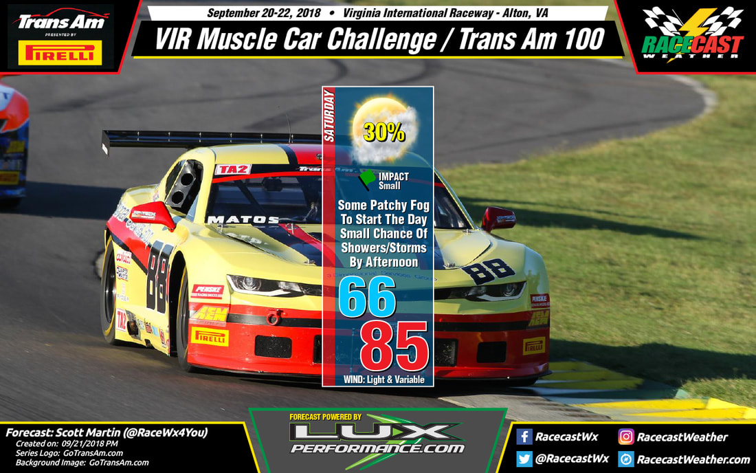
By Scott Martin (@RaceWx4You) The forecast is still on track for Saturday at VIR as the dome of high pressure has been forced eastward out to see and a cold front with an associated center of low pressure makes its way towards the area. We may have some patchy fog to start off the morning, but that should quickly lift by 8:00 am or so. After that, skies will be mostly clear, but you will notice that the clouds will build in coverage throughout the day. A stray shower may be possible during the late morning hours, but I believe any rain chances will hold off until the early afternoon hours. At this point, I'm going with a 30% chance of a few scattered showers and storms during the afternoon, with the higher chances of heavier storms move in just before sunset. Afternoon highs will top out in the mid-80s and winds will be light and variable through the day. Winds are expected to pick up a little right at the beginning of the evening hours as the cold front gets closer to the area.
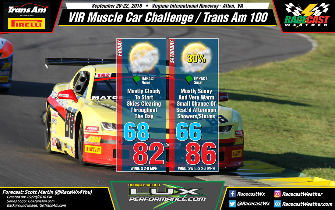
By Scott Martin (@RaceWx4You) A big dome of high pressure will be sitting over the area on Friday, allowing the sinking air to squash any chance for any thunderstorm development throughout the day. Skies will start off mostly cloudy, with the possibility of some patchy fog during the early morning hours. The good news is that the fog will be gone by the time the cars take to the track later in the morning. Clouds will dissipate somewhat throughout the day, ending up mostly clear by sunset. Afternoon highs will top out in the lower 80s (and I may have actually been too conservative with the high as the mid-80s are not out of the realm of possibility).
Unfortunately, the high pressure gets quickly pushed off of the coast and is replaced by a center of low pressure and an associated cold front. Skies will be mostly sunny for much of the day and temperatures will be warmer as warm air will be advected into the area from the south. By the time the afternoon arrives, there will be enough lift from the approaching front and instability from the daytime heating to fire off a few scattered showers and storms. Chances will be around 30% while cars are on the track, but those will increase after sunset as the front arrives in the area. Afternoon highs will be in the mid-80s and there will be very little wind to help cool you off. Be sure to stay hydrated, wear your hats and shades, and don't forget to sunscreen up. By: Stephen McCoy - @stephenmmcc There are a few changes in this update to the forecast for the next two days at Sonoma Raceway. Some higher wind speeds are looking likely in the afternoon for both Saturday and Sunday as a result of a stronger pressure gradient at the surface. The slightly cooler temperatures seen for Saturday's high and Sunday's low are likely caused by these stronger winds as the cooler air moves into the region from the Pacific.
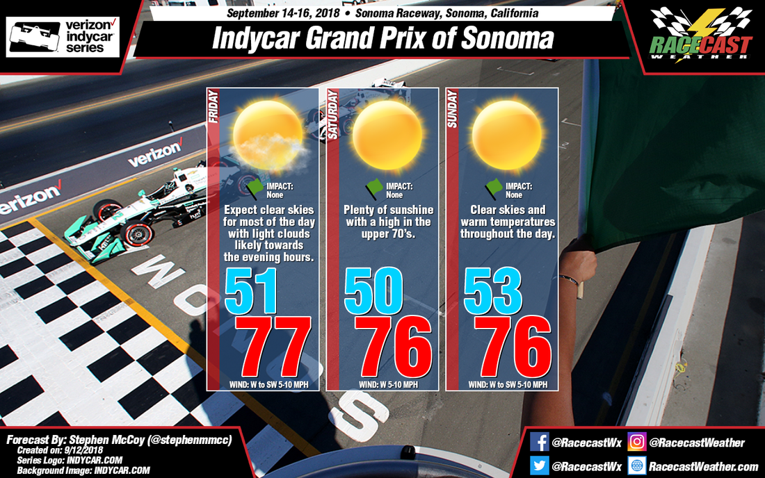
By: Stephen McCoy - @stephenmmcc Clear conditions with warm temperatures continue to dominate the forecast for the Indycar Grand Prix of Sonoma at Sonoma Raceway. High temperatures for the weekend are expected to stabilize around the mid-to-upper 70's and with dew point temperatures in the upper 40's to low 50's, heat index values should remain close to the actual temperature. Some moisture in the upper levels could bring some light cloud cover to the region in the late afternoon to evening on Friday, but otherwise conditions will remain clear. Expect maximum wind speed of 5-10mph from the west to southwest each day.
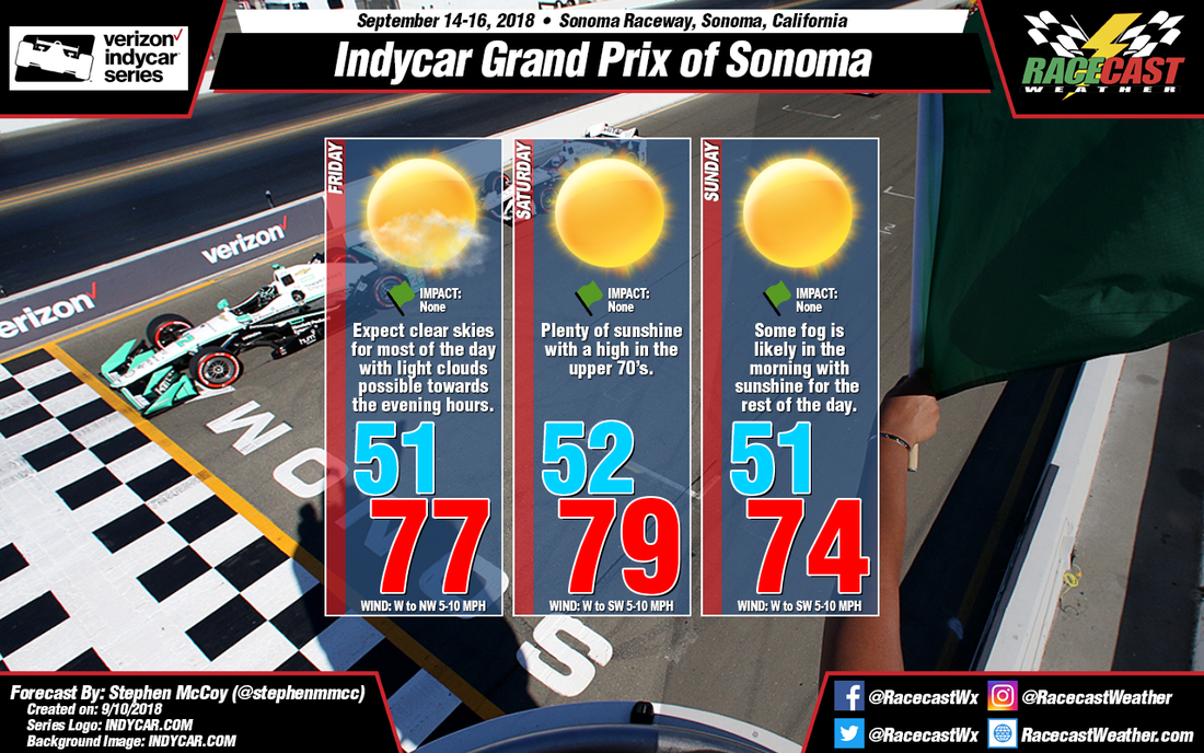
By: Stephen McCoy - @stephenmmcc A picture-perfect weekend is in store for Indycar for the season finale this weekend at Sonoma Raceway. The eastern edge of an upper level trough will be over the region through early next week with winds primarily from the southwest during this period. The winds will bring mostly dry air to the region during the weekend aside from the later hours on Friday, where some more moisture will cause light cloud cover into the evening and nighttime hours. Surface winds will be around 5-10 mph each day, generally from the west, but they could fluctuate between the northwest and southwest. With plenty of sunshine, temperatures will reach the mid to upper 70's each day, with dew point temperatures in the upper 40's to low 50's, keeping the heat index close to the air temperature.
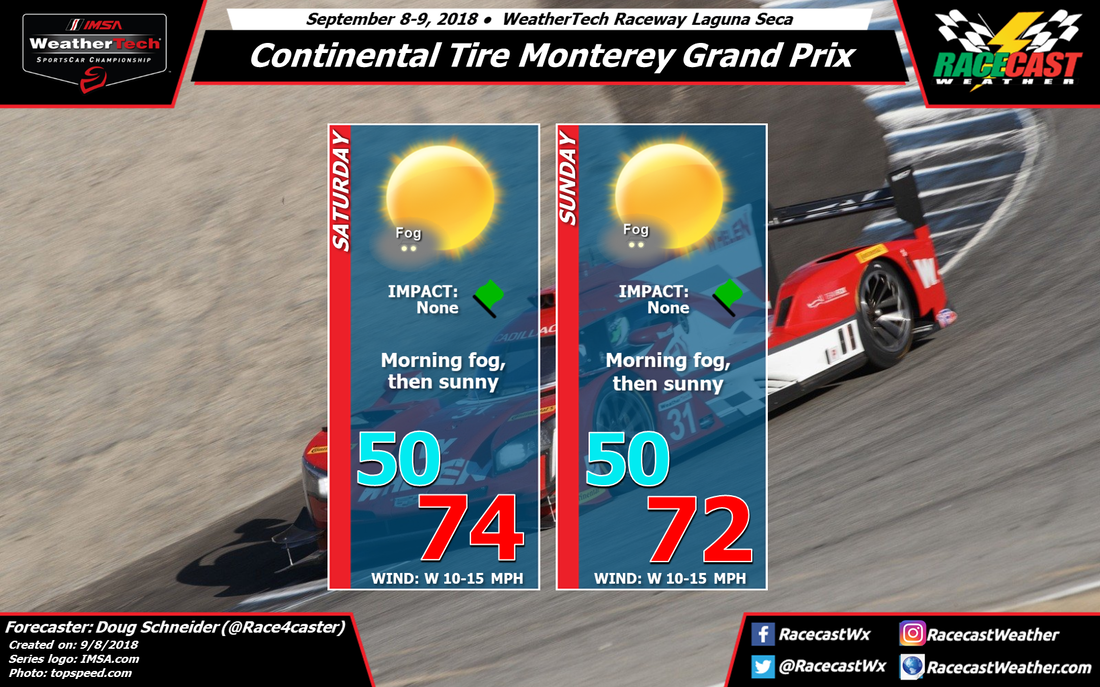
On Sunday, some fog looks to be possible as saturated air at the surface will be present under a temperature inversion and dry air aloft, but it will erode into the late morning with clear conditions returning for the race. By Doug Schneider The forecast remains steady for the Monterey Grand Prix at Laguna Seca this weekend, with nice weather still expected. The only potential issue may be fog each morning, which is fairly standard for the Monterey peninsula this time of year. The fog will burn off between 8 and 10 am, with sunny skies expected for the rest of the day. High temperatures in the low to mid 70s and low humidity will make for very pleasant conditions to take in some great racing action.
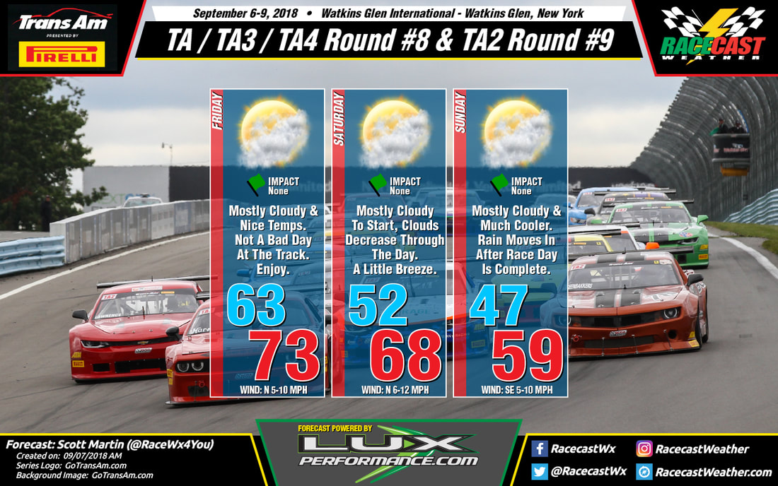
By Scott Martin. Latest forecast update powered by LuxPerformance.com for the Trans Am Series at Watkins Glen shows much better conditions throughout the event weekend. May be a race against rain on SUN, but should hold off until after the TA2 race. The good news is that the effects from the remnants of Tropical Storm Gordon will not be a factor at all in the forecast. Have a great race weekend!
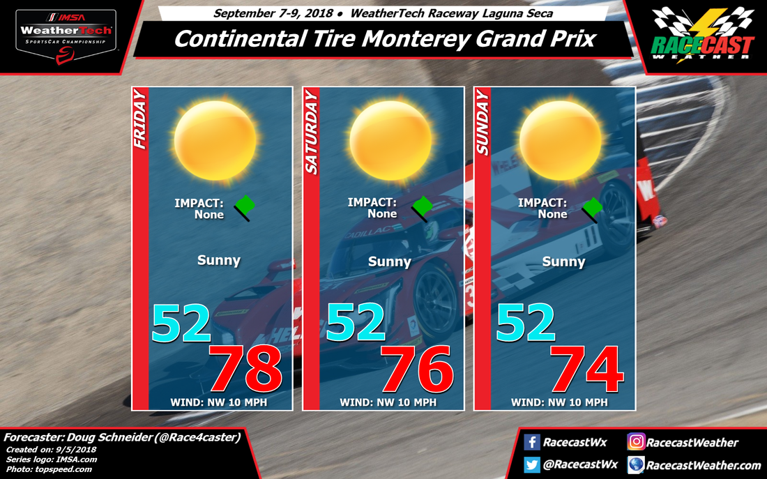
By Doug Schneider The weather at Laguna Seca for IMSA weekend continues to look spectacular, with lots of sunshine and pleasant temperatures in the mid to upper 70s each day. There hasn't been much change to the forecast since Monday, as models agree that a large high pressure system will remain off the west coast through the weekend.
|
Social Feeds
Authors
Doug Schneider Partners
Categories
All
Archives
December 2023
|

