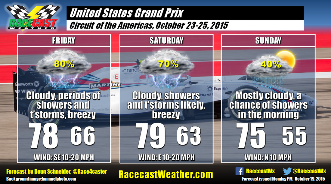
Racecast Weather - Your Source for Race Weather Information
  • Home
  • Racecasts
  • 2023 Schedule
  • Services
  • Contact
  • Bios
  • Links

Thursday forecast update: United States Grand Prix

10/22/2015

Comments

 
By Doug Schneider
Picture
Confidence is increasing that there will be a lot of rainfall across central Texas over the USGP weekend. There is an upper level trough crossing New Mexico today, with a cold front ahead of it generating thunderstorms across northern Texas. As the trough and the front continue to move slowly southeast, abundant tropical moisture will be drawn into central Texas on Friday and Saturday.

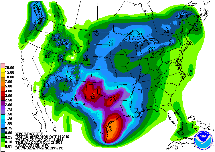
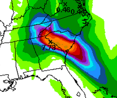
​On Friday, the majority of heavy rain and thunderstorms will be to the north of Austin, but it is still likely that some storms will hit the track Friday afternoon. There is a marginal threat of severe storms on Friday afternoon and evening, with large hail being the main threat, and strong wind gusts possible as well. With the front continuing to approach, the Circuit of the Americas will see a steady train of showers and thunderstorms on Saturday, many of which will produce heavy rain and flooding. Here is the latest map of forecast rainfall from the National Weather Service's Weather Prediction Center for Thursday afternoon through Sunday afternoon:
Picture
COTA is located approximately at the white dot, which is in the range of 5 to 7 inches of rainfall, the majority of which will fall on Saturday. With this much rainfall, and a threat of thunderstorms, I think it is likely that all of the on track activity on Saturday at COTA will be canceled.

A Flash Flood Watch has been issued by the NWS for the Austin area from Friday morning through Sunday morning. Heavy rain will lead to flash flooding of roads, low lying areas, and creeks. If you're driving around Austin on Friday and especially Saturday, be careful. Never drive across a road that is flooded, and stay alert to any flash flood warnings that may be issued.

The big question is when will the rain end? There is still some disagreement among the models regarding the timing of this, but the majority seems to favor decreasing rain chances through Sunday morning as the trough and front move east of the area and drier air moves in behind them. The race is scheduled to start at 2 pm local time. It appears likely that the rain will end by this time, although I can't entirely rule out some showers affecting the race. I'd put the chance of a dry race around 70%. 

Unfortunately, or usual live radar link will not be working this weekend. Here's a link to the NWS radar site, which includes any warnings that are issued. 
Comments

Forecast for the United States Grand Prix

10/19/2015

Comments

 
By Doug Schneider
Picture
While we don't normally forecast for F1 races here at Racecast Weather, I'm making an exception this time, because 'Murica. 

The pattern across the country toward the later half of this week will be a large high pressure ridge over the eastern states, and a low pressure trough over the western states. With Texas located between these two features, there will be a deep southerly flow of moisture into the area. There is a good potential for a lot of rainfall on Thursday, Friday, and Saturday across Texas. Here's the total rainfall forecast from the National Weather Service through next Monday:
Picture
Circuit of the Americas is in the dark purple to dark red area, which translates to between 2 and 3 inches of rain. Keep in mind that this is a forecast of rainfall over an entire week, so it doesn't mean that is how much will fall during the event. As the timing stands right now, it does look like the bulk of this rainfall will come Thursday night through Saturday night. My confidence in this forecast is fairly high right now, as the models appear to be in good agreement with this wet pattern, which is why I went with high rain chances on Friday and Saturday. Some thunderstorms will be possible at times, and it will be breezy both days, with winds from the southeast to east at 10 to 20 mph. A threat of severe weather appears unlikely at this time. It is likely that some, if not all, F1 practice and qualifying sessions will be wet.

The timing of the end of the rain is a little less certain at this point, with some models being a little faster than others to end the rain. It could linger into Sunday morning, so I have a 40% chance of rain at that time. If this timing holds, it is likely that the race will be dry on Sunday afternoon. I'd put the chances of a dry race at about 75% right now. 

If there are significant changes in this forecast through the week, I'll make a new post with an updated forecast. Be sure to follow our Twitter and Facebook feeds for the latest information, or subscribe to our RSS feed.
Comments

El Niño: Meteorological menace?

10/14/2015

Comments

 
By Doug Schneider

Perhaps you've seen some headlines like this one lately:
Picture
If you haven't, you probably will soon. Irresponsible headline writers will try to grab your attention and strike fear into everyone with dire warnings of the terrors of the El Niño that's GOING TO HIT YOU.
Picture
Me when reading this headline.
Despite the headlines, El Niño is not a terrible storm that is coming to your neighborhood to wreak havoc. There is going to be a strong El Niño this winter. But what exactly does that mean, and how does it affect you?  

El Niño is a phase of what is called the El Niño-Southern Oscillation (ENSO) cycle. The ENSO cycle describes the fluctuations in temperatures between the ocean and atmosphere in the east-central Pacific near the equator. The other part of the ENSO phase is called La Niña.

The fluctuations in temperature are due to the strength of the trade winds in the equatorial Pacific. The trade winds usually move from east to west, which pushes the warm sea surface water to the west. As the water moves away from the South American coast, deep, cooler water rises to the surface to replace the displaced warm water. 
Picture
During the transition to ​El Niño, the trade winds begin to weaken. This pushes less warm water westward across the Pacific, so the warm water tends to remain in the central and eastern Pacific. Eventually, the trade winds can reverse their normal westerly direction and begin to blow toward the east. 
Picture
So ​El Niño is simply when water temperatures in the east equatorial Pacific Ocean are warmer than normal. La Niña is when the water temperatures in the east equatorial Pacific Ocean are colder than normal. 

The name El Niño is Spanish for "the boy", but refers to the Christ child because its effects near the South American coast are often most noticeable around Christmas. The water near the coast during El Niño tends to be nutrient-poor, which can have an impact to local fishing.

The image below shows what El Niño looks like using a satellite that detects sea surface temperatures. It shows the departure of the water temperature from normal, and you can see the abnormally warm water (orange and red areas) along the equator and near the northwest coast of South America. 
Picture
Picture
So how does El Niño impact the weather in North America?

As the position of the warm water along the equator shifts across the Pacific Ocean, the position where the greatest evaporation of water into the atmosphere also shifts with it. This has a profound effect on the typical position of the jet stream across the Pacific Ocean.

​The jet stream is a band of strong winds in the upper levels of the atmosphere that impacts the formation of weather systems. El Niño tends to extend the jet stream farther east and position it farther south than normal. This results in a shift of the typical storm track from the northern to the southern part of the U.S. It also tends to result in more low pressure systems forming west of California. 

The change in the typical tracks of storms can cause increased precipitation across California and the southern U.S. Northern states tend to have warmer and drier winters during an El Niño event, due to the polar jet stream shifting farther north, which brings less cold air southward. These effects tend to be strongest across North America during the winter.

Picture
The ​El Niño of 1997-98 was a particularly strong one, and that winter saw record rainfalls and destructive mudslides in California. While every event is different, the forecast is for a similarly strong El Niño to occur this winter. 

But there are other effects in the atmosphere that will influence the weather across the U.S. this winter, and this makes it difficult to say that this winter's weather will be similar to 1997-98. We can only make general statements about what could happen, such as the chance of above normal rainfall in Southern California is higher, or that the northern parts of the U.S. is more likely to have above normal temperatures. El Niño can tilt the odds of a certain type of weather one way or the other, but there is not a clear connection between El Niño strength and weather impacts. 
​
​So dire warnings of a monster, deadly, destructive El Niño are extremely misplaced. The best approach is to keep watching the weather forecasts and take any warnings from the National Weather Service seriously. There's no need to panic about this guy:
Comments

Racecast Verification: Trans Am at NOLA

10/13/2015

Comments

 
By Scott Martin
Picture
It has been a while since I have done a forecast verification for an event. Being a full-time college student while being a stay-at-home dad teaching homeschool to three children takes a lot of time away, but I really do enjoy it. I was able to squeeze in a little extra time today to do a verification for the Trans Am series at NOLA Motorsports Park from this past weekend, and here are the results.

As you can see, I was pretty close to being dead-on for most of the forecast. Where I struggled is underestimating the cold air that came with a cold front on late Friday evening. A north wind helped to keep high temperatures lower on Saturday as I forecasted temps to be warmer. It was not a big miss (less than 5 degrees), but did have one forecasted high 6 degrees too warm. I also didn't expect temperatures to warm as much for Friday before the cold front moved through, but was only off by 4 degrees and less. Now there was no doubt that precipitation would stay out of NOLA, and I forecasted a 0% chance throughout the time frame. I did think that there would have been a slight chance of rain with the front passage early on Saturday morning on my first forecast, but changed that to none due to the fact that models were trending dry and moisture was staying well to the north.

Most meteorologists would claim this as a very successful forecast, and as a meteorology student, I consider it one as well. I still see that I need to work in some areas. A perfect forecast is nearly impossible, but my goal is to have as many of those slots to be in the green.

Our next forecast will be for the Trans Am series action at COTA in November (6-8), and then at Daytona (12-14). After that, our last forecast will be for the 25 Hours of Thunderhill in December.
Comments

Racecast verification: Petit Le Mans

10/4/2015

Comments

 
By Doug Schneider
Picture
The forecast for Petit Le Mans was extremely difficult due to several different factors in the weather pattern that developed through the week and poor model consistency. But I won't make that an excuse. This was not a good forecast for me, and I sincerely apologize.

When I began to look at the data over a week before the race, the models were pointing toward a weak trough off the east coast and a large ridge over the central states that would push a front through on Wednesday followed by a dry northwest flow aloft across Georgia Thursday through Saturday. Sunday afternoon, some, but not all, of the models started to change their tune, showing a deeper and slower upper trough. At this point, none of them hinted at the existence of Hurricane Joaquin. Gradually the models came into better agreement on a deep trough over the southeast, with Joaquin being positioned east of the Bahamas. By the Wednesday forecast update, I started to push the chance of rain into Friday, but it was not enough as the models continued to show a slower and slower system that would pick up tropical moisture from Joaquin. There was still quite a bit of disagreement among the models on where the moisture axis would be located. I was too slow to jump on the bandwagon, as I was waiting for better model agreement on where the rainfall would be. It wasn't until Thursday's forecast update that I brought in a chance of rain on race day. In hindsight, this was probably a day too late. At least I saved face a little with good forecasts on Thursday and Friday. Better late than never, I suppose.

Here's my forecast week, in GIF form.

Saturday: Feeling good, it's going to be a nice and easy forecast to end the season. 
Picture
Sunday: GFS model starts to hint a strong low pressure system developing in the southeast, while other models disagree. 
Picture
Monday: Now other models are starting to agree with the GFS, but I remain skeptical. We'll see.
Picture
Wednesday: Hurricane Joaquin might come into play. Uh oh.
Picture
Thursday: Welp. I messed up.
Picture
Petit Le Mans was pretty much like -
Picture
Comments

Race day weather: Petit Le Mans

10/3/2015

Comments

 
By Doug Schneider
Picture
 Believe it or not, there is silver lining in this very wet forecast. Yesterday I mentioned that rainfall amounts were expected to be in the 1 to 3 inch range during the race. It appears likely that amounts will be on the lower end of that range, around 1 inch to at most 2 inches, and 3 inches appears unlikely (but still possible).

Here's the situation this morning. There is a band of heavy rainfall oriented north to south across South Carolina, while the rain over Georgia is more sporadic and showery. 
Picture
That band of rain is expected to rotate to the west, and be aligned with the yellow line by around 8 pm tonight (Road Atlanta is the red dot). So most of the day will be like this morning, with on/off sporadic showers with a few heavier downpours now and then. There may even be some periods when the rain stops. But as we get into the afternoon, the rain should become more frequent and heavier. The worst conditions during the race will likely be at night. 

A Flash Flood Watch is in effect for the area. Avoid low lying areas and nearby creeks, especially Cooper Creek on the east side of the track (from behind the secondary paddock to turn 6). If you're at the track and leaving Sunday morning, you may encounter flooded roads. Do not attempt to cross are road when water is flowing across it! It doesn't take much water to wash a car off the road and carry it downstream. 

To clarify again, this rain is not directly associated with Hurricarn Joaquin, but Joaquin is helping to supply abundant tropical moisture into the southeast. Joaquin is still east of the Bahamas, and is expected to stay out to sea as it curves north. Here's a satellite image that shows the connection between Joaquin and the low pressure system over the southeast.
Picture
I'll be live tweeting weather conditions at the race all day - @Race4caster. If you have a question about the weather, I'd be happy to answer on Twitter. Our live radar link is available at the top of the website.
Comments

Friday forecast update: Petit Le Mans

10/2/2015

Comments

 
By Doug Schneider
Picture
The forecast is coming into better focus, and there's one thing I'm sure about:
Picture
The uncertainty is how much it will rain. Here's a graphic of forecast rainfall from the NWS for Saturday:
Picture
Road Atlanta is near the top of the first 7, where the colors change from blue to purple to red. This gives you an idea of how tight the gradient of rainfall is in the area near the track. Just a slight shift of the heavy rain to the east, and Road Atlanta could get only an inch. A slight shift to the west, and it will get 7 inches. As depicted in this graphic, Road Atlanta is looking at 1-3 inches of rain on Saturday. But there is a lot of uncertainty in that forecast amount. 

Let me emphasize that this rain is NOT directly associated with Hurricane Joaquin. There is a low pressure system that is sitting over the southeast states, pulling abundant tropical moisture into the region. As the forecast stands now, Joaquin is expected to stay out in the ocean and not make landfall. 

Today, showers will be on and off throughout the day. The track will stay wet all day, but the rain will be sporadic. By Saturday morning, the rain should be more constant, and it will likely be heavy at times. This will continue through the end of the race Saturday evening. 

If you're camping at the track, I highly recommend that you set up your tent on higher ground. Avoid low lying areas, as they are likely to become flooded. You will especially want to avoid being near Cooper Creek, which runs parallel to the east side of the track, from behind the secondary paddock area past the esses to turn 6. It is possible that the creek will flood. 

Despite the rain, I'm sure everyone at the track will have a good time. Remember, a wet day at the race track is better than a dry day anywhere else.
Picture
Comments

Thursday forecast update: Petit Le Mans

10/1/2015

Comments

 
By Doug Schneider
Picture
Without a doubt, this Petit Le Mans has been the most difficult race forecast I've had to make in the two years I've been making race forecasts. What makes this forecast so difficult is the influence of Hurricane Joaquin and its interaction with an upper level trough. The models have been inconsistent with each other and with themselves from one run to the next, because this pattern is highly unusual. There is also likely to be a very sharp line between very little rainfall and extremely heavy rainfall that will cause flooding, and this line is probably going to be somewhere near western South Carolina or eastern Georgia. Forecasting exactly where this line will be is really just a guess until it actually develops. 

Yesterday ended up being dry at the Gainsville airport, although there were some thunderstorms reported within 10 miles. I'm not sure if these affected the track or not. It was certainly sunnier than expected, with the high temperature reaching 81. I expect that there will be much more cloud cover today and cooler as winds will be from the northeast and an upper level low moves closer to the area.

Friday will be cloudy and cool, and it is likely that there will be some light rain or drizzle on and off throughout the day. I don't expect any heavy rain, and rain amounts on Friday will probably be less than a tenth of an inch. 

Saturday is a big question mark. There could be some very heavy rain, or very little rain, depending on how Joaquin interacts with the upper level low over the southeast. Joaquin is going to stay well off the coast Saturday, but the question is whether the upper low will pull some it the moisture associated with it far enough west to affect Road Atlanta. Since it appears likely that there will be at least some measurable rainfall at the track on Saturday, I am raising the rain chance to 60%. However, I still expect that the really heavy rainfall is going to stay to the east, mainly over South Carolina. I base this on my experience with these types of weather patterns. But I'm not confident about that, as this is an unusual pattern. I could be completely wrong about this, and there may be very heavy rain and flooding all day. There are still some models that are completely dry, and others show over 5 inches of rain on Saturday. 
At the end of last season, NASportscar.com had a round table, and we were asked to make a crazy prediction about the 2015 TUSC season. I said: "For my crazy on-track prediction, the DeltaWing will be competitive all season, and will win a wild and wet Petit Le Mans." I should have stuck by that prediction I made nearly a year ago, because it seems like it will be more accurate than the one I made yesterday. 
Picture
Comments

    Social Feeds


    Instagram


    Authors

    Doug Schneider
    Scott Martin
    Stephen McCoy

    Harris Cooley 


    Partners

    Picture
    Picture
    Picture
    Picture
    Picture

    Categories

    All
    F1
    IGTC
    IMSA
    Indycar
    Le Mans
    MRTI
    NASA
    Outlooks
    Photos
    PWC
    Racecasts
    SCCA
    SRO
    Trans Am
    TUSC
    Verification
    Weather Education
    WEC


    Archives

    March 2023
    February 2023
    January 2023
    December 2022
    November 2022
    October 2022
    September 2022
    August 2022
    July 2022
    June 2022
    May 2022
    April 2022
    March 2022
    February 2022
    January 2022
    December 2021
    November 2021
    October 2021
    September 2021
    August 2021
    July 2021
    June 2021
    May 2021
    April 2021
    March 2021
    January 2021
    December 2020
    November 2020
    October 2020
    September 2020
    August 2020
    July 2020
    June 2020
    March 2020
    January 2020
    December 2019
    November 2019
    October 2019
    September 2019
    August 2019
    July 2019
    June 2019
    May 2019
    April 2019
    March 2019
    February 2019
    January 2019
    December 2018
    November 2018
    October 2018
    September 2018
    August 2018
    July 2018
    June 2018
    May 2018
    April 2018
    March 2018
    February 2018
    January 2018
    December 2017
    November 2017
    October 2017
    September 2017
    August 2017
    July 2017
    June 2017
    May 2017
    April 2017
    March 2017
    February 2017
    January 2017
    December 2016
    November 2016
    October 2016
    September 2016
    August 2016
    July 2016
    June 2016
    May 2016
    April 2016
    March 2016
    February 2016
    January 2016
    December 2015
    November 2015
    October 2015
    September 2015
    August 2015
    July 2015
    June 2015
    May 2015
    April 2015
    March 2015
    February 2015
    January 2015
    December 2014
    November 2014
    October 2014
    September 2014


Powered by Create your own unique website with customizable templates.